
Dvorak technique
Encyclopedia
The Dvorak technique is a widely used system to subjectively estimate tropical cyclone
intensity based solely on visible and infrared satellite images
. Several agencies issue Dvorak intensity numbers for cyclones of sufficient intensity. These include the National Hurricane Center
's Tropical Analysis and Forecast Branch (TAFB), the NOAA
/NESDIS Satellite Analysis Branch
(SAB), and the Joint Typhoon Warning Center
at the Naval Pacific Meteorology and Oceanography Center in Pearl Harbor
, Hawaii
.
In a developing cyclone, the technique takes advantage of the fact that cyclones of similar intensity
tend to have certain characteristic features, and as they strengthen, they tend to change in appearance in a predictable manner. The structure and organization of the tropical cyclone are tracked over 24 hours to determine if the storm has weakened, maintained its intensity, or strengthened. Various central cloud and banding features are compared with templates that show typical storm patterns and their associated intensity. If infrared
satellite imagery is available for a cyclone with a visible eye
pattern, then the technique utilizes the difference between the temperature of the warm eye and the surrounding cold cloud tops to determine intensity (colder cloud tops generally indicate a more intense storm). In each case a "T-number" and a Current Intensity (CI) value are assigned to the storm. These measurements range between 1 (minimum intensity) and 8 (maximum intensity). The T-number and CI value are the same except for weakening storms, in which case the CI is higher. The table at right shows the approximate surface wind speed and sea level pressure
that corresponds to a given T-number.
Once a pattern is identified, the storm features (such as length and curvature of banding features) are further analyzed to arrive at a particular T-number.
will often quote Dvorak T-numbers in their tropical cyclone products. The following example is from discussion number 3 of Tropical Depression 24 (eventually Hurricane Wilma
) of the 2005 Atlantic hurricane season
:
Note that in this case the Dvorak T-number (in this case T2.5) was simply used as a guide but other factors determined what the NHC decided to set the discussion intensity at.
The Cooperative Institute for Meteorological Satellite Studies (CIMSS) at the University of Wisconsin–Madison
has developed the Objective Dvorak Technique (ODT). This is a modified version of the Dvorak technique which uses computer algorithms rather than subjective human interpretation to arrive at a CI number. This is generally not implemented for tropical depressions or weak tropical storms.
Other methods used for determining intensity from satellite imagery:
Other
Tropical cyclone
A tropical cyclone is a storm system characterized by a large low-pressure center and numerous thunderstorms that produce strong winds and heavy rain. Tropical cyclones strengthen when water evaporated from the ocean is released as the saturated air rises, resulting in condensation of water vapor...
intensity based solely on visible and infrared satellite images
Weather satellite
The weather satellite is a type of satellite that is primarily used to monitor the weather and climate of the Earth. Satellites can be either polar orbiting, seeing the same swath of the Earth every 12 hours, or geostationary, hovering over the same spot on Earth by orbiting over the equator while...
. Several agencies issue Dvorak intensity numbers for cyclones of sufficient intensity. These include the National Hurricane Center
National Hurricane Center
The National Hurricane Center , located at Florida International University in Miami, Florida, is the division of the National Weather Service responsible for tracking and predicting weather systems within the tropics between the Prime Meridian and the 140th meridian west poleward to the 30th...
's Tropical Analysis and Forecast Branch (TAFB), the NOAA
National Oceanic and Atmospheric Administration
The National Oceanic and Atmospheric Administration , pronounced , like "noah", is a scientific agency within the United States Department of Commerce focused on the conditions of the oceans and the atmosphere...
/NESDIS Satellite Analysis Branch
Satellite Analysis Branch
The Satellite Analysis Branch, part of NESDIS' Satellite Services Division, is the operational focal point for real-time imagery products within NESDIS...
(SAB), and the Joint Typhoon Warning Center
Joint Typhoon Warning Center
The Joint Typhoon Warning Center is a joint United States Navy – United States Air Force task force located at the Naval Maritime Forecast Center in Pearl Harbor, Hawaii...
at the Naval Pacific Meteorology and Oceanography Center in Pearl Harbor
Pearl Harbor
Pearl Harbor, known to Hawaiians as Puuloa, is a lagoon harbor on the island of Oahu, Hawaii, west of Honolulu. Much of the harbor and surrounding lands is a United States Navy deep-water naval base. It is also the headquarters of the U.S. Pacific Fleet...
, Hawaii
Hawaii
Hawaii is the newest of the 50 U.S. states , and is the only U.S. state made up entirely of islands. It is the northernmost island group in Polynesia, occupying most of an archipelago in the central Pacific Ocean, southwest of the continental United States, southeast of Japan, and northeast of...
.
Details of technique
| T-Number | Winds | Category (SSHS) | Min. Pressure (millibars) | |||
|---|---|---|---|---|---|---|
| (knots) | (mph) | (km/h) | Atlantic | NW Pacific | ||
| 1.0 - 1.5 | 25 | 29 | 46 | TD | ---- | ---- |
| 2.0 | 30 | 35 | 56 | TD | 1009 | 1000 |
| 2.5 | 35 | 40 | 65 | TS | 1005 | 997 |
| 3.0 | 45 | 52 | 83 | TS | 1000 | 991 |
| 3.5 | 55 | 63 | 102 | TS | 994 | 984 |
| 4.0 | 65 | 75 | 120 | Cat 1 | 987 | 976 |
| 4.5 | 77 | 89 | 143 | Cat 1–2 | 979 | 966 |
| 5.0 | 90 | 104 | 167 | Cat 2–3 | 970 | 954 |
| 5.5 | 102 | 117 | 189 | Cat 3 | 960 | 941 |
| 6.0 | 115 | 132 | 213 | Cat 4 | 948 | 927 |
| 6.5 | 127 | 146 | 235 | Cat 4 | 935 | 914 |
| 7.0 | 140 | 161 | 260 | Cat 5 | 921 | 898 |
| 7.5 | 155 | 178 | 287 | Cat 5 | 906 | 879 |
| 8.0 | 170 | 196 | 315 | Cat 5 | 890 | 858 |
| Note: The pressures shown for the NW Pacific are lower as the pressure of that whole environment is lower as well. | ||||||
In a developing cyclone, the technique takes advantage of the fact that cyclones of similar intensity
Tropical cyclone scales
Tropical systems are officially ranked on one of several tropical cyclone scales according to their maximum sustained winds and in what oceanic basin they are located...
tend to have certain characteristic features, and as they strengthen, they tend to change in appearance in a predictable manner. The structure and organization of the tropical cyclone are tracked over 24 hours to determine if the storm has weakened, maintained its intensity, or strengthened. Various central cloud and banding features are compared with templates that show typical storm patterns and their associated intensity. If infrared
Infrared
Infrared light is electromagnetic radiation with a wavelength longer than that of visible light, measured from the nominal edge of visible red light at 0.74 micrometres , and extending conventionally to 300 µm...
satellite imagery is available for a cyclone with a visible eye
Eye (cyclone)
The eye is a region of mostly calm weather found at the center of strong tropical cyclones. The eye of a storm is a roughly circular area and typically 30–65 km in diameter. It is surrounded by the eyewall, a ring of towering thunderstorms where the second most severe weather of a cyclone...
pattern, then the technique utilizes the difference between the temperature of the warm eye and the surrounding cold cloud tops to determine intensity (colder cloud tops generally indicate a more intense storm). In each case a "T-number" and a Current Intensity (CI) value are assigned to the storm. These measurements range between 1 (minimum intensity) and 8 (maximum intensity). The T-number and CI value are the same except for weakening storms, in which case the CI is higher. The table at right shows the approximate surface wind speed and sea level pressure
Atmospheric pressure
Atmospheric pressure is the force per unit area exerted into a surface by the weight of air above that surface in the atmosphere of Earth . In most circumstances atmospheric pressure is closely approximated by the hydrostatic pressure caused by the weight of air above the measurement point...
that corresponds to a given T-number.
Pattern types
There are several visual "patterns" that a cyclone may take on which put upper and lower bounds on its intensity. The primary patterns used are:- curved band pattern (T1.0-T4.5)
- shear pattern (T1.5-T3.5)
- central dense overcast (CDO) pattern (T2.5-T5.0)
- banding eye pattern (T4.0-T4.5)
- eye pattern (T4.5 - T8.0)
Once a pattern is identified, the storm features (such as length and curvature of banding features) are further analyzed to arrive at a particular T-number.
Usage
The National Hurricane CenterNational Hurricane Center
The National Hurricane Center , located at Florida International University in Miami, Florida, is the division of the National Weather Service responsible for tracking and predicting weather systems within the tropics between the Prime Meridian and the 140th meridian west poleward to the 30th...
will often quote Dvorak T-numbers in their tropical cyclone products. The following example is from discussion number 3 of Tropical Depression 24 (eventually Hurricane Wilma
Hurricane Wilma
Hurricane Wilma was the most intense tropical cyclone ever recorded in the Atlantic basin. Wilma was the twenty-second storm , thirteenth hurricane, sixth major hurricane, and fourth Category 5 hurricane of the record-breaking 2005 season...
) of the 2005 Atlantic hurricane season
2005 Atlantic hurricane season
The 2005 Atlantic hurricane season was the most active Atlantic hurricane season in recorded history, repeatedly shattering numerous records. The impact of the season was widespread and ruinous with an estimated 3,913 deaths and record damage of about $159.2 billion...
:
BOTH TAFB AND SAB CAME IN WITH A DVORAK SATELLITE INTENSITY ESTIMATE OF T2.5/35 KT. HOWEVER ...OFTENTIMES THE SURFACE WIND FIELD OF LARGE DEVELOPING LOW PRESSURE SYSTEMS LIKE THIS ONE WILL LAG ABOUT 12 HOURS BEHIND THE SATELLITE SIGNATURE. THEREFORE... THE INITIAL INTENSITY HAS ONLY BEEN INCREASED TO 30 KT.
Note that in this case the Dvorak T-number (in this case T2.5) was simply used as a guide but other factors determined what the NHC decided to set the discussion intensity at.
The Cooperative Institute for Meteorological Satellite Studies (CIMSS) at the University of Wisconsin–Madison
University of Wisconsin–Madison
The University of Wisconsin–Madison is a public research university located in Madison, Wisconsin, United States. Founded in 1848, UW–Madison is the flagship campus of the University of Wisconsin System. It became a land-grant institution in 1866...
has developed the Objective Dvorak Technique (ODT). This is a modified version of the Dvorak technique which uses computer algorithms rather than subjective human interpretation to arrive at a CI number. This is generally not implemented for tropical depressions or weak tropical storms.
 |
 |
 |
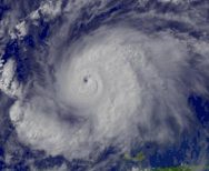 |
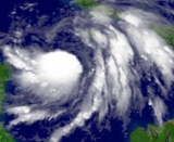
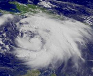
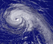
| Tropical Storm Wilma Hurricane Wilma Hurricane Wilma was the most intense tropical cyclone ever recorded in the Atlantic basin. Wilma was the twenty-second storm , thirteenth hurricane, sixth major hurricane, and fourth Category 5 hurricane of the record-breaking 2005 season... at T3.0 |
Tropical Storm Dennis Hurricane Dennis Hurricane Dennis was an early-forming major hurricane in the Caribbean and Gulf of Mexico during the very active 2005 Atlantic hurricane season. Dennis was the fourth named storm, second hurricane, and first major hurricane of the season... at T4.0 |
Hurricane Jeanne Hurricane Jeanne Hurricane Jeanne was the deadliest hurricane in the 2004 Atlantic hurricane season. It was the tenth named storm, the seventh hurricane, and the fifth major hurricane of the season, as well as the third hurricane and fourth named storm of the season to make landfall in Florida... at T5.0 |
Hurricane Emily Hurricane Emily (2005) Hurricane Emily was a powerful, early season tropical cyclone that caused significant damage across the Caribbean Sea to Mexico. A Cape Verde-type hurricane, the storm formed on July 10, 2005, in the central Atlantic Ocean before passing through the Windward Islands on July 14... at T6.0 |
See also
Other tools used to determine tropical cyclone intensity:- QuikscatQuikSCATThe QuikSCAT is an earth-observing satellite that provided estimates of wind speed and direction over the oceans to National Oceanic and Atmospheric Administration and others. This "quick recovery" mission intended to replace the NASA Scatterometer , which failed in June 1997...
- TRMMTropical Rainfall Measuring MissionThe Tropical Rainfall Measuring Mission is a joint space mission between NASA and the Japan Aerospace Exploration Agency designed to monitor and study tropical rainfall. The term refers to both the mission itself and the satellite that the mission uses to collect data...
Other methods used for determining intensity from satellite imagery:
- Extratropical transition techniqueExtratropical transition techniqueThe extratropical transition technique is a system used to subjectively estimate the intensity of tropical cyclones undergoing transition into extratropical cyclones based on visible and infrared satellite imagery...
- Hebert-Poteat technique
External links
Agencies issuing Dvorak intensity estimates- Joint Typhoon Warning Center
- UW–CIMSS (Advanced Dvorak Technique)
- NOAA/NESDIS Satellite Analysis Branch
- About the TAFB
Other
- Tropical Cyclone Intensity Analysis and Forecasting from Satellite Imagery Dvorak, 1974. (PDF, 1.3 MB)
- Dvorak Tropical Cyclone Wind Speed Biases Determined from Reconnaissance-based "Best Track" Data (1997-2003) Franklin and Brown
- The Dvorak Technique Through Time Dr. Jack Beven. (WRF File. Requires WebEx player)