
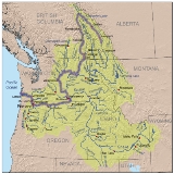
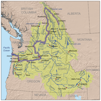
Tributaries of the Columbia River
Encyclopedia
Tributaries
and sub-tributaries are hierarchically listed in order from the mouth of the Columbia River
upstream. Major dams and reservoir lakes are also noted.
Tributary
A tributary or affluent is a stream or river that flows into a main stem river or a lake. A tributary does not flow directly into a sea or ocean...
and sub-tributaries are hierarchically listed in order from the mouth of the Columbia River
Columbia River
The Columbia River is the largest river in the Pacific Northwest region of North America. The river rises in the Rocky Mountains of British Columbia, Canada, flows northwest and then south into the U.S. state of Washington, then turns west to form most of the border between Washington and the state...
upstream. Major dams and reservoir lakes are also noted.
Minor tributaries
- Skipanon RiverSkipanon RiverThe Skipanon River is a tributary of the Columbia River, approximately long, on the Pacific coast of northwest Oregon in the United States. It is the last tributary of the Columbia on the Oregon side, draining an area of coastal bottom land bordered by sand dunes and entering the river from the...
(Oregon) - Lewis and Clark RiverLewis and Clark RiverThe Lewis and Clark River is a tributary of the Columbia River, approximately long, in northwest Oregon in the United States. It drains of the Northern Oregon Coast Range in the extreme northwest corner of the state, entering the Columbia near its mouth. Near the river's mouth is the site of...
(Oregon) - Youngs RiverYoungs RiverThe Youngs River is a tributary of the Columbia River, approximately long, in northwest Oregon in the United States. It drains part of the Northern Oregon Coast Range in the extreme northwest corner of state, entering the Columbia just upstream from its mouth.It rises in a remote section of the...
(Oregon)- Wallooskee RiverWallooskee RiverThe Wallooskee River is a tributary of the Youngs River, about long, in northwest Oregon in the United States. It drains a small area of the foothills of the Coast Range near the mouth of the Columbia River. The Youngs River is a tributary of the Columbia River.It rises southwest of Astoria in a...
(Oregon) - Klaskanine RiverKlaskanine RiverThe Klaskanine River is a tributary of the Youngs River, approximately long, in northwest Oregon in the United States. It drains a small section of the Coast Range in the extreme northwest corner of the state in the watershed of the nearby Columbia River....
(Oregon)
- Wallooskee River
- Elochoman RiverElochoman RiverThe Elochoman River is a tributary of the Columbia River, in the U.S. state of Washington. It is about long.The river's name comes from the name of a Cathlamet village.-Course:...
(Washington) - Clatskanie RiverClatskanie RiverThe Clatskanie River is a tributary of the Columbia River, approximately long, in northwestern Oregon in the United States. It drains a timber-producing area in the foothills of the Northern Oregon Coast Range north-northwest of Portland....
(Oregon) - Grays River (Washington)
- Cowlitz RiverCowlitz RiverThe Cowlitz River is a river in the state of Washington in the United States, a tributary of the Columbia River. Its tributaries drain a large region including the slopes of Mount Rainier, Mount Adams, and Mount St. Helens....
(Washington)- Coweeman RiverCoweeman RiverThe Coweeman River is a tributary of the Cowlitz River, in the U.S. state of Washington. Its name comes from the Cowlitz word ko-wee-na, meaning "short one", referring to a short Indian who once lived along the river.-Course:...
(Washington) - Toutle RiverToutle RiverThe Toutle River is a river in southwestern Washington State, in the Pacific Northwest region of the United States. It rises in two forks on the flanks of Mount St. Helens and joins the Cowlitz River near Castle Rock.-Eruption of Mount St. Helens:...
(Washington) - Mayfield DamLake MayfieldLake Mayfield is a reservoir located near Mossyrock, Washington, in Lewis County. It was created by Mayfield Dam on the Cowlitz River. The lake contains an island with a lighthouse....
and Lake MayfieldLake MayfieldLake Mayfield is a reservoir located near Mossyrock, Washington, in Lewis County. It was created by Mayfield Dam on the Cowlitz River. The lake contains an island with a lighthouse....
(Washington) - Tilton RiverTilton RiverThe Tilton River is a tributary of the Cowlitz River, in the U.S. state of Washington. Named for territorial surveyor James Tilton, its entire course is contained in Lewis County, Washington.-Course:...
(Washington) - Mossyrock DamMossyrock DamMossyrock Dam is a concrete arch-gravity dam on the Cowlitz River near Mossyrock in Lewis County, Washington. The reservoir created by the dam is called Riffe Lake and the primary purpose of the dam is hydroelectric production while flood control is secondary...
and Riffe LakeRiffe LakeRiffe Lake is a long reservoir on the Cowlitz River in the U.S. state of Washington. Originally named Davisson Lake, it was created in 1968 with the construction of Mossyrock Dam. The lake was renamed in 1976 after the community of Riffe, which was inundated by the lake....
(Washington) - Cowlitz Falls Dam and Lake Scanewa (Washington)
- Cispus RiverCispus RiverThe Cispus River is approximately 53 miles in length and flows into the Cowlitz River at Lake Scanewa in the Cascade Mountains of Washington. Its tributaries drain most of south-central and southeastern Lewis County, extreme northeast Skamania County, and some of western Yakima County.Its main...
(Washington) - Muddy Fork (Washington)
- Clear Fork (Washington)
- Ohanapecosh RiverOhanapecosh RiverThe Ohanapecosh River is a river in the U.S. state of Washington.It is the main headwater tributary of the Cowlitz River, which begins at the confluence of the Ohanapecosh River and the Clear Fork Cowlitz River. The Ohanapecosh originates near Ohanapecosh Glacier on the southeast side of Mount...
(Washington)
- Ohanapecosh River
- Coweeman River
- Kalama RiverKalama RiverThe Kalama River is a tributary of the Columbia River, in the U.S. state of Washington. Its entire course is contained in Cowlitz County, Washington. Calama River is an old variant name....
(Washington) - Lewis RiverLewis River (Washington)The Lewis River is a tributary of the Columbia River, about long, in southwestern Washington in the United States. It drains part of the Cascade Range north of the Columbia River. The drainage basin of the Lewis River covers about . The river's mean annual discharge is about . Unlike nearby Lewis...
(Washington)- Merwin DamMerwin DamMerwin Dam is a concrete arch gravity-type hydroelectric dam on the Lewis River, in the U.S. state of Washington. It is located on the border between Cowlitz County and Clark County. Its reservoir is called Lake Merwin....
and Lake MerwinLake MerwinLake Merwin is a reservoir on the Lewis River in the U.S. state of Washington. It lies on the border between Clark County and Cowlitz County. It was created in 1931 with the construction of Merwin Dam....
(Washington) - Yale DamYale DamYale Dam is a 323-foot high earth-type hydroelectric dam on the Lewis River, in the U.S. state of Washington, owned by PacifiCorp. It is located on the border between Cowlitz County and Clark County. Its reservoir is called Yale Lake. The dam's power plant generates 134 megawatts.-References:...
and Yale LakeYale LakeYale Lake is a 3,780 acre reservoir on the Lewis River in the U.S. state of Washington. It lies on the border between Clark County and Cowlitz County. It was created in 1953 with the construction of Yale Dam....
(Washington) - Swift DamSwift DamSwift Dam or Swift No. 1 is an earth-type hydroelectric dam on the Lewis River, in the U.S. state of Washington. It is located in Skamania County. Its reservoir is called Swift Reservoir.-References:...
and Swift ReservoirSwift ReservoirSwift Reservoir is a reservoir on the Lewis River in the U.S. state of Washington. It is located in Skamania County. It was created in 1958 with the construction of Swift Dam....
(Washington)
- Merwin Dam
- Lake RiverLake River (Washington)Lake River is an approximately 10-mile long, typically slow-moving waterway that runs parallel to the Columbia River. From Vancouver Lake it flows north to the northern tip of Bachelor Island....
(Washington)
- Willamette RiverWillamette RiverThe Willamette River is a major tributary of the Columbia River, accounting for 12 to 15 percent of the Columbia's flow. The Willamette's main stem is long, lying entirely in northwestern Oregon in the United States...
(Oregon; see below for sub-tributaries)
- Washougal RiverWashougal RiverThe Washougal River is a shallow tributary of the Columbia River. Its mouth is located near the towns of Washougal and Camas, Washington. The Washougal river is a popular site for fishing, swimming, and tubing....
(Washington) - Sandy RiverSandy River (Oregon)The Sandy River is a tributary of the Columbia River in northwestern Oregon in the United States. Measured by a United States Geological Survey gauge downstream of the Sandy's confluence with the Bull Run River, from the mouth, the river's average discharge is . The maximum daily recorded flow...
(Oregon)- Salmon RiverSalmon River (Clackamas County, Oregon)The Salmon River is a 33.9 mile river in Oregon's Cascade Range and drains a portion of southwestern Mount Hood.The entire length of the river is protected National Wild and Scenic River, the only such river in the contiguous 48 states....
(Oregon) - Zigzag RiverZigzag RiverThe Zigzag River is a tributary, about long, of the Sandy River in the U.S. state of Oregon. The Zigzag and one of its major tributaries, the Little Zigzag River, drain the Zigzag Glacier on Mount Hood, a high volcanic peak in the Cascade Range. Their waters flow westward to meet the Sandy River...
(Oregon)
- Salmon River
- Bonneville DamBonneville DamBonneville Lock and Dam consists of several run-of-the-river dam structures that together complete a span of the Columbia River between the U.S. states of Oregon and Washington at River Mile 146.1. The dam is located east of Portland, Oregon, in the Columbia River Gorge. The primary functions of...
and Lake BonnevilleLake Bonneville (Oregon)Lake Bonneville is a reservoir on the Columbia River in the U.S. states of Oregon and Washington. It was created in 1937 with the construction of Bonneville Dam. The reservoir stretches between it and The Dalles Dam, upstream. It lies in parts of three counties in Oregon and two in Washington ....
(Washington, Oregon) - Wind RiverWind River (Washington)The Wind River is a tributary of the Columbia River, in the U.S. state of Washington. Its entire course is contained in Skamania County, Washington. Crusattes River is an old variant name.-Course:...
(Washington) - White Salmon RiverWhite Salmon RiverThe White Salmon River is a river flowing into the Columbia River Gorge, originating on the slopes of Mount Adams. The lower portion of the river is in the Columbia River Gorge National Scenic Area and some of the upper sections are part of the National Wild and Scenic Rivers system...
(Washington) - Hood River (Oregon)
- Klickitat RiverKlickitat RiverThe Klickitat River is a tributary of the Columbia River, approximately long, in south-central Washington in the United States. It drains a rugged plateau area on the eastern side of the Cascade Range northeast of Portland, Oregon...
(Washington) - The Dalles Dam and Lake CeliloLake CeliloLake Celilo is a long reservoir on the Columbia River in the United States, between the U.S. states of Washington and Oregon. It was created in 1957 with the construction of The Dalles Dam near The Dalles, Oregon, and stretches upstream to the John Day Dam. Its filling drowned the former site of...
(Washington, Oregon) - Deschutes River (Oregon)
- Warm Springs RiverWarm Springs RiverThe Warm Springs River is a river in northern Central Oregon, United States, which drains the east side of the Cascade Range and is a tributary to the Deschutes River. The watershed is approximately between Mount Jefferson and Timothy Lake and appears the northwestern and southwestern boundaries...
(Oregon) - Round Butte DamRound Butte DamRound Butte Dam is a rockfill-type hydroelectric dam on the Deschutes River, in the U.S. state of Oregon. It is located in Jefferson County. Its reservoir is called Lake Billy Chinook.-References:...
and Lake Billy Chinook (Oregon) - Crooked RiverCrooked River (Oregon)The Crooked River is a tributary, long, of the Deschutes River in the U.S. state of Oregon. The river begins at the confluence of South Fork Crooked River and Beaver Creek. Of the two tributaries, the South Fork Crooked River is the larger and is sometimes considered part of the Crooked River proper...
(Oregon)- Arthur R. Bowman DamArthur R. Bowman DamArthur R. Bowman Dam is an earth-type irrigation dam on the Crooked River in the U.S. state of Oregon. It is located in Crook County. Its reservoir is called Prineville Reservoir.-References:...
and Prineville ReservoirPrineville ReservoirThe Prineville Reservoir is located in the high desert hills of Central Oregon, Oregon, United States. The reservoir is on the Crooked River located southeast of Prineville, OR, and east of Bend, Oregon . This reservoir is a popular retreat for most of Central Oregon...
(Oregon)
- Arthur R. Bowman Dam
- Metolius RiverMetolius RiverThe Metolius River is a tributary of the Deschutes River in Central Oregon, United States, near the city of Sisters. The river flows north from springs near Black Butte, then turns sharply east, descending through a series of gorges before ending in the western end of the lake...
(Oregon) - White RiverWhite River (Oregon)The White River is a tributary of the Deschutes River, approximately 50 mi long, in north central Oregon in the United States. It drains a scenic mountainous area of the Columbia Plateau on the east side of the Cascade Range southeast of Mount Hood. In the 1840s, a section of the Oregon...
(Oregon) - Little Deschutes RiverLittle Deschutes RiverThe Little Deschutes River is a tributary of the Deschutes River in the central part of the U.S. state of Oregon. It is about long, with a drainage basin of...
(Oregon)
- Warm Springs River
- John Day DamJohn Day DamThe John Day Dam is a concrete gravity run-of-the-river dam spanning the Columbia River in the northwestern United States. The dam features a navigation lock plus fish ladders on both sides. The John Day Lock has the highest lift of any U.S. lock...
and Lake UmatillaLake UmatillaLake Umatilla is a long reservoir on the Columbia River in the United States, between the U.S. states of Washington and Oregon. It was created in 1971 with the construction of John Day Dam, and stretches upstream to the McNary Dam. It lies in parts of Sherman, Gilliam, Morrow, and Umatilla...
(Washington, Oregon) - John Day RiverJohn Day RiverThe John Day River is a tributary of the Columbia River, approximately long, in northeastern Oregon in the United States. Undammed along its entire length, the river is the third longest free-flowing river in the conterminous United States. There is extensive use of its waters for irrigation. Its...
(Oregon) - Umatilla RiverUmatilla RiverThe Umatilla River is an tributary of the Columbia River in the U.S. state of Oregon. Draining a basin of , it enters the Columbia near the city of Umatilla in the northeastern part of the state...
(Oregon) - McNary DamMcNary DamMcNary Dam is a 1.4-mile long concrete gravity run-of-the-river dam which spans the Columbia River. It joins Umatilla County, Oregon with Benton County, Washington, 292 miles upriver from the mouth of the Columbia at Astoria, Oregon. It is operated by the U.S. Army Corps of Engineers' McNary...
and Lake WallulaLake WallulaLake Wallula is a reservoir on the Columbia River in the United States, between the U.S. states of Washington and Oregon. It was created in 1954 with the construction of McNary Dam. It reaches from McNary Dam near the city of Umatilla, Oregon, to the Tri-Cities of Washington.-See also:* Wallula...
(Washington, Oregon) - Walla Walla RiverWalla Walla RiverThe Walla Walla River is a tributary of the Columbia River, joining the Columbia just above Wallula Gap in southeastern Washington in the United States. The river flows through Umatilla County, Oregon and Walla Walla County, Washington. Its drainage basin is in area.-Course:The headwaters of the...
(Washington, Oregon)- Touchet RiverTouchet RiverThe Touchet River is the largest tributary of the Walla Walla River in southeastern Washington in the United States.The upper Touchet was a traditional summer meeting place for trade and games for the Palus, Nez Perce and Walla Walla tribes. The name Touchet derives from the similarly pronounced...
(Washington)
- Touchet River
- Snake RiverSnake RiverThe Snake is a major river of the greater Pacific Northwest in the United States. At long, it is the largest tributary of the Columbia River, the largest North American river that empties into the Pacific Ocean...
(Washington, Oregon, Idaho, Wyoming; see below for sub-tributaries)
- Yakima RiverYakima RiverThe Yakima River is a tributary of the Columbia River in south central and eastern Washington State, named for the indigenous Yakama people. The length of the river from headwaters to mouth is , with an average drop of .-Course:...
(Washington; see below for sub-tributaries)
- Priest Rapids DamPriest Rapids DamPriest Rapids Dam is a hydroelectric, concrete gravity dam; located on the Columbia River, between the Yakima Firing Range and the Hanford Nuclear Reservation, and bridges Yakima County and Grant County, in the U.S. state of Washington. The dam is 24 miles south of the town of Vantage, and 47 miles...
(Washington) and Priest Rapids LakePriest Rapids LakePriest Rapids Lake is a reservoir on the Columbia River in the U.S. state of Washington. It was created in 1959 with the construction of Priest Rapids Dam. The reservoir stretches from there upstream to the Wanapum Dam....
(Washington) - Crab CreekCrab CreekCrab Creek is a stream in the U.S. state of Washington. Named for the presence of crayfish, it is one of the few perennial streams in the Columbia Basin of central Washington, flowing from the northeastern Columbia River Plateau, roughly east of Reardan, west-southwest to empty into the Columbia...
(Washington) - Wanapum DamWanapum DamWanapum Dam is a hydroelectric project located on the Columbia River downstream from Vantage, Washington where Interstate 90 crosses the Columbia from Grant County into Kittitas County. It is owned by the Grant County Public Utility District. Its reservoir is named Lake Wanapum.The dam, and its...
(Washington) and Lake WanapumLake WanapumWanapum Lake is a reservoir on the Columbia River in the U.S. state of Washington. It was created in 1963 with the construction of Wanapum Dam. It stretches from there upstream to the Rock Island Dam. The lake is named for the Wanapum people....
(Washington) - Rock Island DamRock Island DamRock Island Dam is a hydroelectric dam on the Columbia River in the U.S. state of Washington. Chelan County Public Utility District's Rock Island Dam and Hydro Project was the first dam to span the Columbia, having been built from 1929 to 1933. It is located near the geographical center of...
(Washington) and Rock Island PoolRock Island PoolRock Island Pool is a reservoir on the Columbia River in the U.S. state of Washington. It was created in 1933 with the construction of Rock Island Dam. The reservoir stretches from there upstream to the Rocky Reach Dam....
(Washington) - Wenatchee RiverWenatchee RiverThe Wenatchee River is a river in the U.S. state of Washington, originating at Lake Wenatchee and flowing southeast for , emptying into the Columbia River immediately north of Wenatchee, Washington...
(Washington)- Chiwawa RiverChiwawa RiverThe Chiwawa River is a tributary of the Wenatchee River, in the U.S. state of Washington. It is completely contained within Chelan County.Much of the Chiwawa River's drainage basin is designated national forest and wilderness...
(Washington) - Lake Wenatchee
- Little Wenatchee RiverLittle Wenatchee RiverThe Little Wenatchee River is the southern and smaller of the two rivers that flow into the west end of Lake Wenatchee. The northern and larger one is the White River. A large number of place names in the Little Wenatchee River basin, including the river's name itself, were given by Albert H...
- White River
- Napeequa RiverNapeequa RiverThe Napeequa River is a long river in the U.S. state of Washington on the east side of the Cascade Range. It rises in northwest Chelan County and flows southwest into the White River near Twin Lakes. The White River flows into Lake Wenatchee. The Napeequa River and its valley are notable for their...
- Napeequa River
- Little Wenatchee River
- Chiwawa River
- Rocky Reach DamRocky Reach DamRocky Reach Dam is a hydroelectric dam in the U.S. state of Washington. Chelan County Public Utility District's Rocky Reach Dam and Hydro Project is located in north central Washington state, USA on the Columbia River, about seven miles upstream from the city of Wenatchee...
and Lake EntiatLake EntiatLake Entiat is a reservoir between Chelan County and Douglas County in North Central Washington that is formed above Rocky Reach Dam , a hydroelectric dam on the Columbia River. The reservoir is north of Wenatchee and stretches upstream to the Wells Dam. Lincoln Rock State Park is on its east...
(Washington) - Entiat RiverEntiat RiverThe Entiat River is a tributary of the Columbia River, joining the Columbia near Entiat. The USGS lists two variant names for the Entiat River: En-ti-at-kwa River and Entiatqua River. En-ti-at-kwa is noted as being the original "Indian name", meaning "rapid water"...
(Washington)- Mad RiverMad River (Washington)The Mad River is a river in the U.S. state of Washington. It rises in the Cascade Mountains and flows southeast to join the Entiat River. It is part of the Columbia River basin, being a tributary of the Entiat River, which empties into the Columbia River....
(Washington)
- Mad River
- Chelan RiverChelan RiverThe Chelan River is a tributary of the Columbia River, in the U.S. state of Washington. Just long, it is the shortest river in Washington. Lake Chelan Dam is located at the river's source: the outlet of Lake Chelan. Nearly the entire river's flow is diverted to the Lake Chelan Powerhouse, ...
(and Lake ChelanLake ChelanLake Chelan is a narrow, 55-mile-long lake in Chelan County, northern Washington state, U.S. It is the largest natural lake in Washington state...
) (Washington)- Stehekin RiverStehekin RiverThe Stehekin River is a river located in Washington state in the Pacific Northwest of the United States. It is the main river flowing into Lake Chelan. Miners arrived in Stehekin River Valley in the late 19th century. They were followed by homesteaders in the early 20th century...
(Washington)
- Stehekin River
- Wells DamWells DamWells Dam is a hydroelectric dam located on the Columbia River, downstream from the confluence of the Okanogan River, Methow River, and the Columbia River in Washington State. The dam, associated structures, and machinery make up the Wells Hydroelectric Project. It is owned and operated by...
and Lake PaterosLake PaterosLake Pateros is a reservoir on the Columbia River in the U.S. state of Washington. It was created in 1967 with the construction of Wells Dam. The reservoir lies almost entirely in Douglas and Okanogan counties, although the dam itself lies partially in the easternmost portion of Chelan County. The...
(Washington) - Methow RiverMethow RiverThe Methow River is a tributary of the Columbia River in northern Washington in the United States. The river's watershed is , with a population of about 5,000 people. The Methow's watershed is characterized by relatively pristine habitats, with much of the river basin is located in national forests...
(Washington)- Twisp RiverTwisp RiverThe Twisp River is a tributary of the Methow River, in the U.S. state of Washington. It is about 26 miles long.The name of the river is derived from a local Indian word meaning "wasp" or "yellowjacket".-Course:...
(Washington)
- Twisp River
- Okanogan RiverOkanogan RiverThe Okanogan River is a tributary of the Columbia River, approximately 115 mi long, in southern British Columbia and north central Washington...
(Washington, British Columbia)- Similkameen RiverSimilkameen RiverThe Similkameen River runs through southern British Columbia, eventually discharging into the Okanogan River near Oroville, Washington in the United States. The river is approximately long, and its drainage basin is in area...
(British Columbia, Washington)- Tulameen RiverTulameen RiverThe Tulameen River is a tributary of the Similkameen River in the Canadian province of British Columbia. The Tulameen River is part of the Columbia River drainage basin, being a tributary of the Similkameen River, which flows into the Okanagan River, which flows into the Columbia River.-Course:The...
(British Columbia) - Pasayten RiverPasayten RiverThe Pasayten River is a tributary of the Similkameen River, in the Canadian province of British Columbia and the U.S. state of Washington.The Pasayten River is part of the Columbia River drainage basin, being a tributary of the Similkameen River, which flows into the Okanagan River, which flows...
(British Columbia, Washington)
- Tulameen River
- Okanagan LakeOkanagan LakeOkanagan Lake is a large, deep lake in the Okanagan Valley of British Columbia. The lake is 135 km long, between 4 and 5 km wide, and has a surface area of 351 km². The lake's maximum depth is 232 meters near Grant Island...
(British Columbia)
- Similkameen River
- Chief Joseph DamChief Joseph DamThe Chief Joseph Dam is a concrete gravity dam on the Columbia River, upriver from Bridgeport, Washington, USA. The dam was authorized as Foster Creek Dam and Powerhouse for power generation and irrigation by the River and Harbor Act of 1946...
and Rufus Woods Lake (Washington) - Nespelem RiverNespelem RiverThe Nespelem River is a northern tributary of the Columbia River, in the U.S. state of Washington. It is completely contained within Okanogan County and the Colville Indian Reservation....
(Washington) - Grand Coulee DamGrand Coulee DamGrand Coulee Dam is a gravity dam on the Columbia River in the U.S. state of Washington built to produce hydroelectric power and provide irrigation. It was constructed between 1933 and 1942, originally with two power plants. A third power station was completed in 1974 to increase its energy...
and Franklin D. Roosevelt LakeFranklin D. Roosevelt LakeFranklin D. Roosevelt Lake is the reservoir created in 1941 by the impoundment of the Columbia River by the Grand Coulee Dam in Washington state. It is named for Franklin D. Roosevelt, who was President during the construction of the dam...
(Washington) - Sanpoil RiverSanpoil RiverThe Sanpoil River is a tributary of the Columbia River, in the U.S. state of Washington. The term Sanpoil is from the Okanagan term [snpʕʷílx], meaning "people of the gray country", or "gray as far as one can see".-Course:...
(Washington) - Spokane RiverSpokane RiverThe Spokane River is a tributary of the Columbia River, approximately long, in northern Idaho and eastern Washington in the United States. It drains a low mountainous area east of the Columbia, passing through the city of Spokane, Washington.-Description:...
(Washington, Idaho)- Spokane FallsSpokane FallsSpokane Falls is the name of the series of waterfalls and dams on the Spokane River in downtown Spokane, Washington.The Indian name for the Spokane Falls was "Stluputqu", meaning "swift water". The falls was once the site of a large Spokane people village....
(Washington) - Little Spokane RiverLittle Spokane RiverThe Little Spokane River is a major tributary of the Spokane River, approximately 35 mi long, in eastern Washington in the United States. It drains a rural area of forested foothills and a farming valley north of the city of Spokane along the Idaho-Washington border.It rises in southern Pend...
(Washington) - Latah CreekLatah CreekLatah Creek, also known as Hangman Creek, is a large stream in eastern Washington and north central Idaho in the United States. The creek flows northwest from the Rocky Mountains to Spokane, where it empties into the Spokane River...
(Washington and Idaho) - Lake Coeur d'AleneLake Coeur d'AleneLake Coeur d'Alene is a natural lake in the Idaho Panhandle, located in the vicinity of the city of the same name. It spans long, ranges from 1 to wide and has over of shoreline for boaters and vacationers to explore and enjoy.-Geology and geography:...
(Idaho)- Coeur d'Alene RiverCoeur d'Alene RiverThe Coeur d'Alene River flows from the Silver Valley into Lake Coeur d'Alene in the U.S. state of Idaho. The stream continues out of Lake Coeur d'Alene as the Spokane River...
(Idaho) - Saint Joe RiverSaint Joe RiverThe Saint Joe River is a river in northern Idaho that winds through the Saint Joe River Valley, through Avery, Calder, and St. Maries. Eventually the river dumps into Coeur d'Alene Lake...
(Idaho) - Saint Maries RiverSaint Maries RiverSaint Maries River is a river located in the U.S. state of Idaho. It is a tributary of Coeur d'Alene Lake and thus part of the Spokane River drainage basin and the Columbia River Basin. The West and Middle Forks of the river join near Clarkia, Idaho and run parallel to State Highway 3 in a...
(Idaho)
- Coeur d'Alene River
- Spokane Falls
- Colville RiverColville River (Washington)The Colville River is a 60 mile long tributary of the Columbia River in northeastern Washington in the United States.-Course:The Colville River begins in southern Stevens County, Washington at the confluence of Sheep Creek and Deer Creek. It flows northwest past Colville and into the Columbia...
(Washington) - Kettle RiverKettle River (Columbia River)The Kettle River is a tributary of the Columbia River in northeastern Washington in the United States and southeastern British Columbia in Canada. Its drainage basin is large, of which are in Canada and in the United States.-Course:...
(Washington, British Columbia)- Granby RiverGranby RiverThe Granby River is a tributary of the Kettle River in British Columbia, Canada, joining the Kettle just north of the US-Canada border at the town of Grand Forks...
(British Columbia) - West Kettle RiverWest Kettle RiverThe West Kettle River is a tributary of the Kettle River in the Canadian province of British Columbia. It is part of the Columbia River basin, as the Kettle River is a tributary of the Columbia River.-Course:...
(British Columbia)
- Granby River
- Pend Oreille RiverPend Oreille RiverThe Pend Oreille River is a tributary of the Columbia River, approximately long, in northern Idaho and northeastern Washington in the United States, as well as southeastern British Columbia in Canada. In its passage through British Columbia its name is spelled Pend-d'Oreille River...
(British Columbia, Washington, Idaho; see below for sub-tributaries)
- Kootenay RiverKootenay RiverThe Kootenay is a major river in southeastern British Columbia, Canada and the northern part of the U.S. states of Montana and Idaho. It is one of the uppermost major tributaries of the Columbia River, which is the largest North American river that empties into the Pacific Ocean...
(British Columbia, Idaho, Montana; see below for sub-tributaries)
- Hugh Keenleyside DamKeenleyside DamHugh Keenleyside Dam is a hydroelectric dam spanning the Columbia River, 12 km upstream of the city of Castlegar, British Columbia, Canada....
and Arrow LakesArrow LakesThe Arrow Lakes in British Columbia, Canada, divided into Upper Arrow Lake and Lower Arrow Lake, are widenings of the Columbia River. The lakes are situated between the Selkirk Mountains to the east and the Monashee Mountains to the west. Beachland is fairly rare, and is interspersed with rocky...
(British Columbia) - Whatshan RiverWhatshan RiverThe Whatshan River is a tributary of the Columbia River in the Canadian province of British Columbia. The river's drainage basin is approximately in area.-Course:...
(British Columbia)- Whatshan DamWhatshan DamWhatshan Dam is a concrete hydroelectric dam on the Whatshan Riverin the Canadian province of British Columbia. It is located on the western side of Lower Arrow Lake in the Monashee Mountains.- References :...
(British Columbia)
- Whatshan Dam
- Beaton CreekBeaton CreekBeaton Creek is a tributary of the Columbia River in the Canadian province of British Columbia.-Course:Beaton Creek flows generally northwest into Beaton Arm and Upper Arrow Lake, part of the Columbia River....
(British Columbia) - Incomappleux RiverIncomappleux RiverThe Incomappleux River is a major tributary of the Columbia River in British Columbia, Canada, entering that river via the Beaton Arm of Upper Arrow Lake.The area is the upper end of the Lardeau district...
(British Columbia) - Illecillewaet RiverIllecillewaet RiverThe Illecillewaet River is a tributary of the Columbia River located in British Columbia, Canada. Fed by the Illecillewaet Glacier in Glacier National Park, the river flows approximately to the southwest, where it flows into the north end of Upper Arrow Lake at Revelstoke...
(British Columbia) - Revelstoke DamRevelstoke DamThe Revelstoke Dam, also known as Revelstoke Canyon Dam, is a hydroelectric dam spanning the Columbia River, 5 km north of Revelstoke, British Columbia, Canada. The powerhouse was completed in 1984 and has a generating capacity of 2480 MW. Four generating units were installed initially, with one...
and Revelstoke LakeRevelstoke LakeLake Revelstoke or Revelstoke Lake or Revelstoke Lake Reservoir is an artificial lake on the Columbia River, north of the town of Revelstoke, British Columbia and south of Mica Creek...
(British Columbia) - Goldstream RiverGoldstream RiverThe Goldstream River is a tributary of the Columbia River, joining that stream via the Lake Revelstoke reservoir after running largely west from the heart of the northern Selkirk Mountains. The river's name derives from the Big Bend Gold Rush of 1865, during which it was the scene of busy...
(British Columbia) - Mica DamMica DamThe Mica Dam is a hydroelectric dam spanning the Columbia River 135 kilometres north of Revelstoke, British Columbia, Canada. Completed in 1973 under the terms of the 1964 Columbia River Treaty, the Mica powerhouse has a generating capacity of . The dam is operated by BC Hydro...
and Kinbasket LakeKinbasket LakeKinbasket Lake is a reservoir on the Columbia River in southeast British Columbia, north of the city of Revelstoke and the town of Golden. The reservoir was created by the construction of the Mica Dam. The lake includes two reaches, Columbia Reach and Canoe Reach , referring to the river valleys...
(British Columbia) - Canoe RiverCanoe River (British Columbia)Canoe River is a tributary of the Columbia River in British Columbia, Canada. Its lower reach is flooded by Mica Dam. The lower Canoe River is called Canoe Reach, part of the Mica Dam's reservoir, Kinbasket Lake.-Course:...
(British Columbia) - Wood RiverWood River (British Columbia)The Wood River is a tributary of the Columbia River in the Canadian province of British Columbia. The river's lower reach is flooded by Mica Dam on the Columbia River, until its inundation the river was formerly a tributary of the Canoe River. The lower Wood River is called Wood Reach, which is...
(British Columbia) - Bush RiverBush River (British Columbia)The Bush River is a tributary of the Columbia River in the Columbia Country of southeastern British Columbia, Canada, entering that river via the Bush Arm of Kinbasket Lake. Named for the dense vegetation lining its banks, its headwaters are at , in the Rocky Mountains...
(British Columbia]]- Valenciennes RiverValenciennes RiverThe Valenciennes River is a tributary of the Bush River, entering that river just above its mouth into Kinbasket Lake, the reservoir on the Columbia River created by the Mica Dam in southeastern British Columbia, Canada. The Valenciennes was originally known as the South Fork Bush River....
(British Columbia)
- Valenciennes River
- Blaeberry RiverBlaeberry RiverThe Blaeberry River is a tributary of the Columbia River in the Columbia Country of British Columbia, Canada, rising in the Canadian Rockies on the south side of Howse Pass and joining the Columbia midway between the town of Golden, at the confluence of the Kicking Horse River, and the east foot of...
(British Columbia) - Beaver River (British Columbia)
- Kicking Horse RiverKicking Horse RiverThe Kicking Horse River is a river located in the Canadian Rockies of southeastern British Columbia, Canada.The river was named in 1858, when James Hector, a member of the Palliser Expedition, was kicked by his packhorse while exploring the river. Hector survived and named the river and the...
(British Columbia)- Yoho RiverYoho RiverThe Yoho River is a silty, swift tributary of the Kicking Horse River in the Canadian province of British Columbia. The river is located entirely within Yoho National Park.-Course:...
(British Columbia)
- Yoho River
- Spillimacheen RiverSpillimacheen RiverThe Spillimacheen River is a tributary of the Columbia River in the Canadian province of British Columbia.-Course:The Spillimacheen River originates just east of Glacier National Park...
(British Columbia) - Templeton RiverTempleton RiverThe Templeton River is a short, river in British Columbia. It is a tributary of the Columbia River, entering the Columbia via the Columbia Wetlands, upstream from the mouth of the Spillimacheen River.- Course :...
- Columbia LakeColumbia LakeColumbia Lake is the primary lake at the headwaters of the Columbia River, in British Columbia, Canada. It is fed by several small tributaries. The village of Canal Flats is located at the south end of the lake....
(British Columbia)
Willamette River system
- Multnomah ChannelMultnomah ChannelMultnomah Channel is a distributary of the Willamette River that splits from the main stem a few miles upstream of the Willamette's convergence with the Columbia River in Multnomah County in the U.S. state of Oregon. The channel flows northwest then north around Sauvie Island for about to meet the...
(Oregon) - Johnson Creek (Oregon)
- Clackamas RiverClackamas RiverThe Clackamas River is an approximately tributary of the Willamette River in northwestern Oregon, in the United States. As it drains an area of about , the Clackamas passes through mostly forested and rugged mountainous terrain in its upper reaches, and passes through agricultural and urban areas...
(Oregon)- Collawash RiverCollawash RiverThe Collawash River is a tributary of the Clackamas River in the U.S. state of Oregon. Formed by the confluence of Elk Lake Creek and the East Fork Collawash River in the Cascade Range, it flows generally north-northwest from source to mouth through the Mount Hood National Forest. The largest...
(Oregon)
- Collawash River
- Tualatin RiverTualatin RiverThe Tualatin River is a tributary of the Willamette River located in Oregon in the United States. The river is approximately long, and it drains a fertile farming region called the Tualatin Valley southwest and west of Portland at the northwest corner of the Willamette Valley...
(Oregon) - Molalla RiverMolalla RiverThe Molalla River is a tributary of the Willamette River in the U.S. state of Oregon.-Geography:Its headwaters are in Clackamas County, in the Table Rock Wilderness, near Table Rock, in the Cascade Range...
(Oregon)- Pudding RiverPudding RiverThe Pudding River is a tributary of the Molalla River in the U.S. state of Oregon. Its drainage basin covers . Among its tributaries is the Little Pudding River...
(Oregon)
- Pudding River
- Yamhill RiverYamhill RiverThe Yamhill River is an tributary of the Willamette River, in the U.S. state of Oregon. Formed by the confluence of the South Yamhill River and the North Yamhill River about east of McMinnville, it drains part of the Northern Oregon Coast Range...
(Oregon)- North Yamhill RiverNorth Yamhill RiverThe North Yamhill River is a tributary of the Yamhill River in the U.S. state of Oregon. It drains an area of the Northern Oregon Coast Range, as well as part of the Willamette Valley west of the Willamette River....
(Oregon) - South Yamhill RiverSouth Yamhill RiverThe South Yamhill River is a tributary of the Yamhill River, approximately long, in northwest Oregon in the United States. It drains an area of the Northern Oregon Coast Range, as well as part of the Willamette Valley west of the Willamette River.-Course:...
(Oregon)
- North Yamhill River
- Luckiamute RiverLuckiamute RiverThe Luckiamute River is a tributary of the Willamette River, about long, in western Oregon in the United States. It drains an area of Central Oregon Coast Range and the western Willamette Valley northwest of Corvallis....
(Oregon) - Santiam RiverSantiam RiverThe Santiam River is a tributary of the Willamette River, about long, in western Oregon in the United States. Through its two principal tributaries, the North Santiam and the South Santiam rivers, it drains a large area of the Cascade Range at the eastern side of the Willamette Valley east of...
(Oregon)- North Santiam RiverNorth Santiam RiverThe North Santiam River is a tributary of the Santiam River in western Oregon in the United States. It drains of the Cascade Range on the eastern side of the Willamette Valley east of Salem....
(Oregon) - Detroit DamDetroit DamDetroit Dam was completed in 1953 by the U.S. Army Corp of Engineers on the North Santiam River between Linn County and Marion County, Oregon, in the Cascades...
and Detroit LakeDetroit LakeDetroit Lake is a reservoir impounded by the Detroit Dam on the North Santiam River southeast of Salem, Oregon, United States.The lake is adjacent to Oregon Route 22 near the city of Detroit....
(Oregon)- Breitenbush RiverBreitenbush RiverThe Breitenbush River is a tributary of the North Santiam River in western Oregon in the United States. It drains a rugged, forested area of the Cascade Range east of Salem....
(Oregon)
- Breitenbush River
- South Santiam RiverSouth Santiam RiverThe South Santiam River is a tributary of the Santiam River, about long, in western Oregon in the United States. It drains an area of the Cascade Range into the Willamette Valley east of Corvallis....
(Oregon)- Middle Santiam RiverMiddle Santiam RiverThe Middle Santiam River is a tributary of the South Santiam River, long, in western Oregon in the United States. It drains a remote area of the Cascade Range east of Corvallis in the watershed of the Willamette River....
(Oregon)
- Middle Santiam River
- North Santiam River
- Calapooia RiverCalapooia RiverThe Calapooia River is a tributary of the Willamette River in the U.S. state of Oregon.The Calapooia runs through Crawfordsville and Brownsville in the Willamette Valley. The river converges with the Willamette near Albany. It was named for the Kalapuya , a tribe of Native Americans.-References:...
(Oregon) - Marys RiverMarys RiverMarys River is a tributary of the Willamette River in the U.S. state of Oregon. From its source at the confluence of its east and west forks near Summit, it flows generally southeast from the Central Oregon Coast Range to Corvallis.-Name:...
(Oregon) - Long Tom RiverLong Tom RiverThe Long Tom River is a tributary of the Willamette River in western Oregon in the United States. It drains an area at the south end of the Willamette Valley between Eugene and Corvallis....
(Oregon) - McKenzie RiverMcKenzie RiverThe McKenzie River is a tributary of the Willamette River in western Oregon in the United States. It drains part of the Cascade Range east of Eugene and flows into the southernmost end of the Willamette Valley. It is named for Donald MacKenzie, a Scottish Canadian fur trader...
(Oregon)- Mohawk RiverMohawk River (Oregon)The Mohawk River is the largest tributary of the McKenzie River, approximately long, in west central Oregon in the United States. It drains part of the foothills of the Cascade Range on the southeast end of the Willamette Valley northeast of Springfield....
(Oregon) - Cougar DamCougar DamCougar Dam is a tall rockfill hydroelectric dam in the U.S. state of Oregon. It has a gated concrete spillway and a powerhouse with two turbines totaling 25 megawatts of electric power....
and Cougar ReservoirCougar ReservoirCougar Reservoir is a reservoir on the South Fork McKenzie River in the U.S. state of Oregon. It is located in Lane County. It was created in 1964 with the construction of the hydroelectric Cougar Dam....
(Oregon)
- Mohawk River
- Coast Fork Willamette RiverCoast Fork Willamette RiverThe Coast Fork Willamette River is one of several forks that unite to form the Willamette River in western Oregon in the United States. It is about long, draining an area of the mountains at the south end of the Willamette Valley south of Eugene.-Course:...
(Oregon)- Big RiverBig River (Oregon)The Big River is a tributary of the Coast Fork Willamette River, approximately 12 mi long, in western Oregon in the United States. It drains an area of the Calapooya Mountains south of Eugene....
(Oregon)
- Big River
- Middle Fork Willamette RiverMiddle Fork Willamette RiverThe Middle Fork Willamette River is one of several forks that unite to form the Willamette River in the western part of the U.S. state of Oregon...
(Oregon)- Lookout Point DamLookout Point DamLookout Point Dam is an earth-type dam on the Middle Fork Willamette River in the U.S. state of Oregon. It is located in Lane County. Its reservoir is called Lookout Point Lake. The dam's primary purpose is flood control, and secondarily irrigation....
and Lookout Point LakeLookout Point LakeLookout Point Lake is a reservoir on the Middle Fork Willamette River in Lane County, Oregon, United States. It was created in 1953 with the construction of Lookout Point Dam....
(Oregon) - North Fork Middle Fork Willamette RiverNorth Fork Willamette RiverThe North Fork Middle Fork Willamette River as it is officially named but frequently called North Fork of the Willamette River or North Fork of the Middle Fork of the Willamette River has its headwaters at Waldo Lake and flows into the Middle Fork Willamette River northwest of Oakridge...
(Oregon)
- Lookout Point Dam
Snake River system
- Ice Harbor DamIce Harbor Lock and DamIce Harbor Lock and Dam is a hydroelectric, concrete gravity run-of-the-river dam on the Snake River in Walla Walla and Franklin counties in the U.S. state of Washington. The dam is located 8 miles northeast of the town of Burbank and 12 miles east of Pasco, river mile 9.2...
and Lake SacajaweaLake Sacajawea (Washington)Lake Sacajawea is formed by the Ice Harbor Dam on the Snake River. It stretches from there upstream to the Lower Monumental Dam. It is named for Sacajawea, a Shoshone woman who accompanied Meriwether Lewis and William Clark during their exploration of the American West....
(Washington) - Lower Monumental DamLower Monumental Lock and DamLower Monumental Lock and Dam is a hydroelectric, concrete, run-of-the-river dam on the Snake River, and bridges Franklin County and Walla Walla County, in the state of Washington. The dam is located six miles south of the town of Kahlotus, and 43 miles north of the town of Walla...
and Lake Herbert G. WestLake Herbert G. WestLake Herbert G. West is a reservoir formed by the Lower Monumental Dam. It extends up the Snake River for 28 miles to the tailwater of Little Goose Dam...
(Washington) - Palouse RiverPalouse RiverThe Palouse River is a tributary of the Snake River located in the U.S. states of Washington and Idaho. It flows for southwestwards, primarily through the Palouse region of southeastern Washington...
(Washington, Idaho) - Tucannon RiverTucannon RiverThe Tucannon River is a river in southeastern Washington state that flows from headwaters in the Blue Mountains to a confluence with the Snake River upstream from Lyons Ferry Park and the mouth of the Palouse River. The Tucannon itself drains and is long...
(Washington) - Little Goose DamLittle Goose Lock and DamLittle Goose Lock and Dam is a hydroelectric, concrete, run-of-the-river dam in Columbia and Whitman counties in the state of Washington, on the Snake River. The dam is located northeast of the town of Starbuck, and north of Dayton....
and Lake BryanLake BryanLake Bryan is a power plant cooling reservoir in Brazos County, 5 miles west of Bryan, Texas, USA. The dam and lake are managed by Bryan Texas Utilities which uses the reservoir as a cooling pond for the electrical generators in the Dansby Power Plant. The reservoir was officially impounded in...
(Washington) - Lower Granite DamLower Granite Lock and DamLower Granite Lock and Dam is a concrete gravity run-of-the-river dam on the Snake River, and bridges Whitman County and Garfield County, in the U.S. state of Washington. The dam is located 22 miles south of the town of Colfax, and 35 miles north of Pomeroy.Lower Granite Dam is part of the...
(Washington) - Clearwater RiverClearwater River (Idaho)The Clearwater River is a river in north central Idaho, which flows westward from the Bitterroot Mountains along the Idaho-Montana border, and joins the Snake River at Lewiston. In October 1805, the Lewis and Clark Expedition descended the Clearwater River in dugout canoes, putting in at "Canoe...
(Idaho)- Potlatch RiverPotlatch RiverThe Potlatch River is in the state of Idaho in the United States. About long, it is the lowermost major tributary to the Clearwater River, a tributary of the Snake River that is in turn a tributary of the Columbia River...
- North Fork Clearwater RiverNorth Fork Clearwater RiverThe North Fork Clearwater River is a major tributary of the Clearwater River in the U.S. state of Idaho.From its headwaters in the Bitterroot Mountains of eastern Idaho, it flows southwest, north, then again southwest, and is dammed by the Dworshak Dam just above its mouth at the Clearwater in...
(Idaho) - Middle Fork Clearwater River (Idaho)
- South Fork Clearwater River (Idaho)
- Potlatch River
- Grande Ronde RiverGrande Ronde RiverThe Grande Ronde River is a tributary of the Snake River, long, in northeastern Oregon and southeastern Washington in the United States. It drains an area southeast of the Blue Mountains and northwest of the Wallowa Mountains, on the Columbia Plateau...
(Washington, Oregon)- Wallowa RiverWallowa RiverThe Wallowa River is a tributary of the Grande Ronde River, approximately long, in northeastern Oregon in the United States. It drains a valley on the Columbia Plateau in the northeast corner of the state north of Wallowa Mountains. It rises in southern Wallowa County, in the Wallowa Mountains in...
(Oregon)- Lostine RiverLostine RiverThe Lostine River is a tributary of the Wallowa River in northeastern Oregon in the United States.It drains a portion of the Eagle Cap Wilderness of the Wallowa Mountains in the Wallowa-Whitman National Forest. It joins the Wallowa River at Wallowa...
(Oregon) - Minam RiverMinam RiverThe Minam River is a tributary of the Wallowa River, long, in northeastern Oregon in the United States. It drains a rugged wilderness area of the Wallowa Mountains west of La Grande....
(Oregon)
- Lostine River
- Wallowa River
- Salmon RiverSalmon River (Idaho)The Salmon River is located in Idaho in the northwestern United States. The Salmon is also known as The River of No Return. It flows for through central Idaho, draining and dropping more than between its headwaters, near Galena Summit above the Sawtooth Valley in the Sawtooth National...
(Idaho) - Imnaha RiverImnaha RiverThe Imnaha River is a tributary of the Snake River in the U.S. state of Oregon. Flowing generally east near the headwaters and then north through Wallowa County, the entire river is designated Wild and Scenic...
(Oregon) - Hells Canyon DamHells Canyon DamHells Canyon Dam is a concrete gravity dam on the Snake River in Hells Canyon on the Idaho-Oregon border. The dam impounds the Snake River in Hells Canyon Reservoir; its spillway elevation is above sea level....
(Idaho, Oregon) - Oxbow DamOxbow DamOxbow Dam is a hydroelectric run-of-the-river rockfill dam on the Snake River on the Idaho-Oregon border, in Hells Canyon . It is part of the Hells Canyon Project that also includes Hells Canyon Dam and Brownlee Dam, built and operated by Idaho Power Company.The dam's powerhouse contains four...
(Idaho, Oregon) - Brownlee DamBrownlee DamBrownlee Dam is a hydroelectric earth fill embankment dam on the Snake River on the Idaho-Oregon border, in Hells Canyon . It impounds the Snake River in the long Brownlee Reservoir...
(Idaho, Oregon) - Powder RiverPowder River (Oregon)The Powder River is a tributary of the Snake River, approximately long, in northeast Oregon in the United States. It drains an area of the Columbia Plateau on the eastern side of the Blue Mountains...
(Oregon) - Weiser RiverWeiser RiverThe Weiser River is a tributary of the Snake River in western Idaho in the United States. It drains a mountainous area of consisting primarily of low rolling foothills intersected by small streams south and east of Hells Canyon along the Idaho-Oregon border....
(Idaho) - Burnt RiverBurnt River (Oregon)The Burnt River is a tributary of the Snake River in eastern Oregon, United States. It enters the Snake near Huntington, Oregon, at a point upstream of the Powder River and downstream of the Malheur River, slightly more than from the Snake's confluence with the Columbia River...
(Oregon) - Payette RiverPayette RiverThe Payette River is an river in southwestern Idaho and is a major tributary of the Snake River.Its headwaters originate in the Sawtooth and Salmon River Mountains at elevations over...
(Idaho) - Malheur RiverMalheur RiverThe Malheur River is a tributary of the Snake River in eastern Oregon in the United States. It drains a high desert area, between the Harney Basin and the Blue Mountains and the Snake....
(Oregon) - Owyhee RiverOwyhee RiverThe Owyhee River is a tributary of the Snake River located in northern Nevada, southwestern Idaho and southeastern Oregon in the United States. It is long. The river's drainage basin is in area, one of the largest subbasins of the Columbia Basin...
(Oregon, Idaho, Nevada)- Owyhee DamOwyhee DamOwyhee Dam is a concrete arch-gravity dam on the Owyhee River in Eastern Oregon near Adrian, Oregon, United States. Completed in 1932 during the Great Depression, the dam generates electricity and provides irrigation water for several irrigation districts in Oregon and neighboring Idaho...
and Owyhee ReservoirOwyhee ReservoirOwyhee Reservoir or Owyhee Lake is a reservoir on the Owyhee River in Malheur County, Oregon, United States. Located in far Eastern Oregon near the Idaho border, the reservoir is Oregon's longest at . The lake is home to several species of fish, including crappie, rainbow trout, largemouth bass,...
(Oregon)
- Owyhee Dam
- Boise RiverBoise RiverThe Boise River is a tributary of the Snake River in the northwestern United States. It drains a rugged portion of the Sawtooth Range in southwestern Idaho northeast of Boise, as well as part of the western Snake River Plain...
(Idaho)- Lucky Peak DamLucky Peak DamLucky Peak Dam is a rolled earth and gravel fill dam on the Boise River in Ada County, Idaho, U.S.A.. It is directly downstream of Arrowrock Dam, a concrete arch structure completed in 1915. At the time of its construction in the early 1950s, Lucky Peak's primary purpose was flood control, with a...
and Lucky Peak LakeLucky Peak LakeLucky Peak Lake is a reservoir on the Boise River in the U.S. state of Idaho. It is located mainly in Ada County, extending into Boise County and Elmore County. It was created in 1955 with the construction of Lucky Peak Dam....
(Idaho) - Arrowrock DamArrowrock DamArrowrock Dam is a concrete arch type dam on the Boise River, in Idaho, U.S.A. It opened in 1915 and is located on the border between Boise County and Elmore County, upstream of the Lucky Peak Dam and reservoir...
and Arrowrock Reservoir (Idaho) - Anderson Ranch DamAnderson Ranch DamAnderson Ranch Dam is an earth rockfill type dam on the South Fork of the Boise River, in Elmore County, Idaho, U.S.A. Its reservoir is plainly called "Anderson Ranch Reservoir" and has a spillway elevation of 4196 feet above sea level...
and Anderson Ranch Reservoir (Idaho)
- Lucky Peak Dam
- Swan Falls DamSwan Falls DamSwan Falls Dam is a concrete gravity type hydroelectric dam on the Snake River, in the U.S. state of Idaho. It is located near Murphy, Idaho.The dam was built in 1901 to generate electricity. It is the oldest hydroelectric dam on the Snake River. In the 1990s the original power plant was replaced...
(Idaho) - C. J. Strike DamC. J. Strike DamC. J. Strike Dam is an earth-fill type hydroelectric dam on the Snake River, just below the Bruneau River confluence, in the U.S. state of Idaho. Its location is near Grand View, Idaho. Its impoundment extends up the Snake River and 12 miles up the Bruneau River.The dam's powerplant has a...
(Idaho) - Bruneau RiverBruneau RiverThe Bruneau River is a tributary of the Snake River, in the U.S. states of Idaho and Nevada. It runs through a narrow canyon cut into ancient lava flows in southwestern Idaho...
(Idaho) - Bliss DamBliss DamBliss Dam is a concrete gravity-type hydroelectric dam on the Snake River, in the U.S. state of Idaho. The dam is located near Bliss, Idaho.Along with the Upper Salmon Falls and Lower Salmon Falls dam projects, Bliss Dam is part of Idaho Power Company's Mid-Snake Projects. The Mid-Snake Projects in...
(Idaho) - Malad RiverMalad RiverThe Malad River is a tributary of the Snake River in Idaho in the United States. It is formed by the confluence of the Big Wood River and the Little Wood River near Gooding. From there the river flows south and west for to join the Snake River near Hagerman....
(Idaho) - Lower Salmon Dam (Idaho)
- Upper Salmon Dam (Idaho)
- Salmon Falls CreekSalmon Falls CreekSalmon Falls Creek is a tributary of the Snake River, flowing from northern Nevada into Idaho in the United States. Formed in high mountains at the northern edge of the Great Basin, Salmon Falls Creek flows northwards , draining an arid and mountainous basin of...
(Idaho and Nevada) - Shoshone FallsShoshone FallsShoshone Falls is a waterfall on the Snake River located approximately five miles east of Twin Falls, Idaho. Sometimes called the "Niagara of the West," Shoshone Falls is 212 feet high—45 feet higher than Niagara Falls—and flows over a rim 1,000 feet wide.A park overlooking the waterfall is...
(Idaho) - Milner DamMilner DamMilner Dam is a rockfill dam near Burley in south central Idaho. It impounds the Snake River in a reservoir named Milner Lake. The dam spans the river across two islands, with three embankments....
(Idaho) - Minidoka DamMinidoka DamThe Minidoka Dam is an earthfill dam on the Snake River in south central Idaho. The dam, originally completed in 1906, is east of Rupert on county highway 400; it is 86 feet high and nearly a mile in length, with a wide overflow spillway section. The dam and power plant were listed on the...
and Lake WalcottLake WalcottLake Walcott is a reservoir in south central Idaho in the northwestern United States, impounded by Minidoka Dam. The damming of the Snake River by the Minidoka Project formed the 11,000 acre lake beginning in 1909. "Bird Island" is an island in the lake. Lake Walcott is used for water-sports and...
(Idaho) - Raft RiverRaft RiverThe Raft River is a tributary of the Snake River located in northern Utah and southern Idaho in the United States. It is part of the Columbia River Basin.-Course:...
(Idaho, Utah) - American Falls DamAmerican Falls DamThe American Falls Dam is a concrete gravity-type dam located near the town of American Falls, Idaho, on river mile 714.7 of the Snake River. The dam and reservoir are a part of the Minidoka Project on the Snake River Plain and are used primarily for flood control, irrigation, and recreation...
(Idaho) - Portneuf RiverPortneuf River (Idaho)The Portneuf River is a tributary of the Snake River in southeastern Idaho in the United States. It drains a ranching and farming valley in the mountains southeast of the Snake River Plain...
(Idaho) - Blackfoot RiverBlackfoot River (Idaho)The Blackfoot River is a tributary of the Snake River in the U.S. state of Idaho. Formed by the confluence of Diamond Creek and Lanes Creek, it flows to its mouth at the Snake River. The river is part of the Columbia River Basin....
(Idaho) - Gem State DamGem State DamGem State Dam is a concrete and rock-fill gravity dam on the Snake River, in the U.S. state of Idaho. Its location is near Idaho Falls, Idaho. The dam's primary purpose is to generate hydroelectricity, but it also provides water for irrigation agriculture....
(Idaho) - Henrys Fork (Idaho)
- Teton RiverTeton River (Idaho)The Teton River is an tributary of the Henrys Fork of the Snake River in southeastern Idaho in the United States. It drains through the Teton Valley along the west side of the Teton Range along the Idaho-Wyoming border at the eastern end of the Snake River Plain...
(Idaho)
- Teton River
- Palisades DamPalisades Damthumb|300px|Palisades Reservoir in winterPalisades Dam is an earth-fill dam on the Snake River in Bonneville County in the U.S. state of Idaho. The dam was completed in 1957 and provides irrigation water, flood control, and recreation; it features a four-turbine hydroelectric power plant. The dam...
(Idaho) - Salt RiverSalt River (Wyoming)The Salt River is an river draining a valley in Lincoln County in western Wyoming. It is named for several exposed beds of salt and briny salt springs of up 60% pure salt in Idaho that drains into the Salt River via Stump Creek. The Salt River valley was a popular destination for Indians and later...
(Wyoming) - Greys RiverGreys RiverThe Greys River is a tributary of the Snake River, flowing through western Wyoming in the United States. The river is about long, starting high up in the Wyoming Range, south of the town of Alpine in Lincoln County. The river eventually flows into the Snake River in the Snake River Canyon,...
(Wyoming) - Gros Ventre RiverGros Ventre RiverThe Gros Ventre River is a tributary of the Snake River in the state of Wyoming. It rises in the Gros Ventre Wilderness in western Wyoming, and joins the Snake River in the Jackson Hole valley. In 1925, the massive Gros Ventre landslide dammed the river and formed Lower Slide Lake...
(Wyoming) - Jackson Lake DamJackson Lake DamJackson Lake Dam is a concrete and earth-fill dam at the outlet of Jackson Lake in northwestern Wyoming, USA. The lake and dam are situated within Grand Teton National Park in Teton County. The Snake River emerges from the dam and flows about through Wyoming, Idaho, Oregon, and Washington to its...
and Jackson LakeJackson LakeJackson Lake is a lake located in north western Wyoming in Grand Teton National Park. The lake is natural, except for the top 33 feet , which is due to the construction of Jackson Lake Dam, built in 1911. This top level of the lake is utilized by farmers in Idaho for irrigation purposes...
(Wyoming) - "Closed basin" rivers that drain to the Snake underground:
- Big Lost RiverBig Lost RiverThe Big Lost River is a major river in the U.S. state of Idaho, about long. It starts in the Rocky Mountains and flows in a generally southeast direction into the Snake River Plain. True to its name, the Big Lost River's surface flow does not reach any larger river, but vanishes into the Snake...
- Little Lost RiverLittle Lost RiverThe Little Lost River is a river in the central part of the U.S. state of Idaho. The river is about long and drains an arid farming valley, the Little Lost River Valley, bordered by the Lost River Range on the west and Lemhi Range on the east...
Yakima River system
- Naches RiverNaches RiverThe Naches River is a tributary of the Yakima River in central Washington in the United States. Beginning as the Little Naches River, it is about 75 miles long. After the confluence of the Little Naches and Bumping River the name becomes simply the Naches River...
(Washington)- Tieton RiverTieton RiverThe Tieton River is a tributary of the Naches River, in Yakima County, Washington in the United States.The Tieton River begins in two forks, the North Fork Tieton River and South Fork Tieton River. The North Fork originates at McCall Glacier on the eastern sides of Old Snowy Mountain, Ives Peak,...
(Washington)- Tieton DamTieton DamTieton Dam is an earth and concrete type dam on the Tieton River, in the U.S. state of Washington. It is located in Yakima County. Its reservoir is called Rimrock Lake. Its purpose is to provide water for irrigation agriculture.-References:...
and Rimrock LakeRimrock LakeRimrock Lake is a lake along the course of the Tieton River, in Yakima County, Washington state, USA.The lake is used as a storage reservoir for the Yakima Project, an irrigation project run by the United States Bureau of Reclamation. An impoundment of the Tieton River, Rimrock Lake's capacity and...
(Washington)
- Tieton Dam
- Bumping RiverBumping RiverThe Bumping River is a tributary of the Naches River, in Washington in the United States. It flows down the east side of the Cascade Range, through Wenatchee National Forest and the William O. Douglas Wilderness. From its source at Fish Lake near Crag Mountain, it flows northeast to Bumping Lake, a...
(Washington)- American RiverAmerican River (Washington)The American River is a tributary of the Bumping River, in Washington in the United States. It flows down the east side of the Cascade Range, through Wenatchee National Forest and the William O...
(Washington)
- American River
- Tieton River
- Wenas Creek (Washington)
- Selah Creek (Washington)
- Teanaway RiverTeanaway RiverThe Teanaway River is a tributary of the Yakima River, in the U.S. state of Washington. It flows into the Yakima River near Cle Elum. The Teanaway River is part of the Columbia River basin, being a tributary of the Yakima River, which is tributary to the Columbia River...
(Washington) - Cle Elum RiverCle Elum RiverThe Cle Elum River is a tributary of the Yakima River, approximately 28 miles long in the U.S. state of Washington.The river originates in the Cascade Range near Mount Daniel and flows generally south, through Hyas Lake. The river is joined by many tributary streams including Waptus River and...
(Washington) - Kachess RiverKachess RiverKachess River is a tributary of the Yakima River, in Washington state USA. From its source at Three Queens Lake, in the Alpine Lakes Wilderness region of the Cascade Range, the Kachess River flows south into Kachess Lake, a natural lake regulated as a reservoir by Kachess Dam...
(Washington)- Kachess LakeKachess LakeKachess Lake is a lake and reservoir along the course of the Kachess River in Washington state, USA. The upper part of the lake, north of a narrows, is called Little Kachess Lake. The Kachess River flows into the lake from the north, and out from the south...
(Washington)
- Kachess Lake
- Keechelus LakeKeechelus LakeKeechelus Lake is a lake and reservoir in Washington state, USA. It is the source of the Yakima River. Keechelus Lake is the western lake of the three large lakes near Interstate 90 and north of the Yakima River in the Cascade Range, the other two being Kachess Lake and Cle Elum Lake...
(Washington)
Pend Oreille River system
- Waneta DamWaneta DamWaneta Dam is a concrete gravity-type hydroelectric dam on the Pend d'Oreille River 9 km downstream from Seven Mile Dam in the Canadian province of British Columbia. It supplies electric power to metallurgical operations at Trail, British Columbia and for BC Hydro which since 2009 has a 1/3...
(British Columbia) - Seven Mile DamSeven Mile DamSeven Mile Dam is a concrete gravity-type hydroelectric dam on the Pend d'Oreille River 15 km SE of Trail, 18 km downstream from Boundary Dam and 9 km upsteam from Waneta Dam in the Canadian province of British Columbia. The powerplant has a capacity of 848 MW and generates 3200 GWh per year...
(British Columbia) - Salmo RiverSalmo RiverThe Salmo River is a tributary of the Pend d'Oreille River in the Canadian province of British Columbia. The Salmo River is part of the Columbia River drainage basin, being a tributary of the Pend d'Oreille River, which flows into the Columbia River....
(British Columbia) - Boundary DamBoundary DamBoundary Dam is a concrete arch gravity-type hydroelectric dam on the Pend Oreille River, in the U.S. state of Washington. The dam is located in the northeast corner of Washington state, just south of the border with British Columbia, Canada. It is operated by Seattle City Light and makes up a...
(Washington) - Box Canyon Dam (Washington)Box Canyon Dam (Washington)Box Canyon Dam is a gravity-type hydroelectric dam on the Pend Oreille River, in northeast part of the U.S. state of Washington.Capacity: 69MWExpected Production: 52MW averageReservoir Length: Length of Dam: Height of Dam: to top of gates...
(Washington) - Albeni Falls DamAlbeni Falls DamAlbeni Falls Dam is located on the Pend Oreille River between Oldtown, Idaho, and Priest River, Idaho. It is located on the site of a natural waterfall named Albeni Falls, named after early pioneer Albeni Poirier....
(Idaho) - Priest RiverPriest River (Idaho)The Priest River is a tributary of the Pend Oreille River in the U.S. state of Idaho. It is part of the Columbia River basin, as the Pend Oreille River is a tributary of the Columbia River. The river's drainage basin is in area.-Course:...
(Idaho) - Lake Pend OreilleLake Pend OreilleLake Pend Oreille is a lake in the northern Idaho Panhandle, with a surface area of . It is 65 miles long, and 1,150 feet deep in some regions, making it the fifth deepest in the United States. It is fed by the Clark Fork River and the Pack River, and drains via the Pend Oreille River...
(Idaho)- Pack RiverPack RiverThe Pack River is a medium-sized river located in Northern Idaho. It is about long and drains a high mountainous area of the Idaho Panhandle's Rocky Mountains and Selkirk Mountains...
(Idaho) - Clark ForkClark Fork (river)The Clark Fork is a river in the U.S. states of Montana and Idaho, approximately long. The largest river by volume in Montana, it drains an extensive region of the Rocky Mountains in western Montana and northern Idaho in the watershed of the Columbia River, flowing northwest through a long...
(Idaho, Montana)- Cabinet Gorge DamCabinet Gorge DamCabinet Gorge Dam is a concrete gravity-arch hydroelectric dam on the Clark Fork River, in the U.S. state of Idaho. The dam is located in the Idaho Panhandle, just west of the Montana border. Cabinet Gorge Reservoir extends into Montana, nearly to Noxon Rapids Dam...
(Idaho) - Noxon Rapids DamNoxon Rapids DamNoxon Rapids Dam is an earthfill gravity-type hydroelectric dam on the Clark Fork river, in the northwest part of the U.S. state of Montana.The dam is located in the far northwest of Montana near the Idaho border...
(Montana) - Thompson RiverThompson River (Montana)The Thompson River is a tributary of the Clark Fork in the U.S. state of Montana. It is part of the Columbia River basin, as Clark Fork is a tributary of the Pend Oreille River, which is a tributary of the Columbia River....
(Montana) - Vermilion River (Montana)
- Flathead RiverFlathead RiverThe Flathead River, in the northwestern part of the U.S. state of Montana, originates in the Rocky Mountains near Glacier National Park and flows southwest into Flathead Lake, then after a journey of , empties into the Clark Fork. The river is part of the Columbia River drainage basin, as the Clark...
(Montana, British Columbia)- Jocko RiverJocko RiverThe Jocko River is a roughly tributary of the Flathead River in western Montana in the United States. It rises in the foothills of the Rocky Mountains and flows west into the Flathead at Dixon. The elevation is where it joins the Flathead. It is also known as Jacques Fork, Jim’s Fork, Prune River...
(Montana) - Kerr DamKerr DamKerr Dam is concrete gravity-arch dam located at river mile 72 of the Flathead River, increasing the size of Flathead Lake near Polson, Montana. The dam was designed for hydroelectricity but also serves recreational uses...
(Montana) - Flathead LakeFlathead LakeFlathead Lake is the largest natural freshwater lake in the western part of the contiguous United States. With a surface area of between and , it is slightly larger than Lake Tahoe. The lake is a remnant of the ancient inland sea, Lake Missoula of the era of the last interglacial. Flathead Lake...
(Montana) - Swan RiverSwan River (Montana)The Swan River in the western part of the U.S. state of Montana starts in the Mission Mountains at Gray Wolf Lake and continues north to Swan Lake. Then it goes west and is impounded by a dam before emptying into Bigfork Bay and the town of Bigfork, where it enters Flathead Lake. The last stretch...
(Montana) - Whitefish RiverWhitefish River (Montana)The Whitefish River is a tributary of the Flathead River in the U.S. state of Montana. It is part of the Columbia River basin, as the Flathead River is a tributary of Clark Fork, which is tributary to the Pend Oreille River, which is tributary to the Columbia River.-Course:The Whitefish River...
(Montana)- Stillwater River (Montana)
- South Fork Flathead RiverSouth Fork Flathead RiverThe South Fork Flathead River is a major river in Northwestern Montana in the northwest United States. It is one of the three main forks of the Flathead River, a tributary of the Clark Fork River...
(Montana)- Hungry Horse DamHungry Horse DamHungry Horse Dam is an arch dam on the South Fork Flathead River in the Rocky Mountains of the U.S. state of Montana. It is located in Flathead National Forest, in Flathead County, about south of the west entrance to Glacier National Park, southeast of Columbia Falls, and northeast of Kalispell...
(Montana)
- Hungry Horse Dam
- North Fork Flathead RiverNorth Fork Flathead RiverThe North Fork Flathead River is a river flowing through British Columbia , Canada south into the U.S. state of Montana. It is one of the three primary forks of the Flathead River, a tributary of the Pend Oreille River, via Clark Fork. The river is sometimes considered the upper headwaters of the...
(Montana, British Columbia)
- Jocko River
- Bitterroot RiverBitterroot RiverThe Bitterroot River is a tributary of the Clark Fork River in southwestern Montana, USA. It runs for about 75 miles south-to-north through the Bitterroot Valley, from the confluence of its West and East forks near Conner to the Clark Fork near Missoula.Ravalli County and Missoula County...
(Montana) - Blackfoot RiverBlackfoot River (Montana)The Blackfoot River, sometimes called the Big Blackfoot River to distinguish it from the Little Blackfoot River, is a snow-fed and spring-fed river in western Montana. The Blackfoot River begins in Lewis and Clark County at the Continental Divide, 10 miles northeast of the town of Lincoln...
(Montana) - Little Blackfoot River (Montana)
- Cabinet Gorge Dam
- Pack River
Kootenay River system
- Brilliant DamBrilliant DamBrilliant Dam is a hydroelectric dam on the Kootenay River near Castlegar, British Columbia, Canada. It was built during the Second World War, mostly by Doukhobour men exempt from military service, and its twin turbines first came into operation in June, 1944....
(British Columbia) - Slocan RiverSlocan RiverThe Slocan River is a long tributary of the Kootenay River in the Canadian province of British Columbia. It is part of the Columbia River basin, as the Kootenay River is a tributary of the Columbia River...
(British Columbia)- Little Slocan River
- Slocan LakeSlocan LakeSlocan Lake is a lake in the Slocan Country of the West Kootenay region of the Southeastern Interior of British Columbia, Canada. it is drained by the Slocan River, which flows south from the lake's foot at Slocan City through the Slocan Valley to South Slocan, British Columbia, where that river...
- Corra Linn DamCorra Linn DamCorra Linn Dam is a concrete hydroelectric dam on the Kootenay River in the Canadian province of British Columbia. It is located where the West Arm Kootenay Lake flows into the Kootenay River. The dam's powerplant has a generating capacity of 49 MW. The dam was formerly owned by West Kootenay Power...
(British Columbia) - Kootenay LakeKootenay LakeKootenay Lake is a lake located in British Columbia, Canada and is part of theKootenay River. The lake has been raised by the Corra Linn Dam and has a dike system at the southern end, which, along with industry in the 1950s-70s, has changed the ecosystem in and around the water...
(British Columbia) - Duncan RiverDuncan RiverThe Duncan River is a long river in the Canadian province of British Columbia. Its drainage basin is in area. It is part of the Columbia River basin, being tributary via Kootenay Lake to the Kootenay River, which is a tributary of the Columbia River...
(British Columbia)- Duncan DamDuncan DamDuncan Dam is a dam spanning the Duncan River in the Canadian province of British Columbia.Duncan Dam was the first dam built to satisfy the Columbia River Treaty, initiated after the 1948 Vanport Oregon flood. Construction began in 1965 and was completed in 1967. It is an earthfill dam with no...
(British Columbia)
- Duncan Dam
- Goat River Goat River (Kootenay River)The Goat River is an long river in the Canadian province of British Columbia.-Course:The Goat River rises in the central Purcell Mountains just south of Mallandaine Pass and flows largely south until bending southwest towards Creston. Its lower reaches are the route of the southern mainline of...
(British Columbia) - Moyie RiverMoyie RiverThe Moyie River is a tributary of the Kootenai River in the U.S. state of Idaho and the Canadian province of British Columbia. The Moyie River is part of the Columbia River basin, being a tributary of the Kootenay River, which is tributary to the Columbia River.-Course:The Moyie River originates...
(Idaho, British Columbia) - Yaak RiverYaak RiverThe Yaak River is a tributary of the Kootenay River in the U.S. state of Montana and the Canadian province of British Columbia.-Course:...
(Montana, Yahk River in British Columbia) - Fisher RiverFisher River (Montana)The Fisher River is a tributary of the Kootenay River in the U.S. state of Montana. The Fisher River properly begins at the confluence of its two main tributaries, the Pleasant Valley Fisher River and the Silver Butte Fisher River...
(Montana) - Libby DamLibby DamLibby Dam is a dam on the Kootenai River in the U.S. state of Montana.Dedicated on August 24, 1975, Libby Dam spans the Kootenai River upstream from the town of Libby, Montana. Libby Dam is tall and long. Lake Koocanusa is the name of the reservoir behind the dam; it extends upriver from...
(Montana) and Lake KoocanusaLake KoocanusaLake Koocanusa is a reservoir in British Columbia and Montana formed by the damming of the Kootenai River by the Libby Dam in 1975....
(Montana, British Columbia) - Elk RiverElk River (British Columbia)The Elk River is a long river, in the southeastern Kootenay district of the Canadian province of British Columbia. Its drainage basin is in area. Its mean discharge is approximately 60 m³/s, with a maximum recorded discharge of 818 m³/s.-Course:...
(British Columbia)- Wigwam RiverWigwam RiverThe Wigwam River is a tributary of the Elk River that flows through the U.S. state of Montana and the Canadian province of British Columbia. It is part of the Columbia River basin, as the Elk River is a tributary of the Kootenay River, which is a tributary of the Columbia.The Wigwam is known for...
(British Columbia, Montana) - Coal CreekCoal Creek (British Columbia)Coal Creek is a tributary of the Elk River. Their confluence is in the city of Fernie, British Columbia. Coal Creek passes through its namesake, Coal Creek, British Columbia, today a ghost town....
(British Columbia) - Fording RiverFording RiverThe Fording River is a tributary of the Elk River in the Canadian province of British Columbia. It is part of the Columbia River basin, as the Elk River is a tributary of the Kootenay River, which is a tributary of the Columbia River.-Course:...
(British Columbia)
- Wigwam River
- Bull RiverBull River (British Columbia)The Bull River is a long tributary of the Kootenay River in the Canadian province of British Columbia. It is part of the Columbia River basin, as the Kootenay River is a tributary of the Columbia River.-Course:...
(British Columbia) - Wild Horse RiverWild Horse RiverThe Wild Horse River, formerly known as Wild Horse Creek, is a tributary of the Kootenay River, joining it near the town of Fort Steele, British Columbia, Canada. The river's canyon was the setting for the Wild Horse Creek Gold Rush and associated "war" during the gold rush of the mid-1860s.-Gold...
(British Columbia) - St. Mary RiverSt. Mary River (British Columbia)The St. Mary River is a river in the East Kootenay region of British Columbia. It rises in the Purcell Mountains and flows in a generally southeasterly direction to its confluence with the Kootenay River at Fort Steele, British Columbia....
(British Columbia) - Lussier RiverLussier RiverThe Lussier River is a tributary of the Kootenay River in the Canadian province of British Columbia. It is part of the Columbia River basin, as the Kootenay River is a tributary of the Columbia River.-Course:...
(British Columbia) - Palliser RiverPalliser RiverThe Palliser River is a tributary of the Kootenay River in the Canadian province of British Columbia. It is part of the Columbia River basin, as the Kootenay River is a tributary of the Columbia River....
(British Columbia) - Cross RiverCross River (British Columbia)The Cross River is a tributary of the Kootenay River in the Canadian province of British Columbia. It is part of the Columbia River basin, as the Kootenay River is tributary to the Columbia River....
(British Columbia) - Vermilion RiverVermilion River (British Columbia)Vermilion River, in Kootenay National Park headwatered at Vermilion Pass, flowing through Vermilion Valley, fed by the Simpson River, Tokumm Creek, Verendrye Creek, etc. is a major tributary of the Kootenay River....
(British Columbia)