
Kootenay River
Encyclopedia
- This article is about the river. For the tribe commonly called "Kootenai", see Ktunaxa. For other uses, see Kootenay (disambiguation).
The Kootenay (Kootenai in the U.S.
United States
The United States of America is a federal constitutional republic comprising fifty states and a federal district...
and historically called the Flatbow) is a major river
River
A river is a natural watercourse, usually freshwater, flowing towards an ocean, a lake, a sea, or another river. In a few cases, a river simply flows into the ground or dries up completely before reaching another body of water. Small rivers may also be called by several other names, including...
in southeastern British Columbia
British Columbia
British Columbia is the westernmost of Canada's provinces and is known for its natural beauty, as reflected in its Latin motto, Splendor sine occasu . Its name was chosen by Queen Victoria in 1858...
, Canada
Canada
Canada is a North American country consisting of ten provinces and three territories. Located in the northern part of the continent, it extends from the Atlantic Ocean in the east to the Pacific Ocean in the west, and northward into the Arctic Ocean...
and the northern part of the U.S. state
U.S. state
A U.S. state is any one of the 50 federated states of the United States of America that share sovereignty with the federal government. Because of this shared sovereignty, an American is a citizen both of the federal entity and of his or her state of domicile. Four states use the official title of...
s of Montana
Montana
Montana is a state in the Western United States. The western third of Montana contains numerous mountain ranges. Smaller, "island ranges" are found in the central third of the state, for a total of 77 named ranges of the Rocky Mountains. This geographical fact is reflected in the state's name,...
and Idaho
Idaho
Idaho is a state in the Rocky Mountain area of the United States. The state's largest city and capital is Boise. Residents are called "Idahoans". Idaho was admitted to the Union on July 3, 1890, as the 43rd state....
. It is one of the uppermost major tributaries
Tributary
A tributary or affluent is a stream or river that flows into a main stem river or a lake. A tributary does not flow directly into a sea or ocean...
of the Columbia River
Columbia River
The Columbia River is the largest river in the Pacific Northwest region of North America. The river rises in the Rocky Mountains of British Columbia, Canada, flows northwest and then south into the U.S. state of Washington, then turns west to form most of the border between Washington and the state...
, which is the largest North American river that empties into the Pacific Ocean
Pacific Ocean
The Pacific Ocean is the largest of the Earth's oceanic divisions. It extends from the Arctic in the north to the Southern Ocean in the south, bounded by Asia and Australia in the west, and the Americas in the east.At 165.2 million square kilometres in area, this largest division of the World...
. The Kootenay River runs 781 kilometres (485.3 mi) from its origins in the Kootenay Ranges
Kootenay Ranges
The Kootenay Ranges, also known as the Western Ranges, are one of the three main subdivisions of the Continental Ranges which comprise the southern half of the Canadian Rockies, the other two subdivisions being the Front Ranges and the Park Ranges...
of the Canadian Rockies
Canadian Rockies
The Canadian Rockies comprise the Canadian segment of the North American Rocky Mountains range. They are the eastern part of the Canadian Cordillera, extending from the Interior Plains of Alberta to the Rocky Mountain Trench of British Columbia. The southern end borders Idaho and Montana of the USA...
, exiting British Columbia
British Columbia
British Columbia is the westernmost of Canada's provinces and is known for its natural beauty, as reflected in its Latin motto, Splendor sine occasu . Its name was chosen by Queen Victoria in 1858...
's East Kootenay region via northwestern Montana
The Flathead
The Flathead, sometimes called Northwestern Montana, is a region of the U.S. state of Montana. It includes Flathead County, and part of Lake County. Notable towns include Bigfork, Kalispell, Polson, and Whitefish. The geography of the Flathead roughly corresponds to the valley where Flathead Lake...
and the northernmost Idaho Panhandle
Idaho Panhandle
The Idaho Panhandle is the northern region of the U.S. State of Idaho that encompasses the ten northernmost counties of Benewah, Bonner, Boundary, Clearwater, Idaho, Kootenai, Latah, Lewis, Nez Perce, Shoshone. Residents of the panhandle refer to the region as North Idaho...
to return to Canada in the West Kootenay
West Kootenay
West Kootenay was a provincial electoral district in the Canadian province of British Columbia. It was formed along with East Kootenay from a redistribution of the old Kootenay riding, which was one of the province's original twelve.- Demographics :...
region, where it ends at the city of Castlegar, British Columbia
Castlegar, British Columbia
Castlegar is the second largest city in the West Kootenay region of British Columbia, Canada. It is located within the Selkirk Mountains at the confluence of the Kootenay and Columbia Rivers. It is a regional trade and transportation centre, with a local economy fueled by forestry, mining and tourism...
.
Born in glacier
Glacier
A glacier is a large persistent body of ice that forms where the accumulation of snow exceeds its ablation over many years, often centuries. At least 0.1 km² in area and 50 m thick, but often much larger, a glacier slowly deforms and flows due to stresses induced by its weight...
s and flowing through a rugged landscape of mountains and valleys, this river drains an isolated and sparsely populated region of the Pacific Northwest
Pacific Northwest
The Pacific Northwest is a region in northwestern North America, bounded by the Pacific Ocean to the west and, loosely, by the Rocky Mountains on the east. Definitions of the region vary and there is no commonly agreed upon boundary, even among Pacific Northwesterners. A common concept of the...
. Between the highest headwaters and the Columbia River, the Kootenay’s elevation dips by over two kilometers. Although comparable by length, watershed
Drainage basin
A drainage basin is an extent or an area of land where surface water from rain and melting snow or ice converges to a single point, usually the exit of the basin, where the waters join another waterbody, such as a river, lake, reservoir, estuary, wetland, sea, or ocean...
and discharge to the Columbia above where the two rivers meet, the Kootenay is of a very different character. Its dramatic drop, caused by a steep gradient, results in the formation of many rapids.
People of the Ktunaxa (Kootenai) tribe were the first to live along its banks, and for hundreds of years, they hunted and fished on the river, quite isolated from neighboring indigenous groups. In the 19th century, a Canadian explorer, David Thompson
David Thompson (explorer)
David Thompson was an English-Canadian fur trader, surveyor, and map-maker, known to some native peoples as "Koo-Koo-Sint" or "the Stargazer"...
, became the first recorded European to reach the Kootenay and established trading posts throughout the region. A gold rush
Fisherville, British Columbia
Fisherville is a classic example of a boom and bust gold rush town that characterized the 1860s in British Columbia. Gold was discovered here in 1864...
on the Kootenay and later silver and galena
Galena
Galena is the natural mineral form of lead sulfide. It is the most important lead ore mineral.Galena is one of the most abundant and widely distributed sulfide minerals. It crystallizes in the cubic crystal system often showing octahedral forms...
strikes in its western basins in the late 19th century attracted thousands of miners and settlers to the region, who soon were followed by the arrival of railroads and steamboat
Steamboat
A steamboat or steamship, sometimes called a steamer, is a ship in which the primary method of propulsion is steam power, typically driving propellers or paddlewheels...
s. As mines, mills and factories continued to operate on the river, the Doukhobor
Doukhobor
The Doukhobors or Dukhobors , earlierDukhobortsy are a group of Russian origin.The Doukhobors were one of the sects - later defined as a religious philosophy, ethnic group, social movement, or simply a "way of life" - known generically as Spiritual Christianity. The origin of the Doukhobors is...
s, a Russian religious sect established a short-lived colony, Brilliant
Brilliant, British Columbia
Brilliant is a settlement in British Columbia....
, at the Kootenay's mouth. The people dispersed into many settlements, quickly becoming a major influence to the lumber and food industries in the region.
As with many Pacific Northwest rivers, dam
Dam
A dam is a barrier that impounds water or underground streams. Dams generally serve the primary purpose of retaining water, while other structures such as floodgates or levees are used to manage or prevent water flow into specific land regions. Hydropower and pumped-storage hydroelectricity are...
s were built on the Kootenay in the 20th century to generate hydroelectricity, and protect against floods and droughts. Today, over 150 kilometres (93.2 mi) of the river have been impounded behind five dams — and a sixth to raise the level of Kootenay Lake
Kootenay Lake
Kootenay Lake is a lake located in British Columbia, Canada and is part of theKootenay River. The lake has been raised by the Corra Linn Dam and has a dike system at the southern end, which, along with industry in the 1950s-70s, has changed the ecosystem in and around the water...
, the largest natural lake formed by the Kootenay, and one of the largest in British Columbia.
Name
The river was described with slightly different names by two groups of the local Ktunaxa (Kootenai) tribes. The indigenous people who lived along the upper river knew it as aqkinmiluk, simply meaning "river". The people along the lower river called it aqkoktlaqatl, a name whose meaning is not certain. The name "Flatbow River" comes from the name the BlackfeetBlackfeet
The Piegan Blackfeet are a tribe of Native Americans of the Algonquian language family based in Montana, having lived in this area since around 6,500 BC. Many members of the tribe live as part of the Blackfeet Nation in northwestern Montana, with population centered in Browning...
used to call the Ktunaxa, for their "powerful, stylish bows", and was later recorded by French-Canadian fur traders.
While searching for the ultimate source of the Columbia River, explorer David Thompson
David Thompson (explorer)
David Thompson was an English-Canadian fur trader, surveyor, and map-maker, known to some native peoples as "Koo-Koo-Sint" or "the Stargazer"...
encountered Columbia Lake
Columbia Lake
Columbia Lake is the primary lake at the headwaters of the Columbia River, in British Columbia, Canada. It is fed by several small tributaries. The village of Canal Flats is located at the south end of the lake....
, where the Columbia River starts north as a small stream and the Kootenay rushes south, already a powerful river. Already knowing from earlier maps that the region included two rivers called the Columbia and the Kootenay, Thompson thought that what is now called the Columbia was the Kootenay, and he thought that he had not yet found the real Kootenay. Thence he applied the name “McGillivray’s River” to the real Kootenay in honor of his trading partners William
William McGillivray
William McGillivray was a Scotland-born fur trader and political figure in Lower Canada.He was born in Dunlichity, Scotland in 1764. In 1784, he travelled to Montreal with his uncle Simon McTavish and began work with the North West Company...
and Duncan McGillivray
Duncan McGillivray
Duncan McGillivray , born in Inverness-shire, Scotland, was an explorer and fur trader who accompanied David Thompson on explorations of the North-West Territory and the Canadian Rockies. In 1800, they reached what is now Banff National Park...
. In his writings, the Columbia from Columbia Lake to the Big Bend was actually called the Kootenae.
The name "Kootenai" was also used by French Canadian
French Canadian
French Canadian or Francophone Canadian, , generally refers to the descendents of French colonists who arrived in New France in the 17th and 18th centuries...
s to refer to the Ktunaxa in the 19th century. "Kootenai" is thought to be a word meaning "water people" in an Algonquian
Algonquian languages
The Algonquian languages also Algonkian) are a subfamily of Native American languages which includes most of the languages in the Algic language family. The name of the Algonquian language family is distinguished from the orthographically similar Algonquin dialect of the Ojibwe language, which is a...
language. The river is still referred to as Kootenai in the United States, while in Canada, where two-thirds of its length and 70 percent of its drainage basin
Drainage basin
A drainage basin is an extent or an area of land where surface water from rain and melting snow or ice converges to a single point, usually the exit of the basin, where the waters join another waterbody, such as a river, lake, reservoir, estuary, wetland, sea, or ocean...
lies, the river is spelled slightly different into Kootenay.
Comparisons of various U.S. Geological Survey (USGS) topographic maps from the 20th century show many misinterpretations or alternative names being applied to the segment of the river within the United States. These include "Kootanie", "Kootenie", and "Kootienay". The Geographic Names Information System
Geographic Names Information System
The Geographic Names Information System is a database that contains name and locative information about more than two million physical and cultural features located throughout the United States of America and its territories. It is a type of gazetteer...
of the USGS lists "Swan River" as an alternate name although the origin of this name is uncertain. (There, however, is a Swan River
Swan River (Montana)
The Swan River in the western part of the U.S. state of Montana starts in the Mission Mountains at Gray Wolf Lake and continues north to Swan Lake. Then it goes west and is impounded by a dam before emptying into Bigfork Bay and the town of Bigfork, where it enters Flathead Lake. The last stretch...
further southeast in Montana.)
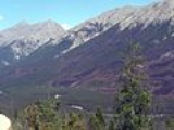
Course
Beaverfoot Range
The Beaverfoot Range is a mountain range of the Canadian Rockies, located in southeastern British Columbia. The range extends from Cedared Creek near Spillimacheen north to the Kicking Horse River.This range includes the following mountains and peaks:...
of southeastern British Columbia, and flows initially southeast through the valleys of Kootenay National Park
Kootenay National Park
Kootenay National Park is located in southeastern British Columbia Canada covering in the Canadian Rockies and forms part of a World Heritage Site. The park ranges in elevation from at the south-west park entrance to at Deltaform Mountain...
. Its first few kilometers (miles) are quiet, threading slowly through a series of marsh
Marsh
In geography, a marsh, or morass, is a type of wetland that is subject to frequent or continuous flood. Typically the water is shallow and features grasses, rushes, reeds, typhas, sedges, other herbaceous plants, and moss....
es and small lakes. The river becomes significantly enlarged as it reaches the confluence with the Vermilion River
Vermilion River (British Columbia)
Vermilion River, in Kootenay National Park headwatered at Vermilion Pass, flowing through Vermilion Valley, fed by the Simpson River, Tokumm Creek, Verendrye Creek, etc. is a major tributary of the Kootenay River....
, which is actually the larger of the two where they meet near the settlement of Kootenay Crossing. It continues southeast, receiving the Palliser River
Palliser River
The Palliser River is a tributary of the Kootenay River in the Canadian province of British Columbia. It is part of the Columbia River basin, as the Kootenay River is a tributary of the Columbia River....
from the left, and swings southwards into a gorge at the confluence with the White River.
At the small town of Canal Flats, British Columbia
Canal Flats, British Columbia
Canal Flats is a village located at the southern end of Columbia Lake, the source of the Columbia River in British Columbia, Canada. In 2006, it had a population of 700.-Location:...
it passes within 2 kilometres (1.2 mi) of Columbia Lake
Columbia Lake
Columbia Lake is the primary lake at the headwaters of the Columbia River, in British Columbia, Canada. It is fed by several small tributaries. The village of Canal Flats is located at the south end of the lake....
, the headwaters of the Columbia River, as it merges into the Rocky Mountain Trench
Rocky Mountain Trench
The Rocky Mountain Trench, or the Trench or The Valley of a Thousand Peaks, is a large valley in the northern part of the Rocky Mountains. It is both visually and cartographically a striking physiographic feature extending approximately from Flathead Lake, Montana, to the Liard River, just south...
and the eastern foothills of the Selkirk Mountains
Selkirk Mountains
The Selkirk Mountains are a mountain range spanning the northern portion of the Idaho Panhandle, eastern Washington, and southeastern British Columbia. They begin at Mica Peak near Coeur d'Alene, Idaho and extend approximately 320 km north from the border. The range is bounded on its west,...
. It receives the Lussier River
Lussier River
The Lussier River is a tributary of the Kootenay River in the Canadian province of British Columbia. It is part of the Columbia River basin, as the Kootenay River is a tributary of the Columbia River.-Course:...
near Skookumchuck Station of the Canadian Pacific Railway
Canadian Pacific Railway
The Canadian Pacific Railway , formerly also known as CP Rail between 1968 and 1996, is a historic Canadian Class I railway founded in 1881 and now operated by Canadian Pacific Railway Limited, which began operations as legal owner in a corporate restructuring in 2001...
and the St. Mary
St. Mary River (British Columbia)
The St. Mary River is a river in the East Kootenay region of British Columbia. It rises in the Purcell Mountains and flows in a generally southeasterly direction to its confluence with the Kootenay River at Fort Steele, British Columbia....
and Wild Horse
Wild Horse River
The Wild Horse River, formerly known as Wild Horse Creek, is a tributary of the Kootenay River, joining it near the town of Fort Steele, British Columbia, Canada. The river's canyon was the setting for the Wild Horse Creek Gold Rush and associated "war" during the gold rush of the mid-1860s.-Gold...
rivers at the historic mining town of Fort Steele, then the Bull River
Bull River (British Columbia)
The Bull River is a long tributary of the Kootenay River in the Canadian province of British Columbia. It is part of the Columbia River basin, as the Kootenay River is a tributary of the Columbia River.-Course:...
at the settlement of the same name. At Wardner, British Columbia, the Kootenay widens into the Lake Koocanusa
Lake Koocanusa
Lake Koocanusa is a reservoir in British Columbia and Montana formed by the damming of the Kootenai River by the Libby Dam in 1975....
reservoir, formed by Libby Dam
Libby Dam
Libby Dam is a dam on the Kootenai River in the U.S. state of Montana.Dedicated on August 24, 1975, Libby Dam spans the Kootenai River upstream from the town of Libby, Montana. Libby Dam is tall and long. Lake Koocanusa is the name of the reservoir behind the dam; it extends upriver from...
over 130 kilometres (80.8 mi) downstream at Jennings, Montana. Lake Koocanusa, fed by the Elk River
Elk River (British Columbia)
The Elk River is a long river, in the southeastern Kootenay district of the Canadian province of British Columbia. Its drainage basin is in area. Its mean discharge is approximately 60 m³/s, with a maximum recorded discharge of 818 m³/s.-Course:...
(one of the Kootenay's larger tributaries) spans the U.S.-Canada border.
Below Libby Dam the river, now known as the Kootenai, surges around the south side of the Purcell Mountains
Purcell Mountains
The Purcell Mountains are a mountain range in southeastern British Columbia, Canada. They are a subrange of the Columbia Mountains, which includes the Selkirk, Monashee, and Cariboo Mountains. They are located on the west side of the Rocky Mountain Trench in the area of the Columbia Valley, and on...
in what is known as the Big Bend, where it receives the Fisher River
Fisher River (Montana)
The Fisher River is a tributary of the Kootenay River in the U.S. state of Montana. The Fisher River properly begins at the confluence of its two main tributaries, the Pleasant Valley Fisher River and the Silver Butte Fisher River...
from the left and veers to the west, passing the city of Libby
Libby, Montana
Libby is a city in and the county seat of Lincoln County, Montana, United States. The population was 2,626 at the 2000 census.-Geography:Libby is located at , along U.S. Route 2....
. The Kootenai then drops over Kootenai Falls in a gorge, and veers northwest at the town of Troy
Troy, Montana
Troy is a city in Lincoln County, Montana, United States. The population was 957 at the 2000 census.-Geography:Troy is located at ....
. The Yaak River
Yaak River
The Yaak River is a tributary of the Kootenay River in the U.S. state of Montana and the Canadian province of British Columbia.-Course:...
and Moyie River
Moyie River
The Moyie River is a tributary of the Kootenai River in the U.S. state of Idaho and the Canadian province of British Columbia. The Moyie River is part of the Columbia River basin, being a tributary of the Kootenay River, which is tributary to the Columbia River.-Course:The Moyie River originates...
join from the north, the latter near the village of Moyie Springs
Moyie Springs, Idaho
Moyie Springs is a city in Boundary County, Idaho, United States. The population was 718 at the 2010 census.-Geography:Moyie Springs is located at ....
, before and after the Kootenai crosses the Montana-Idaho state line. In Idaho the Kootenai's current slows significantly as it enters the Kootenai Valley, passing the city of Bonners Ferry
Bonners Ferry, Idaho
Bonners Ferry is a city in and the county seat of Boundary County, Idaho, United States. The population was 2,543 at the 2010 census.-History:...
, where it turns north.
The Kootenai re-enters Canada and becomes the Kootenay again south of Creston, British Columbia
Creston, British Columbia
Creston is a town of 4,826 people in the Kootenay region of southeastern British Columbia, Canada. The town is located just a few kilometers north of the Porthill, Idaho border crossing into the United States and about a three-hour drive north from Spokane, Washington. It is about a one-hour drive...
, and slows as it enters the Kootenay Flats before broadening into 100 kilometres (62.1 mi)-long Kootenay Lake
Kootenay Lake
Kootenay Lake is a lake located in British Columbia, Canada and is part of theKootenay River. The lake has been raised by the Corra Linn Dam and has a dike system at the southern end, which, along with industry in the 1950s-70s, has changed the ecosystem in and around the water...
, where the Duncan River
Duncan River
The Duncan River is a long river in the Canadian province of British Columbia. Its drainage basin is in area. It is part of the Columbia River basin, being tributary via Kootenay Lake to the Kootenay River, which is a tributary of the Columbia River...
, the largest tributary, contributes its waters. Near Balfour
Balfour, British Columbia
Balfour, also known as Balfour Bay, is an unincorporated community in British Columbia, located about northeast of the city of Nelson and located at the juncture of Kootenay Lake with its West Arm....
an arm of the lake branches westwards into canyons near Nelson
Nelson, British Columbia
Nelson is a city located in the Selkirk Mountains on the extreme West Arm of Kootenay Lake in the Southern Interior of British Columbia, Canada. Known as "The Queen City", and acknowledged for its impressive collection of restored heritage buildings from its glory days in a regional silver rush,...
, where below Corra Linn Dam
Corra Linn Dam
Corra Linn Dam is a concrete hydroelectric dam on the Kootenay River in the Canadian province of British Columbia. It is located where the West Arm Kootenay Lake flows into the Kootenay River. The dam's powerplant has a generating capacity of 49 MW. The dam was formerly owned by West Kootenay Power...
the Kootenay becomes a river again, but not for long. The river drops over several waterfalls at Bonnington falls, all of which are taken advantaged of to generate hydropower. Four run-of-the river dams
Run-of-the-river hydroelectricity
Run-of-the-river hydroelectricity is a type of hydroelectric generation whereby a considerably smaller water storage called pondage or none is used to supply a power station. Run-of-the-river power plants are classified as with or without pondage...
impound the river in the 22 kilometres (13.7 mi) stretch that follows. At Brilliant
Brilliant, British Columbia
Brilliant is a settlement in British Columbia....
it widens into a small inland delta
River delta
A delta is a landform that is formed at the mouth of a river where that river flows into an ocean, sea, estuary, lake, reservoir, flat arid area, or another river. Deltas are formed from the deposition of the sediment carried by the river as the flow leaves the mouth of the river...
, then at Castlegar
Castlegar, British Columbia
Castlegar is the second largest city in the West Kootenay region of British Columbia, Canada. It is located within the Selkirk Mountains at the confluence of the Kootenay and Columbia Rivers. It is a regional trade and transportation centre, with a local economy fueled by forestry, mining and tourism...
it joins with the Columbia River.
Watershed
At 50298 square kilometres (19,420.2 sq mi) in size, the Kootenay river's watershedDrainage basin
A drainage basin is an extent or an area of land where surface water from rain and melting snow or ice converges to a single point, usually the exit of the basin, where the waters join another waterbody, such as a river, lake, reservoir, estuary, wetland, sea, or ocean...
is one of the largest sub-basins of the Columbia Basin
Columbia Basin
The Columbia Basin, the drainage basin of the Columbia River, occupies a large area–about —of the Pacific Northwest region of North America. In common usage, the term often refers to a smaller area, generally the portion of the drainage basin that lies within eastern Washington.Usage of the term...
. Its drainage basin encompasses an area almost 400 kilometres (248.5 mi) from north to south and 250 kilometres (155.3 mi) from east to west, roughly defining a region of the Pacific Northwest
Pacific Northwest
The Pacific Northwest is a region in northwestern North America, bounded by the Pacific Ocean to the west and, loosely, by the Rocky Mountains on the east. Definitions of the region vary and there is no commonly agreed upon boundary, even among Pacific Northwesterners. A common concept of the...
known as the Kootenays
Kootenays
The Kootenay Region comprises the southeastern portion of British Columbia. It takes its name from the Kootenay River, which in turn was named for the Ktunaxa First Nation first encountered by explorer David Thompson.-Boundaries:The Kootenays are more or less defined by the Kootenay Land...
. The term "Kootenays" is loosely defined and refers to the whole region of the central Rockies
Rocky Mountains
The Rocky Mountains are a major mountain range in western North America. The Rocky Mountains stretch more than from the northernmost part of British Columbia, in western Canada, to New Mexico, in the southwestern United States...
, Selkirks
Selkirk Mountains
The Selkirk Mountains are a mountain range spanning the northern portion of the Idaho Panhandle, eastern Washington, and southeastern British Columbia. They begin at Mica Peak near Coeur d'Alene, Idaho and extend approximately 320 km north from the border. The range is bounded on its west,...
and Purcells
Purcell Mountains
The Purcell Mountains are a mountain range in southeastern British Columbia, Canada. They are a subrange of the Columbia Mountains, which includes the Selkirk, Monashee, and Cariboo Mountains. They are located on the west side of the Rocky Mountain Trench in the area of the Columbia Valley, and on...
(Percells in the U.S.) in southeastern British Columbia (BC), and does not necessarily mean the area drained by the river in Canada. (Across the U.S. border, the moniker no longer applies.) Over 70 percent of the Kootenay's watershed is in Canada while the Montana and Idaho portions occupy 23 and 6%, respectively. The Kootenay is one of the few major rivers in North America that begin in one country, cross into another, and return to the first—others include the Milk River
Milk River (Montana-Alberta)
The Milk River is a tributary of the Missouri River, long, in the United States state of Montana and the Canadian province of Alberta. Rising in the Rocky Mountains, the river drains a sparsely populated, semi-arid watershed of , ending just east of Fort Peck, Montana.-Geography:It is formed in...
, a tributary of the Missouri River
Missouri River
The Missouri River flows through the central United States, and is a tributary of the Mississippi River. It is the longest river in North America and drains the third largest area, though only the thirteenth largest by discharge. The Missouri's watershed encompasses most of the American Great...
; the Souris River
Souris River
The Souris River or Mouse River is a river in central North America. It is about 700 km in length and drains about . It rises in the Yellow Grass Marshes north of Weyburn, Saskatchewan...
, a tributary of the Assiniboine River
Assiniboine River
The Assiniboine River is a river that runs through the prairies of Western Canada in Saskatchewan and Manitoba. It is a tributary of the Red River. The Assiniboine is a typical meandering river with a single main channel embanked within a flat, shallow valley in some places and a steep valley in...
; and the Kettle River
Kettle River (Columbia River)
The Kettle River is a tributary of the Columbia River in northeastern Washington in the United States and southeastern British Columbia in Canada. Its drainage basin is large, of which are in Canada and in the United States.-Course:...
, a tributary of the Columbia River. It is the third largest tributary of the Columbia by drainage basin and discharge.

Kootenay Lake
Kootenay Lake is a lake located in British Columbia, Canada and is part of theKootenay River. The lake has been raised by the Corra Linn Dam and has a dike system at the southern end, which, along with industry in the 1950s-70s, has changed the ecosystem in and around the water...
and in parts of the Rocky Mountain Trench from Canal Flats
Canal Flats, British Columbia
Canal Flats is a village located at the southern end of Columbia Lake, the source of the Columbia River in British Columbia, Canada. In 2006, it had a population of 700.-Location:...
to Lake Koocanusa
Lake Koocanusa
Lake Koocanusa is a reservoir in British Columbia and Montana formed by the damming of the Kootenai River by the Libby Dam in 1975....
. Mountain ranges in the region generally trend from northwest to southeast and define drainage patterns with their steep and dramatic vertical relief, with the exception of the Kootenay itself which cuts westwards at its southern bend. Of the Kootenay's many tributaries, the 206 kilometres (128 mi)-long Duncan River
Duncan River
The Duncan River is a long river in the Canadian province of British Columbia. Its drainage basin is in area. It is part of the Columbia River basin, being tributary via Kootenay Lake to the Kootenay River, which is a tributary of the Columbia River...
is the largest. Hundreds of other tributaries join the river in its winding course, including the Vermilion
Vermilion River (British Columbia)
Vermilion River, in Kootenay National Park headwatered at Vermilion Pass, flowing through Vermilion Valley, fed by the Simpson River, Tokumm Creek, Verendrye Creek, etc. is a major tributary of the Kootenay River....
, Cross
Cross River (British Columbia)
The Cross River is a tributary of the Kootenay River in the Canadian province of British Columbia. It is part of the Columbia River basin, as the Kootenay River is tributary to the Columbia River....
, Palliser
Palliser River
The Palliser River is a tributary of the Kootenay River in the Canadian province of British Columbia. It is part of the Columbia River basin, as the Kootenay River is a tributary of the Columbia River....
, White
White River (British Columbia)
The White River is a major headwaters tributary of the Kootenay River in southeastern British Columbia, Canada. The river is long and drains an isolated area of the Canadian Rockies east of the village of Canal Flats....
, Wild Horse
Wild Horse River
The Wild Horse River, formerly known as Wild Horse Creek, is a tributary of the Kootenay River, joining it near the town of Fort Steele, British Columbia, Canada. The river's canyon was the setting for the Wild Horse Creek Gold Rush and associated "war" during the gold rush of the mid-1860s.-Gold...
, St. Mary
St. Mary River (British Columbia)
The St. Mary River is a river in the East Kootenay region of British Columbia. It rises in the Purcell Mountains and flows in a generally southeasterly direction to its confluence with the Kootenay River at Fort Steele, British Columbia....
, Elk
Elk River (British Columbia)
The Elk River is a long river, in the southeastern Kootenay district of the Canadian province of British Columbia. Its drainage basin is in area. Its mean discharge is approximately 60 m³/s, with a maximum recorded discharge of 818 m³/s.-Course:...
, Fisher
Fisher River (Montana)
The Fisher River is a tributary of the Kootenay River in the U.S. state of Montana. The Fisher River properly begins at the confluence of its two main tributaries, the Pleasant Valley Fisher River and the Silver Butte Fisher River...
, Yaak
Yaak River
The Yaak River is a tributary of the Kootenay River in the U.S. state of Montana and the Canadian province of British Columbia.-Course:...
, Moyie
Moyie River
The Moyie River is a tributary of the Kootenai River in the U.S. state of Idaho and the Canadian province of British Columbia. The Moyie River is part of the Columbia River basin, being a tributary of the Kootenay River, which is tributary to the Columbia River.-Course:The Moyie River originates...
, Goat, and Slocan
Slocan River
The Slocan River is a long tributary of the Kootenay River in the Canadian province of British Columbia. It is part of the Columbia River basin, as the Kootenay River is a tributary of the Columbia River...
rivers.
Many river basins border on the Kootenay—some are part of the Columbia Basin, while others drain to distant shores of the North American continent. On the south and southeast, the divide formed by the Cabinet and Whitefish ranges separate the Kootenay and Flathead River
Flathead River
The Flathead River, in the northwestern part of the U.S. state of Montana, originates in the Rocky Mountains near Glacier National Park and flows southwest into Flathead Lake, then after a journey of , empties into the Clark Fork. The river is part of the Columbia River drainage basin, as the Clark...
watersheds. The Flathead is a tributary of the Clark Fork River-Pend Oreille River
Pend Oreille River
The Pend Oreille River is a tributary of the Columbia River, approximately long, in northern Idaho and northeastern Washington in the United States, as well as southeastern British Columbia in Canada. In its passage through British Columbia its name is spelled Pend-d'Oreille River...
system which borders the Kootenay watershed on the southwest. The upper Columbia River basin forms the boundary on the north, and the Kicking Horse River
Kicking Horse River
The Kicking Horse River is a river located in the Canadian Rockies of southeastern British Columbia, Canada.The river was named in 1858, when James Hector, a member of the Palliser Expedition, was kicked by his packhorse while exploring the river. Hector survived and named the river and the...
watershed also borders the north side of the Kootenay basin. To the southwest is the Priest River
Priest River (Idaho)
The Priest River is a tributary of the Pend Oreille River in the U.S. state of Idaho. It is part of the Columbia River basin, as the Pend Oreille River is a tributary of the Columbia River. The river's drainage basin is in area.-Course:...
, a Pend Oreille tributary. On the east side, over the Continental Divide, the Bow River
Bow River
The Bow River is a river in the Canadian province of Alberta. It is a tributary of the South Saskatchewan River, and is considered the headwater of the Nelson River....
and Oldman River
Oldman River
The Oldman River is a river in southern Alberta, Canada. It flows roughly west to east from the Rocky Mountains, through the communities of Fort Macleod, Lethbridge, Taber, and on to Grassy Lake, where it joins with the Bow River to form the South Saskatchewan River, which eventually drains into...
take rise. Both are tributaries of the South Saskatchewan River
South Saskatchewan River
The South Saskatchewan River is a major river in Canada that flows through the provinces of Alberta and Saskatchewan....
, which is part of the Hudson Bay
Hudson Bay
Hudson Bay , sometimes called Hudson's Bay, is a large body of saltwater in northeastern Canada. It drains a very large area, about , that includes parts of Ontario, Quebec, Saskatchewan, Alberta, most of Manitoba, southeastern Nunavut, as well as parts of North Dakota, South Dakota, Minnesota,...
drainage basin.
Geology
The geologic story of the Kootenay is strongly connected to the geology of the Columbia, Selkirk and Rocky Mountains. The mountains in much of the Kootenay River catchment are composed of PrecambrianPrecambrian
The Precambrian is the name which describes the large span of time in Earth's history before the current Phanerozoic Eon, and is a Supereon divided into several eons of the geologic time scale...
sedimentary rock
Sedimentary rock
Sedimentary rock are types of rock that are formed by the deposition of material at the Earth's surface and within bodies of water. Sedimentation is the collective name for processes that cause mineral and/or organic particles to settle and accumulate or minerals to precipitate from a solution....
of the Belt Supergroup
Belt Supergroup
The Belt Supergroup, is an assemblage of Mesoproterozoic sedimentary rocks which outcrop chiefly in western Montana, but also exposed in Idaho, Washington, Wyoming, and British Columbia. It is most famous as the formation that makes up Glacier National Park in northwest Montana...
, in turn stratified into several subgroups with slightly different characteristics and ages.
However, most of the rocks have one thing in common; the rocks are generally hard and erosion-resistant. The Rocky Mountain Trench is thought to be a partial graben
Graben
In geology, a graben is a depressed block of land bordered by parallel faults. Graben is German for ditch. Graben is used for both the singular and plural....
, or a long narrow strip of land that has dropped in elevation over time because of parallel faults on both sides. Faults in the Kootenay River watershed trend north-northwest to south-southeast as is common in much of British Columbia. The underlying rock is generally stable and contains more outcroppings of metamorphic
Metamorphic rock
Metamorphic rock is the transformation of an existing rock type, the protolith, in a process called metamorphism, which means "change in form". The protolith is subjected to heat and pressure causing profound physical and/or chemical change...
and igneous rock
Igneous rock
Igneous rock is one of the three main rock types, the others being sedimentary and metamorphic rock. Igneous rock is formed through the cooling and solidification of magma or lava...
as one progresses westwards. Formations of Cambrian
Cambrian
The Cambrian is the first geological period of the Paleozoic Era, lasting from Mya ; it is succeeded by the Ordovician. Its subdivisions, and indeed its base, are somewhat in flux. The period was established by Adam Sedgwick, who named it after Cambria, the Latin name for Wales, where Britain's...
and Devonian
Devonian
The Devonian is a geologic period and system of the Paleozoic Era spanning from the end of the Silurian Period, about 416.0 ± 2.8 Mya , to the beginning of the Carboniferous Period, about 359.2 ± 2.5 Mya...
rock also appear in small amounts in the U.S. portion of the Kootenay.
Bedrock
Bedrock
In stratigraphy, bedrock is the native consolidated rock underlying the surface of a terrestrial planet, usually the Earth. Above the bedrock is usually an area of broken and weathered unconsolidated rock in the basal subsoil...
composes much of the streambed in the upper and lower reaches of the Kootenay, but in the middle portion, alluvial sediments allow the river to meander
Meander
A meander in general is a bend in a sinuous watercourse. A meander is formed when the moving water in a stream erodes the outer banks and widens its valley. A stream of any volume may assume a meandering course, alternately eroding sediments from the outside of a bend and depositing them on the...
over a broader valley floor. The sediments probably originated through heavy glaciation
Glacier
A glacier is a large persistent body of ice that forms where the accumulation of snow exceeds its ablation over many years, often centuries. At least 0.1 km² in area and 50 m thick, but often much larger, a glacier slowly deforms and flows due to stresses induced by its weight...
during the previous Ice Age
Ice age
An ice age or, more precisely, glacial age, is a generic geological period of long-term reduction in the temperature of the Earth's surface and atmosphere, resulting in the presence or expansion of continental ice sheets, polar ice sheets and alpine glaciers...
. About 15,000 years ago, the Cordilleran Ice Sheet
Cordilleran Ice Sheet
The Cordilleran ice sheet was a major ice sheet that covered, during glacial periods of the Quaternary, a large area of North America. This included the following areas:*Western Montana*The Idaho Panhandle...
advanced southwards into present-day BC, Montana and Idaho, blocking the Kootenay River at the outlet of Kootenay Lake, which did not yet exist. Glaciers covered most of the northern Kootenay River watershed and heavily shaped the peaks and valleys one sees today. The glacier that formed Kootenay Lake caused the river to back up into an enormous body of water that stretched all the way to Libby, Montana
Libby, Montana
Libby is a city in and the county seat of Lincoln County, Montana, United States. The population was 2,626 at the 2000 census.-Geography:Libby is located at , along U.S. Route 2....
, near where the Libby Dam now stands, and possibly even connected to Lake Pend Oreille
Lake Pend Oreille
Lake Pend Oreille is a lake in the northern Idaho Panhandle, with a surface area of . It is 65 miles long, and 1,150 feet deep in some regions, making it the fifth deepest in the United States. It is fed by the Clark Fork River and the Pack River, and drains via the Pend Oreille River...
, which also was much enlarged at the time. Glacially deposited sediments buried the old streambed of the Kootenay River and created a natural dam where the Kootenay turns west out of Kootenay Lake. After the glaciers retreated, Kootenay Lake receded to its present level and the Kootenay Flats were formed.
History
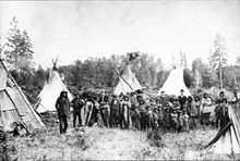
First inhabitants
The first peoples of the Kootenay River valley were the Ktunaxa people (often referred to as Kootenai) from whom the river's name derives. Ktunaxa creation myths state that their people were created by the Quilxka Nupika (supreme being) and have always lived in the region; one reads "I have created you Kootenai people to look after this beautiful land, to honor and guard and celebrate my Creation here.” However, many historians believe that they are descended from Great PlainsGreat Plains
The Great Plains are a broad expanse of flat land, much of it covered in prairie, steppe and grassland, which lies west of the Mississippi River and east of the Rocky Mountains in the United States and Canada. This area covers parts of the U.S...
tribes that were driven out of their historic territory by the Blackfeet
Blackfeet
The Piegan Blackfeet are a tribe of Native Americans of the Algonquian language family based in Montana, having lived in this area since around 6,500 BC. Many members of the tribe live as part of the Blackfeet Nation in northwestern Montana, with population centered in Browning...
in the 16th century. The Ktunaxa are considered quite isolated from other Pacific Northwest and Great Plains tribes. Their languate is an "isolate", which is only distantly related (if at all) to the Salishan languages
Salishan languages
The Salishan languages are a group of languages of the Pacific Northwest...
spoken by tribes of the Lake Pend d'-Oreille area. They were semi-nomadic people and inhabited a large area of the Kootenay valley from the headwaters to Kootenay Lake. Four villages provided their shelter in the winter, while in the rest of the year, they traveled between fishing, hunting and berry-picking areas. The northern Ktunaxa hunted buffalo
American Bison
The American bison , also commonly known as the American buffalo, is a North American species of bison that once roamed the grasslands of North America in massive herds...
, while the southerners mainly fished. Notably, the Ktunaxa were the first tribe west of the Rockies to capture and use feral European-introduced horses for their own use.
The origin and meaning of the name "Kootenai" is uncertain. Prior to the arrival of Europeans, they were known as Ksanka, "people of the standing arrow". It is thought that French-Canadian fur trappers of the Hudson's Bay Company
Hudson's Bay Company
The Hudson's Bay Company , abbreviated HBC, or "The Bay" is the oldest commercial corporation in North America and one of the oldest in the world. A fur trading business for much of its existence, today Hudson's Bay Company owns and operates retail stores throughout Canada...
and other companies in the early 19th century were the first refer to them as Kootenai, which means "water people" in an Algonquian
Algonquian languages
The Algonquian languages also Algonkian) are a subfamily of Native American languages which includes most of the languages in the Algic language family. The name of the Algonquian language family is distinguished from the orthographically similar Algonquin dialect of the Ojibwe language, which is a...
language. It may also mean "deer robes," referring to their excellent skill for hunting deer. In some written records from the early 19th century, also by the French, the Ktunaxa were sometimes called the Flatbows (Arcs plats) and the river called the Flatbow River. Other inhabitants of the area included the Montana Salish (in the south) and Shuswap
Secwepemc
The Secwepemc , known in English as the Shuswap people, are a First Nations people residing in the Canadian province of British Columbia. Their traditional territory ranges from the eastern Chilcotin Plateau and the Cariboo Plateau southeast through the Thompson Country to Kamloops and the Shuswap...
(in the north), but these tribes were mostly not on the main river.
Exploration
David Thompson (explorer)
David Thompson was an English-Canadian fur trader, surveyor, and map-maker, known to some native peoples as "Koo-Koo-Sint" or "the Stargazer"...
set out from Saskatchewan
Saskatchewan
Saskatchewan is a prairie province in Canada, which has an area of . Saskatchewan is bordered on the west by Alberta, on the north by the Northwest Territories, on the east by Manitoba, and on the south by the U.S. states of Montana and North Dakota....
to find the source of the Columbia. He crossed over the Canadian Rockies
Canadian Rockies
The Canadian Rockies comprise the Canadian segment of the North American Rocky Mountains range. They are the eastern part of the Canadian Cordillera, extending from the Interior Plains of Alberta to the Rocky Mountain Trench of British Columbia. The southern end borders Idaho and Montana of the USA...
through Howse Pass and eventually arrived on the banks of the Kootenay, which he thought to be the Columbia. Thompson traveled down the river a ways but turned back when he was attacked by Native Americans. The following year, Thompson, his family, and several men made another attempt at finding the Columbia. They crossed over the Rockies at a more northerly spot and traveled down the Blaeberry River
Blaeberry River
The Blaeberry River is a tributary of the Columbia River in the Columbia Country of British Columbia, Canada, rising in the Canadian Rockies on the south side of Howse Pass and joining the Columbia midway between the town of Golden, at the confluence of the Kicking Horse River, and the east foot of...
to the Columbia, eventually discovering Columbia Lake and establishing there the trading post Kootenae House. In the spring of 1808, he set off down the Kootenay River, this time reaching present-day Montana and Idaho where he established Kullyspell House
Kullyspell House
Kullyspell House was a fur trading post established in 1809 on Lake Pend Oreille in what is now North Idaho...
and Saleesh House
Saleesh House
Saleesh House, also known as Flathead Post, was a North West Company fur trading post built near present-day Thompson Falls, Montana in 1809 by David Thompson and James McMillan of the North West Company. It became a Hudson's Bay Company post after that company absorbed the North West Company....
, trading posts on Lake Pend Oreille
Lake Pend Oreille
Lake Pend Oreille is a lake in the northern Idaho Panhandle, with a surface area of . It is 65 miles long, and 1,150 feet deep in some regions, making it the fifth deepest in the United States. It is fed by the Clark Fork River and the Pack River, and drains via the Pend Oreille River...
and the Clark Fork
Clark Fork (river)
The Clark Fork is a river in the U.S. states of Montana and Idaho, approximately long. The largest river by volume in Montana, it drains an extensive region of the Rocky Mountains in western Montana and northern Idaho in the watershed of the Columbia River, flowing northwest through a long...
, respectively. After spending a winter in Montana, he tried to reach the Columbia by traveling down the Pend Oreille River
Pend Oreille River
The Pend Oreille River is a tributary of the Columbia River, approximately long, in northern Idaho and northeastern Washington in the United States, as well as southeastern British Columbia in Canada. In its passage through British Columbia its name is spelled Pend-d'Oreille River...
but failed in this attempt, eventually returning to Kootenae House via the Kootenay River northwards the following spring.
Through the early 19th century, Thompson continued to trade furs throughout the Kootenay region for the North West Company
North West Company
The North West Company was a fur trading business headquartered in Montreal from 1779 to 1821. It competed with increasing success against the Hudson's Bay Company in what was to become Western Canada...
, and for the few years when he had a total monopoly
Monopoly
A monopoly exists when a specific person or enterprise is the only supplier of a particular commodity...
over the Canadian fur trade west of the Rockies, he outlawed alcoholic drinks altogether. He was known to have written "I had made it a law to myself that no alcohol should pass the mountains in my company". When two of Thompson's trading partners tried to make him take two barrels of rum to Kootanae House, Thompson "placed the two kegs on a vicious horse and by noon the kegs were empty and in pieces, the horse rubbing his load against the rocks to get rid of it … I told them what I had done, and that I would do the same to every keg of alcohol." Of course, wine, beer, rum and other intoxicating drinks were imported in time.
John Palliser
John Palliser
John Palliser was an Irish-born geographer and explorer. Born in Dublin, Ireland, he was the son of Colonel Wray Palliser and a brother of Major Sir William Palliser , all descendants of Dr William Palliser, Archbishop of Cashel .From 1839 to 1863, Palliser served in the Waterford Militia,...
crossed the Rockies through a pass in 1858 that led to the headwaters of the Palliser River
Palliser River
The Palliser River is a tributary of the Kootenay River in the Canadian province of British Columbia. It is part of the Columbia River basin, as the Kootenay River is a tributary of the Columbia River....
, a tributary of the Kootenay River now named in his honor. (However, at first, his party referred to it as Palliser's River.) His expedition made it downstream to Columbia Lake, but had some trouble making their way back to Alberta; the return route that they had chosen proved too dangerous to negotiate. After trading for some horses and new supplies from a band of Ktunaxa, they made it back over the Rockies later that year through North Kootenay Pass near Lower
Lower Kananaskis Lake
Lower Kananaskis Lake is a natural lake that was turned into a reservoir in Kananaskis Country in Alberta, Canada.Lower Kananaskis Lake is in Peter Lougheed Provincial Park along with the Upper Kananaskis Lake....
and Upper Kananaskis Lake
Upper Kananaskis Lake
Upper Kananaskis Lake is a natural lake that was turned into a reservoir in Kananaskis Country in Alberta, Canada.Upper Kananaskis Lake is located in Peter Lougheed Provincial Park along with the Lower Kananaskis Lake....
s, after traveling up the Elk River
Elk River (British Columbia)
The Elk River is a long river, in the southeastern Kootenay district of the Canadian province of British Columbia. Its drainage basin is in area. Its mean discharge is approximately 60 m³/s, with a maximum recorded discharge of 818 m³/s.-Course:...
.
The series of expeditions he would later lead through 1859 were to be known as the Palliser Expeditions, or officially, the British North American Exploring Expedition, which although involved some travel west of the Rockies, was mostly limited to the east side of the Continental Divide
Continental Divide
The Continental Divide of the Americas, or merely the Continental Gulf of Division or Great Divide, is the name given to the principal, and largely mountainous, hydrological divide of the Americas that separates the watersheds that drain into the Pacific Ocean from those river systems that drain...
. Palliser's earlier travels were credited for being a "vital forerunner to the European settlement of the Prairies [of central Canada], providing volumes of information on the resources of this vast region."
In September 1859, Palliser traveled into the Kootenay River valley to find a suitable path for a trade route and possibly a railroad. Instead of crossing the Rockies, as Thompson did, Palliser set out from Fort Colville
Fort Colville
The trade center Fort Colville was built by the Hudson's Bay Company at Kettle Falls on the Columbia River, a few miles west of the present site of Colville, Washington in 1825, to replace Spokane House as a regional trading center, as the latter was deemed to be too far from the Columbia River...
, a Hudson's Bay Company trading post near Kettle Falls
Kettle Falls
Kettle Falls was an ancient and important salmon fishing site on the upper reaches of the Columbia River, in what is today the U.S. state of Washington, near the Canadian border...
on the Columbia River. He then proceeded up the Pend Oreille River (noted as 'Pendoreilles') and crossed into the Kootenay River valley, which in his records was either the "Kootanie" or "Flat Bow River". Kootenay Lake was called "Flat Bow Lake". Palliser was told by Ktunaxa tribal members that a trail already existed along the Kootenay River, terminating at Columbia Lake, but was in decrepit condition (having being out of use for many years) and "entirely impracticable for horses". They re-blazed the trail for many miles and returned to Kootenay Lake by mid-October of the same year. The expedition's findings were later to become important transportation routes through the Rockies to the Kootenays area, and the trail that they followed later became the route of the Canadian Pacific Railway
Canadian Pacific Railway
The Canadian Pacific Railway , formerly also known as CP Rail between 1968 and 1996, is a historic Canadian Class I railway founded in 1881 and now operated by Canadian Pacific Railway Limited, which began operations as legal owner in a corporate restructuring in 2001...
.
Gold and silver boom
Wild Horse River
The Wild Horse River, formerly known as Wild Horse Creek, is a tributary of the Kootenay River, joining it near the town of Fort Steele, British Columbia, Canada. The river's canyon was the setting for the Wild Horse Creek Gold Rush and associated "war" during the gold rush of the mid-1860s.-Gold...
and Kootenay Rivers in the East Kootenay region resulted in the Wild Horse Gold Rush
British Columbia Gold Rushes
The presence of gold in the region that is now British Columbia is mentioned in old legends that, in part, led to its discovery. The Strait of Anian, claimed to have been sailed by Juan de Fuca for whom today's Strait of Juan de Fuca is named, was described as passing through a land "rich in gold,...
in which between three and ten thousand men descended upon the area and the gold rush town of Fisherville
Fisherville, British Columbia
Fisherville is a classic example of a boom and bust gold rush town that characterized the 1860s in British Columbia. Gold was discovered here in 1864...
was built; it had to be moved when it was discovered the town sat atop some of the richest deposits. Originally, the river (and the area) were known as "Stud Horse" by the early miners, but government officials changed it to Wild Horse. The new town's site was officially named Kootenai (though still known as Fisherville), also spelled Kootenay and Koutenais and also known as Wild Horse. Galbraith's Ferry was established across the Kootenay near Fort Steele to facilitate crossing by the incoming rush of prospectors and merchants. Most of the gold was mined out by 1864, in June of which one American prospector wrote that some 200 miners were arriving each day. By 1865 the peak of the rush was over and the diggings had been found not as rich as previously believed when news arrived in 1865 of the strikes in the Big Bend of the Columbia
Big Bend Country
Big Bend Country is a term used in the Canadian province of British Columbia to refer to the region around the northernmost bend of the Columbia River, where the river leaves its initial northwestward course along the Rocky Mountain Trench to curve around the northern end of the Selkirk Mountains...
and the bulk of the mining population moved there en masse.
Fisherville, which had a Hudson's Bay post and other businesses, continued on with a few hundred residents for a few years (most of them Chinese by the end, as was the case with many other BC gold towns also) but was eclipsed as a supply centre with the creation of nearby Fort Steele. The Chinese miners continued to work the "played-out" claims abandoned by American and Canadian miners, taking what little gold was left. Fisherville eventually was abandoned, its buildings left to ruin, and little remains of the settlement today. Other gold rushes on the Moyie and Goat Rivers, tributaries of the Kootenay, were followed by the discovery of silver and galena
Galena
Galena is the natural mineral form of lead sulfide. It is the most important lead ore mineral.Galena is one of the most abundant and widely distributed sulfide minerals. It crystallizes in the cubic crystal system often showing octahedral forms...
mines in the Kootenay Lake and Slocan Valley areas (Silvery Slocan), leading rapidly to the settlement of the region and the creation of various "silver city" boomtowns, notably Nelson
Nelson, British Columbia
Nelson is a city located in the Selkirk Mountains on the extreme West Arm of Kootenay Lake in the Southern Interior of British Columbia, Canada. Known as "The Queen City", and acknowledged for its impressive collection of restored heritage buildings from its glory days in a regional silver rush,...
, at the outlet of Kootenay Lake, Kaslo
Kaslo, British Columbia
Kaslo is a village in the West Kootenay region of British Columbia, Canada, located on the west shore of Kootenay Lake. Known for its great natural beauty, it is a member municipality of the Central Kootenay Regional District...
, midway up its north arm, New Denver, Silverton
Silverton, British Columbia
Silverton is a village in the Slocan Valley area of the West Kootenay region of southeastern British Columbia, Canada. It is located on the eastern shore of Slocan Lake south of New Denver. It is British Columbia's smallest municipality in both population and area....
, Slocan City
Slocan, British Columbia
The Village of Slocan, commonly known as Slocan City, is a village in the Slocan Valley of the West Kootenay region of the southeastern Interior of British Columbia, Canada...
and Sandon
Sandon, British Columbia
Sandon is a ghost town in British Columbia, Canada. It is also the birthplace of hockey Hall of Fame member Cecil "Tiny" Thompson.-Location:Sandon is located in the Selkirk Mountains, about ten kilometers east of the town of New Denver.-History:...
in the 1880s and 1890s. By 1889, a smelter had been constructed close to the mouth of the Kootenay, near Revelstoke
Revelstoke, British Columbia
Revelstoke is a city in southeastern British Columbia, Canada. It is located east of Vancouver, and west of Calgary, Alberta. The city is situated on the banks of the Columbia River just south of the Revelstoke Dam and near its confluence with the Illecillewaet River...
, to process ore from the mines. Serving the mines and settlers, steamer companies plied the Kootenai River from Bonner's Ferry, Idaho to Nelson and to the Lardeau
Lardeau
Lardeau, originally spelled Lardo, is an unincorporated community and former mining town near the north end of Kootenay Lake in the West Kootenay region of southeastern British Columbia, Canada...
or "Lardo" district at the north end of Kootenay Lake, and also on the upper Kootenay River between the Cranbrook-Fort Steele area and points in Montana.
Steamboats
_at_jennings_montana_ca_1900.jpg)
When the Canadian Pacific Railway
Canadian Pacific Railway
The Canadian Pacific Railway , formerly also known as CP Rail between 1968 and 1996, is a historic Canadian Class I railway founded in 1881 and now operated by Canadian Pacific Railway Limited, which began operations as legal owner in a corporate restructuring in 2001...
(CPR) finished its transcontinental line across southern British Columbia, steamboat
Steamboat
A steamboat or steamship, sometimes called a steamer, is a ship in which the primary method of propulsion is steam power, typically driving propellers or paddlewheels...
s began to ply the upper Columbia and Kootenay Rivers, carrying passengers, produce, ore, and other trade items through the region to be distributed via the CPR's line at Golden
Golden, British Columbia
Golden is a town in southeastern British Columbia, Canada, located west of Calgary, Alberta and east of Vancouver.-History:Much of the town's history is tied into the Canadian Pacific Railway and the logging industry...
. The total run was about 500 kilometres (310.7 mi) long, ranging from Golden to the north to Jennings, Montana in the south, with a portage
Portage
Portage or portaging refers to the practice of carrying watercraft or cargo over land to avoid river obstacles, or between two bodies of water. A place where this carrying occurs is also called a portage; a person doing the carrying is called a porter.The English word portage is derived from the...
at Canal Flats. The Kootenay's steamboat era was short and lasted for only about 28 years. In 1882, as part of an incentive to help navigation on the Golden-Jennings run and possibly divert water northwards to the Interior of British Columbia
British Columbia Interior
The British Columbia Interior or BC Interior or Interior of British Columbia, usually referred to only as the Interior, is one of the three main regions of the Canadian province of British Columbia, the other two being the Lower Mainland, which comprises the overlapping areas of Greater Vancouver...
in order to provide flood control for a low-lying area south of Kootenay Lake, called Kootenay Flats, European adventurer William Adolf Baillie-Grohman proposed the creation of a canal between the Kootenay River and Columbia Lake.
Construction of the 2 kilometres (1.2 mi)-long, 14 metres (45.9 ft)-broad channel was finished in 1889. The Baillie-Grohman Canal
Baillie-Grohman Canal
The Baillie-Grohman Canal was a shipping canal between the headwaters of the Columbia River and the upper Kootenay River in the East Kootenay region of British Columbia at a place now known as Canal Flats, BC...
, as it was called, had one lock
Lock (water transport)
A lock is a device for raising and lowering boats between stretches of water of different levels on river and canal waterways. The distinguishing feature of a lock is a fixed chamber in which the water level can be varied; whereas in a caisson lock, a boat lift, or on a canal inclined plane, it is...
which was 30 metres (98.4 ft) long and 9 metres (29.5 ft) wide.
Because of the rugged terrain and rough waters on the two rivers, especially on the glacier-fed Kootenay, steamboat operation was extremely difficult and proved to be anything but cost effective. The roughest water was in Jennings Canyon, now mostly submerged in the Lake Koocanusa
Lake Koocanusa
Lake Koocanusa is a reservoir in British Columbia and Montana formed by the damming of the Kootenai River by the Libby Dam in 1975....
reservoir behind Libby Dam
Libby Dam
Libby Dam is a dam on the Kootenai River in the U.S. state of Montana.Dedicated on August 24, 1975, Libby Dam spans the Kootenai River upstream from the town of Libby, Montana. Libby Dam is tall and long. Lake Koocanusa is the name of the reservoir behind the dam; it extends upriver from...
. Two of the first steamers, the Duchess and the Cline, both sank when transporting miners to the Wild Horse gold rush on the Kootenay. Both ships had not even reached Canal Flats when they hit rocks in the Columbia. The first steamboat to actually run the Kootenay was the Annerly
Annerly (sternwheeler)
Annerly was a sternwheel steamboat that operated on the upper Kootenay River in British Columbia and northwestern Montana from 1892 to 1896.-Design and Construction:...
in 1893. Later vessels, such as the Gwendoline
Gwendoline (sternwheeler)
Gwendoline was a sternwheel steamer that operated on the Kootenay River in British Columbia and northwestern Montana from 1893 to 1899. The vessel was also operated briefly on the Columbia River in the Columbia Valley.-Design and construction:...
, had mixed success. Captain Frank P. Armstrong
Frank P. Armstrong
Francis Patrick Armstrong was a steamboat captain in the East Kootenay region of British Columbia. He also operated steamboats on the Kootenay River in Montana and on the Stikine River in western British Columbia. Steam navigation in the Rocky Mountain Trench which runs through the East Kootenay...
, who had piloted several earlier steamboats on the Golden-Jennings run, was her builder and when she was about three-quarters completed, Armstrong decided to take her to Golden to complete the job. Gwendoline sailed up to the canal, which unfortunately was unusable because the gates of the lock had been dynamited due to a Kootenay flood. Armstrong was forced to portage the vessel and eventually made it to Golden. Gwendoline eventually sailed back south to Jennings to haul iron ore on the Kootenay. She was also the only ship to ever travel through the canal by proper means, and made two of the only three steamboat trips through the canal.
The last ship ever to pass through the canal and one of the last on the Kootenay was the North Star
North Star (sternwheeler 1897)
North Star was a sternwheel steamer that operated in western Montana and southeastern British Columbia on the Kootenay and Columbia rivers from 1897 to 1903. The vessel should not be confused with other steamers of the same name, some of which were similarly designed and operated in British...
, also piloted by Captain Armstrong. In 1902, Armstrong decided to take North Star to sail on the Columbia instead, finding business on the Kootenay less and less profitable as the mines in the region played out, as the CPR established its Kootenay Central Railway branch, and for a variety of other reasons. In June of that year, Armstrong took North Star to the Baillie-Grohman Canal, which was in decrepit condition. The lock was also too small to accommodate the vessel. Armstrong had two makeshift dams built to create a temporary lock 40 metres (131.2 ft) long, and then the forward dam was blown up so the ship could ride the surge of water ahead into Columbia Lake. The transit of North Star to Columbia Lake was the last time the canal was ever used by a steamboat and marked the end of the steamboat era on the Kootenay.
Doukhobor settlement
In the 20th century, members of a Russian religious sect called the DoukhoborDoukhobor
The Doukhobors or Dukhobors , earlierDukhobortsy are a group of Russian origin.The Doukhobors were one of the sects - later defined as a religious philosophy, ethnic group, social movement, or simply a "way of life" - known generically as Spiritual Christianity. The origin of the Doukhobors is...
s living in the plains of Saskatchewan
Saskatchewan
Saskatchewan is a prairie province in Canada, which has an area of . Saskatchewan is bordered on the west by Alberta, on the north by the Northwest Territories, on the east by Manitoba, and on the south by the U.S. states of Montana and North Dakota....
in central Canada were facing persecution, internal problems and land confiscation by the Canadian government. Their leader, Peter Verigin, decided to move them to British Columbia in 1909, seeking land and an improved life. He chose a townsite on the north bank of the Kootenay, where it joins the Columbia, across the big river from where the present-day town of Castlegar
Castlegar, British Columbia
Castlegar is the second largest city in the West Kootenay region of British Columbia, Canada. It is located within the Selkirk Mountains at the confluence of the Kootenay and Columbia Rivers. It is a regional trade and transportation centre, with a local economy fueled by forestry, mining and tourism...
now stands. In 1909, he purchased about 14000 acres (56.7 km²) adjoining the mouth of the Kootenay River partly using funds raised by sale of farm equipment in Saskatchewan, and added to other lands acquired throughout BC, Doukhobor-owned lands ultimately totaled 19000 acres (76.9 km²). There was already a small settlement on the site, called Waterloo, but Verigin renamed it Brilliant
Brilliant, British Columbia
Brilliant is a settlement in British Columbia....
, supposedly for the "sparkling waters" of the river. The whole area was known by the name, Dolina Ooteschenie, meaning "valley of consolation". By 1913, there were already more than 5,000 Doukhobors living in the region.
When they first arrived in British Columbia, the Doukhobors began felling trees adjoining the Kootenay River to build their first homestead
Homestead (buildings)
A homestead is either a single building, or collection of buildings grouped together on a large agricultural holding, such as a ranch, station or a large agricultural operation of some other designation.-See also:* Farm house* Homestead Act...
s. They also cleared areas of level ground in order to plant orchards and fields, and constructed sawmills on the Columbia and Kootenay rivers to process the logs into lumber. After more settlers began arriving, they built larger buildings that housed multiple families, instead of the small cabins then typical of the region. Each larger house or dom, holding 70-100 persons each, was constructed on roughly 41 hectares (101.3 acre) plots of land that Verigin had divided the entire community into back in 1911. The Doukhobors then constructed a brick factory at the present-day site of Grand Forks
Grand Forks, British Columbia
-Schools:Schools in the region are operated by School District 51 Boundary which has its main office in Grand Forks but also serves Midway, Greenwood, Beaverdell, and Rock Creek....
, from where they made bricks to be used mostly in the Brilliant settlement. Brilliant was also one of the first cities in the area to have running water—they constructed a reservoir to hold water from the Kootenay River and a local spring
Spring (hydrosphere)
A spring—also known as a rising or resurgence—is a component of the hydrosphere. Specifically, it is any natural situation where water flows to the surface of the earth from underground...
, and by 1912, each household had running water. In 1913, Verigin converted an abandoned factory in Nelson
Nelson, British Columbia
Nelson is a city located in the Selkirk Mountains on the extreme West Arm of Kootenay Lake in the Southern Interior of British Columbia, Canada. Known as "The Queen City", and acknowledged for its impressive collection of restored heritage buildings from its glory days in a regional silver rush,...
, about 35 kilometres (21.7 mi) up the Kootenay from Brilliant, to produce jam and marmalade. The Doukhobors then established a ferry across the Columbia River, and a suspension bridge
Suspension bridge
A suspension bridge is a type of bridge in which the deck is hung below suspension cables on vertical suspenders. Outside Tibet and Bhutan, where the first examples of this type of bridge were built in the 15th century, this type of bridge dates from the early 19th century...
serving the same purpose was completed in 1913.
Brilliant continued to be a major player in the lumber industry of the region, and before long, the settlement of Brilliant was prospering.
However, Doukhobor views on education and the extremist actions of a Doukhobor group called the Sons of Freedom eventually brought down their prosperous empire. In the 1920s, unknown arson
Arson
Arson is the crime of intentionally or maliciously setting fire to structures or wildland areas. It may be distinguished from other causes such as spontaneous combustion and natural wildfires...
ists destroyed several public schools in Brilliant as an act against British Columbia law. Then in 1924, on a routine rail trip to Grand Forks, Peter Verigin and seven other people were killed by a dynamite explosion that completely destroyed the coach that he was traveling in. Pieces of battery and alarm clock indicated that this was the work of people who intentionally wanted to kill Verigin, most likely members of the Sons of Freedom, or as some historians put it, by the lover of one of Verigin's handmaidens. Over 7,000 people attended Verigin's funeral. The Doukhobor leader was buried in an elaborate tomb on a headland
Headland
A headland is a point of land, usually high and often with a sheer drop, that extends out into a body of water.Headland can also refer to:*Headlands and bays*headLand, an Australian television series...
overlooking the city of Brilliant and the Kootenay and Columbia Rivers. Verigin was succeeded by his son, Peter P. Verigin, who arrived from Russia in 1927. Unfortunately, despite the economic reforms he created in response to debt to the federal government, his arrival coincided with a terrible depression and bankruptcy which caused the Doukhobors to lose most of their lands. Verigin Jr. died in 1939 and by 1963, almost all Doukhobor lands were sold to the government. Today, little remains of the former settlement at Brilliant except for Verigin's tomb. The Doukhobor suspension bridge spanning the Kootenay River still exists, and was designated a National Historic Site of Canada in 1995.
Ecology
The Northwest Power and Conservation CouncilNorthwest Power and Conservation Council
The Northwest Power and Conservation Council is a regional organization that develops and maintains a regional power plan and a fish and wildlife program to balance the Northwest's environment and energy needs. Based in Portland, Oregon, the Council was created in 1980 when the U.S. Congress passed...
divides the Kootenay River watershed into six biomes: aquatic (rivers and lakes), riparian zone
Riparian zone
A riparian zone or riparian area is the interface between land and a river or stream. Riparian is also the proper nomenclature for one of the fifteen terrestrial biomes of the earth. Plant habitats and communities along the river margins and banks are called riparian vegetation, characterized by...
s, wetlands, grassland/shrubs, moderately wet forest, and dry forest. The forested zones extend through the alpine
Alpine climate
Alpine climate is the average weather for a region above the tree line. This climate is also referred to as mountain climate or highland climate....
and subalpine reaches of the watershed, while grasslands dominate the low terraces and plateaus surrounding the river, especially in the Lake Koocanusa area and the Montana-Idaho portion of the watershed. In the Canada portion of the watershed, an alpine meadow ecozone occupies most of the high ridges and valleys of the mountains.
In the Canadian portion of the Columbia Basin
Columbia Basin
The Columbia Basin, the drainage basin of the Columbia River, occupies a large area–about —of the Pacific Northwest region of North America. In common usage, the term often refers to a smaller area, generally the portion of the drainage basin that lies within eastern Washington.Usage of the term...
, almost half of which is part of the Kootenay River basin, there are 447 species of terrestrial vertebrates. Most of the Kootenay basin lies within the Columbia Glaciated ecoregion
Ecoregion
An ecoregion , sometimes called a bioregion, is an ecologically and geographically defined area that is smaller than an ecozone and larger than an ecosystem. Ecoregions cover relatively large areas of land or water, and contain characteristic, geographically distinct assemblages of natural...
which encompasses much of northeastern Washington, northern Idaho, northwestern Montana and southern British Columbia. Fish fauna in the region are largely shared with those of the Columbia Unglaciated ecoregion to the south, which has about fifty species of fish and only one endemic species. There are no endemic fish within the Columbia Glaciated region itself.
Riparian vegetation is mostly found along the lower two-thirds of the Kootenay and many of the tributaries that join within the United States. The other sections of the river flow through far more rugged terrain and are characterized by braiding, low nutrient content, shifting channels and coarse sediments, making it difficult for riparian zones to be established, as is with most of its upper and lower tributaries. Wetlands are found primarily where the river broadens into a series of sloughs, side-channels, marshes and small lakes before entering Kootenay Lake. This biologically diverse area, the Kootenay Flats, once supported over 1 million migratory birds every year, before the river was diked and many of the wetlands converted to agriculture.
Naturally, the Kootenay has a high sediment content because of high erosion of glacial sediments in the mountains. Because of the steep rapids and falls between Kootenay Lake and the river's mouth, the Kootenay (with the exception of its tributary, the Slocan River
Slocan River
The Slocan River is a long tributary of the Kootenay River in the Canadian province of British Columbia. It is part of the Columbia River basin, as the Kootenay River is a tributary of the Columbia River...
) has never been a significant stream for the annual runs of Columbia River salmon. However, landlocked salmon inhabit the upper reaches of the river above and in Kootenay Lake. This is attributed to a Kootenay River flood a long time ago, before the construction of any dams on the Columbia (Columbia River dams now block salmon from reaching any of the salmon-run streams above Chief Joseph Dam
Chief Joseph Dam
The Chief Joseph Dam is a concrete gravity dam on the Columbia River, upriver from Bridgeport, Washington, USA. The dam was authorized as Foster Creek Dam and Powerhouse for power generation and irrigation by the River and Harbor Act of 1946...
) which overflowed into Columbia Lake. It was with the creation of this temporary body of water that salmon somehow managed to swim over the submerged Canal Flats and into the Kootenay, where they became trapped.
Populations of large land mammals such as caribou, moose, deer, elk, mountain lions, wolves, black bear
American black bear
The American black bear is a medium-sized bear native to North America. It is the continent's smallest and most common bear species. Black bears are omnivores, with their diets varying greatly depending on season and location. They typically live in largely forested areas, but do leave forests in...
s, grizzly bear
Grizzly Bear
The grizzly bear , also known as the silvertip bear, the grizzly, or the North American brown bear, is a subspecies of brown bear that generally lives in the uplands of western North America...
s and mountain goat
Mountain goat
The Mountain Goat , also known as the Rocky Mountain Goat, is a large-hoofed mammal found only in North America. Despite its vernacular name, it is not a member of Capra, the genus of true goats...
s have been declining since the 20th century and before because of increasing numbers of American and Canadian hunters, attracted by the region's increasing accessibility (e.g. the completion of the Canadian Pacific Railway
Canadian Pacific Railway
The Canadian Pacific Railway , formerly also known as CP Rail between 1968 and 1996, is a historic Canadian Class I railway founded in 1881 and now operated by Canadian Pacific Railway Limited, which began operations as legal owner in a corporate restructuring in 2001...
). Species almost entirely gone that were once common in the area include the white-tailed jackrabbit
White-tailed Jackrabbit
The White-tailed Jackrabbit , also known as the Prairie Hare and the White Jack, is a hare found in western North America. Briefly reputed to have been extirpated , it is now clear from observations, roadkilled specimens and historical records that white-tailed jackrabbits are still extant in...
, pygmy short-horned lizard
Short-horned Lizard
The Short-horned Lizard is a small lizard that occurs in North America. Like other horned lizards, it is often wrongly called the "Horned Toad" or "Horny Toad," but it is not a toad at all. It is a reptile, not an amphibian. It is one of five species of lizards in Canada...
, band-tailed pigeon
Band-tailed Pigeon
The Band-tailed Pigeon, Patagioenas fasciata, is a medium-sized bird of the Americas. Its closest relatives are the Chilean Pigeon and the Ring-tailed Pigeon, which form a clade of Patagioenas with a terminal tail band and iridescent plumage on their necks.It ranges from British Columbia, Utah, and...
and passenger pigeon
Passenger Pigeon
The Passenger Pigeon or Wild Pigeon was a bird, now extinct, that existed in North America and lived in enormous migratory flocks until the early 20th century...
. After exploitation of the Kootenay basin by fur trappers, the beaver
Beaver
The beaver is a primarily nocturnal, large, semi-aquatic rodent. Castor includes two extant species, North American Beaver and Eurasian Beaver . Beavers are known for building dams, canals, and lodges . They are the second-largest rodent in the world...
population was nearly exterminated as well.
Economy
Even before non-aboriginal people came to the region, the Kootenay River valley was an important path of trade and transport between the tribes of the Canadian Rockies and the Idaho Panhandle, mostly between the Ktunaxa (who practiced agriculture and aquacultureAquaculture
Aquaculture, also known as aquafarming, is the farming of aquatic organisms such as fish, crustaceans, molluscs and aquatic plants. Aquaculture involves cultivating freshwater and saltwater populations under controlled conditions, and can be contrasted with commercial fishing, which is the...
) and the Salish, Blackfeet and Pend d'Oreilles
Pend d'Oreilles (tribe)
The Pend d'Oreilles, also known as the Kalispel, are a tribe of Native Americans who lived around Lake Pend Oreille, as well as the Pend Oreille River, and Priest Lake although some of them live spread throughout Montana and eastern Washington...
of the south and east, and with the Shuswap
Secwepemc
The Secwepemc , known in English as the Shuswap people, are a First Nations people residing in the Canadian province of British Columbia. Their traditional territory ranges from the eastern Chilcotin Plateau and the Cariboo Plateau southeast through the Thompson Country to Kamloops and the Shuswap...
in the north. The physiographic continuation of the Kootenai Valley southwards from present-day Bonners Ferry, Idaho
Bonners Ferry, Idaho
Bonners Ferry is a city in and the county seat of Boundary County, Idaho, United States. The population was 2,543 at the 2010 census.-History:...
into the Pend Oreille basin via the Purcell Trench formed a natural corridor through which natives of the area could interact. The barrier formed by the Rocky Mountains to the east, however, meant that tribes of the area, especially the Ktunaxa, were economically and linguistically isolated from the Great Plains tribes (with the exception of the Shoshone
Shoshone
The Shoshone or Shoshoni are a Native American tribe in the United States with three large divisions: the Northern, the Western and the Eastern....
, whose territory spanned both sides of the Rockies).
Logging
Logging
Logging is the cutting, skidding, on-site processing, and loading of trees or logs onto trucks.In forestry, the term logging is sometimes used in a narrow sense concerning the logistics of moving wood from the stump to somewhere outside the forest, usually a sawmill or a lumber yard...
began in the 19th century as a result of white emigration to the Kootenay region, and remains one of the primary industries of the area. In fact, much of the economy of the Pacific Northwest and Columbia Basin has historically, and even today, is dependent on the lumber industry.
Lumber was required for the construction of buildings, forts, railroad tracks, and boats, and today is exported from the region in great amounts providing jobs and income for inhabitants of the area. Even in relatively uninhabited regions of the watershed, logging roads criss-cross the hills and mountainsides. Over 90 percent of the Kootenay basin is forested, but only about 10 percent of the area is not affected by some kind of lumber-industry development, now defined as about twenty "roadless areas" or "blocks", with 18 in the US.
To a limited extent, the Kootenay River has also been used for navigation. Commercial navigation began with steamboats in the 19th century to transport ores, lumber, passengers and other imported and exported products between the Kootenay River valley and the Canadian Pacific Railway
Canadian Pacific Railway
The Canadian Pacific Railway , formerly also known as CP Rail between 1968 and 1996, is a historic Canadian Class I railway founded in 1881 and now operated by Canadian Pacific Railway Limited, which began operations as legal owner in a corporate restructuring in 2001...
station at Golden, British Columbia
Golden, British Columbia
Golden is a town in southeastern British Columbia, Canada, located west of Calgary, Alberta and east of Vancouver.-History:Much of the town's history is tied into the Canadian Pacific Railway and the logging industry...
. Boat travel on the upper river ceased when a rail line was built along the Kootenay upstream of the big bend. Steamboats also operated briefly on the lower river and Kootenay Lake to service silver mines in the nearby mountains.
In modern times, boats continue to ply Kootenay Lake and limited reaches of the Kootenay River.
Mining is also an important economic support of the Kootenay River area. Although originally valuable minerals such as gold and silver were unearthed, today coal is the primary resource extracted from underground. Conventional coal deposits underlie much of the East Kootenay, especially in the Elk River valley which is home to the Elk Valley Coalfield, and the Crowsnest Coalfield in the Purcell Mountains
Purcell Mountains
The Purcell Mountains are a mountain range in southeastern British Columbia, Canada. They are a subrange of the Columbia Mountains, which includes the Selkirk, Monashee, and Cariboo Mountains. They are located on the west side of the Rocky Mountain Trench in the area of the Columbia Valley, and on...
. The East Kootenay is the most important coal-producing area of British Columbia, has since 1898 produced over 500 million tons, and about 25 percent of the world's steel-making coal comes from the region.
Most of the coal from the East Kootenay coalfields is exported to Japan
Japan
Japan is an island nation in East Asia. Located in the Pacific Ocean, it lies to the east of the Sea of Japan, China, North Korea, South Korea and Russia, stretching from the Sea of Okhotsk in the north to the East China Sea and Taiwan in the south...
and Korea
Korea
Korea ) is an East Asian geographic region that is currently divided into two separate sovereign states — North Korea and South Korea. Located on the Korean Peninsula, Korea is bordered by the People's Republic of China to the northwest, Russia to the northeast, and is separated from Japan to the...
.
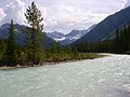
Sullivan mine
Sullivan Mine was an underground conventional–mechanized mine located in Kimberley, British Columbia, Canada; it has a complex, diatreme-hosted orebody, made up primarily of zinc sulfide, lead sulfide, and iron sulfides....
near Kimberley, British Columbia
Kimberley, British Columbia
Kimberley is a small city in southeast British Columbia, Canada along Highway 95A between the Purcell and Rocky Mountains. Kimberley was named in 1896 after the Kimberley mine in South Africa. From 1917 to 2001, it was the home to the world's largest lead-zinc mine, the Sullivan Mine...
, which is the largest in the Kootenay watershed. Agriculture
Agriculture
Agriculture is the cultivation of animals, plants, fungi and other life forms for food, fiber, and other products used to sustain life. Agriculture was the key implement in the rise of sedentary human civilization, whereby farming of domesticated species created food surpluses that nurtured the...
, however, is a much less important industry, and many of the fertile riverside lands have been flooded by the construction of dams (most notably Libby Dam in Montana, which backs water into Canada). Only about two percent of the entire Kootenay basin (1005 square kilometres (388 sq mi) is used for agriculture, and much of that is for pasture and foraging. Crops such as oats, barley and wheat account for 62 percent of the agricultural output of the region, much of which is used locally or exported by rail. The primary agricultural region is the Kootenai Valley of northern Idaho just south of Kootenay Lake.
The West Kootenay, however, is transitioning from a coal-mining to a tourism-based economy, and the rest of the Kootenay region is also starting to do so. The economy of southeastern British Columbia is becoming increasingly reliant on tourism, and several Canadian national and state parks have already been established, and several national forests in the U.S.
River modifications
Dams, power plants and diversions of the Kootenay River, of which there are many, have been built for a variety of reasons throughout the 19th and 20th centuries. The seven dams on the Kootenay serve many purposes, ranging from generation of local electricity to regulation of Columbia River flow between Canada and the United States. None provide for navigation or fish passage. In former times, the Kootenay would rise each spring and early summers with "enormous freshets that every summer flood the Kootenay River valley", but because of water regulation nowadays, such extreme variation in flow are no longer common on the lower river below Libby Dam.The Falls
As early as 1898, without building a dam, the Lower Bonnington Power Plant was generating hydroelectricityHydroelectricity
Hydroelectricity is the term referring to electricity generated by hydropower; the production of electrical power through the use of the gravitational force of falling or flowing water. It is the most widely used form of renewable energy...
from Bonnington Falls in the Kootenay River near the confluence of the Slocan River
Slocan River
The Slocan River is a long tributary of the Kootenay River in the Canadian province of British Columbia. It is part of the Columbia River basin, as the Kootenay River is a tributary of the Columbia River...
in order to supply water to mines in Rossland, British Columbia
Rossland, British Columbia
Rossland is a city in the West Kootenay region of British Columbia.Tucked high in the Monashee Mountains, Rossland is at an elevation of 1023 metres . Population today is approximately 3500; a number that fluctuates from season to season. The population is at its peak during the winter...
.
For Upper Bonnington, the first dam built on the river, the original goal was to improve navigation between Kootenay Lake and the Kootenay's mouth on the Columbia by drowning the dangerous Bonnigton Falls rapids that also blocked fish migration, and hopefully introducing fish to the upper river by constructing a fish ladder. None of these amenties for steamboats or salmon were ever constructed—in fact, the dam ended up being built above the falls instead of below them—and Upper Bonnington Dam, when completed in 1906, only generated hydroelectric power, and has served that purpose ever since.
Commercial demand led to two more dams at the falls, these were South Slocan Dam in 1928, and Corra Linn Dam
Corra Linn Dam
Corra Linn Dam is a concrete hydroelectric dam on the Kootenay River in the Canadian province of British Columbia. It is located where the West Arm Kootenay Lake flows into the Kootenay River. The dam's powerplant has a generating capacity of 49 MW. The dam was formerly owned by West Kootenay Power...
, at the rapids above Bonnington in 1932.
Three of the dams are of the run-of-the-river
Run-of-the-river hydroelectricity
Run-of-the-river hydroelectricity is a type of hydroelectric generation whereby a considerably smaller water storage called pondage or none is used to supply a power station. Run-of-the-river power plants are classified as with or without pondage...
type, the 4.5 km length of the falls is now impounded in small lakes. All except Corra Linn, which was built to raise and regulate the level of Kootenay Lake. The Kootenay Canal
Kootenay Canal
The Kootenay Canal is 19km downstream of Nelson, British Columbia, Canada. Where the Kootenay River flows out of the reservoir formed by the Corra Linn Dam on Kootenay Lake., a canal diverts water to BC Hydro's Kootenay Canal Generating Station...
Generating Station, completed in 1976 by BC Hydro
BC Hydro
The BC Hydro and Power Authority is a Canadian electric utility in the province of British Columbia generally known simply as BC Hydro. It is the main electric distributor, serving 1.8 million customers in most areas, with the exception of the Kootenay region, where FortisBC, a subsidiary of Fortis...
, has its inlet at Kootenay Lake next to Corra Linn. The canal travels several kilometers, parallel to and above the river to utilize the roughly 84 metres (275.6 ft) high water drop in elevation between Kootenay Lake and South Slocan, bypassing the old dams. The canal is used to generate hydroelectricity
Hydroelectricity
Hydroelectricity is the term referring to electricity generated by hydropower; the production of electrical power through the use of the gravitational force of falling or flowing water. It is the most widely used form of renewable energy...
, as are the four dams.
The Lower River
After the falls and the junction with the Slocan RiverSlocan River
The Slocan River is a long tributary of the Kootenay River in the Canadian province of British Columbia. It is part of the Columbia River basin, as the Kootenay River is a tributary of the Columbia River...
the last 18 km of the river is a gradual slope to the merger with the Columbia. In 1944 the last privately owned development Brilliant Dam
Brilliant Dam
Brilliant Dam is a hydroelectric dam on the Kootenay River near Castlegar, British Columbia, Canada. It was built during the Second World War, mostly by Doukhobour men exempt from military service, and its twin turbines first came into operation in June, 1944....
was built, just 2.5 km before the Kootenay river flows into the Columbia River
Columbia River
The Columbia River is the largest river in the Pacific Northwest region of North America. The river rises in the Rocky Mountains of British Columbia, Canada, flows northwest and then south into the U.S. state of Washington, then turns west to form most of the border between Washington and the state...
at Castlegar
Castlegar, British Columbia
Castlegar is the second largest city in the West Kootenay region of British Columbia, Canada. It is located within the Selkirk Mountains at the confluence of the Kootenay and Columbia Rivers. It is a regional trade and transportation centre, with a local economy fueled by forestry, mining and tourism...
.
Columbia River Treaty

Columbia Basin
The Columbia Basin, the drainage basin of the Columbia River, occupies a large area–about —of the Pacific Northwest region of North America. In common usage, the term often refers to a smaller area, generally the portion of the drainage basin that lies within eastern Washington.Usage of the term...
is noted for its spring floods, major flood years were 1876, 1894, 1948 and 1964. As recently as the mid 1960s, the upper Columbia and Kootenay rivers in British Columbia were still free-flowing and unaffected by dams and reservoirs, resulting in the 1948 Vanport Oregon flood. The uncontrolled discharge past the Canada-U.S. border created problems for electricity generation in the US, and Canada also wanted to utilize the Columbia river for the production of hydroelectric power. Negotiated in 1961 between the governments of the two countries, the Columbia River Treaty
Columbia River Treaty
The Columbia River Treaty is an agreement between Canada and the United States of America on the development and operation of dams in the upper Columbia River basin for power and flood control benefits in both countries. For more information about the Columbia River Treaty, visit Columbia Basin...
attempted to ratify these problems. Construction of the first three of the four dams authorized by the treaty—Mica
Mica Dam
The Mica Dam is a hydroelectric dam spanning the Columbia River 135 kilometres north of Revelstoke, British Columbia, Canada. Completed in 1973 under the terms of the 1964 Columbia River Treaty, the Mica powerhouse has a generating capacity of . The dam is operated by BC Hydro...
, Keenleyside
Keenleyside Dam
Hugh Keenleyside Dam is a hydroelectric dam spanning the Columbia River, 12 km upstream of the city of Castlegar, British Columbia, Canada....
and Duncan
Duncan Dam
Duncan Dam is a dam spanning the Duncan River in the Canadian province of British Columbia.Duncan Dam was the first dam built to satisfy the Columbia River Treaty, initiated after the 1948 Vanport Oregon flood. Construction began in 1965 and was completed in 1967. It is an earthfill dam with no...
—was implemented in 1964. Of the four dams, the first two are on the Columbia, the third is on the Duncan River
Duncan River
The Duncan River is a long river in the Canadian province of British Columbia. Its drainage basin is in area. It is part of the Columbia River basin, being tributary via Kootenay Lake to the Kootenay River, which is a tributary of the Columbia River...
, a tributary of the Kootenay, and the fourth Libby
Libby Dam
Libby Dam is a dam on the Kootenai River in the U.S. state of Montana.Dedicated on August 24, 1975, Libby Dam spans the Kootenai River upstream from the town of Libby, Montana. Libby Dam is tall and long. Lake Koocanusa is the name of the reservoir behind the dam; it extends upriver from...
, on the Kootenay River proper. However, operation of the dams has led to environmental problems in both rivers because they have caused unnatural flow fluctuations, blocked fish migration, flooded fertile agricultural land, and forced over 2,000 people to relocate.
Solely built for the purpose of regulating water flow into Kootenay Lake, Duncan Dam, the first dam built for the treaty, was raised in 1967 and increased the 25 km long size of Duncan Lake
Duncan Lake (British Columbia)
Duncan Lake is a man-made reservoir lake in the Kootenay region of British Columbia, Canada, formed by Duncan Dam and about 45 km in length. It is fed by the Duncan River, which forms part of the boundary between the Selkirk Mountains to the west and the Purcell Mountains to the east...
to a reservoir 45 kilometres (28 mi) long. Because of its purpose, it has no power generation facilities. Libby Dam, the fourth and last dam built under the treaty, was completed in 1975 by the U.S. Army Corps of Engineers. It is the first of the dams that the Kootenay encounters durings its journey and provides further regulation of the water that flows into Kootenay Lake. The other two dams built for the treaty, Keenleyside and Mica, are both on the Columbia River. Kootenay basin reservoirs provide nearly 7000000 acre.ft of storage which constitutes almost half of the 15500000 acre.ft stored in Columbia River Treaty reservoirs.
Diversion proposal
In the 1970s, it was proposed that the Kootenay River be diverted into the Columbia River (the two rivers are separated by a distance of no more than 2 kilometres (1.2 mi) in the Rocky Mountain Trench in southeastern British Columbia). This would allow for the generation of increased hydroelectric power on the Columbia. It would also make easier the reclamation of the Kootenay Flats, an area south of Kootenay Lake, for agricultural purposes—spring freshetFreshet
A freshet can refer to one of two things:* A flood resulting from heavy rain or a spring thaw. Whereas heavy rain often causes a flash flood, a spring thaw event is generally a more incremental process, depending upon local climate and topography...
s once raised the level of the lake by up to 8 metres (26.2 ft), inundating the lowlands around it. There were also never-implemented plans to divert part of the Kootenay enlarged Columbia River through a tunnel to the headwaters of the Thompson River
Thompson River
The Thompson River is the largest tributary of the Fraser River, flowing through the south-central portion of British Columbia, Canada. The Thompson River has two main branches called the South Thompson and the North Thompson...
in the northwest, and thence to the Fraser River
Fraser River
The Fraser River is the longest river within British Columbia, Canada, rising at Fraser Pass near Mount Robson in the Rocky Mountains and flowing for , into the Strait of Georgia at the city of Vancouver. It is the tenth longest river in Canada...
valley of southwestern British Columbia.
The proposal was strongly opposed by both environmentalists as well as local residents. The economy of southeastern British Columbia is strongly dependent on tourism, with the Columbia River, including Columbia Lake and Windermere Lake
Windermere Lake (British Columbia)
Lake Windermere is a very large widening in the Columbia River. The village of Windermere is located on the east side of the lake, and the larger town of Invermere is located on the lake's northwestern corner...
, being very popular for summer swimming and boating activities. Diversion of the glacier-fed Kootenay River would have resulted in the Columbia River becoming much deeper and colder, flooding riverside communities and damaging tourism. At the opposite end of the scale, it would dry the bed of the Kootenay River downstream of Canal Flats, cutting off water supply to residents of the upper Kootenay Valley and invalidating the effectiveness of Libby Dam, whose construction was to begin in a few years. As a result, this proposed river diversion was never undertaken.
Recreation

- Bugaboo Provincial ParkBugaboo Provincial ParkBugaboo Provincial Park is a provincial park in British Columbia, Canada, located in the central Purcell Mountains.The park is known primarily for the Bugaboos, a formation of mountains that attracts climbers and type:mountaineers, and for the Conrad Kain hut, an alpine hut managed by the Alpine...
- Creston Valley Wildlife Management AreaCreston ValleyThe Creston Valley is a Canadian river delta wetland and Wildlife Management Area near Creston in south-central British Columbia, on the floodplain of the Kootenay River at the south end of Kootenay Lake. Predominantly marshland, it was classified as a wetland of international importance on...
- Gilnockie Provincial ParkGilnockie Provincial ParkGilnockie Provincial Park is a provincial park in British Columbia, Canada....
- Goat Range Provincial ParkGoat Range Provincial ParkGoat Range Provincial Park is a provincial park in British Columbia, Canada.The park was established to protect unique species such as the Gerrard Rainbow Trout and the distinct subspecies of "White Grizzly" for which the park was first named...
- Kianuko Provincial ParkKianuko Provincial Park-History:The park was established July 12, 1995. This is an area of Ktunaxa-kinbasket First Nation traditional use and has high spiritual values.-Conservation:The park aims to protect important habitat for caribou, moose and grizzly bear, and fish.-Recreation:...
- Kokanee Glacier Provincial ParkKokanee Glacier Provincial ParkKokanee Glacier Provincial Park is one of the oldest provincial parks in British Columbia, established in 1922. The park has an area of and is located in the Selkirk Mountains in the West Kootenays region of BC...
- Kootenay National ParkKootenay National ParkKootenay National Park is located in southeastern British Columbia Canada covering in the Canadian Rockies and forms part of a World Heritage Site. The park ranges in elevation from at the south-west park entrance to at Deltaform Mountain...
- Mount Assiniboine Provincial ParkMount Assiniboine Provincial ParkMount Assiniboine Provincial Park is a provincial park in British Columbia, Canada, located around Mount Assiniboine.-History:The park was established 1922...
- Purcell Wilderness Conservancy Provincial Park and Protected AreaPurcell Wilderness Conservancy Provincial Park and Protected AreaPurcell Wilderness Conservancy Provincial Park and Protected Area is a provincial park in British Columbia, Canada....
- St. Mary's Alpine Provincial ParkSt. Mary's Alpine Provincial ParkSt. Mary's Alpine Provincial Park is a provincial park in British Columbia, Canada. According to the Canadian Ministry of the Environment:St. Mary’s Alpine Park is a wilderness paradise for the experienced backcountry traveller. Numerous lakes and tarns are tucked against rugged granite cliffs and...
- Top of the World Provincial ParkTop of the World Provincial ParkTop of the World Provincial Park is a provincial park in British Columbia, Canada.-External links:*...
- Valhalla Provincial ParkValhalla Provincial ParkValhalla Provincial Park is a provincial park in British Columbia, Canada.It was established on March 3rd, 1983 in the mountains above the Western shores of Slocan Lake, in the west Kootenays. The park consists of most of the Valhalla Range of the Selkirk Mountains.It is 49,893 hectares in size...
- West Arm Provincial ParkWest Arm Provincial ParkWest Arm Provincial Park is a provincial park in British Columbia, Canada....
Popular Banff National Park
Banff National Park
Banff National Park is Canada's oldest national park, established in 1885 in the Rocky Mountains. The park, located 110–180 kilometres west of Calgary in the province of Alberta, encompasses of mountainous terrain, with numerous glaciers and ice fields, dense coniferous forest, and alpine...
lies just across the BC-Alberta border, Yoho National Park
Yoho National Park
Yoho National Park is located in the Canadian Rocky Mountains along the western slope of the Continental Divide in southeastern British Columbia. Yoho NP is bordered by Kootenay National Park on the southern side and Banff National Park on the eastern side...
sits to the north, and Glacier National Park
Glacier National Park (Canada)
Glacier National Park is one of seven national parks in British Columbia, and is part of a system of 43 parks and park reserves across Canada. It protects a portion of the Columbia Mountains. It also contains the Rogers Pass National Historic Site, designated for its importance in the construction...
in the northeast. The U.S. portion of the watershed includes Kootenai National Forest
Kootenai National Forest
Kootenai National Forest is located in the far northwestern section of Montana and the northeasternmost lands in the Idaho panhandle, United States along the Canadian border. Of the 2.2 million acres administered by the forest, less than 3 percent is located in the state of Idaho. Forest...
and Kaniksu National Forest
Kaniksu National Forest
The Kaniksu National Forest is a U.S. National Forest located in northeastern Washington, the Idaho panhandle, and northwestern Montana. The Idaho portion is one of three forests that are aggregated into the Idaho Panhandle National Forest, along with the Coeur d'Alene National Forest and St. Joe...
(part of the Idaho Panhandle National Forest
Idaho Panhandle National Forest
Idaho Panhandle National Forest is a national forest located in the U.S. state of Idaho. Approximately 22.4% of the forest extends into the states of Montana and Washington . The forest was combined in 2000 from three previous separate National Forests which continue to manage themselves somewhat...
s, which stretch southwards into the state).
In Kootenay National Park alone, there are over 200 kilometres (124.3 mi) of hiking trails, ranging from short day hikes to long backpacking
Backpacking (wilderness)
Backpacking combines the activities of hiking and camping for an overnight stay in backcountry wilderness...
trips. Cross-country skiing
Cross-country skiing
Cross-country skiing is a winter sport in which participants propel themselves across snow-covered terrain using skis and poles...
and snowshoeing are popular on the park's trails in the winter. Mount Assiniboine Provincial Park, which sits right next to Kootenay in the Rocky Mountains, also has an extensive trail system affording extensive views of the surrounding ranges. Kikomun Creek Provincial Park
Kikomun Creek Provincial Park
Kikomun Creek Provincial Park is a provincial park in British Columbia, Canada.Kikomun Creek Provincial Park has a campground with five lakes, an abundance of the endangered painted turtles, many mountain bike trails throughout, two beautiful sandy beaches among its attractions.-Geography:Kikomun...
, on the northeast shore of Lake Koocanusa, includes campgrounds and access to boat launches on the east shore of the lake. The Kootenai River Trail along the Montana section of the river,
about 10 kilometres (6.2 mi) long, follows the river from Libby
Libby, Montana
Libby is a city in and the county seat of Lincoln County, Montana, United States. The population was 2,626 at the 2000 census.-Geography:Libby is located at , along U.S. Route 2....
to Kootenai Falls and the well known Swinging Bridge across the Kootenai. Skattebo Reach Trail, on the lower river, is about 14 kilometres (8.7 mi) long, running from Brilliant
Brilliant, British Columbia
Brilliant is a settlement in British Columbia....
to Glade. Further downstream, five separate sites around Kootenay Lake form the Kootenay Lake Provincial Park
Kootenay Lake Provincial Park
Kootenay Lake Provincial Park is a provincial park in British Columbia, Canada. It encompasses five widely dispersed parks around Kootenay Lake: Kootenay Lake Provincial Park , Kootenay Lake Provincial Park , Kootenay Lake Provincial Park , Kootenay Lake Provincial Park , and Kootenay Lake...
. West Arm Provincial Park is located on the impounded stretch of the Kootenay River just west of Kootenay Lake, and to the northeast of Nelson. Smaller Kokanee Creek Provincial Park
Kokanee Creek Provincial Park
Kokanee Creek Provincial Park is a provincial park in British Columbia, Canada. The park is situated on the shores of Kootenay Lake and is bisected by Highway 3A 19 km east of Nelson, British Columbia. Established as a BC Provincial Park in 1955 it encompasses 260 hectares of sandy beaches,...
, one of the more popular recreation areas in the West Kootenay, sits across the river from West Arm.
Fishing is generally good on the middle reaches of the Kootenay River and in Kootenay Lake. Westslope cutthroat trout
Westslope cutthroat trout
The westslope cutthroat trout , also known as the blackspotted cutthroat, is a subspecies of the cutthroat trout and is a freshwater fish in the salmon family of order Salmoniformes. The cutthroat is the Montana state fish...
, bull trout
Bull trout
The bull trout, Salvelinus confluentus, is a char of the family Salmonidae native to northwestern North America. Historically, S. confluentus has been known as the "Dolly Varden" , but was re-classified as a separate species in 1980. Bull trout are listed as a threatened species under the U.S....
, kokanee salmon (the landlocked Pacific salmon), rainbow trout
Rainbow trout
The rainbow trout is a species of salmonid native to tributaries of the Pacific Ocean in Asia and North America. The steelhead is a sea run rainbow trout usually returning to freshwater to spawn after 2 to 3 years at sea. In other words, rainbow trout and steelhead trout are the same species....
and white sturgeon
White sturgeon
The white sturgeon , also known as the Pacific sturgeon, Oregon sturgeon, Columbia sturgeon, Sacramento sturgeon, and California white sturgeon, is a sturgeon which lives along the west coast of North America from the Aleutian Islands to Central...
are among the many species found in the river. Kokanee and rainbows are commonly found in Lake Koocanusa. Kootenai Falls, which drops some 90 metres (295.3 ft) within a run of a few hundred meters, forms a natural boundary between fishes of the upper and lower river, but Libby Dam, several kilometres upstream, is an even more formidable barrier. Fish in the Kootenay have traditionally been abundant but the construction of the dam may have led to declines in the population of sturgeon, among other fishes, because of changes in water flow. The best season for fishing is from June to November. One may fish from banks, sandbars and islands, or from boats. Because of the size and strength of the river, fishing from drift boats is easier than from the shore. Also, because the Kootenay's primary sources are glaciers, fishing conditions are quite different than most rivers in Montana and Idaho, which are fed by snowmelt.
In the United States, the Kootenay, with its “exceptional” trout fishing, is considered a Blue Ribbon fishery.
Steep and strewn with rapids, the Kootenay, despite being unsuitable for commercial transportation of agricultural and mineral products, is considered a outstanding whitewater river. Whitewater rafting is popular on the Kootenay in two stretches: in Jennings Canyon between the Libby Dam in Montana and Bonners Ferry in Idaho, and in the upper reaches of the river in Kootenay National Park in British Columbia.
Rafting the middle Kootenay between Libby Dam and Bonners Ferry is best at flows of 8000 cuft/s. The run, about 60 kilometres (37.3 mi) from east to west, includes Class IV+ rapids and includes Kootenai Falls, which rarely has been run safely, in the middle of its course. In Montana, the river is rated a Class I water under the Montana Stream Access Law
Montana Stream Access Law
The Montana Stream Access Law says that anglers, floaters and other recreationists in Montana have full use of most natural waterways between the high water marks for fishing and floating, along with swimming and other river or stream-related activities...
for recreational purposes from Libby Dam to the Montana-Idaho border. Class I represents bodies of water that are navigable and suitable for recreation.
Rafting is also popular in some of the Canadian stretches of the river, especially those near the headwaters that have the steepest gradient and the most challenging rapids. Several Canadian outfitters provide trips on the river near Kootenay National Park ranging from a few hours to several days. Canoeing in the numerous sloughs, side-channels and distributaries of the Kootenay that thread through the wetlands of the Kootenay Flats has the additional benefit of watching birds and wildlife in the Creston Valley Wildlife Management Unit and other surrounding marshes. Larger craft such as houseboat
Houseboat
A houseboat is a boat that has been designed or modified to be used primarily as a human dwelling. Some houseboats are not motorized, because they are usually moored, kept stationary at a fixed point and often tethered to land to provide utilities...
s are able to travel on Kootenay and Koocanusa Lakes. Rafting and kayaking is also an activity on the swift-flowing Slocan River
Slocan River
The Slocan River is a long tributary of the Kootenay River in the Canadian province of British Columbia. It is part of the Columbia River basin, as the Kootenay River is a tributary of the Columbia River...
, the lowermost major tributary of the Kootenay, and in parts of other major Kootenay tributaries as well.
Crossings
Crossings of the Kootenay River are listed from upstream to downstream. The name of the road/track, the coordinates, and the location are given.| Road or railway | Location | Coordinates | Image |
|---|---|---|---|
| BC Highway 93 | Kootenay Crossing, BC | 50.8869°N 116.0455°W | |
| BC Highway 93/95 | Canal Flats, BC | 50.1479°N 115.8009°W | |
| BC Highway 93/95 | Skookumchuck, BC | 49.9108°N 115.7372°W | |
| BC Highway 93/95 | Near Wasa Lake Provincial Park Wasa Lake Provincial Park Wasa Lake Provincial Park is a provincial park in British Columbia, Canada.... , BC |
49.8094°N 115.7671°W | |
| BC Highway 93/95 | Fort Steele, BC | 49.6125°N 115.6345°W | |
| BC Highway 3/95 | Near Wardner, BC | 49.4333°N 115.4224°W | |
| Kikomun-Newgate Road | Near Kikomun Creek Provincial Park, BC | 49.2602°N 115.2727°W | |
| Libby Dam Libby Dam Libby Dam is a dam on the Kootenai River in the U.S. state of Montana.Dedicated on August 24, 1975, Libby Dam spans the Kootenai River upstream from the town of Libby, Montana. Libby Dam is tall and long. Lake Koocanusa is the name of the reservoir behind the dam; it extends upriver from... |
Near Jennings, MT | 48.4096°N 115.3146°W | _1986.jpg) |
| Montana Highway 37 | Near Jennings, MT | 48.3658°N 115.3252°W | |
| Montana Highway 37 | Libby, MT | 48.3966°N 115.5477°W | |
| U.S. Route 2 U.S. Route 2 U.S. Route 2 is an east–west U.S. Highway spanning across the northern continental United States. US 2 consists of two segments connected by various roadways in southern Canada... |
Troy, MT | 48.4951°N 115.9179°W | |
| Leona Road | MT-ID border | 48.6171°N 116.0482°W | |
| U.S. Highway 2/95 | Bonners Ferry, ID | 48.6998°N 116.3132°W | |
| Crowsnest Highway Crowsnest Highway The Crowsnest Highway, also known as the Interprovincial or, in British Columbia, the Southern Trans-Provincial, is an east-west highway, in length, through the southern parts of British Columbia and Alberta, providing the shortest highway connection between British Columbia's Lower Mainland and... |
Near Creston, BC | 49.1173°N 116.5805°W | |
| Nelson Bridge (BC Highway 3A) | Nelson, BC | 49.5103°N 117.2821°W | |
| Corra Linn Dam Corra Linn Dam Corra Linn Dam is a concrete hydroelectric dam on the Kootenay River in the Canadian province of British Columbia. It is located where the West Arm Kootenay Lake flows into the Kootenay River. The dam's powerplant has a generating capacity of 49 MW. The dam was formerly owned by West Kootenay Power... |
Corra Linn, BC | 49.4680°N 117.4675°W | |
| Upper Bonnington Falls Dam | Bonnington Falls, BC | 49.4588°N 117.4858°W | |
| Lower Bonnington Falls Dam | Bonnington Falls, BC | 49.4609°N 117.4998°W | |
| Blewett Road | Near South Slocan, BC | 49.4590°N 117.5092°W | |
| South Slocan Dam | Near South Slocan, BC | 49.4563°N 117.5181°W | |
| Brilliant Dam Brilliant Dam Brilliant Dam is a hydroelectric dam on the Kootenay River near Castlegar, British Columbia, Canada. It was built during the Second World War, mostly by Doukhobour men exempt from military service, and its twin turbines first came into operation in June, 1944.... |
Near Brilliant, BC | 49.3244°N 117.6195°W | 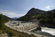 |
| BC Highway 3A (Brilliant Bridge) | Near Brilliant, BC and river’s mouth | 49.3168°N 117.6311°W | |
| References: ACME Mapper | |||
See also
- List of longest rivers of Canada
- List of rivers of British Columbia
- List of rivers of Idaho
- List of rivers of Montana
- Montana Stream Access LawMontana Stream Access LawThe Montana Stream Access Law says that anglers, floaters and other recreationists in Montana have full use of most natural waterways between the high water marks for fishing and floating, along with swimming and other river or stream-related activities...
- List of tributaries of the Columbia River
- List of dams in the Columbia River watershed
- Confederated Salish and Kootenai Tribes of the Flathead NationConfederated Salish and Kootenai Tribes of the Flathead NationThe Confederated Salish and Kootenai Tribes of the Flathead Reservation are the Bitterroot Salish, Kootenai and Pend d'Oreilles Tribes. The Flatheads lived between the Cascade Mountains and Rocky Mountains. The Salish initially lived entirely east of the Continental Divide but established their...
- Dewdney Trail