
North Yamhill River
Encyclopedia
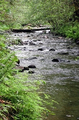
The North Yamhill River is a 31 miles (49.9 km) tributary of the Yamhill River
in the U.S. state
of Oregon
. It drains an area of the Northern Oregon Coast Range
, as well as part of the Willamette Valley
west of the Willamette River
.
Rising in a remote area in the mountains of northwestern Yamhill County
, the river flows generally east, then southeast, then south past the city of Yamhill
. It joins the South Yamhill River
about 2 miles (3.2 km) east of McMinnville
to form the Yamhill River.
and falls 2392 feet (729.1 m) between source and mouth to an elevation of 75 feet (22.9 m). It rises northeast of Trask Mountain, a 3412 feet (1,040 m) peak at 45°22′17"N 123°27′23"W, in the Northern Oregon Coast Range. The source, at about river mile
(RM) 31 or river kilometer (RK) 50, lies near the border between Tillamook County
and Yamhill County northwest of the city of Yamhill.
Flowing south and then southeast for its first 1 miles (1.6 km), the river receives Perkins Creek from the right. Heading east, it receives Maroney Creek from the right before reaching the Flying M Ranch and Flying M Airport
at about RM 26 (RK 42), where it receives Hanna Creek from the left and Petch Creek from the right. Continuing east, the stream receives Fairchild Creek from the left, Haskins Creek from the right, and Cedar Creek from the left before reaching Pike at RM 20 (RK 32). Shortly thereafter, the river turns southeast, and Turner Creek enters from the left.
About 1 miles (1.6 km) below Pike, the valley widens, and the river begins to meander and to turn more sharply south, receiving Hutchcroft Creek from the right and Salt Creek from the left near RM 16 (RK 26). Turning southeast again, the river flows by the city of Yamhill, which lies to its left, and receives Rowland Creek and Yamhill Creek, both from the left. From Yamhill to the mouth
, the North Yamhill River flows generally south and roughly parallel to Oregon Route 47, which lies to its left. Soon the river reaches Alecs Butte, a 384 feet (117 m) summit at 45°19′13"N 123°11′04"W, on the left at about RM 13 (RK 21).
About 1 miles (1.6 km) later, the stream enters Carlton Lake Wildlife Refuge and flows through it, reaching the city of Carlton
, on the left at RM 10 (RK 16). Slightly downstream of RM 4.0 (RK 6.4), Panther Creek enters from the right. The river passes under Oregon Route 99W at about RM 1.0 (RK 1.6) before joining the South Yamhill River to form the Yamhill River, an 11 miles (17.7 km) tributary of the Willamette River.
Yamhill River
The Yamhill River is an tributary of the Willamette River, in the U.S. state of Oregon. Formed by the confluence of the South Yamhill River and the North Yamhill River about east of McMinnville, it drains part of the Northern Oregon Coast Range...
in the U.S. state
U.S. state
A U.S. state is any one of the 50 federated states of the United States of America that share sovereignty with the federal government. Because of this shared sovereignty, an American is a citizen both of the federal entity and of his or her state of domicile. Four states use the official title of...
of Oregon
Oregon
Oregon is a state in the Pacific Northwest region of the United States. It is located on the Pacific coast, with Washington to the north, California to the south, Nevada on the southeast and Idaho to the east. The Columbia and Snake rivers delineate much of Oregon's northern and eastern...
. It drains an area of the Northern Oregon Coast Range
Northern Oregon Coast Range
The Northern Oregon Coast Range is the northern section of the Oregon Coast Range, in the Pacific Coast Ranges physiographic region, located in the northwest portion of the state of Oregon, United States. This section of the mountain range, part of the Pacific Coast Ranges, contains peaks as high...
, as well as part of the Willamette Valley
Willamette Valley
The Willamette Valley is the most populated region in the state of Oregon of the United States. Located in the state's northwest, the region is surrounded by tall mountain ranges to the east, west and south and the valley's floor is broad, flat and fertile because of Ice Age conditions...
west of the Willamette River
Willamette River
The Willamette River is a major tributary of the Columbia River, accounting for 12 to 15 percent of the Columbia's flow. The Willamette's main stem is long, lying entirely in northwestern Oregon in the United States...
.
Rising in a remote area in the mountains of northwestern Yamhill County
Yamhill County, Oregon
-National protected areas:*Siuslaw National Forest *Tualatin River National Wildlife Refuge -Demographics:As of the census of 2000, there were 84,992 people, 28,732 households, and 21,376 families residing in the county. The population density was 119 people per square mile . There were 30,270...
, the river flows generally east, then southeast, then south past the city of Yamhill
Yamhill, Oregon
Yamhill is a city in Yamhill County, Oregon, United States. Located in the northern part of the county, it is situated at the intersection of Oregon Route 47 and Oregon Route 240. The population was 794 at the 2000 census. The 2008 estimate is 855 residents...
. It joins the South Yamhill River
South Yamhill River
The South Yamhill River is a tributary of the Yamhill River, approximately long, in northwest Oregon in the United States. It drains an area of the Northern Oregon Coast Range, as well as part of the Willamette Valley west of the Willamette River.-Course:...
about 2 miles (3.2 km) east of McMinnville
McMinnville, Oregon
McMinnville is the county seat and largest city of Yamhill County, Oregon, United States. According to Oregon Geographic Names, it was named by its founder, William T. Newby , an early immigrant on the Oregon Trail, for his hometown of McMinnville, Tennessee...
to form the Yamhill River.
Course
The river begins at an elevation of 2467 feet (751.9 m) above sea levelSea level
Mean sea level is a measure of the average height of the ocean's surface ; used as a standard in reckoning land elevation...
and falls 2392 feet (729.1 m) between source and mouth to an elevation of 75 feet (22.9 m). It rises northeast of Trask Mountain, a 3412 feet (1,040 m) peak at 45°22′17"N 123°27′23"W, in the Northern Oregon Coast Range. The source, at about river mile
River mile
In the United States, a River mile is a measure of distance in miles along a river from its mouth. River mile numbers begin at zero and increase further upstream. The corresponding metric unit using kilometers is the River kilometer...
(RM) 31 or river kilometer (RK) 50, lies near the border between Tillamook County
Tillamook County, Oregon
Tillamook County is a county located in the U.S. state of Oregon. The county is named for the Tillamook, a Native American tribe who were living in the area in the early 19th century at the time of European American settlement. In 2010, the county's population was 25,250...
and Yamhill County northwest of the city of Yamhill.
Flowing south and then southeast for its first 1 miles (1.6 km), the river receives Perkins Creek from the right. Heading east, it receives Maroney Creek from the right before reaching the Flying M Ranch and Flying M Airport
Flying M Airport
Flying M Airport is a private airport located 7 miles west of Yamhill in Yamhill County, Oregon, USA....
at about RM 26 (RK 42), where it receives Hanna Creek from the left and Petch Creek from the right. Continuing east, the stream receives Fairchild Creek from the left, Haskins Creek from the right, and Cedar Creek from the left before reaching Pike at RM 20 (RK 32). Shortly thereafter, the river turns southeast, and Turner Creek enters from the left.
About 1 miles (1.6 km) below Pike, the valley widens, and the river begins to meander and to turn more sharply south, receiving Hutchcroft Creek from the right and Salt Creek from the left near RM 16 (RK 26). Turning southeast again, the river flows by the city of Yamhill, which lies to its left, and receives Rowland Creek and Yamhill Creek, both from the left. From Yamhill to the mouth
River delta
A delta is a landform that is formed at the mouth of a river where that river flows into an ocean, sea, estuary, lake, reservoir, flat arid area, or another river. Deltas are formed from the deposition of the sediment carried by the river as the flow leaves the mouth of the river...
, the North Yamhill River flows generally south and roughly parallel to Oregon Route 47, which lies to its left. Soon the river reaches Alecs Butte, a 384 feet (117 m) summit at 45°19′13"N 123°11′04"W, on the left at about RM 13 (RK 21).
About 1 miles (1.6 km) later, the stream enters Carlton Lake Wildlife Refuge and flows through it, reaching the city of Carlton
Carlton, Oregon
Carlton is a city in Yamhill County, Oregon, United States. According to the 2000 United States Census, the municipality population was 1,514. The 2007 estimate is 1,755 residents.-History:...
, on the left at RM 10 (RK 16). Slightly downstream of RM 4.0 (RK 6.4), Panther Creek enters from the right. The river passes under Oregon Route 99W at about RM 1.0 (RK 1.6) before joining the South Yamhill River to form the Yamhill River, an 11 miles (17.7 km) tributary of the Willamette River.