
Priest Rapids Dam
Encyclopedia
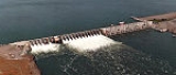
Priest Rapids Dam is a hydroelectric, concrete gravity dam
; located on the Columbia River
, between the Yakima Firing Range and the Hanford Nuclear Reservation
, and bridges Yakima County
and Grant County, in the U.S. state
of Washington. The dam is 24 miles south of the town of Vantage
, and 47 miles northeast of the town of Richland
. It is located at mile marker 397.1 from the mouth of the Columbia. It is owned by the Grant County Public Utility District
. Priest Rapids
, for which the dam was named, are now submerged beneath the dam's reservoir.
Priest Rapids Dam is part of the Columbia River Basin system of dams.
, and Portland, Oregon
, the federal government established the Priest Rapids Project under the Flood Control Act of 1950
(Public Law 81-516; May 17, 1950). The U.S. Army Corps of Engineers decided the project would not be a top priority, so the Grant PUD began looking at taking over the project from the USACE in 1952. With the passage of Public Law 83-544 in 1954, Congress gave Grant PUD the right to proceed. Revenue bonds were issued for construction to began in July 1956, first generation occurred in 1959, and the dam was completed in 1961. Its reservoir is named Priest Rapids Lake, and extends 18 miles upstream to spillway of Wanapum Dam
. Downriver from Priest Rapids Dam is Hanford Reach
, the only free-flowing, non-tidal stretch of the Columbia River in the United States.
The initial license expired in 2005, after which the Grant County PUD operated the dam on yearly license extensions while negotiations for license extension proceeded. The Federal Energy Regulatory Commission
approved a license extension of 44 years for both this dam and the upstream Wanapum dam
on April 17, 2008. The license extension was conditioned upon programs to:
Dam
A dam is a barrier that impounds water or underground streams. Dams generally serve the primary purpose of retaining water, while other structures such as floodgates or levees are used to manage or prevent water flow into specific land regions. Hydropower and pumped-storage hydroelectricity are...
; located on the Columbia River
Columbia River
The Columbia River is the largest river in the Pacific Northwest region of North America. The river rises in the Rocky Mountains of British Columbia, Canada, flows northwest and then south into the U.S. state of Washington, then turns west to form most of the border between Washington and the state...
, between the Yakima Firing Range and the Hanford Nuclear Reservation
Hanford Site
The Hanford Site is a mostly decommissioned nuclear production complex on the Columbia River in the U.S. state of Washington, operated by the United States federal government. The site has been known by many names, including Hanford Works, Hanford Engineer Works or HEW, Hanford Nuclear Reservation...
, and bridges Yakima County
Yakima County, Washington
Yakima County is the second largest county by area in the U.S. state of Washington. It is named after the Yakama tribe of Native Americans. In the 2010 census, its population was 243,231...
and Grant County, in the U.S. state
U.S. state
A U.S. state is any one of the 50 federated states of the United States of America that share sovereignty with the federal government. Because of this shared sovereignty, an American is a citizen both of the federal entity and of his or her state of domicile. Four states use the official title of...
of Washington. The dam is 24 miles south of the town of Vantage
Vantage, Washington
Vantage is a census-designated place in Kittitas County, Washington, United States. The population was 70 at the 2000 census.-History:The area around Vantage has been occupied by the Wanapum Native Americans since prehistory. A number of well-preserved rock-paintings have been found on the cliff...
, and 47 miles northeast of the town of Richland
Richland, Washington
Richland is a city in Benton County in the southeastern part of the U.S. state of Washington, at the confluence of the Yakima and the Columbia Rivers. As of the 2010 census, the city population was 48,058. April 1, 2011 estimates from the Washington State Office of Financial Management put the...
. It is located at mile marker 397.1 from the mouth of the Columbia. It is owned by the Grant County Public Utility District
Grant County Public Utility District
Public Utility District No. 2 of Grant County, or Grant County PUD, is a public utility district in north central Washington state. It is owned by its customers and governed by a Board of Commissioners elected by the customer-owners. Though it is not regulated by another governmental unit, a PUD...
. Priest Rapids
Priest Rapids
Priest Rapids was a narrow, fast-flowing stretch of the Columbia River, located in the central region of the U.S. state of Washington. It was flooded by the construction of the Priest Rapids Dam in the 1950s....
, for which the dam was named, are now submerged beneath the dam's reservoir.
Priest Rapids Dam is part of the Columbia River Basin system of dams.
History
After the disaster of 1948 Vanport Flood on the lower Columbia River, around Vancouver, WashingtonVancouver, Washington
Vancouver is a city on the north bank of the Columbia River in the U.S. state of Washington. Incorporated in 1857, it is the fourth largest city in the state with a 2010 census population of 161,791 as of April 1, 2010...
, and Portland, Oregon
Portland, Oregon
Portland is a city located in the Pacific Northwest, near the confluence of the Willamette and Columbia rivers in the U.S. state of Oregon. As of the 2010 Census, it had a population of 583,776, making it the 29th most populous city in the United States...
, the federal government established the Priest Rapids Project under the Flood Control Act of 1950
Flood Control Act of 1950
The Flood Control Act of 1950 was a law passed by the United States Congress authorizing flood control projects in Montana, Wyoming, Utah, Nevada, Idaho, Oregon, and Washington....
(Public Law 81-516; May 17, 1950). The U.S. Army Corps of Engineers decided the project would not be a top priority, so the Grant PUD began looking at taking over the project from the USACE in 1952. With the passage of Public Law 83-544 in 1954, Congress gave Grant PUD the right to proceed. Revenue bonds were issued for construction to began in July 1956, first generation occurred in 1959, and the dam was completed in 1961. Its reservoir is named Priest Rapids Lake, and extends 18 miles upstream to spillway of Wanapum Dam
Wanapum Dam
Wanapum Dam is a hydroelectric project located on the Columbia River downstream from Vantage, Washington where Interstate 90 crosses the Columbia from Grant County into Kittitas County. It is owned by the Grant County Public Utility District. Its reservoir is named Lake Wanapum.The dam, and its...
. Downriver from Priest Rapids Dam is Hanford Reach
Hanford Reach
The Hanford Reach is a free-flowing section of the Columbia River, about long, in eastern Washington state, named after a large northward bend in the river's otherwise southbound course. It is the only section of the Columbia in the U.S...
, the only free-flowing, non-tidal stretch of the Columbia River in the United States.
The initial license expired in 2005, after which the Grant County PUD operated the dam on yearly license extensions while negotiations for license extension proceeded. The Federal Energy Regulatory Commission
Federal Energy Regulatory Commission
The Federal Energy Regulatory Commission is the United States federal agency with jurisdiction over interstate electricity sales, wholesale electric rates, hydroelectric licensing, natural gas pricing, and oil pipeline rates...
approved a license extension of 44 years for both this dam and the upstream Wanapum dam
Wanapum Dam
Wanapum Dam is a hydroelectric project located on the Columbia River downstream from Vantage, Washington where Interstate 90 crosses the Columbia from Grant County into Kittitas County. It is owned by the Grant County Public Utility District. Its reservoir is named Lake Wanapum.The dam, and its...
on April 17, 2008. The license extension was conditioned upon programs to:
- modernize the power generation capability of the dam
- monitor water quality
- improve wildlife habitat
- protect nearly 700 Wanapum TribeWanapumThe Wanapum tribe of Native Americans formerly lived along the Columbia River from above Priest Rapids down to the mouth of the Snake River in what is now the U.S. state of Washington. About 60 Wanapum still live near the present day site of Priest Rapids Dam...
archaeological sites in the vicinity - enhance recreation with new campsites, picnic areas and trails