

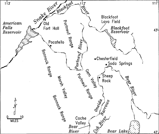
Blackfoot River (Idaho)
Encyclopedia
The Blackfoot River is a tributary
of the Snake River
in the U.S. state
of Idaho
. Formed by the confluence of Diamond Creek and Lanes Creek, it flows 136 miles (218.9 km) to its mouth at the Snake River. The river is part of the Columbia River Basin.
The Blackfoot River's drainage basin
is approximately 1097 square miles (2,841 km²) in area. Its mean annual discharge
, as measured at by USGS gage 13068501 (Combination Blackfoot River and Bypass Channel near Blackfoot, Idaho
), is 210 cuft/s, with a maximum daily recorded flow of 2130 cuft/s, and a minimum of zero flow.
The river is named for the Blackfoot Indians even though they never lived in the area. It was first mapped by the Lewis and Clark expedition.
in Caribou County
near Soda Springs, Idaho
. It flows northwest through the Blackfoot River Reservoir, which is used for irrigation and flood control, then west to join the Snake River in Bingham County.
The Blackfoot River's headwaters are very close to the headwaters of the Bear River and the Portneuf River
. All three begin in a few square miles of relatively flat land near Soda Springs, from which some headwater streams flow north to the Blackfoot River, others south to the Bear River, and others west to the Portneuf River.
which had their origin in the Blackfoot-Gem Valley lava field. The Blackfoot River flows from open marsh and grass lands near its source into the Blackfoot Narrows. The Blackfoot Narrows traverses a desert canyon of primarily sagebrush
and juniper
habitat: an excellent place to view birds of prey. Fishing for trout
is usually good.
Tributary
A tributary or affluent is a stream or river that flows into a main stem river or a lake. A tributary does not flow directly into a sea or ocean...
of the Snake River
Snake River
The Snake is a major river of the greater Pacific Northwest in the United States. At long, it is the largest tributary of the Columbia River, the largest North American river that empties into the Pacific Ocean...
in the U.S. state
U.S. state
A U.S. state is any one of the 50 federated states of the United States of America that share sovereignty with the federal government. Because of this shared sovereignty, an American is a citizen both of the federal entity and of his or her state of domicile. Four states use the official title of...
of Idaho
Idaho
Idaho is a state in the Rocky Mountain area of the United States. The state's largest city and capital is Boise. Residents are called "Idahoans". Idaho was admitted to the Union on July 3, 1890, as the 43rd state....
. Formed by the confluence of Diamond Creek and Lanes Creek, it flows 136 miles (218.9 km) to its mouth at the Snake River. The river is part of the Columbia River Basin.
The Blackfoot River's drainage basin
Drainage basin
A drainage basin is an extent or an area of land where surface water from rain and melting snow or ice converges to a single point, usually the exit of the basin, where the waters join another waterbody, such as a river, lake, reservoir, estuary, wetland, sea, or ocean...
is approximately 1097 square miles (2,841 km²) in area. Its mean annual discharge
Discharge (hydrology)
In hydrology, discharge is the volume rate of water flow, including any suspended solids , dissolved chemical species and/or biologic material , which is transported through a given cross-sectional area...
, as measured at by USGS gage 13068501 (Combination Blackfoot River and Bypass Channel near Blackfoot, Idaho
Blackfoot, Idaho
Blackfoot is a city in Bingham County, Idaho, United States. The population was 10,419 at the 2000 census. The city is the county seat of Bingham County. Blackfoot is self-designated the "Potato Capital of the World", because it claims to have the largest potato industry in the world...
), is 210 cuft/s, with a maximum daily recorded flow of 2130 cuft/s, and a minimum of zero flow.
The river is named for the Blackfoot Indians even though they never lived in the area. It was first mapped by the Lewis and Clark expedition.
Course
The Blackfoot River is formed by the joining of Diamond and Lanes creeks, in the Caribou-Targhee National ForestCaribou-Targhee National Forest
Caribou-Targhee National Forest is located in the states of Idaho and Wyoming, with a small section in Utah in the United States. The forest is broken into several separate sections and extends over . To the east the forest borders Yellowstone National Park, Grand Teton National Park and...
in Caribou County
Caribou County, Idaho
Caribou County is a county located in the U.S. state of Idaho. As of the 2010 Census the county had a population of 6,963. The county seat and largest city is Soda Springs, followed by Grace and Bancroft.- History :...
near Soda Springs, Idaho
Soda Springs, Idaho
Soda Springs is a city in Caribou County, Idaho, United States. The population was 3,381 at the 2000 census. The city is the county seat of Caribou County....
. It flows northwest through the Blackfoot River Reservoir, which is used for irrigation and flood control, then west to join the Snake River in Bingham County.
The Blackfoot River's headwaters are very close to the headwaters of the Bear River and the Portneuf River
Portneuf River (Idaho)
The Portneuf River is a tributary of the Snake River in southeastern Idaho in the United States. It drains a ranching and farming valley in the mountains southeast of the Snake River Plain...
. All three begin in a few square miles of relatively flat land near Soda Springs, from which some headwater streams flow north to the Blackfoot River, others south to the Bear River, and others west to the Portneuf River.
Watershed
The region the Blackfoot River flows through is covered in all its lowest portions with flows of basaltBasalt
Basalt is a common extrusive volcanic rock. It is usually grey to black and fine-grained due to rapid cooling of lava at the surface of a planet. It may be porphyritic containing larger crystals in a fine matrix, or vesicular, or frothy scoria. Unweathered basalt is black or grey...
which had their origin in the Blackfoot-Gem Valley lava field. The Blackfoot River flows from open marsh and grass lands near its source into the Blackfoot Narrows. The Blackfoot Narrows traverses a desert canyon of primarily sagebrush
Sagebrush
Sagebrush is a common name of a number of shrubby plant species in the genus Artemisia native to western North America;Or, the sagebrush steppe ecoregion, having one or more kinds of sagebrush, bunchgrasses and others;...
and juniper
Juniper
Junipers are coniferous plants in the genus Juniperus of the cypress family Cupressaceae. Depending on taxonomic viewpoint, there are between 50-67 species of juniper, widely distributed throughout the northern hemisphere, from the Arctic, south to tropical Africa in the Old World, and to the...
habitat: an excellent place to view birds of prey. Fishing for trout
Trout
Trout is the name for a number of species of freshwater and saltwater fish belonging to the Salmoninae subfamily of the family Salmonidae. Salmon belong to the same family as trout. Most salmon species spend almost all their lives in salt water...
is usually good.