
Crab Creek
Encyclopedia
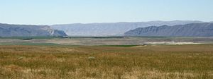
Crab Creek is a stream in the U.S. state
of Washington. Named for the presence of crayfish, it is one of the few perennial streams in the Columbia Basin of central Washington, flowing from the northeastern Columbia River Plateau
, roughly 5 km (3.1 mi) east of Reardan
, west-southwest to empty into the Columbia River
near the small town of Beverly. Its course exhibits many examples of the erosive powers of extremely large glacial Missoula Floods
of the late Pleistocene
, which scoured the region. In addition, Crab Creek and its region have been transformed by the large-scale irrigation of the Bureau of Reclamation's
Columbia Basin Project
(CBP), which has raised water table levels, significantly extending the length of Crab Creek and created new lakes and streams.
Crab Creek is 163 miles (262.3 km) long and drains a watershed
in eastern Washington of 5097 square miles (13,201.2 km²). It is sometimes referred to as the "longest ephemeral stream in North America".
, and Lower Crab Creek, which runs from Potholes Reservoir to the Columbia River. Sometimes the stream is divided into three parts—Upper Crab Creek, from its source to Brook Lake, Middle Crab Creek, from Brook Lake to and including Potholes Reservoir; and Lower Crab Creek, from below Potholes Reservoir to the Columbia River.
Upper Crab Creek was dry before the CBP and remains intermittent today. From its source near Reardan it flows generally southwest then west, collecting tributaries including Rock Creek, Coal Creek, Duck Creek, Canniwai Creek, and Wilson Creek. It empties into Brook Lake, located just south of Billy Clapp Lake, an equalizing reservoir of the CBP created by Pinto Dam.
Crab Creek turns southward after Brook Lake. The CBP's East Low Canal, one of the projects main irrigation canals, crosses but does not mix waters with Crab Creek. At the city of Moses Lake
Crab Creek empties into the Parker Horn arm of Moses Lake
. Just before reaching the lake Crab Creek receives the waters of Rocky Coulee Wasteway, a mix of the intermittent Rocky Coulee Creek and irrigation runoff from the East Low Canal. Before the CBP there was no perennial flow between Brook Lake and Moses Lake. Only during periods of high water did Crab Creek flow through this area.
Moses Lake empties into Potholes Reservoir, which feeds irrigation canals to the south. Below O'Sullivan Dam several springs renew Crab Creek, which flows southwest, then west along the north side of the Saddle Mountains to empty into the Columbia River.
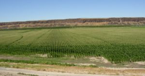
The Columbia Basin Project in central Washington changed the character of Crab Creek substantially. The Crab Creek irrigation-return drainage basin covers an irrigated area of 296 mi² (767 km²). A large earthfill dam, the O'Sullivan Dam
(also referred to as the Potholes Dam) was constructed from 1947 to 1949, forming Potholes Reservoir, which serves as a central point in the CBP for storage of irrigation water, natural runoff, and irrigation-return flow, allowing irrigation water reuse throughout the southern CBP area. Potholes Reservoir releases water through canals and has no perennial outlet to Lower Crab Creek. Hence today the water in Lower Crab Creek comes from ground-water seepage from Potholes Reservoir and irrigation, from the Goose Lake Wasteway, and from tributary inflows downstream of the O’Sullivan Dam.
 Since it is one of the few creeks in the region with reliable water, Spokane
and Palouse
Indians roamed along Crab Creek to gather roots and other food. A main Indian trail through the region followed the creek. Lt. Symons came past the mid-Crab Creek area while laying out the Military Wagon Road from Fort Walla Walla
to Camp Chelan in 1879. The Old Wagon Road was established along the creek from Waterville, Washington
to Ritzville, Washington
in 1888.
Prior to establishing irrigation, most of the areas along Upper Crab Creek were bunchgrass prairie, which was suited to range cattle and sheep. Crab Creek and tributary creeks provided water for the herds. Although a handful of ranchers ran herds, shipping their bunchgrass-fed beef to Montana by rail from towns like Sprague
, settlement remained extremely sparse. One such example was George Lucas, an Irish emigrant, who was Adams County's first permanent white settler. He established a way-station and raised cattle and horses at Cow Creek along the road to Fort Colville
in 1869.
Lower Crab Creek provided the only available water in that shrub-steppe
region and so became the nucleus of settlement. Ben and Sam Hutchinson built the first recorded cabin along Lower Crab Creek in 1884. Tom McManamon, a cattle rancher, arrived shortly thereafter, with the first homesteaders arriving in 1901 and the town of Othello being established in 1904.
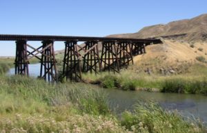
When the Bureau of Reclamation located district offices in Othello in 1947 and built the Columbia Irrigation Project, the nature of the until then sparsely populated country changed dramatically.
 The Okanogan lobe of the Cordilleran Glacier
moved down the Okanogan River
valley and blocked the ancient route of the Columbia River
, backing up water to create Lake Spokane. As the Okanogan lobe grew the Columbia was rerouted into the Grand Coulee
. Flowing across the current Grand Coulee-Dry Falls
region, the ice-age Columbia then entered the Quincy Basin near Quincy, Washington
& joined Crab Creek at Moses Lake, following Crab Creek’s course southward past the Frenchman Hills and turning west to run along the north face of the Saddle Mountains, there to rejoin the previous and modern course of the Columbia River just above the main water gap in the Saddle Mountains, Sentinel Gap.
During this period the Missoula Floods periodically discharged large volumes of water, some of which reached Upper Crab Creek by overtopping the divide between the Columbia drainage and the Crab Creek drainage, and some diverted into the Columbia River to enter Crab Creek at Moses Lake. As a result, substantial coulees and scablands were created in the Upper Crab Creek drainage, and the drainage below the Potholes Reservoir is overlarge (i.e., the channel sizes could contain a substantially larger river than currently flows there).
 Potholes State Park is a 640 acres (259 ha) park on the shore of the Potholes Reservoir. It provides ready access to the Drumheller Channels National Natural Landmark
which lies just downstream of the O’Sullivan Dam. This National Natural Landmark
is an extensively eroded channeled scablands
landscape, characterized by hundreds of isolated, steep-sided hills (buttes) surrounded by a braided network of numerous channels. All but the channel through which Crab Creek flows are currently dry. It is a classic example of the tremendous erosive powers of extremely large floods such as those that reformed the Columbia Plateau volcanic terrain during the late Pleistocene
glacial Missoula Floods
.
 There are five wildlife areas found along Crab Creek:
U.S. state
A U.S. state is any one of the 50 federated states of the United States of America that share sovereignty with the federal government. Because of this shared sovereignty, an American is a citizen both of the federal entity and of his or her state of domicile. Four states use the official title of...
of Washington. Named for the presence of crayfish, it is one of the few perennial streams in the Columbia Basin of central Washington, flowing from the northeastern Columbia River Plateau
Columbia River Plateau
The Columbia Plateau is a geologic and geographic region that lies across parts of the U.S. states of Washington, Oregon, and Idaho. It is a wide flood basalt plateau between the Cascade Range and the Rocky Mountains, cut through by the Columbia River...
, roughly 5 km (3.1 mi) east of Reardan
Reardan, Washington
Reardan is a town in Lincoln County, Washington, United States. The population was 571 at the 2010 census.-History:Founded in 1882 and platted in 1889, Reardan was named for Central Washington Railroad engineer C.F. Reardan...
, west-southwest to empty into the Columbia River
Columbia River
The Columbia River is the largest river in the Pacific Northwest region of North America. The river rises in the Rocky Mountains of British Columbia, Canada, flows northwest and then south into the U.S. state of Washington, then turns west to form most of the border between Washington and the state...
near the small town of Beverly. Its course exhibits many examples of the erosive powers of extremely large glacial Missoula Floods
Missoula Floods
The Missoula Floods refer to the cataclysmic floods that swept periodically across eastern Washington and down the Columbia River Gorge at the end of the last ice age. The glacial flood events have been researched since the 1920s...
of the late Pleistocene
Pleistocene
The Pleistocene is the epoch from 2,588,000 to 11,700 years BP that spans the world's recent period of repeated glaciations. The name pleistocene is derived from the Greek and ....
, which scoured the region. In addition, Crab Creek and its region have been transformed by the large-scale irrigation of the Bureau of Reclamation's
United States Bureau of Reclamation
The United States Bureau of Reclamation , and formerly the United States Reclamation Service , is an agency under the U.S...
Columbia Basin Project
Columbia Basin Project
The Columbia Basin Project in Central Washington, USA, is the irrigation network that the Grand Coulee Dam makes possible. It is the largest water reclamation project in the United States, supplying irrigation water to over of the large project area, all of which was originally intended to be...
(CBP), which has raised water table levels, significantly extending the length of Crab Creek and created new lakes and streams.
Crab Creek is 163 miles (262.3 km) long and drains a watershed
Drainage basin
A drainage basin is an extent or an area of land where surface water from rain and melting snow or ice converges to a single point, usually the exit of the basin, where the waters join another waterbody, such as a river, lake, reservoir, estuary, wetland, sea, or ocean...
in eastern Washington of 5097 square miles (13,201.2 km²). It is sometimes referred to as the "longest ephemeral stream in North America".
Course
Crab Creek is sometimes separated into Upper Crab Creek, which runs from the creek's source to Potholes ReservoirPotHoles Reservoir
The Potholes Reservoir is part of the Columbia Basin Irrigation Project. It is formed by the O'Sullivan Dam and located in central Washington, in the United States. The reservoir is fed by water from Moses Lake, part of the Crab Creek basin....
, and Lower Crab Creek, which runs from Potholes Reservoir to the Columbia River. Sometimes the stream is divided into three parts—Upper Crab Creek, from its source to Brook Lake, Middle Crab Creek, from Brook Lake to and including Potholes Reservoir; and Lower Crab Creek, from below Potholes Reservoir to the Columbia River.
Upper Crab Creek was dry before the CBP and remains intermittent today. From its source near Reardan it flows generally southwest then west, collecting tributaries including Rock Creek, Coal Creek, Duck Creek, Canniwai Creek, and Wilson Creek. It empties into Brook Lake, located just south of Billy Clapp Lake, an equalizing reservoir of the CBP created by Pinto Dam.
Crab Creek turns southward after Brook Lake. The CBP's East Low Canal, one of the projects main irrigation canals, crosses but does not mix waters with Crab Creek. At the city of Moses Lake
Moses Lake, Washington
Moses Lake is a city in Grant County, Washington, United States. The population was 20,366 as of the 2010 census. Moses Lake is the largest city in Grant County.-Background:...
Crab Creek empties into the Parker Horn arm of Moses Lake
Moses Lake
Moses Lake is a lake and reservoir along the course of Crab Creek, in Washington state, USA.Moses Lake is part of the Columbia River basin, as Crab Creek is a tributary of the Columbia River....
. Just before reaching the lake Crab Creek receives the waters of Rocky Coulee Wasteway, a mix of the intermittent Rocky Coulee Creek and irrigation runoff from the East Low Canal. Before the CBP there was no perennial flow between Brook Lake and Moses Lake. Only during periods of high water did Crab Creek flow through this area.
Moses Lake empties into Potholes Reservoir, which feeds irrigation canals to the south. Below O'Sullivan Dam several springs renew Crab Creek, which flows southwest, then west along the north side of the Saddle Mountains to empty into the Columbia River.
Lakes
Before 1904, drifting sand dunes blocked Crab Creek below Moses Lake, the largest natural lake on the creek. The creek's water did not reach the Columbia River. A large flood in 1904 washed through the dunes, lowering the lake by eight feet. Before the 1904 flood Crab Creek and Moses Lake's connection to the Columbia was intermittent. Fish native to Moses Lake indicate some periods of connection before 1904. It is possible that sand dunes created Moses Lake by blocking Crab Creek.The Columbia Basin Project in central Washington changed the character of Crab Creek substantially. The Crab Creek irrigation-return drainage basin covers an irrigated area of 296 mi² (767 km²). A large earthfill dam, the O'Sullivan Dam
O'Sullivan Dam
O'Sullivan Dam, one of the larger earthfill dams in the United States , is on Crab Creek in the U.S. state of Washington, about 45 km south of Ephrata and 25 km south of Moses Lake...
(also referred to as the Potholes Dam) was constructed from 1947 to 1949, forming Potholes Reservoir, which serves as a central point in the CBP for storage of irrigation water, natural runoff, and irrigation-return flow, allowing irrigation water reuse throughout the southern CBP area. Potholes Reservoir releases water through canals and has no perennial outlet to Lower Crab Creek. Hence today the water in Lower Crab Creek comes from ground-water seepage from Potholes Reservoir and irrigation, from the Goose Lake Wasteway, and from tributary inflows downstream of the O’Sullivan Dam.
History
Spokane (tribe)
The Spokane are a Native American people in the northeastern portion of the U.S. state of Washington. The Spokane Indian Reservation, at , is located in eastern Washington, almost entirely in Stevens County, but includes two very small parcels of land and part of the Spokane River in...
and Palouse
Palus (tribe)
The Palus are a Sahaptin tribe recognized in the Treaty of 1855 with the Yakamas . A variant spelling is Palouse, which was the source of the name for the fertile prairie of Washington and Idaho.- Ethnography :...
Indians roamed along Crab Creek to gather roots and other food. A main Indian trail through the region followed the creek. Lt. Symons came past the mid-Crab Creek area while laying out the Military Wagon Road from Fort Walla Walla
Fort Walla Walla
Fort Walla Walla is a fort located in Walla Walla, Washington. It was established in 1858. Today, the complex contains a park, a museum, and a hospital.Fort Walla Walla should be distinguished from Fort Nez Percés or Old Fort Walla Walla ....
to Camp Chelan in 1879. The Old Wagon Road was established along the creek from Waterville, Washington
Waterville, Washington
Waterville is a town in and the county seat of Douglas County, Washington, United States. It is part of the Wenatchee–East Wenatchee Metropolitan Statistical Area. The population was 1,138 at the 2010 census.-History:...
to Ritzville, Washington
Ritzville, Washington
Ritzville is a city in Adams County, Washington, United States. The population was 1,673 at the 2010 census. It is the county seat of Adams County.-History:...
in 1888.
Prior to establishing irrigation, most of the areas along Upper Crab Creek were bunchgrass prairie, which was suited to range cattle and sheep. Crab Creek and tributary creeks provided water for the herds. Although a handful of ranchers ran herds, shipping their bunchgrass-fed beef to Montana by rail from towns like Sprague
Sprague, Washington
Sprague is a city in Lincoln County, Washington, United States. The population was 446 at the 2010 census. The town was plotted in 1880 and named for former American Civil War Union general John Wilson Sprague.Eugene E...
, settlement remained extremely sparse. One such example was George Lucas, an Irish emigrant, who was Adams County's first permanent white settler. He established a way-station and raised cattle and horses at Cow Creek along the road to Fort Colville
Fort Colville
The trade center Fort Colville was built by the Hudson's Bay Company at Kettle Falls on the Columbia River, a few miles west of the present site of Colville, Washington in 1825, to replace Spokane House as a regional trading center, as the latter was deemed to be too far from the Columbia River...
in 1869.
Lower Crab Creek provided the only available water in that shrub-steppe
Shrub-steppe
Shrub-steppe is a type of low rainfall natural grassland. Shrub-steppes are distinguishable from deserts, which are too dry to support a noticeable cover of perennial grasses or other shrubs, while the shrub-steppe has sufficient moisture levels to support a cover of perennial grasses and/or...
region and so became the nucleus of settlement. Ben and Sam Hutchinson built the first recorded cabin along Lower Crab Creek in 1884. Tom McManamon, a cattle rancher, arrived shortly thereafter, with the first homesteaders arriving in 1901 and the town of Othello being established in 1904.
When the Bureau of Reclamation located district offices in Othello in 1947 and built the Columbia Irrigation Project, the nature of the until then sparsely populated country changed dramatically.
Geologic history
Cordilleran Ice Sheet
The Cordilleran ice sheet was a major ice sheet that covered, during glacial periods of the Quaternary, a large area of North America. This included the following areas:*Western Montana*The Idaho Panhandle...
moved down the Okanogan River
Okanogan River
The Okanogan River is a tributary of the Columbia River, approximately 115 mi long, in southern British Columbia and north central Washington...
valley and blocked the ancient route of the Columbia River
Columbia River
The Columbia River is the largest river in the Pacific Northwest region of North America. The river rises in the Rocky Mountains of British Columbia, Canada, flows northwest and then south into the U.S. state of Washington, then turns west to form most of the border between Washington and the state...
, backing up water to create Lake Spokane. As the Okanogan lobe grew the Columbia was rerouted into the Grand Coulee
Grand Coulee
The Grand Coulee is an ancient river bed in the U.S. state of Washington. This National Natural Landmark stretches for about sixty miles southwest from Grand Coulee Dam to Soap Lake, being bisected by Dry Falls into the Upper and Lower Grand Coulee....
. Flowing across the current Grand Coulee-Dry Falls
Dry Falls
Dry Falls is a 3.5 mile long scalloped precipice in central Washington, on the opposite side of the Upper Grand Coulee from the Columbia River, and at the head of the Lower Grand Coulee. Ten times the size of Niagara, Dry Falls is thought to be the greatest known waterfall that ever existed...
region, the ice-age Columbia then entered the Quincy Basin near Quincy, Washington
Quincy, Washington
Quincy Washington Quincy is a city in Grant County, Washington, United States. The population was 6,750 at the 2010 census.-History:...
& joined Crab Creek at Moses Lake, following Crab Creek’s course southward past the Frenchman Hills and turning west to run along the north face of the Saddle Mountains, there to rejoin the previous and modern course of the Columbia River just above the main water gap in the Saddle Mountains, Sentinel Gap.
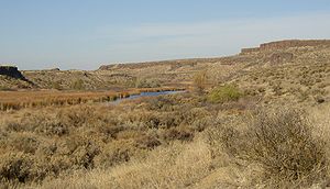
During this period the Missoula Floods periodically discharged large volumes of water, some of which reached Upper Crab Creek by overtopping the divide between the Columbia drainage and the Crab Creek drainage, and some diverted into the Columbia River to enter Crab Creek at Moses Lake. As a result, substantial coulees and scablands were created in the Upper Crab Creek drainage, and the drainage below the Potholes Reservoir is overlarge (i.e., the channel sizes could contain a substantially larger river than currently flows there).
Recreation
Drumheller Channels National Natural Landmark
Drumheller Channels National Natural Landmark showcases the Drumheller Channels, which are the most significant example in the Columbia Plateau of basalt butte-and-basin channeled scablands...
which lies just downstream of the O’Sullivan Dam. This National Natural Landmark
National Natural Landmark
The National Natural Landmark program recognizes and encourages the conservation of outstanding examples of the natural history of the United States. It is the only natural areas program of national scope that identifies and recognizes the best examples of biological and geological features in...
is an extensively eroded channeled scablands
Channeled scablands
The Channeled Scablands are a unique geological erosion feature in the U.S. state of Washington. They were created by the cataclysmic Missoula Floods that swept periodically across eastern Washington and down the Columbia River Plateau during the Pleistocene epoch. Geologist J Harlen Bretz coined...
landscape, characterized by hundreds of isolated, steep-sided hills (buttes) surrounded by a braided network of numerous channels. All but the channel through which Crab Creek flows are currently dry. It is a classic example of the tremendous erosive powers of extremely large floods such as those that reformed the Columbia Plateau volcanic terrain during the late Pleistocene
Pleistocene
The Pleistocene is the epoch from 2,588,000 to 11,700 years BP that spans the world's recent period of repeated glaciations. The name pleistocene is derived from the Greek and ....
glacial Missoula Floods
Missoula Floods
The Missoula Floods refer to the cataclysmic floods that swept periodically across eastern Washington and down the Columbia River Gorge at the end of the last ice age. The glacial flood events have been researched since the 1920s...
.
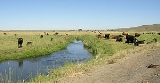
- Crab Creek Wildlife Area runs from the Columbia River east along the north face of the Saddle MountainsSaddle MountainsThe Saddle Mountains consists of an upfolded anticline ridge of basalt in Grant County of central Washington state. The ridge, reaching to 2,700 feet, terminates in the east south of Othello, Washington near the foot of the Drumheller Channels...
until Othello, WashingtonOthello, WashingtonOthello is a city in Adams County, Washington, United States. The population was 5,847 at the 2000 census and grew 25.9% over the next decade to 7,364 at the 2010 census. Othello refers to the city as being in the "Heart" of the Columbia Basin Project...
. - Seep Lakes Wildlife Area is colocated with Drumheller Channels National Natural Landmark.
- Potholes Wildlife Area is adjacent to Potholes Reservoir.
- Gloyd Seeps Wildlife Area is north of Moses Lake.
- North Columbia Basin Wildlife Area - Gloyd Seeps is north of Gloyd Seeps Wildlife Area