
Transportation in Lancaster County, Pennsylvania
Encyclopedia
Transportation in Lancaster County, Pennsylvania
has a long and variegated history. An early-settled part of the United States
, and lying on the route between Philadelphia
and Harrisburg
, it has been the site of early experiments in canals, railroads, and highways. Before all these, at least ten Native American
paths
crossed parts of the county, many connecting with the Susquehannock
village of Conestoga.
is the Susquehanna River, which forms its western border. However, its many rocks and rapids made it difficult for navigation. An attempt was made in 1820 by James Hopkins to dig a canal to bypass the Conewago Falls, already bypassed in 1797 by the Conewago Canal
in York County on the opposite side of the river. However, the Hopkins Canal was poorly laid out and not useful for navigation. He was then authorized by the legislature to build a canal along the Conestoga River
to Lancaster
to connect that city with the Susquehanna, but abandoned it after building one lock.
On March 3, 1825, the Conestoga Navigation Company was incorporated to make a second attempt at improving the Conestoga River. It was placed into operation in 1826. The Conestoga Navigation was 18 miles (29 km) long, with nine locks and dams, between Safe Harbor
, at the mouth of the creek, and Lancaster.
 Interest in improving the Susquehanna continued. Surveys were made along the east bank from Chickies Rock to the Maryland state line in 1827; the extension of the Eastern Division of the Pennsylvania Canal
to Columbia was authorized on March 24, 1828 and again on March 21, 1831, and was completed on December 4, 1832. Revenue service began on April 9, 1833. The construction of the Philadelphia and Columbia Railroad (vide infra) placed Columbia on the route from Philadelphia into the western parts of the state, via the canal. The Susquehanna and Tidewater Canal
to Baltimore was ultimately opened in 1840 on the west side of the river, canal boats crossing at Columbia to reach the Pennsylvania Canal.
By this time, the Conestoga Navigation was already in financial difficulties, and was sold to the Lancaster & Susquehanna Slack-water Navigation Company. The newly-built (1838) rail line from Harrisburg to Lancaster allowed westward trade to bypass the canals, and by 1849, the Eastern Division was entirely paralleled by rail. The state sold the Main Line of Public Works
to the Pennsylvania Railroad
in 1857, which kept the canals in desultory operation. The former Columbia Navigation last collected lock fees in 1872; its dams were later used for hydropower
in the early 20th century. The last operating segment of the Pennsylvania Canal, from Columbia northward to Nanticoke
, was abandoned on April 11, 1901.
Of the nine original Conestoga Navigation locks between Lancaster and the Susquehanna River, Lock 6 is the only survivor. Maintained by the Safe Harbor Water Power Corporation, it can be seen at Conestoga Creek Park near Safe Harbor. Railroad fill and construction has essentially obliterated the Pennsylvania Canal within the county.
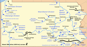
, a combined rail and canal system connecting Philadelphia and Pittsburgh
. In these early days, it was looked upon as a sort of public highway, and private horses and wagons that fit the gauge could be used on the line until 1844. Today this might be called open access
.
The Philadelphia and Columbia quickly inspired connecting lines. In 1836, the Harrisburg, Portsmouth, Mount Joy and Lancaster Railroad built a connecting line from Dillerville
, just west of Lancaster, to Mount Joy
. Building from both ends, the line was completed from Dillerville to Harrisburg in 1838. This bypassed the canal between Harrisburg and Columbia. The P&C also encouraged the businessmen of Strasburg
, who built the Strasburg Railroad from the Philadelphia and Columbia at Leaman Place
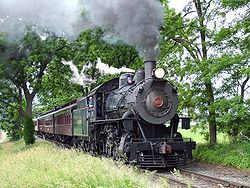
to Strasburg in 1837. Transformed from a freight line to a tourist railroad in the 1950s, it is now one of the county's most popular tourist attractions.
In 1849, the HPMt.J&L RR was taken over by the Pennsylvania Railroad
, then constructing an all-rail route across the state. It also bought the Marietta and Portsmouth Railroad, under whose charter it built a branch, paralleling the river and canal, from Royalton
to Columbia. Besides the canal, the Philadelphia and Columbia (and the new branch from Royalton) connected to the Columbia-Wrightsville Bridge
, which provided rail access to the Northern Central Railway
via the Wrightsville, York and Gettsyburg Railroad.
The PRR was forced to use the Philadelphia and Columbia between Dillerville and Philadelphia, and the sometimes lackadaisical operation of the state-run railroad proved burdensome and a bottleneck to traffic. In 1853, the PRR arranged to lease the Lancaster, Lebanon and Pine Grove Railroad, an as-yet unbuilt line from Philadelphia to Salunga via Phoenixville
, and threatened to bypass the State line entirely. The threat, and intensive lobbying, was ultimately successful in persuading the State to sell the entire Main Line of Public Works to the PRR in 1857. The PRR sold its interest in the LL&PG the following year, and the line would never be built.
 The PRR also formally leased the HPMt.J&L RR in 1861, giving it complete control over its line from Philadelphia to Pittsburgh. This line would provide valuable service during the Civil War
, particularly when the Philadelphia, Wilmington and Baltimore Railroad
came under attack from Confederates and saboteurs or was simply jammed with traffic. Troops could be sent via the PRR to Columbia, cross the Columbia-Wrightsville Bridge, and ride down the Northern Central to Baltimore. However, Lee's
invasion of Pennsylvania forced the state militia to retreat across the Columbia-Wrightsville Bridge and burn it behind them on June 28, 1863. While the destruction of the bridge saved the county from a Confederate invasion, it cut off access to the markets of York County
, and it was not replaced until several years after the war.
During the Civil War, a new railroad appeared on the scene in Lancaster County. Controlled by the Philadelphia and Reading Rail Road
, the Reading and Columbia Railroad built down from the Reading
area to reach Columbia, crossing the PRR at Landisville, with a branch from Lancaster Jct. to Lancaster. The Columbia and Port Deposit Railroad
also proposed to enter the county from the south, following the Susquehanna, but its construction was long stalled by inadequate funds and the difficult, rocky bluffs along the river.
While the principal arteries of the Lancaster County railroads had mostly been completed by this time, the Gilded Age
witnessed a period of independent railroad construction, speculation, and financial maneuvers. The Lancaster and Reading Narrow Gauge Railroad was chartered in 1871 to build a 4 in 0 in (1.22 m) gauge route from Safe Harbor
to Lancaster to Reading, with a branch from Lancaster to Quarryville
, competing with the Reading & Columbia. Construction began on the branch line to Quarryville, but was quickly changed to standard gauge. Hindered by the Panic of 1873
, the company struck a deal with the Philadelphia & Reading to complete the line from Lancaster to Quarryville in return for control of the company, which it did in the following year. It thus became an extension of the Reading's Lancaster Branch. In 1876, the East Brandywine and Waynesburg Railroad built into the county from the east to reach the prosperous agricultural town of New Holland
, and was promptly leased by the PRR. In 1877, the Columbia and Port Deposit, under control of the Philadelphia, Wilmington and Baltimore Railroad
, finally finished its line into Columbia.
1878 saw the construction of one of the more implausible railroads of the area, the Peach Bottom Railway
. Born of the "narrow-gauge fever" then sweeping the country, it was conceived as a 3 in 0 in (0.9144 m) gauge line from Philadelphia to the Broad Top coal fields. Surprisingly, the Eastern Division of the line was constructed from Oxford
into Lancaster County, ending on the banks of the Susquehanna at Peach Bottom
; no bridge was ever built to the Middle Division across the river, which would become the Maryland and Pennsylvania Railroad
. Subsisting on sparse local traffic, the Eastern Division was sold at a bankruptcy auction in September 1881 and reorganized as the Peach Bottom Railroad. Another chimerical dream of this period was the Hanover Junction and Susquehanna Railroad. Intended to run from Landisville across the river to Hanover Junction
on the Northern Central, it was reorganized in 1881 as the Reading, Marietta and Hanover Railroad, under the control of the Reading and Columbia, and produced only a short line built in 1883 from Marietta Jct. to the PRR's Columbia Branch at the foot of Chickies Rock and the dying iron furnaces there.
A more substantial result was achieved by the construction, in the same year, of the Cornwall and Mount Hope Railroad from the massive iron ore pits at Cornwall
, in Lebanon County
, to Mount Hope and a connection with the Reading & Columbia (which had built a spur there from Manheim a few years previous). It was controlled by the Cornwall Railroad, one of two competing lines from Cornwall to Lebanon
; the other was the Cornwall and Lebanon Railroad, which set about its own southward extension at the same time. Its subsidiary, the Colebrook Valley Railroad completed a line from Cornwall to Conewago Jct., on the PRR main line, the following year. It was merged into the Cornwall & Lebanon in 1886.
In 1888, the East Brandywine & Waynesburg was foreclosed and reorganized as the Downingtown and Lancaster Railroad, still controlled by the PRR. It extended from New Holland into Lancaster in 1890, creating a rural bypass of the main line from Downingtown
to Lancaster. About this time, the PRR faced a threat to its relative dominance in Lancaster County. The Peach Bottom was sold to a group of Lancaster businessmen and reorganized in 1890 as the Lancaster, Oxford and Southern Railroad. The new owners hoped to use it as part of a bridge line which would allow the Baltimore and Ohio Railroad
to enter Lancaster. The B&O would build north from Singerly to reach the Peach Bottom at Oxford. The Peach Bottom would be converted to standard gauge and build a branch from Fairmont to Quarryville. From there, B&O trains would travel over the Lancaster & Reading Narrow Gauge to reach Lancaster. However, the plan was foiled by the poor financial state of the companies involved. At the beginning of 1900, the PRR was able to gain control of the L&RNG from the Reading, scotching the plan. Despite the failure of the grand scheme, the LO&S built the Quarryville branch anyway in 1905. This ill-advised maneuver plunged it into debt from which it would never recover.
One of the smaller lines in the county was built in 1902, when the Champion Iron and Separating Company built a spur from the Columbia and Port Deposit (by now a PRR branch) at Safe Harbor to reach their ore banks and concentrating mill near Marticville. Never successful, the company struggled along through foreclosures and reorganizations for a decade before abandonment in 1912.
 The turn of the century, however, was principally marked by the construction of the PRR's Atglen and Susquehanna Branch. This was part of the PRR's "Low-Grade Lines" project, which aimed to provide low-grade (slope) routes for freight which would bypass the congestion of major cities and the steeper grades of the Main Line. It was an engineering effort which would literally change the face of Lancaster County. With the goal of low grades always in mind, the new branch was surveyed through an empty area of southern Lancaster County, without significant industries. While it did pass near Quarryville, it did so on a high fill and did not descend to serve the town. Turning to parallel the Susquehanna River, the new route descended to join the Columbia and Port Deposit Branch at Creswell
. At Columbia, the routes diverged again, with the new line following a parallel route straighter and closer to the river than the old line. At Marietta
, the new line (under the York Haven and Rowenna Railroad charter) left the old line and the county, crossing the Susquehanna on the way to Enola
. Construction of this branch required massive cuts and fills and two high bridges at Martic Forge and Safe Harbor. Most of the work, which took several years, was performed by H.S. Kerbaugh, an important PRR contractor. The line north of Marietta was opened first, on January 1, 1905, crossing Shocks Mills Bridge
. The rest of the line opened on August 10, 1906, and the York Haven & Rowenna was merged into the PRR in the same year. It rapidly became a major freight route for the PRR.
This marked the high-water mark of railroading in Lancaster County. Consolidation and abandonment would soon ensure. The PRR bought up the Cornwall & Lebanon in 1913, and it was merged into the PRR in 1918, becoming the Lebanon Branch. The hapless Lancaster, Oxford & Southern, in and out of bankruptcy since 1910, scrapped its Quarryville branch in 1917. The rest of the railroad ceased operation in 1918, and the equipment was sold the next year. One oddity did appear in 1923: Samuel Strause opened a 3 in 0 in (0.9144 m) gauge logging operation at Penryn Park, a short portion of which extended into Lancaster County to transfer timber to the Cornwall & Mount Hope RR for shipment. This was Lancaster County's only logging line, and was sporadically active until 1936, being scrapped in 1941.
In 1930, with the iron industry at Chickies long played out, the Reading's Marietta Branch was abandoned. However, the railroad network in Lancaster County thereafter remained relatively stable until the general decline of the Northeastern railroads in the 1960s. The Cornwall & Mount Hope, long out of use, was abandoned in 1964, and part of the Mount Hope spur followed in 1971. With the formation of Conrail in 1976 and the transfer of the PRR Main Line to Amtrak
, major abandonments of little-used lines began. The Lebanon Branch and the Quarryville Branch both went at its formation, although a steep spur was built off the Atglen & Susquehanna Branch at Quarryville to reach a stub of the old branch to New Providence. The remainder of the Mount Hope spur soon followed, as did the remaining stub of the Quarryville Branch, the New Holland Branch east of East Earl, and the Reading and Columbia from Lancaster Jct. to Columbia and from Lititz to Akron
, all by 1982. The Reading and Columbia from Landisville to Bruckarts did survive, being sold to the Landisville Terminal and Transfer Company, operating off a new connection with the Amtrak line at Landisville. In 1984, the Reading and Columbia was further trimmed back from Akron to Stevens
, near Ephrata. The final, major abandonment of the Conrail years was that of the Atglen & Susquehanna Branch from Safe Harbor to Lenover in 1989. Conrail's decision to divert Philadelphia-bound freight over the former Lebanon Valley Railroad
and Reading Company main line (to avoid interference with Amtrak) had left it with little or no traffic.
 , passenger service in Lancaster County is provided by Amtrak
, whose Keystone Corridor
passes through the county, with stops at Lancaster
, Mount Joy
and Elizabethtown
. A station is planned at Paradise
to provide connecting service with the Strasburg Railroad
, which runs passenger excursions from nearby Leaman Place
to Strasburg
.
The principal freight operator in the county is Norfolk Southern Railway
(NS), as successor to Conrail in 1999. The NS main line follows the Susquehanna River (with trackage rights
for Canadian Pacific Railway
(CPR)), and leaves the county by crossing the river on Shocks Mills Bridge
near Marietta
. NS also has trackage rights over the Keystone Corridor, to which it is connected by the Royalton Branch, which runs north along the river from the main line at Marietta, and the Columbia Branch, which runs from the Corridor at Dillerville
to the main line at Columbia
. Two other NS branches originate on the Corridor: the Lititz Secondary, which runs from Dillerville to Manheim
and ends at Lititz
, and the New Holland Industrial, which leaves the Corridor around the east end of Lancaster to run east to New Holland
and ends at East Earl.
Several short lines also operate in the county. With the exception of the Strasburg Railroad, all are freight railroads. The East Penn Railroad
(ESPN) operates on a spur off the NS branch to Manheim, and on a longer line in the northeast corner of Lancaster County into Berks County. Landisville Terminal and Transfer Company (LNTV) operates on a spur off the Amtrak line at Landisville. The Tyburn Railroad (TYBR) operates some trackage around Dillerville. Most recently, the Columbia and Reading Railway (CORY) began operating on 2.5 miles (4 km) of track in Columbia in January 2010. Excepting the Tyburn Railroad, all of these lines operated over former Reading & Columbia trackage.
. Conestoga Traction was an interurban trolley system that operated seven country routes radiating spoke-like from Lancaster, Pennsylvania, to numerous villages and towns. It ran side-of-road trolleys through Amish farm country to Coatesville, Strasburg/Quarryville, Pequea, Columbia/Marietta, Elizabethtown, Manheim/Lititz, and Ephrata/Adamstown/Terre Hill. By its connections to adjacent interurban trolley companies such as Philadelphia and West Chester (later Red Arrow and now today's SEPTA route 101), West Chester Street Railway, Schuylkill Valley Traction, Reading Transit, Hershey Transit, and Harrisburg Railways, one could ride trolleys from Philadelphia to Harrisburg, although slowly. This could be accomplished by two circuitous routes. The southern route went via West Chester-Coatesville-Lancaster-Hershey and the northern route via Norristown-Pottstown-Reading-Ephrata-Lebanon-Hershey. In the early part of the 1900s, Conestoga Traction was relatively fast and reliable transportation between towns in the days of horse drawn wagons and buggies using rutted and muddy dirt roads. CT also transported products such as milk and produce from farm to town. With its connection to Hershey Transit, milk was shipped by trolley to the Hershey chocolate factory. Most interurbans like CT did not survive paved highways and the Great Depression. The Conestoga Traction Manheim line, for example, was abandoned in 1932. City service in Lancaster continued until 1947.
is a transit agency operating buses serving Lancaster County, and is headquartered in downtown Lancaster.
paths (or trails) are known to have passed through what is today Lancaster County. While none of these paths are still in existence, the routes they took were often followed by later roads, canals, and railroads.
people, whose main village was Conestoga (meaning at the place of the immersed pole), in what is now Manor Township
in Lancaster County. The village of Conestoga thrived from 1690 to 1740, and was a center of trade with settler
s as early as 1696. William Penn
, James Logan
, and four colonial governors of Pennsylvania visited Conestoga. Conestoga is another name used for the Susquehannocks (primarily in Pennsylvania), while Susquehannock is used more in Maryland and points south.
Conestoga was located north of the Conestoga River
and east of the Susquehanna River
, about 4 miles (6 km) southwest of the borough
of Millersville
. Washington Boro to the northwest is the closest modern village
to the location of Conestoga, while the village of Safe Harbor lies to the south (at the confluence
of the Conestoga River with the Susquehanna). Today the hamlet
of Indiantown is probably at the actual location of Conestoga.
From the village of Conestoga, six or seven paths led in several directions.
The Great Minquas Path
went east from Conestoga to the Dutch
, Swedish, and later British
settlements in the Philadelphia and Chester
area. Minquas is the Dutch name for the Susquehannocks (from the Lenape
for treacherous). The path went east by way of Rockhill (at the ford
of the Conestoga River) to Willow Street
, Strasburg
, and Gap
, then entered Chester County
. There it continued east via Atglen
, Parkesburg
, Mortonville, and Gradyville, crossed into Delaware County
and there led through Morton
and Lima
, where it could go south to Chester or east to Darby
, and finally to Philadelphia. Parts of U.S. Route 222 and Pennsylvania Route 741
follow the path in Lancaster County. At its eastern end, numerous branches of the path led to Chester, Philadelphia and other nearby destinations. This path was also sometimes known as the Conestoga Path.
The Conestoga - Newport Path followed the Great Minquas Path to Gap, where it branched off and led southeast to Newport, Delaware
(on the Christina River
). Pennsylvania Route 41
and State Route 41 (Delaware) follow the route of the path from Gap southeast to Newport today.
The French Creek Path led northeast from Conestoga along the Conestoga River to Lancaster
, then east to Phoenixville
in Chester County. From Lancaster the path followed the Conestoga River to Eden then left the river and went east through New Holland
and Blue Ball, before entering Berks County
, where it passed through Morgantown. It then entered Chester County and went through Elverson
and Warwick to French Creek
, which it followed to Bucktown and finally Phoenixville (on the Schuylkill River
). Pennsylvania Route 999
follows the course of this path to Lancaster, and Pennsylvania Route 23
continues from there to Phoenixville. As much of this path follows the Conestoga River and French Creek, it is possible it paralleled a canoe path with a portage between these two streams.
The Blue Rock Path, according to a separate tradition, followed the French Creek Path closely from Phoenixville west to Conestoga (and may be the same path). From Conestoga, the Blue Rock Path went west to the Susquehanna River and crossed it at a ford
south of modern Washington Boro, going west to York County
.
The Monocacy Path led west from Conestoga across the Susquehanna River to York
, then southwest to Hanover
, then into Maryland
and Frederick
there (on the Monocacy River
). From Frederick one could continue southwest to the Cumberland Gap
and Kentucky
or into Virginia
. This path was also sometimes known as the Conestoga Path in Pennsylvania and the Susquehanna Path in Maryland. The Blue Rock Path was either a connector to, or extension of this path. U.S. Route 30
to York, Pennsylvania Route 116
to Hanover, and Pennsylvania Route 194
to the Maryland State line follow the Monocacy Path in Pennsylvania today.
The Paxtang Path went north from Conestoga along the Susquehanna River to Paxtang (modern Harrisburg
), then mostly followed the river north to the village of Shamokin
at modern Sunbury
. In Lancaster County it went through Washington Boro and Columbia
, past Chickies Rock, through Marietta
, Bainbridge (and the Native American village of Conoy there), and Falmouth, before entering Dauphin County
and continuing on to Paxtang. The Pennsylvania Canal and Pennsylvania Railroad
ran along the river here, and the Norfolk Southern rail line still does. In Lancaster County today, Pennsylvania Route 441
leads to Royalton, Pennsylvania
in Dauphin County along the path's route and from Royalton Pennsylvania Route 230
leads to Harrisburg (formerly Paxtang). Heading north from Paxtang, the path ended at the village of Shamokin, where the Susquehanna River forks. The Great Shamokin Path
along the West Branch Susquehanna River
led to western Pennsylvania, the Allegheny River
, and eventually Ohio
. The Great Warriors Path followed the main or North Branch of the Susquehanna River north to modern day Wilkes-Barre
and Scranton
, then north to New York
state and the Five (later Six) Nations of the Iroquois
there.
in the southwest corner of Lancaster County. Peach Bottom is in Fulton Township
, on the Susquehanna River just north of Maryland and the Mason-Dixon Line
. In addition to the path south from Conestoga, two other paths met here.
The Peach Bottom Path led west and slightly north from Peach Bottom to the village of Hayesville, in Chester County. From Peach Bottom the path went through Wakefield, Oakryn, Little Britain, Oak Hill, Tayloria, and crossed Octoraro Creek
into Chester County at Pine Grove. From there it continued west via Tweedale to Hayesville, where it connected to the Nanticoke Path running north from Calvert, Maryland
to Nanticoke, Pennsylvania
. Pennsylvania Route 272
follows the path from Wakefield to Oak Hill.
The New Castle Path ran from Peach Bottom east to New Castle, Delaware
, and was sometimes known as the Susquehanna Path. James Logan traveled this path in 1705 to Peach Bottom and north to Conestoga on his first visit there, as did Governor John Evans.
. The village was at the mouth of Conoy Creek on the Susquehanna River in the northwest corner of Lancaster County. The Paxtang Path ran through here, and two other paths met at Conoy as well.
Old Peter's Road went from the village of Conoy (modern Bainbridge) east to the village of Downington in Chester County. The name comes from Peter Bezaillon, who had a trading post and 700 acres (2.8 km²) at Conoy by 1719. The road was laid out in 1718 on Bezaillon's bridle path
, which followed an old Native American path. From Bainbridge, the path went northeast through Donegal Springs and Mount Joy
to Lancaster Junction, where it forded Chiques Creek
. Continuing east, it formed the boundary between the following sets of townships: Penn
and East Hempfield
, Warwick
and Manheim
, and West Earl
and Upper Leacock
. Fording Conestoga River
just south of the mouth of Cocalico Creek
, the path led east to Center Square, Springville, and White Horse. Crossing into Chester County, it passed through Compass, Wagontown, Siousca, and Thorndale, and reached Downington on the East Branch of Brandywine Creek. U.S. Route 30
, Pennsylvania Route 340
, Pennsylvania Route 897
, Pennsylvania Route 283
, and Pennsylvania Route 230
all follow parts of Old Peter's Road. For a time it was "the main artery between Philadelphia and the west".
The Conoy Path led west from modern Bainbridge across the Susquehanna River to modern Carlisle
in Cumberland County
. From Conoy the path followed the Paxtang Path north to a ford at the Conewago Falls in the Susquehanna River, where it crossed west to York Haven
at the mouth of Conewago Creek
in York County. There it headed west and slightly north, through Newberrytown, fording Yellow Breeches Creek
into Cumberland County near Lisburn. There it led west through Bowmansdale to the village of Letort's Spring, modern Carlisle. There was a connection there to the east-west Allegheny Path from Harrisburg to Pittsburgh
. The path is sometimes also known as the Conewago Path and the part in Lancaster County is sometimes seen as an extension of Old Peter's Road.
(or Interstate 76
), U.S. Route 30
(or the Lincoln Highway
), U.S. Route 222, and U.S. Route 322
. Pennsylvania State Routes in the county include: 10
, 23
, 41
, 72
, 230
, 241
, 272
, 283
, 324
, 340
, 372
, 441
, 462
, 472
, 501
, 625
, 741
, 743
, 772
, 896
, 897
, and 999
.
was opened on August 17, 1935, with commercial service beginning on March 28, 1949 via All American Airways
, now known as US Airways Express
. Currently operated by The Lancaster Airport Authority, the facility can be found at 500 Airport Road, Suite G, Lititz, PA 17543. The airport has had difficulty maintaining commercial service, due to low passenger volume. As of September 2007 commercial flights accounted for only 1 percent of traffic and less than 3 percent of revenue. An 18 month lapse in service took place in 2003 and 2004. In 2007, the federal government awarded $1.37 million in subsidies (via the Essential Air Service
program) to Air Midwest
, in an attempt to maintain service. Despite the heavy subsidies, Air Midwest
ended service on September 30, 2007, the date that its contract with the Lancaster Airport expired.
Smoketown Airport
, a public airport which serves general aviation
traffic, is located 6.3 miles (10.1 km) east of Lancaster. Larger and better served airports are within a short distance of Lancaster. Harrisburg International Airport
is within a 30-minute Amtrak
train ride or a 45-minute drive of the city of Lancaster. Philadelphia International Airport
is within a 60-minute Amtrak
train ride or a 1 hour, 30 minute drive of the city of Lancaster.
Pennsylvania
The Commonwealth of Pennsylvania is a U.S. state that is located in the Northeastern and Mid-Atlantic regions of the United States. The state borders Delaware and Maryland to the south, West Virginia to the southwest, Ohio to the west, New York and Ontario, Canada, to the north, and New Jersey to...
has a long and variegated history. An early-settled part of the United States
United States
The United States of America is a federal constitutional republic comprising fifty states and a federal district...
, and lying on the route between Philadelphia
Philadelphia, Pennsylvania
Philadelphia is the largest city in the Commonwealth of Pennsylvania and the county seat of Philadelphia County, with which it is coterminous. The city is located in the Northeastern United States along the Delaware and Schuylkill rivers. It is the fifth-most-populous city in the United States,...
and Harrisburg
Harrisburg, Pennsylvania
Harrisburg is the capital of Pennsylvania. As of the 2010 census, the city had a population of 49,528, making it the ninth largest city in Pennsylvania...
, it has been the site of early experiments in canals, railroads, and highways. Before all these, at least ten Native American
Native Americans in the United States
Native Americans in the United States are the indigenous peoples in North America within the boundaries of the present-day continental United States, parts of Alaska, and the island state of Hawaii. They are composed of numerous, distinct tribes, states, and ethnic groups, many of which survive as...
paths
Trail
A trail is a path with a rough beaten or dirt/stone surface used for travel. Trails may be for use only by walkers and in some places are the main access route to remote settlements...
crossed parts of the county, many connecting with the Susquehannock
Susquehannock
The Susquehannock people were Iroquoian-speaking Native Americans who lived in areas adjacent to the Susquehanna River and its tributaries from the southern part of what is now New York, through Pennsylvania, to the mouth of the Susquehanna in Maryland at the north end of the Chesapeake Bay...
village of Conestoga.
Canals
The principal waterway in Lancaster CountyLancaster County, Pennsylvania
Lancaster County, known as the Garden Spot of America or Pennsylvania Dutch Country, is a county located in the southeastern part of the Commonwealth of Pennsylvania, in the United States. As of 2010 the population was 519,445. Lancaster County forms the Lancaster Metropolitan Statistical Area, the...
is the Susquehanna River, which forms its western border. However, its many rocks and rapids made it difficult for navigation. An attempt was made in 1820 by James Hopkins to dig a canal to bypass the Conewago Falls, already bypassed in 1797 by the Conewago Canal
Conewago Canal
The Conewago Canal, on the west bank of the Susquehanna River below York Haven, Pennsylvania, south of Harrisburg in York County, enabled late 18th and early 19th century rivercraft to safely bypass rapids at Conewago Falls. Work on the canal of less than began in 1793 and was completed in 1797...
in York County on the opposite side of the river. However, the Hopkins Canal was poorly laid out and not useful for navigation. He was then authorized by the legislature to build a canal along the Conestoga River
Conestoga River
The Conestoga River, also referred to as Conestoga Creek, is a tributary of the Susquehanna River flowing through the center of Lancaster County, Pennsylvania.-Geography:...
to Lancaster
Lancaster, Pennsylvania
Lancaster is a city in the south-central part of the Commonwealth of Pennsylvania. It is the county seat of Lancaster County and one of the older inland cities in the United States, . With a population of 59,322, it ranks eighth in population among Pennsylvania's cities...
to connect that city with the Susquehanna, but abandoned it after building one lock.
On March 3, 1825, the Conestoga Navigation Company was incorporated to make a second attempt at improving the Conestoga River. It was placed into operation in 1826. The Conestoga Navigation was 18 miles (29 km) long, with nine locks and dams, between Safe Harbor
Safe Harbor, Pennsylvania
Safe Harbor, Pennsylvania is a small unincorporated community located within Conestoga Township in Lancaster County, Pennsylvania, USA.The general location was an early staging area for native American tribes traversing the Susquehanna River from the settlements surrounding Conestoga and present...
, at the mouth of the creek, and Lancaster.
Main Line of Public Works
The Main Line of Public Works was a railroad and canal system built by the Commonwealth of Pennsylvania in the 19th century. It ran from Philadelphia west through Harrisburg and across the state to Pittsburgh and connected with other divisions of the Pennsylvania Canal...
to Columbia was authorized on March 24, 1828 and again on March 21, 1831, and was completed on December 4, 1832. Revenue service began on April 9, 1833. The construction of the Philadelphia and Columbia Railroad (vide infra) placed Columbia on the route from Philadelphia into the western parts of the state, via the canal. The Susquehanna and Tidewater Canal
Susquehanna and Tidewater Canal
The Susquehanna and Tidewater Canal between Wrightsville, Pennsylvania, and Havre de Grace, Maryland, at the head of Chesapeake Bay, provided an interstate shipping alternative to 19th-century arks, rafts, and boats plying the difficult waters of the lower Susquehanna River...
to Baltimore was ultimately opened in 1840 on the west side of the river, canal boats crossing at Columbia to reach the Pennsylvania Canal.
By this time, the Conestoga Navigation was already in financial difficulties, and was sold to the Lancaster & Susquehanna Slack-water Navigation Company. The newly-built (1838) rail line from Harrisburg to Lancaster allowed westward trade to bypass the canals, and by 1849, the Eastern Division was entirely paralleled by rail. The state sold the Main Line of Public Works
Main Line of Public Works
The Main Line of Public Works was a railroad and canal system built by the Commonwealth of Pennsylvania in the 19th century. It ran from Philadelphia west through Harrisburg and across the state to Pittsburgh and connected with other divisions of the Pennsylvania Canal...
to the Pennsylvania Railroad
Pennsylvania Railroad
The Pennsylvania Railroad was an American Class I railroad, founded in 1846. Commonly referred to as the "Pennsy", the PRR was headquartered in Philadelphia, Pennsylvania....
in 1857, which kept the canals in desultory operation. The former Columbia Navigation last collected lock fees in 1872; its dams were later used for hydropower
Hydropower
Hydropower, hydraulic power, hydrokinetic power or water power is power that is derived from the force or energy of falling water, which may be harnessed for useful purposes. Since ancient times, hydropower has been used for irrigation and the operation of various mechanical devices, such as...
in the early 20th century. The last operating segment of the Pennsylvania Canal, from Columbia northward to Nanticoke
Nanticoke, Pennsylvania
Nanticoke is a city in Luzerne County, Pennsylvania, United States. The population was 10,465 at the 2010 census.-History:The name Nanticoke was derived from Nantego, the Indian tidewater people who moved here when their Maryland lands were spoiled for hunting by the colonial settlement in...
, was abandoned on April 11, 1901.
Of the nine original Conestoga Navigation locks between Lancaster and the Susquehanna River, Lock 6 is the only survivor. Maintained by the Safe Harbor Water Power Corporation, it can be seen at Conestoga Creek Park near Safe Harbor. Railroad fill and construction has essentially obliterated the Pennsylvania Canal within the county.
Railroad history
The first railroad to pass through Lancaster County was the Philadelphia and Columbia Railroad, opened through Lancaster to the canal port of Columbia on March 31 or April 1, 1834. It was constructed by the state as part of the Main Line of Public WorksMain Line of Public Works
The Main Line of Public Works was a railroad and canal system built by the Commonwealth of Pennsylvania in the 19th century. It ran from Philadelphia west through Harrisburg and across the state to Pittsburgh and connected with other divisions of the Pennsylvania Canal...
, a combined rail and canal system connecting Philadelphia and Pittsburgh
Pittsburgh, Pennsylvania
Pittsburgh is the second-largest city in the US Commonwealth of Pennsylvania and the county seat of Allegheny County. Regionally, it anchors the largest urban area of Appalachia and the Ohio River Valley, and nationally, it is the 22nd-largest urban area in the United States...
. In these early days, it was looked upon as a sort of public highway, and private horses and wagons that fit the gauge could be used on the line until 1844. Today this might be called open access
Open Access (Infrastructure)
In the context of infrastructure, open access involves physical infrastructure such as railways and physical telecommunications network plant being made available to clients other than the owners, for a fee....
.
The Philadelphia and Columbia quickly inspired connecting lines. In 1836, the Harrisburg, Portsmouth, Mount Joy and Lancaster Railroad built a connecting line from Dillerville
Dillerville, Pennsylvania
Dillerville is an extinct hamlet in Lancaster County, Pennsylvania, United States.Dillerville was established between the Harrisburg and Manheim pikes, at the intersection of the Lancaster and Reading railroads....
, just west of Lancaster, to Mount Joy
Mount Joy, Pennsylvania
Mount Joy is a borough in Lancaster County, Pennsylvania, United States. The population was 6,765 at the 2000 census.-Name and origin:Mount Joy is often named in lists of "delightfully-named towns" in Pennsylvania Dutchland, along with Intercourse, Blue Ball, PenisPallooza, Amish Land, Dick-in-Hand...
. Building from both ends, the line was completed from Dillerville to Harrisburg in 1838. This bypassed the canal between Harrisburg and Columbia. The P&C also encouraged the businessmen of Strasburg
Strasburg, Pennsylvania
Strasburg is a borough in Lancaster County, Pennsylvania, United States. It developed as a linear village along the Great Conestoga Road, stretching about two miles along path later known as the Strasburg Road...
, who built the Strasburg Railroad from the Philadelphia and Columbia at Leaman Place
Leaman Place, Pennsylvania
Leaman Place is a named place in Lancaster County, Pennsylvania, United States. Leaman Place is known mostly as a whistle-stop. President Abraham Lincoln spoke at this station on February 22, 1861 to a crowd of 5,000. In 1968, Democrat Hubert H...
to Strasburg in 1837. Transformed from a freight line to a tourist railroad in the 1950s, it is now one of the county's most popular tourist attractions.
In 1849, the HPMt.J&L RR was taken over by the Pennsylvania Railroad
Pennsylvania Railroad
The Pennsylvania Railroad was an American Class I railroad, founded in 1846. Commonly referred to as the "Pennsy", the PRR was headquartered in Philadelphia, Pennsylvania....
, then constructing an all-rail route across the state. It also bought the Marietta and Portsmouth Railroad, under whose charter it built a branch, paralleling the river and canal, from Royalton
Royalton, Pennsylvania
Royalton is a borough in Dauphin County, Pennsylvania, United States. As of the 2003 census, the borough population was 963. It is part of the Harrisburg–Carlisle Metropolitan Statistical Area.-Geography:...
to Columbia. Besides the canal, the Philadelphia and Columbia (and the new branch from Royalton) connected to the Columbia-Wrightsville Bridge
Pennsylvania Railroad Bridge (Columbia, Pennsylvania)
The Pennsylvania Railroad Bridge once carried the York Branch of the Pennsylvania Railroad across the Susquehanna River between Columbia and Wrightsville, Pennsylvania and is therefore considered a Columbia-Wrightsville Bridge...
, which provided rail access to the Northern Central Railway
Northern Central Railway
The Northern Central Railway was a Class I Railroad connecting Baltimore, Maryland with Sunbury, Pennsylvania. Completed in 1858, the line came under the control of the Pennsylvania Railroad in 1861, when the PRR acquired a controlling interest in the Northern Central's stock to compete with the...
via the Wrightsville, York and Gettsyburg Railroad.
The PRR was forced to use the Philadelphia and Columbia between Dillerville and Philadelphia, and the sometimes lackadaisical operation of the state-run railroad proved burdensome and a bottleneck to traffic. In 1853, the PRR arranged to lease the Lancaster, Lebanon and Pine Grove Railroad, an as-yet unbuilt line from Philadelphia to Salunga via Phoenixville
Phoenixville, Pennsylvania
Phoenixville is a borough in Chester County, Pennsylvania, United States, northwest of Philadelphia, at the junction of French Creek with the Schuylkill River. The population is 16,440 as of the 2010 Census.- History :...
, and threatened to bypass the State line entirely. The threat, and intensive lobbying, was ultimately successful in persuading the State to sell the entire Main Line of Public Works to the PRR in 1857. The PRR sold its interest in the LL&PG the following year, and the line would never be built.
American Civil War
The American Civil War was a civil war fought in the United States of America. In response to the election of Abraham Lincoln as President of the United States, 11 southern slave states declared their secession from the United States and formed the Confederate States of America ; the other 25...
, particularly when the Philadelphia, Wilmington and Baltimore Railroad
Philadelphia, Wilmington and Baltimore Railroad
The Philadelphia, Wilmington and Baltimore Railroad was the Pennsylvania Railroad's main line from Philadelphia, Pennsylvania southwest to Baltimore, Maryland in the 19th and early 20th centuries...
came under attack from Confederates and saboteurs or was simply jammed with traffic. Troops could be sent via the PRR to Columbia, cross the Columbia-Wrightsville Bridge, and ride down the Northern Central to Baltimore. However, Lee's
Robert E. Lee
Robert Edward Lee was a career military officer who is best known for having commanded the Confederate Army of Northern Virginia in the American Civil War....
invasion of Pennsylvania forced the state militia to retreat across the Columbia-Wrightsville Bridge and burn it behind them on June 28, 1863. While the destruction of the bridge saved the county from a Confederate invasion, it cut off access to the markets of York County
York County, Pennsylvania
York County is a county in the U.S. state of Pennsylvania. As of 2010, the population was 434,972. It is in the Susquehanna Valley, a large fertile agricultural region in South Central Pennsylvania....
, and it was not replaced until several years after the war.
During the Civil War, a new railroad appeared on the scene in Lancaster County. Controlled by the Philadelphia and Reading Rail Road
Reading Company
The Reading Company , usually called the Reading Railroad, officially the Philadelphia and Reading Rail Road and then the Philadelphia and Reading Railway until 1924, operated in southeast Pennsylvania and neighboring states...
, the Reading and Columbia Railroad built down from the Reading
Reading, Pennsylvania
Reading is a city in southeastern Pennsylvania, USA, and seat of Berks County. Reading is the principal city of the Greater Reading Area and had a population of 88,082 as of the 2010 census, making it the fifth most populated city in the state after Philadelphia, Pittsburgh, Allentown and Erie,...
area to reach Columbia, crossing the PRR at Landisville, with a branch from Lancaster Jct. to Lancaster. The Columbia and Port Deposit Railroad
Columbia and Port Deposit Railroad
The Columbia and Port Deposit Railroad was a railroad that operated in Pennsylvania and Maryland in the 19th and early 20th centuries. It operated a main line between Columbia, Pennsylvania and Port Deposit, Maryland, generally along the eastern shore of the Susquehanna River. It later acquired...
also proposed to enter the county from the south, following the Susquehanna, but its construction was long stalled by inadequate funds and the difficult, rocky bluffs along the river.
While the principal arteries of the Lancaster County railroads had mostly been completed by this time, the Gilded Age
Gilded Age
In United States history, the Gilded Age refers to the era of rapid economic and population growth in the United States during the post–Civil War and post-Reconstruction eras of the late 19th century. The term "Gilded Age" was coined by Mark Twain and Charles Dudley Warner in their book The Gilded...
witnessed a period of independent railroad construction, speculation, and financial maneuvers. The Lancaster and Reading Narrow Gauge Railroad was chartered in 1871 to build a 4 in 0 in (1.22 m) gauge route from Safe Harbor
Safe Harbor, Pennsylvania
Safe Harbor, Pennsylvania is a small unincorporated community located within Conestoga Township in Lancaster County, Pennsylvania, USA.The general location was an early staging area for native American tribes traversing the Susquehanna River from the settlements surrounding Conestoga and present...
to Lancaster to Reading, with a branch from Lancaster to Quarryville
Quarryville, Pennsylvania
Quarryville is a borough in Lancaster County, Pennsylvania, United States. The population was 1,994 at the 2000 census.-General information:*ZIP code: 17566*Area code: 717*Local phone exchanges: 786, 806*Named for noted quarries in the area...
, competing with the Reading & Columbia. Construction began on the branch line to Quarryville, but was quickly changed to standard gauge. Hindered by the Panic of 1873
Panic of 1873
The Panic of 1873 triggered a severe international economic depression in both Europe and the United States that lasted until 1879, and even longer in some countries. The depression was known as the Great Depression until the 1930s, but is now known as the Long Depression...
, the company struck a deal with the Philadelphia & Reading to complete the line from Lancaster to Quarryville in return for control of the company, which it did in the following year. It thus became an extension of the Reading's Lancaster Branch. In 1876, the East Brandywine and Waynesburg Railroad built into the county from the east to reach the prosperous agricultural town of New Holland
New Holland, Pennsylvania
New Holland is a borough in Lancaster County in Pennsylvania, USA. The population was 5,092 at the 2000 census. New Holland was settled in 1728 by John Michael and John Phillip Ranc . Before it became known as New Holland, it had been called Hog Swamp, Earltown and New Design...
, and was promptly leased by the PRR. In 1877, the Columbia and Port Deposit, under control of the Philadelphia, Wilmington and Baltimore Railroad
Philadelphia, Wilmington and Baltimore Railroad
The Philadelphia, Wilmington and Baltimore Railroad was the Pennsylvania Railroad's main line from Philadelphia, Pennsylvania southwest to Baltimore, Maryland in the 19th and early 20th centuries...
, finally finished its line into Columbia.
1878 saw the construction of one of the more implausible railroads of the area, the Peach Bottom Railway
Peach Bottom Railway
The Peach Bottom Railway was a 19th-century narrow gauge railroad in Pennsylvania, designed to haul coal from the Broad Top fields in central Pennsylvania to Philadelphia, but succeeded only in establishing two local short lines.-Charter and plan:...
. Born of the "narrow-gauge fever" then sweeping the country, it was conceived as a 3 in 0 in (0.9144 m) gauge line from Philadelphia to the Broad Top coal fields. Surprisingly, the Eastern Division of the line was constructed from Oxford
Oxford, Pennsylvania
Oxford is a borough in Chester County, Pennsylvania, United States. Oxford is the closest town to Lincoln University. The population was 4,315 at the 2000 census.-History:The borough was once called Oxford Crossing and Oxford Village....
into Lancaster County, ending on the banks of the Susquehanna at Peach Bottom
Peach Bottom, Pennsylvania
Peach Bottom, Pennsylvania is an unincorporated village in Fulton Township, Lancaster County, in the state of Pennsylvania in the United States. It lies on the east bank of the Susquehanna River, at ....
; no bridge was ever built to the Middle Division across the river, which would become the Maryland and Pennsylvania Railroad
Maryland and Pennsylvania Railroad
The Maryland and Pennsylvania Railroad , familiarly known as the "Ma and Pa", was an American short-line railroad between York and Hanover, Pennsylvania, formerly operating passenger and freight trains on its original line between York and Baltimore, Maryland, from 1901 until the 1950s...
. Subsisting on sparse local traffic, the Eastern Division was sold at a bankruptcy auction in September 1881 and reorganized as the Peach Bottom Railroad. Another chimerical dream of this period was the Hanover Junction and Susquehanna Railroad. Intended to run from Landisville across the river to Hanover Junction
Hanover Junction, Pennsylvania
Hanover Junction is a small unincorporated community in south-central York County, Pennsylvania, United States, near the borough of Seven Valleys...
on the Northern Central, it was reorganized in 1881 as the Reading, Marietta and Hanover Railroad, under the control of the Reading and Columbia, and produced only a short line built in 1883 from Marietta Jct. to the PRR's Columbia Branch at the foot of Chickies Rock and the dying iron furnaces there.
A more substantial result was achieved by the construction, in the same year, of the Cornwall and Mount Hope Railroad from the massive iron ore pits at Cornwall
Cornwall, Pennsylvania
Cornwall is a borough in Lebanon County, Pennsylvania, United States. It is part of the Lebanon, PA Metropolitan Statistical Area. The population was 3,486 at the 2000 census.-History:...
, in Lebanon County
Lebanon County, Pennsylvania
As of the census of 2000, there were 120,327 people and 32,771 families residing in the county. The population density was 332 people per square mile . There were 49,320 housing units at an average density of 136 per square mile...
, to Mount Hope and a connection with the Reading & Columbia (which had built a spur there from Manheim a few years previous). It was controlled by the Cornwall Railroad, one of two competing lines from Cornwall to Lebanon
Lebanon, Pennsylvania
Lebanon, formerly known as Steitztown, is a city in and the county seat of Lebanon County, Pennsylvania, United States. The population was 25,477 at the 2010 census, a 4.2% increase from the 2000 count of 24,461...
; the other was the Cornwall and Lebanon Railroad, which set about its own southward extension at the same time. Its subsidiary, the Colebrook Valley Railroad completed a line from Cornwall to Conewago Jct., on the PRR main line, the following year. It was merged into the Cornwall & Lebanon in 1886.
In 1888, the East Brandywine & Waynesburg was foreclosed and reorganized as the Downingtown and Lancaster Railroad, still controlled by the PRR. It extended from New Holland into Lancaster in 1890, creating a rural bypass of the main line from Downingtown
Downingtown, Pennsylvania
Downingtown is a borough in Chester County, Pennsylvania, west of Philadelphia. As of the 2010 census it had a population of 7,891. Downingtown was settled by English and European colonists in the early 18th century and has a number of historic buildings and structures.-History:The town was...
to Lancaster. About this time, the PRR faced a threat to its relative dominance in Lancaster County. The Peach Bottom was sold to a group of Lancaster businessmen and reorganized in 1890 as the Lancaster, Oxford and Southern Railroad. The new owners hoped to use it as part of a bridge line which would allow the Baltimore and Ohio Railroad
Baltimore and Ohio Railroad
The Baltimore and Ohio Railroad was one of the oldest railroads in the United States and the first common carrier railroad. It came into being mostly because the city of Baltimore wanted to compete with the newly constructed Erie Canal and another canal being proposed by Pennsylvania, which...
to enter Lancaster. The B&O would build north from Singerly to reach the Peach Bottom at Oxford. The Peach Bottom would be converted to standard gauge and build a branch from Fairmont to Quarryville. From there, B&O trains would travel over the Lancaster & Reading Narrow Gauge to reach Lancaster. However, the plan was foiled by the poor financial state of the companies involved. At the beginning of 1900, the PRR was able to gain control of the L&RNG from the Reading, scotching the plan. Despite the failure of the grand scheme, the LO&S built the Quarryville branch anyway in 1905. This ill-advised maneuver plunged it into debt from which it would never recover.
One of the smaller lines in the county was built in 1902, when the Champion Iron and Separating Company built a spur from the Columbia and Port Deposit (by now a PRR branch) at Safe Harbor to reach their ore banks and concentrating mill near Marticville. Never successful, the company struggled along through foreclosures and reorganizations for a decade before abandonment in 1912.
Creswell, Pennsylvania
Creswell is an unincorporated community in Lancaster County, Pennsylvania, United States.-References:...
. At Columbia, the routes diverged again, with the new line following a parallel route straighter and closer to the river than the old line. At Marietta
Marietta, Pennsylvania
Marietta is a borough in Lancaster County, Pennsylvania, United States. The population was 2,689 at the 2000 census. It is located on the east bank of the Susquehanna River just north of Columbia.-Geography:Marietta is located at ....
, the new line (under the York Haven and Rowenna Railroad charter) left the old line and the county, crossing the Susquehanna on the way to Enola
Enola, Pennsylvania
Enola is a census-designated place located along the Susquehanna River in East Pennsboro Township, Cumberland County, Pennsylvania, United States. The population was 5,627 at the 2000 census. Norfolk Southern operates Enola Yard, a large rail yard and locomotive shop in Enola...
. Construction of this branch required massive cuts and fills and two high bridges at Martic Forge and Safe Harbor. Most of the work, which took several years, was performed by H.S. Kerbaugh, an important PRR contractor. The line north of Marietta was opened first, on January 1, 1905, crossing Shocks Mills Bridge
Shocks Mills Bridge
Shocks Mills Bridge carries tracks of the Norfolk Southern Railway over the Susquehanna River between Marietta, Pennsylvania and Wago Junction, Pennsylvania.-Construction:...
. The rest of the line opened on August 10, 1906, and the York Haven & Rowenna was merged into the PRR in the same year. It rapidly became a major freight route for the PRR.
This marked the high-water mark of railroading in Lancaster County. Consolidation and abandonment would soon ensure. The PRR bought up the Cornwall & Lebanon in 1913, and it was merged into the PRR in 1918, becoming the Lebanon Branch. The hapless Lancaster, Oxford & Southern, in and out of bankruptcy since 1910, scrapped its Quarryville branch in 1917. The rest of the railroad ceased operation in 1918, and the equipment was sold the next year. One oddity did appear in 1923: Samuel Strause opened a 3 in 0 in (0.9144 m) gauge logging operation at Penryn Park, a short portion of which extended into Lancaster County to transfer timber to the Cornwall & Mount Hope RR for shipment. This was Lancaster County's only logging line, and was sporadically active until 1936, being scrapped in 1941.
In 1930, with the iron industry at Chickies long played out, the Reading's Marietta Branch was abandoned. However, the railroad network in Lancaster County thereafter remained relatively stable until the general decline of the Northeastern railroads in the 1960s. The Cornwall & Mount Hope, long out of use, was abandoned in 1964, and part of the Mount Hope spur followed in 1971. With the formation of Conrail in 1976 and the transfer of the PRR Main Line to Amtrak
Amtrak
The National Railroad Passenger Corporation, doing business as Amtrak , is a government-owned corporation that was organized on May 1, 1971, to provide intercity passenger train service in the United States. "Amtrak" is a portmanteau of the words "America" and "track". It is headquartered at Union...
, major abandonments of little-used lines began. The Lebanon Branch and the Quarryville Branch both went at its formation, although a steep spur was built off the Atglen & Susquehanna Branch at Quarryville to reach a stub of the old branch to New Providence. The remainder of the Mount Hope spur soon followed, as did the remaining stub of the Quarryville Branch, the New Holland Branch east of East Earl, and the Reading and Columbia from Lancaster Jct. to Columbia and from Lititz to Akron
Akron, Pennsylvania
Akron is a borough in Lancaster County, Pennsylvania. It is a mid-sized town with two main roads going through it: Main Street and 7th Street Pennsylvania Route 272. The town is mostly residential with a number of small businesses...
, all by 1982. The Reading and Columbia from Landisville to Bruckarts did survive, being sold to the Landisville Terminal and Transfer Company, operating off a new connection with the Amtrak line at Landisville. In 1984, the Reading and Columbia was further trimmed back from Akron to Stevens
Stevens, Pennsylvania
Stevens, Pennsylvania is an unincorporated community in Lancaster County, Pennsylvania, USA. The Stevens post office is zip code 17578. Stevens was named in honor of Thaddeus Stevens.-Local businesses:...
, near Ephrata. The final, major abandonment of the Conrail years was that of the Atglen & Susquehanna Branch from Safe Harbor to Lenover in 1989. Conrail's decision to divert Philadelphia-bound freight over the former Lebanon Valley Railroad
Lebanon Valley Railroad
The Lebanon Valley Railroad is a railroad line between Harrisburg and Reading in Pennsylvania, USA. The line opened on 18 January 1858.The road was acquired by the Reading Railroad on 20 March 1858, which put them in direct competition with the Pennsylvania Railroad for the Philadelphia to...
and Reading Company main line (to avoid interference with Amtrak) had left it with little or no traffic.
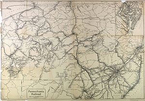
Current railroads
Amtrak
The National Railroad Passenger Corporation, doing business as Amtrak , is a government-owned corporation that was organized on May 1, 1971, to provide intercity passenger train service in the United States. "Amtrak" is a portmanteau of the words "America" and "track". It is headquartered at Union...
, whose Keystone Corridor
Keystone Corridor
The Keystone Corridor is a Federal Railroad Administration "designated high speed corridor" with a 349-mile railroad line between Philadelphia, Pennsylvania and Pittsburgh, Pennsylvania with a top speed of...
passes through the county, with stops at Lancaster
Lancaster, Pennsylvania
Lancaster is a city in the south-central part of the Commonwealth of Pennsylvania. It is the county seat of Lancaster County and one of the older inland cities in the United States, . With a population of 59,322, it ranks eighth in population among Pennsylvania's cities...
, Mount Joy
Mount Joy, Pennsylvania
Mount Joy is a borough in Lancaster County, Pennsylvania, United States. The population was 6,765 at the 2000 census.-Name and origin:Mount Joy is often named in lists of "delightfully-named towns" in Pennsylvania Dutchland, along with Intercourse, Blue Ball, PenisPallooza, Amish Land, Dick-in-Hand...
and Elizabethtown
Elizabethtown, Pennsylvania
Elizabethtown is a borough in Lancaster County, Pennsylvania, southeast of Harrisburg. Small factories existed at the turn of the century when the population in 1900 was 1,861. There was a slight increase in the next decade, with 1,970 people living in Elizabethtown in 1910. As of the 2000 census,...
. A station is planned at Paradise
Paradise, Pennsylvania
Paradise is a census-designated place in Lancaster County, Pennsylvania, United States with a zip code of 17562. The population was 1,028 at the 2000 census....
to provide connecting service with the Strasburg Railroad
Strasburg Rail Road
The Strasburg Rail Road is a heritage railroad located near Strasburg, Pennsylvania. It operates excursion trains hauled by steam locomotives in the heart of Pennsylvania Dutch Country.Across the street lies the Railroad Museum of Pennsylvania...
, which runs passenger excursions from nearby Leaman Place
Leaman Place, Pennsylvania
Leaman Place is a named place in Lancaster County, Pennsylvania, United States. Leaman Place is known mostly as a whistle-stop. President Abraham Lincoln spoke at this station on February 22, 1861 to a crowd of 5,000. In 1968, Democrat Hubert H...
to Strasburg
Strasburg, Pennsylvania
Strasburg is a borough in Lancaster County, Pennsylvania, United States. It developed as a linear village along the Great Conestoga Road, stretching about two miles along path later known as the Strasburg Road...
.
The principal freight operator in the county is Norfolk Southern Railway
Norfolk Southern Railway
The Norfolk Southern Railway is a Class I railroad in the United States, owned by the Norfolk Southern Corporation. With headquarters in Norfolk, Virginia, the company operates 21,500 route miles in 22 eastern states, the District of Columbia and the province of Ontario, Canada...
(NS), as successor to Conrail in 1999. The NS main line follows the Susquehanna River (with trackage rights
Trackage rights
Trackage rights , running rights or running powers is an agreement whereby a railway company has the right to run its trains on tracks owned by another railway company....
for Canadian Pacific Railway
Canadian Pacific Railway
The Canadian Pacific Railway , formerly also known as CP Rail between 1968 and 1996, is a historic Canadian Class I railway founded in 1881 and now operated by Canadian Pacific Railway Limited, which began operations as legal owner in a corporate restructuring in 2001...
(CPR)), and leaves the county by crossing the river on Shocks Mills Bridge
Shocks Mills Bridge
Shocks Mills Bridge carries tracks of the Norfolk Southern Railway over the Susquehanna River between Marietta, Pennsylvania and Wago Junction, Pennsylvania.-Construction:...
near Marietta
Marietta, Pennsylvania
Marietta is a borough in Lancaster County, Pennsylvania, United States. The population was 2,689 at the 2000 census. It is located on the east bank of the Susquehanna River just north of Columbia.-Geography:Marietta is located at ....
. NS also has trackage rights over the Keystone Corridor, to which it is connected by the Royalton Branch, which runs north along the river from the main line at Marietta, and the Columbia Branch, which runs from the Corridor at Dillerville
Dillerville, Pennsylvania
Dillerville is an extinct hamlet in Lancaster County, Pennsylvania, United States.Dillerville was established between the Harrisburg and Manheim pikes, at the intersection of the Lancaster and Reading railroads....
to the main line at Columbia
Columbia, Pennsylvania
Columbia, once colonial Wright's Ferry, is a borough in Lancaster County, Pennsylvania, 28 miles southeast of Harrisburg on the left bank Susquehanna River across from Wrightsville and York County. Originally, the area may have been called Conejohela Flats, for the many islands and islets in the...
. Two other NS branches originate on the Corridor: the Lititz Secondary, which runs from Dillerville to Manheim
Manheim, Pennsylvania
Manheim is a borough in Lancaster County, Pennsylvania, United States. The population was 4,784 at the 2000 census.-General information:*ZIP code: 17545*Area code: 717*Education: Manheim Central School District and Manheim Central High School-History:...
and ends at Lititz
Lititz, Pennsylvania
Lititz is a borough in Lancaster County, Pennsylvania, 6 miles north of the city of Lancaster.-History:Lititz was founded by members of the Moravian Church in 1756, and was named after a castle in Bohemia near the village of Kunvald where the ancient Bohemian Brethren's Church had...
, and the New Holland Industrial, which leaves the Corridor around the east end of Lancaster to run east to New Holland
New Holland, Pennsylvania
New Holland is a borough in Lancaster County in Pennsylvania, USA. The population was 5,092 at the 2000 census. New Holland was settled in 1728 by John Michael and John Phillip Ranc . Before it became known as New Holland, it had been called Hog Swamp, Earltown and New Design...
and ends at East Earl.
Several short lines also operate in the county. With the exception of the Strasburg Railroad, all are freight railroads. The East Penn Railroad
East Penn Railroad
The East Penn Railroad is a short-line railroad that operates a number of mostly-unconnected lines in the U.S. states of Pennsylvania and Delaware...
(ESPN) operates on a spur off the NS branch to Manheim, and on a longer line in the northeast corner of Lancaster County into Berks County. Landisville Terminal and Transfer Company (LNTV) operates on a spur off the Amtrak line at Landisville. The Tyburn Railroad (TYBR) operates some trackage around Dillerville. Most recently, the Columbia and Reading Railway (CORY) began operating on 2.5 miles (4 km) of track in Columbia in January 2010. Excepting the Tyburn Railroad, all of these lines operated over former Reading & Columbia trackage.
Trolleys
The principal trolley company in Lancaster County was the Conestoga Traction CompanyConestoga Traction Company
Conestoga Traction, later Conestoga Transportation Company, was a classic American regional interurban trolley that operated seven routes 1899 to 1946 radiating spoke-like from Lancaster, Pennsylvania to numerous neighboring farm villages and towns...
. Conestoga Traction was an interurban trolley system that operated seven country routes radiating spoke-like from Lancaster, Pennsylvania, to numerous villages and towns. It ran side-of-road trolleys through Amish farm country to Coatesville, Strasburg/Quarryville, Pequea, Columbia/Marietta, Elizabethtown, Manheim/Lititz, and Ephrata/Adamstown/Terre Hill. By its connections to adjacent interurban trolley companies such as Philadelphia and West Chester (later Red Arrow and now today's SEPTA route 101), West Chester Street Railway, Schuylkill Valley Traction, Reading Transit, Hershey Transit, and Harrisburg Railways, one could ride trolleys from Philadelphia to Harrisburg, although slowly. This could be accomplished by two circuitous routes. The southern route went via West Chester-Coatesville-Lancaster-Hershey and the northern route via Norristown-Pottstown-Reading-Ephrata-Lebanon-Hershey. In the early part of the 1900s, Conestoga Traction was relatively fast and reliable transportation between towns in the days of horse drawn wagons and buggies using rutted and muddy dirt roads. CT also transported products such as milk and produce from farm to town. With its connection to Hershey Transit, milk was shipped by trolley to the Hershey chocolate factory. Most interurbans like CT did not survive paved highways and the Great Depression. The Conestoga Traction Manheim line, for example, was abandoned in 1932. City service in Lancaster continued until 1947.
Transit
The Red Rose Transit AuthorityRed Rose Transit Authority
The Red Rose Transit Authority is a transit agency serving Lancaster County, Pennsylvania. RRTA is headquartered in downtown Lancaster.RRTA has routes both within Lancaster city, and between Lancaster and other areas of the county. RRTA coordinates a Paratransit service, Red Rose Access, which is...
is a transit agency operating buses serving Lancaster County, and is headquartered in downtown Lancaster.
Native American paths
Ten or more Native AmericanNative Americans in the United States
Native Americans in the United States are the indigenous peoples in North America within the boundaries of the present-day continental United States, parts of Alaska, and the island state of Hawaii. They are composed of numerous, distinct tribes, states, and ethnic groups, many of which survive as...
paths (or trails) are known to have passed through what is today Lancaster County. While none of these paths are still in existence, the routes they took were often followed by later roads, canals, and railroads.
Conestoga paths
Many of these paths were connected with the SusquehannockSusquehannock
The Susquehannock people were Iroquoian-speaking Native Americans who lived in areas adjacent to the Susquehanna River and its tributaries from the southern part of what is now New York, through Pennsylvania, to the mouth of the Susquehanna in Maryland at the north end of the Chesapeake Bay...
people, whose main village was Conestoga (meaning at the place of the immersed pole), in what is now Manor Township
Manor Township, Lancaster County, Pennsylvania
Manor Township is a township in west central Lancaster County, Pennsylvania, United States. Manor Township takes its name from the Manor of Conestoga, which was originally surveyed and reserved for William Penn in 1719. It was changed to its present form in 1759...
in Lancaster County. The village of Conestoga thrived from 1690 to 1740, and was a center of trade with settler
Settler
A settler is a person who has migrated to an area and established permanent residence there, often to colonize the area. Settlers are generally people who take up residence on land and cultivate it, as opposed to nomads...
s as early as 1696. William Penn
William Penn
William Penn was an English real estate entrepreneur, philosopher, and founder of the Province of Pennsylvania, the English North American colony and the future Commonwealth of Pennsylvania. He was an early champion of democracy and religious freedom, notable for his good relations and successful...
, James Logan
James Logan (statesman)
James Logan , a statesman and scholar, was born in Lurgan, County Armagh, Ireland of Scottish descent and Quaker parentage. In 1689, the Logan family moved to Bristol, England where, in 1693, James replaced his father as schoolmaster...
, and four colonial governors of Pennsylvania visited Conestoga. Conestoga is another name used for the Susquehannocks (primarily in Pennsylvania), while Susquehannock is used more in Maryland and points south.
Conestoga was located north of the Conestoga River
Conestoga River
The Conestoga River, also referred to as Conestoga Creek, is a tributary of the Susquehanna River flowing through the center of Lancaster County, Pennsylvania.-Geography:...
and east of the Susquehanna River
Susquehanna River
The Susquehanna River is a river located in the northeastern United States. At long, it is the longest river on the American east coast that drains into the Atlantic Ocean, and with its watershed it is the 16th largest river in the United States, and the longest river in the continental United...
, about 4 miles (6 km) southwest of the borough
Borough
A borough is an administrative division in various countries. In principle, the term borough designates a self-governing township although, in practice, official use of the term varies widely....
of Millersville
Millersville, Pennsylvania
Millersville is a borough in Lancaster County, Pennsylvania, United States. At the 2000 census the population was 7,774.-Geography:Millersville is located at ....
. Washington Boro to the northwest is the closest modern village
Village
A village is a clustered human settlement or community, larger than a hamlet with the population ranging from a few hundred to a few thousand , Though often located in rural areas, the term urban village is also applied to certain urban neighbourhoods, such as the West Village in Manhattan, New...
to the location of Conestoga, while the village of Safe Harbor lies to the south (at the confluence
Confluence (geography)
In geography, a confluence is the meeting of two or more bodies of water. It usually refers to the point where two streams flow together, merging into a single stream...
of the Conestoga River with the Susquehanna). Today the hamlet
Hamlet (place)
A hamlet is usually a rural settlement which is too small to be considered a village, though sometimes the word is used for a different sort of community. Historically, when a hamlet became large enough to justify building a church, it was then classified as a village...
of Indiantown is probably at the actual location of Conestoga.
From the village of Conestoga, six or seven paths led in several directions.
The Great Minquas Path
Great Minquas Path
Great Minquas Path was a 17th-century trade route that ran through southeastern Pennsylvania from the Susquehanna River, near Conestoga, to the Schuylkill River, opposite Philadelphia. The 80-mile east-west trail was the primary route for fur trading with the Minquas people...
went east from Conestoga to the Dutch
Dutch people
The Dutch people are an ethnic group native to the Netherlands. They share a common culture and speak the Dutch language. Dutch people and their descendants are found in migrant communities worldwide, notably in Suriname, Chile, Brazil, Canada, Australia, South Africa, New Zealand, and the United...
, Swedish, and later British
United Kingdom
The United Kingdom of Great Britain and Northern IrelandIn the United Kingdom and Dependencies, other languages have been officially recognised as legitimate autochthonous languages under the European Charter for Regional or Minority Languages...
settlements in the Philadelphia and Chester
Chester, Pennsylvania
Chester is a city in Delaware County, Pennsylvania, United States, with a population of 33,972 at the 2010 census. Chester is situated on the Delaware River, between the cities of Philadelphia and Wilmington, Delaware.- History :...
area. Minquas is the Dutch name for the Susquehannocks (from the Lenape
Lenape language
The Delaware languages, also known as the Lenape languages, are Munsee and Unami, two closely related languages of the Eastern Algonquian subgroup of the Algonquian language family...
for treacherous). The path went east by way of Rockhill (at the ford
Ford (crossing)
A ford is a shallow place with good footing where a river or stream may be crossed by wading or in a vehicle. A ford is mostly a natural phenomenon, in contrast to a low water crossing, which is an artificial bridge that allows crossing a river or stream when water is low.The names of many towns...
of the Conestoga River) to Willow Street
Willow Street, Pennsylvania
Willow Street is a census-designated place in Lancaster County, Pennsylvania, United States. The population was 7,258 at the 2000 census. In the early part of the 20th century the main thoroughfare in town was lined with Willow trees on both sides for the length of the town. The community received...
, Strasburg
Strasburg, Pennsylvania
Strasburg is a borough in Lancaster County, Pennsylvania, United States. It developed as a linear village along the Great Conestoga Road, stretching about two miles along path later known as the Strasburg Road...
, and Gap
Gap, Pennsylvania
Gap is a census-designated place and town in Salisbury Township, Lancaster County, Pennsylvania with a zip code of 17527. The population was 1,611 at the 2000 census...
, then entered Chester County
Chester County, Pennsylvania
-State parks:*French Creek State Park*Marsh Creek State Park*White Clay Creek Preserve-Demographics:As of the 2010 census, the county was 85.5% White, 6.1% Black or African American, 0.2% Native American or Alaskan Native, 3.9% Asian, 0.0% Native Hawaiian, 1.8% were two or more races, and 2.4% were...
. There it continued east via Atglen
Atglen, Pennsylvania
Atglen is a borough in Chester County, Pennsylvania, United States. The population was 1,406 at the 2010 census.-Geography:Atglen is located at ....
, Parkesburg
Parkesburg, Pennsylvania
Parkesburg is a borough in Chester County, Pennsylvania, United States. The population was 3,593 at the 2010 census. The Zip code is 19365.-History:...
, Mortonville, and Gradyville, crossed into Delaware County
Delaware County, Pennsylvania
Delaware County is a county located in the U.S. state of Pennsylvania. As of 2010, the population was 558,979, making it Pennsylvania's fifth most populous county, behind Philadelphia, Allegheny, Montgomery, and Bucks counties....
and there led through Morton
Morton, Pennsylvania
Morton is a borough in Delaware County, Pennsylvania, United States. The population was 2,715 at the 2000 census.-Geography:Morton is located at ....
and Lima
Lima, Pennsylvania
Lima is a census-designated place in Delaware County, Pennsylvania, United States. The population was 3,225 at the 2000 census. It is pronounced "LYE-ma."-Geography:Lima is located at ....
, where it could go south to Chester or east to Darby
Darby, Pennsylvania
Darby is a borough in Delaware County, Pennsylvania, United States, along Darby Creek southwest of downtown Philadelphia. It has a public library founded in 1743 and a cemetery more than 300 years old. The Quakers lived there early in the colonial era. Darby was settled about 1660 and was...
, and finally to Philadelphia. Parts of U.S. Route 222 and Pennsylvania Route 741
Pennsylvania Route 741
Pennsylvania Route 741 is a long state highway that runs through western and southern Lancaster County in the U.S. state of Pennsylvania. The eastern terminus is at Pennsylvania Route 41 in Gap...
follow the path in Lancaster County. At its eastern end, numerous branches of the path led to Chester, Philadelphia and other nearby destinations. This path was also sometimes known as the Conestoga Path.
The Conestoga - Newport Path followed the Great Minquas Path to Gap, where it branched off and led southeast to Newport, Delaware
Newport, Delaware
Newport is a town in New Castle County, Delaware, United States. It is located on the Christina River. It is best known for being the home of colonial inventor Oliver Evans. The population was 1,055 at the 2010 census...
(on the Christina River
Christina River
The Christina River is a tributary of the Delaware River, approximately 35 miles long, in northern Delaware in the United States, also flowing through small areas of southeastern Pennsylvania and northeastern Maryland. Near its mouth the river flows past downtown Wilmington, Delaware,...
). Pennsylvania Route 41
Pennsylvania Route 41
Pennsylvania Route 41 is a major long state highway located in southeastern Pennsylvania. The southern terminus of the route is at the Delaware state line in New Garden Township, where it continues as Delaware Route 41. The northern terminus is at U.S...
and State Route 41 (Delaware) follow the route of the path from Gap southeast to Newport today.
The French Creek Path led northeast from Conestoga along the Conestoga River to Lancaster
Lancaster, Pennsylvania
Lancaster is a city in the south-central part of the Commonwealth of Pennsylvania. It is the county seat of Lancaster County and one of the older inland cities in the United States, . With a population of 59,322, it ranks eighth in population among Pennsylvania's cities...
, then east to Phoenixville
Phoenixville, Pennsylvania
Phoenixville is a borough in Chester County, Pennsylvania, United States, northwest of Philadelphia, at the junction of French Creek with the Schuylkill River. The population is 16,440 as of the 2010 Census.- History :...
in Chester County. From Lancaster the path followed the Conestoga River to Eden then left the river and went east through New Holland
New Holland, Pennsylvania
New Holland is a borough in Lancaster County in Pennsylvania, USA. The population was 5,092 at the 2000 census. New Holland was settled in 1728 by John Michael and John Phillip Ranc . Before it became known as New Holland, it had been called Hog Swamp, Earltown and New Design...
and Blue Ball, before entering Berks County
Berks County, Pennsylvania
-Demographics:As of the census of 2000, there were 373,638 people, 141,570 households, and 98,532 families residing in the county. The population density was 435 people per square mile . There were 150,222 housing units at an average density of 175 per square mile...
, where it passed through Morgantown. It then entered Chester County and went through Elverson
Elverson, Pennsylvania
Elverson is a borough in Chester County, Pennsylvania, United States. The population was 1,225 at the 2010 census.Settled near the region's early iron mines, Elverson is close to Hopewell Furnace National Historic Site, an example of a 19th century "iron plantation".-History:Elverson's earliest...
and Warwick to French Creek
French Creek
-Communities:United States*French Creek, former name of Frenchtown, El Dorado County, California*French Creek Township, Allamakee County, Iowa*French Creek, New York*French Creek Township, Pennsylvania *French Creek, West Virginia...
, which it followed to Bucktown and finally Phoenixville (on the Schuylkill River
Schuylkill River
The Schuylkill River is a river in Pennsylvania. It is a designated Pennsylvania Scenic River.The river is about long. Its watershed of about lies entirely within the state of Pennsylvania. The source of its eastern branch is in the Appalachian Mountains at Tuscarora Springs, near Tamaqua in...
). Pennsylvania Route 999
Pennsylvania Route 999
Pennsylvania Route 999 is a long, east–west state highway located in western Lancaster County, Pennsylvania. The western terminus is at PA 441, which has its southern terminus at this intersection, in Washington Boro. The eastern terminus is at PA 462 in Lancaster. It is the highest numbered...
follows the course of this path to Lancaster, and Pennsylvania Route 23
Pennsylvania Route 23
Pennsylvania Route 23 is a state highway in southeastern Pennsylvania. The route begins at Pennsylvania Route 441 in Marietta and heads east to U.S. Route 1 in Philadelphia.-Marietta to Valley Forge:...
continues from there to Phoenixville. As much of this path follows the Conestoga River and French Creek, it is possible it paralleled a canoe path with a portage between these two streams.
The Blue Rock Path, according to a separate tradition, followed the French Creek Path closely from Phoenixville west to Conestoga (and may be the same path). From Conestoga, the Blue Rock Path went west to the Susquehanna River and crossed it at a ford
Ford (crossing)
A ford is a shallow place with good footing where a river or stream may be crossed by wading or in a vehicle. A ford is mostly a natural phenomenon, in contrast to a low water crossing, which is an artificial bridge that allows crossing a river or stream when water is low.The names of many towns...
south of modern Washington Boro, going west to York County
York County, Pennsylvania
York County is a county in the U.S. state of Pennsylvania. As of 2010, the population was 434,972. It is in the Susquehanna Valley, a large fertile agricultural region in South Central Pennsylvania....
.
The Monocacy Path led west from Conestoga across the Susquehanna River to York
York, Pennsylvania
York, known as the White Rose City , is a city located in York County, Pennsylvania, United States which is in the South Central region of the state. The population within the city limits was 43,718 at the 2010 census, which was a 7.0% increase from the 2000 count of 40,862...
, then southwest to Hanover
Hanover, Pennsylvania
Hanover is a borough in York County, Pennsylvania, southwest of York and north-northwest of Baltimore, Maryland.The town is situated in a productive agricultural region. The population was 15,289 at the 2010 census. The borough is served by a 717 area code and the Zip Codes of 17331-34...
, then into Maryland
Maryland
Maryland is a U.S. state located in the Mid Atlantic region of the United States, bordering Virginia, West Virginia, and the District of Columbia to its south and west; Pennsylvania to its north; and Delaware to its east...
and Frederick
Frederick, Maryland
Frederick is a city in north-central Maryland. It is the county seat of Frederick County, the largest county by area in the state of Maryland. Frederick is an outlying community of the Washington-Arlington-Alexandria, DC-VA-MD-WV Metropolitan Statistical Area, which is part of a greater...
there (on the Monocacy River
Monocacy River
The Monocacy River is a free-flowing tributary of the Potomac River, which empties into the Atlantic Ocean via the Chesapeake Bay. The river is long, with a drainage area of about...
). From Frederick one could continue southwest to the Cumberland Gap
Cumberland Gap
Cumberland Gap is a pass through the Cumberland Mountains region of the Appalachian Mountains, also known as the Cumberland Water Gap, at the juncture of the U.S. states of Tennessee, Kentucky, and Virginia...
and Kentucky
Kentucky
The Commonwealth of Kentucky is a state located in the East Central United States of America. As classified by the United States Census Bureau, Kentucky is a Southern state, more specifically in the East South Central region. Kentucky is one of four U.S. states constituted as a commonwealth...
or into Virginia
Virginia
The Commonwealth of Virginia , is a U.S. state on the Atlantic Coast of the Southern United States. Virginia is nicknamed the "Old Dominion" and sometimes the "Mother of Presidents" after the eight U.S. presidents born there...
. This path was also sometimes known as the Conestoga Path in Pennsylvania and the Susquehanna Path in Maryland. The Blue Rock Path was either a connector to, or extension of this path. U.S. Route 30
U.S. Route 30
U.S. Route 30 is an east–west main route of the system of United States Numbered Highways, with the highway traveling across the northern tier of the country. It is the third longest U.S. route, after U.S. Route 20 and U.S. Route 6. The western end of the highway is at Astoria, Oregon; the...
to York, Pennsylvania Route 116
Pennsylvania Route 116
Pennsylvania Route 116 is an east–west route located in southern Pennsylvania. The route begins at Pennsylvania Route 16 in Carroll Valley north of the Pennsylvania-Maryland state line. It passes through the historic Civil War town of Gettysburg, Pennsylvania in Adams County, intersecting U.S...
to Hanover, and Pennsylvania Route 194
Pennsylvania Route 194
Pennsylvania Route 194 is a long north–south state highway located in south-central Pennsylvania. The southern end is at the Maryland State Line and the northern terminus is at the intersection with PA 74 in the town of Dillsburg.-Route description:PA 194 begins at the Maryland border in...
to the Maryland State line follow the Monocacy Path in Pennsylvania today.
The Paxtang Path went north from Conestoga along the Susquehanna River to Paxtang (modern Harrisburg
Harrisburg, Pennsylvania
Harrisburg is the capital of Pennsylvania. As of the 2010 census, the city had a population of 49,528, making it the ninth largest city in Pennsylvania...
), then mostly followed the river north to the village of Shamokin
Shamokin (village)
Shamokin was a multi-ethnic Native American trading village on the Susquehanna River, located near the site of the modern Sunbury, Pennsylvania. Early in the eighteenth century, the village consisted of Iroquois migrants from the north, as well as Shawnee and Lenape settlers moving away from the...
at modern Sunbury
Sunbury, Pennsylvania
Sunbury is a city in Northumberland County, Pennsylvania, United States. The city is located on the east bank of the Susquehanna River, just downstream of the confluence of its main and West branches. The population was 9,905 at the 2010 census...
. In Lancaster County it went through Washington Boro and Columbia
Columbia, Pennsylvania
Columbia, once colonial Wright's Ferry, is a borough in Lancaster County, Pennsylvania, 28 miles southeast of Harrisburg on the left bank Susquehanna River across from Wrightsville and York County. Originally, the area may have been called Conejohela Flats, for the many islands and islets in the...
, past Chickies Rock, through Marietta
Marietta, Pennsylvania
Marietta is a borough in Lancaster County, Pennsylvania, United States. The population was 2,689 at the 2000 census. It is located on the east bank of the Susquehanna River just north of Columbia.-Geography:Marietta is located at ....
, Bainbridge (and the Native American village of Conoy there), and Falmouth, before entering Dauphin County
Dauphin County, Pennsylvania
Dauphin County is a county in the U.S. state of Pennsylvania and is one of the three counties comprising the Harrisburg–Carlisle Metropolitan Statistical Area. As of 2010 census, the population was 268,100. The county includes the city of Harrisburg, which has served as the state capital...
and continuing on to Paxtang. The Pennsylvania Canal and Pennsylvania Railroad
Pennsylvania Railroad
The Pennsylvania Railroad was an American Class I railroad, founded in 1846. Commonly referred to as the "Pennsy", the PRR was headquartered in Philadelphia, Pennsylvania....
ran along the river here, and the Norfolk Southern rail line still does. In Lancaster County today, Pennsylvania Route 441
Pennsylvania Route 441
Pennsylvania Route 441 is a long state route in central Pennsylvania and mostly parallels the Susquehanna River. The southern terminus is at Pennsylvania Route 999 in the Manor Township hamlet of Washington Boro...
leads to Royalton, Pennsylvania
Royalton, Pennsylvania
Royalton is a borough in Dauphin County, Pennsylvania, United States. As of the 2003 census, the borough population was 963. It is part of the Harrisburg–Carlisle Metropolitan Statistical Area.-Geography:...
in Dauphin County along the path's route and from Royalton Pennsylvania Route 230
Pennsylvania Route 230
Pennsylvania Route 230 is a state route in central Pennsylvania. Its western terminus is at an intersection with U.S. Route 22 in Harrisburg. Its eastern terminus is at an interchange with Pennsylvania Route 283 near Salunga.-Route description:...
leads to Harrisburg (formerly Paxtang). Heading north from Paxtang, the path ended at the village of Shamokin, where the Susquehanna River forks. The Great Shamokin Path
Great Shamokin Path
The Great Shamokin Path was a major Native American trail in the U.S. State of Pennsylvania that ran from the native village of Shamokin along the left bank of the West Branch Susquehanna River north and then west to the Great Island...
along the West Branch Susquehanna River
West Branch Susquehanna River
The West Branch Susquehanna River is one of the two principal branches, along with the North Branch, of the Susquehanna River in the northeastern United States. The North Branch, which rises in upstate New York, is generally regarded as the extension of the main branch, with the shorter West Branch...
led to western Pennsylvania, the Allegheny River
Allegheny River
The Allegheny River is a principal tributary of the Ohio River; it is located in the Eastern United States. The Allegheny River joins with the Monongahela River to form the Ohio River at the "Point" of Point State Park in Downtown Pittsburgh, Pennsylvania...
, and eventually Ohio
Ohio
Ohio is a Midwestern state in the United States. The 34th largest state by area in the U.S.,it is the 7th‑most populous with over 11.5 million residents, containing several major American cities and seven metropolitan areas with populations of 500,000 or more.The state's capital is Columbus...
. The Great Warriors Path followed the main or North Branch of the Susquehanna River north to modern day Wilkes-Barre
Wilkes-Barre, Pennsylvania
Wilkes-Barre is a city in the U.S. state of Pennsylvania, the county seat of Luzerne County. It is at the center of the Wyoming Valley area and is one of the principal cities in the Scranton/Wilkes-Barre metropolitan area, which had a population of 563,631 as of the 2010 Census...
and Scranton
Scranton, Pennsylvania
Scranton is a city in the northeastern part of Pennsylvania, United States. It is the county seat of Lackawanna County and the largest principal city in the Scranton/Wilkes-Barre metropolitan area. Scranton had a population of 76,089 in 2010, according to the U.S...
, then north to New York
New York
New York is a state in the Northeastern region of the United States. It is the nation's third most populous state. New York is bordered by New Jersey and Pennsylvania to the south, and by Connecticut, Massachusetts and Vermont to the east...
state and the Five (later Six) Nations of the Iroquois
Iroquois
The Iroquois , also known as the Haudenosaunee or the "People of the Longhouse", are an association of several tribes of indigenous people of North America...
there.
Peach Bottom paths
An unnamed path led south from Conestoga along the Susquehanna River to a Native American village at modern Peach BottomPeach Bottom, Pennsylvania
Peach Bottom, Pennsylvania is an unincorporated village in Fulton Township, Lancaster County, in the state of Pennsylvania in the United States. It lies on the east bank of the Susquehanna River, at ....
in the southwest corner of Lancaster County. Peach Bottom is in Fulton Township
Fulton Township, Pennsylvania
Fulton Township is a township in southern Lancaster County, Pennsylvania, United States, and it is the only municipality in the county to touch the Maryland border. At the 2000 census the population was 2,826. It is part of the Solanco School District....
, on the Susquehanna River just north of Maryland and the Mason-Dixon Line
Mason-Dixon line
The Mason–Dixon Line was surveyed between 1763 and 1767 by Charles Mason and Jeremiah Dixon in the resolution of a border dispute between British colonies in Colonial America. It forms a demarcation line among four U.S. states, forming part of the borders of Pennsylvania, Maryland, Delaware, and...
. In addition to the path south from Conestoga, two other paths met here.
The Peach Bottom Path led west and slightly north from Peach Bottom to the village of Hayesville, in Chester County. From Peach Bottom the path went through Wakefield, Oakryn, Little Britain, Oak Hill, Tayloria, and crossed Octoraro Creek
Octoraro Creek
Octoraro Creek is a tributary of the Susquehanna River, joining it above the Susquehanna's mouth at Chesapeake Bay. The Octoraro rises as an East and West Branch in Pennsylvania. The East Branch and Octoraro Creek form the southern half of the border between Lancaster and Chester counties until...
into Chester County at Pine Grove. From there it continued west via Tweedale to Hayesville, where it connected to the Nanticoke Path running north from Calvert, Maryland
Calvert, Maryland
Calvert is an unincorporated community in Cecil County, Maryland, United States, about 6 miles east of Rising Sun. It is named for George Calvert, 1st Baron Baltimore....
to Nanticoke, Pennsylvania
Nanticoke, Pennsylvania
Nanticoke is a city in Luzerne County, Pennsylvania, United States. The population was 10,465 at the 2010 census.-History:The name Nanticoke was derived from Nantego, the Indian tidewater people who moved here when their Maryland lands were spoiled for hunting by the colonial settlement in...
. Pennsylvania Route 272
Pennsylvania Route 272
Pennsylvania Route 272 is a long highway in eastern Pennsylvania, in the Lancaster area. The southern terminus of the route is at the Mason-Dixon Line southeast of Nottingham, where it continues into Maryland as Maryland Route 272. The northern terminus is at U.S...
follows the path from Wakefield to Oak Hill.
The New Castle Path ran from Peach Bottom east to New Castle, Delaware
New Castle, Delaware
New Castle is a city in New Castle County, Delaware, six miles south of Wilmington, situated on the Delaware River. In 1900, 3,380 people lived here; in 1910, 3,351...
, and was sometimes known as the Susquehanna Path. James Logan traveled this path in 1705 to Peach Bottom and north to Conestoga on his first visit there, as did Governor John Evans.
Conoy paths
From circa 1718 to 1743 there was a Native American village called Conoy (at the modern village of Bainbridge) in Conoy TownshipConoy Township, Pennsylvania
Conoy Township is a township in northwestern Lancaster County, Pennsylvania, United States. At the 2000 census the population was 3,067.-Geography:According to the U.S...
. The village was at the mouth of Conoy Creek on the Susquehanna River in the northwest corner of Lancaster County. The Paxtang Path ran through here, and two other paths met at Conoy as well.
Old Peter's Road went from the village of Conoy (modern Bainbridge) east to the village of Downington in Chester County. The name comes from Peter Bezaillon, who had a trading post and 700 acres (2.8 km²) at Conoy by 1719. The road was laid out in 1718 on Bezaillon's bridle path
Bridle path (horse)
The bridle path is a shaved or clipped section of the mane, beginning behind the ears of a horse at the poll, delineating the area where the crownpiece of the bridle lies...
, which followed an old Native American path. From Bainbridge, the path went northeast through Donegal Springs and Mount Joy
Mount Joy, Pennsylvania
Mount Joy is a borough in Lancaster County, Pennsylvania, United States. The population was 6,765 at the 2000 census.-Name and origin:Mount Joy is often named in lists of "delightfully-named towns" in Pennsylvania Dutchland, along with Intercourse, Blue Ball, PenisPallooza, Amish Land, Dick-in-Hand...
to Lancaster Junction, where it forded Chiques Creek
Chiques Creek
Chiques Creek is a tributary of the Susquehanna River in Lebanon and Lancaster counties, Pennsylvania in the United States.The source is at an elevation of near Mount Gretna Heights in Lebanon County...
. Continuing east, it formed the boundary between the following sets of townships: Penn
Penn Township, Lancaster County, Pennsylvania
Penn Township is a township in north central Lancaster County, Pennsylvania, United States. The population was 7,312 at the 2000 census.-Geography:According to the United States Census Bureau, the township has a total area of 29.6 mi²...
and East Hempfield
East Hempfield Township, Pennsylvania
East Hempfield Township is a township in west-central Lancaster County, Pennsylvania, United States. At the 2000 census the population was 21,399....
, Warwick
Warwick Township, Lancaster County, Pennsylvania
Warwick Township is a township in north central Lancaster County, Pennsylvania, United States. The population was 15,475 at the 2000 census.-Geography:...
and Manheim
Manheim Township, Lancaster County, Pennsylvania
Manheim Township is a township in Lancaster County, Pennsylvania established in 1729, which southernmost border meets the city limits of Lancaster. The population as of the 2000 census was 33,697.-Government:...
, and West Earl
West Earl Township, Pennsylvania
West Earl Township is a township in northeastern Lancaster County, Pennsylvania, United States. The population was 6,766 at the 2000 census.Floyd Landis, winner of the 2006 Tour de France, is from the unincorporated village of Farmersville in West Earl Township.-Geography:According to the United...
and Upper Leacock
Upper Leacock Township, Pennsylvania
Upper Leacock Township is a township in east central Lancaster County, Pennsylvania, United States. The population was 8,229 at the 2000 census....
. Fording Conestoga River
Conestoga River
The Conestoga River, also referred to as Conestoga Creek, is a tributary of the Susquehanna River flowing through the center of Lancaster County, Pennsylvania.-Geography:...
just south of the mouth of Cocalico Creek
Cocalico Creek
Cocalico Creek is a tributary of the Conestoga River in Lebanon and Lancaster counties in Pennsylvania in the United States. The source is at an elevation of near Stricklerstown in Millcreek Township, Lebanon County...
, the path led east to Center Square, Springville, and White Horse. Crossing into Chester County, it passed through Compass, Wagontown, Siousca, and Thorndale, and reached Downington on the East Branch of Brandywine Creek. U.S. Route 30
U.S. Route 30
U.S. Route 30 is an east–west main route of the system of United States Numbered Highways, with the highway traveling across the northern tier of the country. It is the third longest U.S. route, after U.S. Route 20 and U.S. Route 6. The western end of the highway is at Astoria, Oregon; the...
, Pennsylvania Route 340
Pennsylvania Route 340
Pennsylvania Route 340 is a long state highway located in Lancaster and Chester counties in Pennsylvania. The western terminus is at Pennsylvania Route 462 in Lancaster. The eastern terminus is at U.S...
, Pennsylvania Route 897
Pennsylvania Route 897
Pennsylvania Route 897 is a long north–south route in eastern Pennsylvania, United States. The southern terminus is at an intersection with U.S. Route 30 in Gap. The northern terminus is at U.S. Route 422 east of Lebanon. Like most Pennsylvania highways, PA 897 has no expressway...
, Pennsylvania Route 283
Pennsylvania Route 283
Pennsylvania Route 283 is a long state highway in the U.S. state of Pennsylvania. It connects Harrisburg to Lancaster as a freeway, paralleling the old U.S. Route 230...
, and Pennsylvania Route 230
Pennsylvania Route 230
Pennsylvania Route 230 is a state route in central Pennsylvania. Its western terminus is at an intersection with U.S. Route 22 in Harrisburg. Its eastern terminus is at an interchange with Pennsylvania Route 283 near Salunga.-Route description:...
all follow parts of Old Peter's Road. For a time it was "the main artery between Philadelphia and the west".
The Conoy Path led west from modern Bainbridge across the Susquehanna River to modern Carlisle
Carlisle, Pennsylvania
Carlisle is a borough in and the county seat of Cumberland County, Pennsylvania, United States. The name is traditionally pronounced with emphasis on the second syllable. Carlisle is located within the Cumberland Valley, a highly productive agricultural region. As of the 2010 census, the borough...
in Cumberland County
Cumberland County, Pennsylvania
Cumberland County is a county located in the U.S. state of Pennsylvania and is one of three counties comprising the Harrisburg–Carlisle Metropolitan Statistical Area. As of 2010, the population was 235,406.-History:...
. From Conoy the path followed the Paxtang Path north to a ford at the Conewago Falls in the Susquehanna River, where it crossed west to York Haven
York Haven, Pennsylvania
York Haven is a borough in York County, Pennsylvania, United States. The population was 709 at the 2010 census. The borough is the home of the Brunner Island coal-fired electrical generation plant, located on the Susquehanna River on Wago Road and operated by PPL.-Geography:York Haven is located at...
at the mouth of Conewago Creek
Conewago Creek (west)
Conewago Creek is an tributary of the Susquehanna River in Adams and York counties in Pennsylvania in the United States, with its watershed also draining a small portion of Carroll County, Maryland. The source is at an elevation of , east of Caledonia State Park, in Franklin Township in Adams County...
in York County. There it headed west and slightly north, through Newberrytown, fording Yellow Breeches Creek
Yellow Breeches Creek
Yellow Breeches Creek, also known as Minnimingo Creek, is a tributary of the Susquehanna River in central Pennsylvania in the United States....
into Cumberland County near Lisburn. There it led west through Bowmansdale to the village of Letort's Spring, modern Carlisle. There was a connection there to the east-west Allegheny Path from Harrisburg to Pittsburgh
Pittsburgh, Pennsylvania
Pittsburgh is the second-largest city in the US Commonwealth of Pennsylvania and the county seat of Allegheny County. Regionally, it anchors the largest urban area of Appalachia and the Ohio River Valley, and nationally, it is the 22nd-largest urban area in the United States...
. The path is sometimes also known as the Conewago Path and the part in Lancaster County is sometimes seen as an extension of Old Peter's Road.
Current highways
Lancaster County's highways include the Pennsylvania TurnpikePennsylvania Turnpike
The Pennsylvania Turnpike is a toll highway system operated by the Pennsylvania Turnpike Commission in the Commonwealth of Pennsylvania, United States. The three sections of the turnpike system total . The main section extends from Ohio to New Jersey and is long...
(or Interstate 76
Interstate 76 (east)
Interstate 76 is an Interstate Highway in the United States, running 435 miles from an interchange with Interstate 71 west of Akron, Ohio, east to Interstate 295 near Camden, New Jersey....
), U.S. Route 30
U.S. Route 30
U.S. Route 30 is an east–west main route of the system of United States Numbered Highways, with the highway traveling across the northern tier of the country. It is the third longest U.S. route, after U.S. Route 20 and U.S. Route 6. The western end of the highway is at Astoria, Oregon; the...
(or the Lincoln Highway
Lincoln Highway
The Lincoln Highway was the first road across the United States of America.Conceived and promoted by entrepreneur Carl G. Fisher, the Lincoln Highway spanned coast-to-coast from Times Square in New York City to Lincoln Park in San Francisco, originally through 13 states: New York, New Jersey,...
), U.S. Route 222, and U.S. Route 322
U.S. Route 322
U.S. Route 322 is a long, east–west United States Highway, traversing Ohio, Pennsylvania, and New Jersey. The road is a spur of U.S. Route 22 and one of the original highways from 1926...
. Pennsylvania State Routes in the county include: 10
Pennsylvania Route 10
Pennsylvania Route 10 is a long state route in southeastern Pennsylvania. PA 10 runs parallel to Interstate 176 for less than near Morgantown. Its southern terminus is at Pennsylvania Route 472 in Oxford. Its northern terminus is at U.S...
, 23
Pennsylvania Route 23
Pennsylvania Route 23 is a state highway in southeastern Pennsylvania. The route begins at Pennsylvania Route 441 in Marietta and heads east to U.S. Route 1 in Philadelphia.-Marietta to Valley Forge:...
, 41
Pennsylvania Route 41
Pennsylvania Route 41 is a major long state highway located in southeastern Pennsylvania. The southern terminus of the route is at the Delaware state line in New Garden Township, where it continues as Delaware Route 41. The northern terminus is at U.S...
, 72
Pennsylvania Route 72
Pennsylvania Route 72 is a long north–south state route located in southeast Pennsylvania. The southern terminus of the route is at U.S. Route 222 and Pennsylvania Route 272 in downtown Lancaster. The northern terminus is at Pennsylvania Route 443 north of Lickdale in Swatara Township.It...
, 230
Pennsylvania Route 230
Pennsylvania Route 230 is a state route in central Pennsylvania. Its western terminus is at an intersection with U.S. Route 22 in Harrisburg. Its eastern terminus is at an interchange with Pennsylvania Route 283 near Salunga.-Route description:...
, 241
Pennsylvania Route 241
Pennsylvania Route 241 is a 23 mile long state highway in the U.S. state of Pennsylvania. The route runs from Pennsylvania Route 441 in Conoy Township, Lancaster County northeast to Pennsylvania Route 72 in the city of Lebanon in Lebanon County....
, 272
Pennsylvania Route 272
Pennsylvania Route 272 is a long highway in eastern Pennsylvania, in the Lancaster area. The southern terminus of the route is at the Mason-Dixon Line southeast of Nottingham, where it continues into Maryland as Maryland Route 272. The northern terminus is at U.S...
, 283
Pennsylvania Route 283
Pennsylvania Route 283 is a long state highway in the U.S. state of Pennsylvania. It connects Harrisburg to Lancaster as a freeway, paralleling the old U.S. Route 230...
, 324
Pennsylvania Route 324
Pennsylvania Route 324 is a long state highway located in the western part of Lancaster County, Pennsylvania. The southern terminus is at River Road in Martic Township. The northern terminus is at US 222/PA 272 in Lancaster...
, 340
Pennsylvania Route 340
Pennsylvania Route 340 is a long state highway located in Lancaster and Chester counties in Pennsylvania. The western terminus is at Pennsylvania Route 462 in Lancaster. The eastern terminus is at U.S...
, 372
Pennsylvania Route 372
Pennsylvania Route 372 is an east–west highway in York, Lancaster, and Chester counties. Its western terminus is at Pennsylvania Route 74 in Lower Chanceford Township north of Delta and west of Holtwood, and its eastern terminus is at Pennsylvania Route 82 in Coatesville.-York and Lancaster...
, 441
Pennsylvania Route 441
Pennsylvania Route 441 is a long state route in central Pennsylvania and mostly parallels the Susquehanna River. The southern terminus is at Pennsylvania Route 999 in the Manor Township hamlet of Washington Boro...
, 462
Pennsylvania Route 462
Pennsylvania Route 462 is a long east–west running local route in central Pennsylvania. The western terminus is west of York. The eastern terminus is east of Lancaster. At both ends, PA 462 terminates at U.S. Route 30, and all of the route was signed as U.S. Route 30 before a freeway was...
, 472
Pennsylvania Route 472
Pennsylvania Route 472 is a north–south highway in Lancaster and Chester counties. Its northern terminus is at Pennsylvania Route 372 in Quarryville, and its southern terminus is at Pennsylvania Route 841 in Lewisville north of the Maryland border....
, 501
Pennsylvania Route 501
Pennsylvania Route 501 is a north–south state highway in south central Pennsylvania that runs for . Its southern terminus is at U.S. Route 222 and Pennsylvania Route 272 north of Lancaster, and its northern terminus is Pennsylvania Route 895 southeast of Pine Grove...
, 625
Pennsylvania Route 625
Pennsylvania Route 625 is a long state route in east central Pennsylvania, United States. The southern terminus is at Pennsylvania Route 23 in East Earl Township. The northern terminus is U.S. Route 222 Business in Reading.-Lancaster County:...
, 741
Pennsylvania Route 741
Pennsylvania Route 741 is a long state highway that runs through western and southern Lancaster County in the U.S. state of Pennsylvania. The eastern terminus is at Pennsylvania Route 41 in Gap...
, 743
Pennsylvania Route 743
Pennsylvania Route 743, PA 743, is a north–south state route located in central Pennsylvania. The northern terminus is at Pennsylvania Route 443 one mile west of the East Hanover Township hamlet of Grantville. The southern terminus is at Pennsylvania Route 441 in Marietta...
, 772
Pennsylvania Route 772
Pennsylvania Route 772 or is an east–west long state highway located in Lancaster County, Pennsylvania. It is a scenic alternative to U.S. Route 30 as it roughly parallels the main highway to the north. The highway is mostly named Newport Road...
, 896
Pennsylvania Route 896
Pennsylvania Route 896 is a north–south state highway located in the counties of Lancaster and Chester in southeastern Pennsylvania. The northern terminus is at Pennsylvania Route 340 in the East Lampeter Township hamlet of Smoketown, just east of Lancaster. The southern terminus is at the...
, 897
Pennsylvania Route 897
Pennsylvania Route 897 is a long north–south route in eastern Pennsylvania, United States. The southern terminus is at an intersection with U.S. Route 30 in Gap. The northern terminus is at U.S. Route 422 east of Lebanon. Like most Pennsylvania highways, PA 897 has no expressway...
, and 999
Pennsylvania Route 999
Pennsylvania Route 999 is a long, east–west state highway located in western Lancaster County, Pennsylvania. The western terminus is at PA 441, which has its southern terminus at this intersection, in Washington Boro. The eastern terminus is at PA 462 in Lancaster. It is the highest numbered...
.
Airports
The Lancaster AirportLancaster Airport (Pennsylvania)
Lancaster Airport is a public airport located four miles north of the central business district of Lancaster, a city in Lancaster County, Pennsylvania, USA. The airport covers and has two runways. It is mostly used for general aviation but is also served by one commercial airline and one...
was opened on August 17, 1935, with commercial service beginning on March 28, 1949 via All American Airways
All American Aviation Company
All American Aviation Inc was an airline company founded by Dr. Lytle Schooler Adams in 1937. All American Aviation was originally a Patent Holding Company and it's sister company was Tri-State Aviation founded on the same date. Tri- State was the operating Company. Dr. Adams was the first...
, now known as US Airways Express
US Airways Express
US Airways Express is an airline brand name, rather than a fully certified airline, and as such, the US Airways Express name is used by several individually owned airlines or airline holding companies which provide regional airline and commuter service for US Airways.Operations are conducted from...
. Currently operated by The Lancaster Airport Authority, the facility can be found at 500 Airport Road, Suite G, Lititz, PA 17543. The airport has had difficulty maintaining commercial service, due to low passenger volume. As of September 2007 commercial flights accounted for only 1 percent of traffic and less than 3 percent of revenue. An 18 month lapse in service took place in 2003 and 2004. In 2007, the federal government awarded $1.37 million in subsidies (via the Essential Air Service
Essential Air Service
Essential Air Service is a U.S. government program enacted to guarantee that small communities in the United States, which, prior to deregulation, were served by certificated airlines, maintained commercial service. Its aim is to maintain a minimal level of scheduled air service to these...
program) to Air Midwest
Air Midwest
Air Midwest, Inc., was a Federal Aviation Administration Part 121 certificated air carrier operating under air carrier certificate number AMWA510A issued on May 15, 1965. It was headquartered in Wichita, Kansas, United States, and was a subsidiary of Mesa Air Group. It operated flights as US...
, in an attempt to maintain service. Despite the heavy subsidies, Air Midwest
Air Midwest
Air Midwest, Inc., was a Federal Aviation Administration Part 121 certificated air carrier operating under air carrier certificate number AMWA510A issued on May 15, 1965. It was headquartered in Wichita, Kansas, United States, and was a subsidiary of Mesa Air Group. It operated flights as US...
ended service on September 30, 2007, the date that its contract with the Lancaster Airport expired.
Smoketown Airport
Smoketown Airport
Smoketown Airport is an airport open to the public, located in Smoketown, east of Lancaster, in Lancaster County, Pennsylvania, USA. The airport is owned by Marlin Horst and managed by Mel Glick. The FAA reports an average of 74 aircraft operations per day and also reports that there are 86...
, a public airport which serves general aviation
General aviation
General aviation is one of the two categories of civil aviation. It refers to all flights other than military and scheduled airline and regular cargo flights, both private and commercial. General aviation flights range from gliders and powered parachutes to large, non-scheduled cargo jet flights...
traffic, is located 6.3 miles (10.1 km) east of Lancaster. Larger and better served airports are within a short distance of Lancaster. Harrisburg International Airport
Harrisburg International Airport
-Statistics:-Air cargo:Harrisburg International Airport is well positioned with freight-forwarding capabilities. The airport is located adjacent to I-76 , I-83, and I-81, allowing for fast air-to-ground transfer of goods and commodities...
is within a 30-minute Amtrak
Amtrak
The National Railroad Passenger Corporation, doing business as Amtrak , is a government-owned corporation that was organized on May 1, 1971, to provide intercity passenger train service in the United States. "Amtrak" is a portmanteau of the words "America" and "track". It is headquartered at Union...
train ride or a 45-minute drive of the city of Lancaster. Philadelphia International Airport
Philadelphia International Airport
Philadelphia International Airport is a major airport in Philadelphia, Pennsylvania, United States, and is the largest airport in the Delaware Valley region and in Pennsylvania...
is within a 60-minute Amtrak
Amtrak
The National Railroad Passenger Corporation, doing business as Amtrak , is a government-owned corporation that was organized on May 1, 1971, to provide intercity passenger train service in the United States. "Amtrak" is a portmanteau of the words "America" and "track". It is headquartered at Union...
train ride or a 1 hour, 30 minute drive of the city of Lancaster.