
Pennsylvania Route 283
Encyclopedia
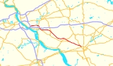
Pennsylvania Route 283 is a 29 miles (46.7 km) long state highway
in the U.S. state
of Pennsylvania
. It connects Harrisburg to Lancaster as a freeway, paralleling the old U.S. Route 230 (now partly Pennsylvania Route 230
). The number was assigned based on the proximity of Interstate 283
, but Interstate 283
and PA 283 are not the same roadway; the two intersect at a cloverleaf interchange
. Because the road is built to Interstate Standards
, it is one of the few non-interstate designated highways in Pennsylvania
with a posted speed limit
of 65 mi/h for a considerable distance.
 PA 283 begins at an intersection with Eisenhower Boulevard (Quadrant Route 3001) near Highspire
that connects to Pennsylvania Route 230
. PA 283 is one of few Pennsylvania Highways to end at a Quadrant Route. From there, PA 283 intersects Interstate 283
at exit 1 and Interstate 76
(Pennsylvania Turnpike
) at exit 247 (Harrisburg East exit) at a cloverleaf interchange
. East of I-283 and I-76, PA 283 is a 29 miles (46.7 km) long freeway. In Lower Swatara Township
, PA 283 has an exit to a freeway road (Quadrant Route 3032) that connects to Harrisburg International Airport
and Pennsylvania Route 441
. This exit has access to Penn State Harrisburg
. East of PA 441, PA 283 has an exit to Union Street and Fulling Mill Road which are detours to PA 441. After crossing the Swatara Creek
and entering Londonderry Township
, PA 283 has an exit to Hummelstown
on Vine Street. In Middletown
, PA 283 passes over I-76/PA Turnpike and Pennsylvania Route 341
. The next exit is an exit that leads to both PA 341 and PA 230
.
 The first exit in Lancaster County
is an exit to Pennsylvania Route 743
. Just east of PA 743, PA 283 passes over Pennsylvania Route 241
. In Mount Joy
, PA 283 has an exit to Rheems and Elizabethtown. In Rapho Township
, PA 283 interchanges with Pennsylvania Route 772
. The next exit is split up into two interchanges that lead to the eastern terminus of PA 230
on the Harrisburg Pike. (East of here, PA 283 has a narrow median strip as it is using old Route 230.) In East Hempfield Township
, PA 283 interchanges with Spooky Nook Road to Salunga. The next exit is a diamond interchange
with the western terminus of Pennsylvania Route 722
. In Manheim Township
, PA 283 interchanges with Pennsylvania Route 741
and Pennsylvania Route 72
. PA 283 terminates (ends) at an interchange with U.S. Route 30
in Lancaster
. The first exit is to US 30 west, then the second exit is to Fruitville Pike, and the final exit is to US 30 east.
State highway
State highway, state road or state route can refer to one of three related concepts, two of them related to a state or provincial government in a country that is divided into states or provinces :#A...
in the U.S. state
U.S. state
A U.S. state is any one of the 50 federated states of the United States of America that share sovereignty with the federal government. Because of this shared sovereignty, an American is a citizen both of the federal entity and of his or her state of domicile. Four states use the official title of...
of Pennsylvania
Pennsylvania
The Commonwealth of Pennsylvania is a U.S. state that is located in the Northeastern and Mid-Atlantic regions of the United States. The state borders Delaware and Maryland to the south, West Virginia to the southwest, Ohio to the west, New York and Ontario, Canada, to the north, and New Jersey to...
. It connects Harrisburg to Lancaster as a freeway, paralleling the old U.S. Route 230 (now partly Pennsylvania Route 230
Pennsylvania Route 230
Pennsylvania Route 230 is a state route in central Pennsylvania. Its western terminus is at an intersection with U.S. Route 22 in Harrisburg. Its eastern terminus is at an interchange with Pennsylvania Route 283 near Salunga.-Route description:...
). The number was assigned based on the proximity of Interstate 283
Interstate 283
Interstate 283 , considered State Route 283 by PennDOT, is an auxiliary route of the Interstate Highway System located just east of Harrisburg, Pennsylvania, United States. It runs from the Harrisburg East interchange of Interstate 76 north to Interstate 83 and U.S...
, but Interstate 283
Interstate 283
Interstate 283 , considered State Route 283 by PennDOT, is an auxiliary route of the Interstate Highway System located just east of Harrisburg, Pennsylvania, United States. It runs from the Harrisburg East interchange of Interstate 76 north to Interstate 83 and U.S...
and PA 283 are not the same roadway; the two intersect at a cloverleaf interchange
Cloverleaf interchange
A cloverleaf interchange is a two-level interchange in which left turns, reverse direction in left-driving regions, are handled by ramp roads...
. Because the road is built to Interstate Standards
Interstate Highway standards
Standards for Interstate Highways in the United States are defined by the American Association of State Highway and Transportation Officials in the publication A Policy on Design Standards - Interstate System...
, it is one of the few non-interstate designated highways in Pennsylvania
Pennsylvania
The Commonwealth of Pennsylvania is a U.S. state that is located in the Northeastern and Mid-Atlantic regions of the United States. The state borders Delaware and Maryland to the south, West Virginia to the southwest, Ohio to the west, New York and Ontario, Canada, to the north, and New Jersey to...
with a posted speed limit
Speed limit
Road speed limits are used in most countries to regulate the speed of road vehicles. Speed limits may define maximum , minimum or no speed limit and are normally indicated using a traffic sign...
of 65 mi/h for a considerable distance.
Dauphin County
Highspire, Pennsylvania
Highspire is a borough in Dauphin County, Pennsylvania, United States. The population was 2,720 at the 2000 census. It is part of the Harrisburg–Carlisle Metropolitan Statistical Area.The American actor Don Keefer was born in Highspire in 1916....
that connects to Pennsylvania Route 230
Pennsylvania Route 230
Pennsylvania Route 230 is a state route in central Pennsylvania. Its western terminus is at an intersection with U.S. Route 22 in Harrisburg. Its eastern terminus is at an interchange with Pennsylvania Route 283 near Salunga.-Route description:...
. PA 283 is one of few Pennsylvania Highways to end at a Quadrant Route. From there, PA 283 intersects Interstate 283
Interstate 283
Interstate 283 , considered State Route 283 by PennDOT, is an auxiliary route of the Interstate Highway System located just east of Harrisburg, Pennsylvania, United States. It runs from the Harrisburg East interchange of Interstate 76 north to Interstate 83 and U.S...
at exit 1 and Interstate 76
Interstate 76 (east)
Interstate 76 is an Interstate Highway in the United States, running 435 miles from an interchange with Interstate 71 west of Akron, Ohio, east to Interstate 295 near Camden, New Jersey....
(Pennsylvania Turnpike
Pennsylvania Turnpike
The Pennsylvania Turnpike is a toll highway system operated by the Pennsylvania Turnpike Commission in the Commonwealth of Pennsylvania, United States. The three sections of the turnpike system total . The main section extends from Ohio to New Jersey and is long...
) at exit 247 (Harrisburg East exit) at a cloverleaf interchange
Cloverleaf interchange
A cloverleaf interchange is a two-level interchange in which left turns, reverse direction in left-driving regions, are handled by ramp roads...
. East of I-283 and I-76, PA 283 is a 29 miles (46.7 km) long freeway. In Lower Swatara Township
Lower Swatara Township, Pennsylvania
Lower Swatara Township is a township in Dauphin County, Pennsylvania, United States. The population was 8,149 at the 2000 census. Harrisburg International Airport and Penn State Harrisburg are located within the township.-History:...
, PA 283 has an exit to a freeway road (Quadrant Route 3032) that connects to Harrisburg International Airport
Harrisburg International Airport
-Statistics:-Air cargo:Harrisburg International Airport is well positioned with freight-forwarding capabilities. The airport is located adjacent to I-76 , I-83, and I-81, allowing for fast air-to-ground transfer of goods and commodities...
and Pennsylvania Route 441
Pennsylvania Route 441
Pennsylvania Route 441 is a long state route in central Pennsylvania and mostly parallels the Susquehanna River. The southern terminus is at Pennsylvania Route 999 in the Manor Township hamlet of Washington Boro...
. This exit has access to Penn State Harrisburg
Penn State Harrisburg
Penn State Harrisburg, also called The Capital College, is an undergraduate college and graduate school of the Pennsylvania State University. The main campus of Penn State Harrisburg is located in Lower Swatara Township, 9 miles south of Harrisburg...
. East of PA 441, PA 283 has an exit to Union Street and Fulling Mill Road which are detours to PA 441. After crossing the Swatara Creek
Swatara Creek
Swatara Creek is a tributary of the Susquehanna River in east central Pennsylvania in the United States. "Swatara" is an Indian word meaning "Where we feed on eels."...
and entering Londonderry Township
Londonderry Township, Dauphin County, Pennsylvania
Londonderry Township is a township in Dauphin County, Pennsylvania, United States. The population was 5,224 at the 2000 census.The township includes the site of the 1979 Three Mile Island Nuclear Generating Station accident, which was the largest accident of its kind in the American nuclear power...
, PA 283 has an exit to Hummelstown
Hummelstown, Pennsylvania
Hummelstown is a borough in Dauphin County, Pennsylvania, United States. The population was 4,360 as of the 2000 census. It is part of the Harrisburg–Carlisle Metropolitan Statistical Area....
on Vine Street. In Middletown
Middletown, Dauphin County, Pennsylvania
Middletown is a borough in Dauphin County, Pennsylvania, on the Susquehanna River, nine miles southeast of Harrisburg. It is part of the Harrisburg–Carlisle Metropolitan Statistical Area.-History:...
, PA 283 passes over I-76/PA Turnpike and Pennsylvania Route 341
Pennsylvania Route 341
Pennsylvania Route 341 is a state highway in the U.S. state of Pennsylvania. The route runs from Pennsylvania Route 230 in Londonderry Township in Dauphin County east to Pennsylvania Route 241 in South Londonderry Township in Lebanon County.-Route description:...
. The next exit is an exit that leads to both PA 341 and PA 230
Pennsylvania Route 230
Pennsylvania Route 230 is a state route in central Pennsylvania. Its western terminus is at an intersection with U.S. Route 22 in Harrisburg. Its eastern terminus is at an interchange with Pennsylvania Route 283 near Salunga.-Route description:...
.
Lancaster County
Lancaster County, Pennsylvania
Lancaster County, known as the Garden Spot of America or Pennsylvania Dutch Country, is a county located in the southeastern part of the Commonwealth of Pennsylvania, in the United States. As of 2010 the population was 519,445. Lancaster County forms the Lancaster Metropolitan Statistical Area, the...
is an exit to Pennsylvania Route 743
Pennsylvania Route 743
Pennsylvania Route 743, PA 743, is a north–south state route located in central Pennsylvania. The northern terminus is at Pennsylvania Route 443 one mile west of the East Hanover Township hamlet of Grantville. The southern terminus is at Pennsylvania Route 441 in Marietta...
. Just east of PA 743, PA 283 passes over Pennsylvania Route 241
Pennsylvania Route 241
Pennsylvania Route 241 is a 23 mile long state highway in the U.S. state of Pennsylvania. The route runs from Pennsylvania Route 441 in Conoy Township, Lancaster County northeast to Pennsylvania Route 72 in the city of Lebanon in Lebanon County....
. In Mount Joy
Mount Joy, Pennsylvania
Mount Joy is a borough in Lancaster County, Pennsylvania, United States. The population was 6,765 at the 2000 census.-Name and origin:Mount Joy is often named in lists of "delightfully-named towns" in Pennsylvania Dutchland, along with Intercourse, Blue Ball, PenisPallooza, Amish Land, Dick-in-Hand...
, PA 283 has an exit to Rheems and Elizabethtown. In Rapho Township
Rapho Township, Pennsylvania
Rapho Township is a township in northwestern Lancaster County, Pennsylvania, United States. The population was 8,578 at the 2000 census.-Geography:...
, PA 283 interchanges with Pennsylvania Route 772
Pennsylvania Route 772
Pennsylvania Route 772 or is an east–west long state highway located in Lancaster County, Pennsylvania. It is a scenic alternative to U.S. Route 30 as it roughly parallels the main highway to the north. The highway is mostly named Newport Road...
. The next exit is split up into two interchanges that lead to the eastern terminus of PA 230
Pennsylvania Route 230
Pennsylvania Route 230 is a state route in central Pennsylvania. Its western terminus is at an intersection with U.S. Route 22 in Harrisburg. Its eastern terminus is at an interchange with Pennsylvania Route 283 near Salunga.-Route description:...
on the Harrisburg Pike. (East of here, PA 283 has a narrow median strip as it is using old Route 230.) In East Hempfield Township
East Hempfield Township, Pennsylvania
East Hempfield Township is a township in west-central Lancaster County, Pennsylvania, United States. At the 2000 census the population was 21,399....
, PA 283 interchanges with Spooky Nook Road to Salunga. The next exit is a diamond interchange
Diamond interchange
A diamond interchange is a common type of road junction, used where a freeway crosses a minor road. The freeway itself is grade-separated from the minor road, one crossing the other over a bridge...
with the western terminus of Pennsylvania Route 722
Pennsylvania Route 722
Pennsylvania Route 722 is an long, east–west state highway located in central Lancaster County, Pennsylvania. The eastern terminus is at PA 272 in Oregon...
. In Manheim Township
Manheim Township, Lancaster County, Pennsylvania
Manheim Township is a township in Lancaster County, Pennsylvania established in 1729, which southernmost border meets the city limits of Lancaster. The population as of the 2000 census was 33,697.-Government:...
, PA 283 interchanges with Pennsylvania Route 741
Pennsylvania Route 741
Pennsylvania Route 741 is a long state highway that runs through western and southern Lancaster County in the U.S. state of Pennsylvania. The eastern terminus is at Pennsylvania Route 41 in Gap...
and Pennsylvania Route 72
Pennsylvania Route 72
Pennsylvania Route 72 is a long north–south state route located in southeast Pennsylvania. The southern terminus of the route is at U.S. Route 222 and Pennsylvania Route 272 in downtown Lancaster. The northern terminus is at Pennsylvania Route 443 north of Lickdale in Swatara Township.It...
. PA 283 terminates (ends) at an interchange with U.S. Route 30
U.S. Route 30
U.S. Route 30 is an east–west main route of the system of United States Numbered Highways, with the highway traveling across the northern tier of the country. It is the third longest U.S. route, after U.S. Route 20 and U.S. Route 6. The western end of the highway is at Astoria, Oregon; the...
in Lancaster
Lancaster, Pennsylvania
Lancaster is a city in the south-central part of the Commonwealth of Pennsylvania. It is the county seat of Lancaster County and one of the older inland cities in the United States, . With a population of 59,322, it ranks eighth in population among Pennsylvania's cities...
. The first exit is to US 30 west, then the second exit is to Fruitville Pike, and the final exit is to US 30 east.
Exit list
| County | Location | Mile | Destinations | Notes |
|---|---|---|---|---|
| Dauphin | Lower Swatara Township | 0.0 | Westbound exit and eastbound entrance. | |
| 0.1 | Harrisburg East exit of PA Turnpike | |||
| 0.3 | ||||
| 1.8 | Penn State Harrisburg Penn State Harrisburg Penn State Harrisburg, also called The Capital College, is an undergraduate college and graduate school of the Pennsylvania State University. The main campus of Penn State Harrisburg is located in Lower Swatara Township, 9 miles south of Harrisburg... |
|||
| 2.9 | ||||
| Londonderry Township Londonderry Township, Dauphin County, Pennsylvania Londonderry Township is a township in Dauphin County, Pennsylvania, United States. The population was 5,224 at the 2000 census.The township includes the site of the 1979 Three Mile Island Nuclear Generating Station accident, which was the largest accident of its kind in the American nuclear power... |
3.9 | Middletown Middletown, Dauphin County, Pennsylvania Middletown is a borough in Dauphin County, Pennsylvania, on the Susquehanna River, nine miles southeast of Harrisburg. It is part of the Harrisburg–Carlisle Metropolitan Statistical Area.-History:... , Hummelstown Hummelstown, Pennsylvania Hummelstown is a borough in Dauphin County, Pennsylvania, United States. The population was 4,360 as of the 2000 census. It is part of the Harrisburg–Carlisle Metropolitan Statistical Area.... |
||
| 6.8 | ||||
| Lancaster | Mount Joy Township Mount Joy Township, Lancaster County, Pennsylvania Mount Joy Township is a township in northwestern Lancaster County, Pennsylvania, United States. The population was 7,944 at the 2000 census.-Geography:... |
11.6 | ||
| 15.0 | Rheems Rheems, Pennsylvania Rheems is a census-designated place in Lancaster County, Pennsylvania, United States situated between the boroughs of Elizabethtown and Mount Joy... , Elizabethtown Elizabethtown, Pennsylvania Elizabethtown is a borough in Lancaster County, Pennsylvania, southeast of Harrisburg. Small factories existed at the turn of the century when the population in 1900 was 1,861. There was a slight increase in the next decade, with 1,970 people living in Elizabethtown in 1910. As of the 2000 census,... |
|||
| Rapho Township | 20.0 | |||
| 21.2 | Esbenshade Road | Eastbound Exit, Westbound Entrance | ||
| 21.8 | Eastern terminus of PA 230, Westbound exit, Eastbound entrance. | |||
| East Hempfield Township | 22.5 | Spooky Nook Road - Salunga | ||
| 25.4 | Western terminus of PA 722. Continues westbound as State Rd. | |||
| 27.0 | ||||
| Manheim Township Manheim Township, Lancaster County, Pennsylvania Manheim Township is a township in Lancaster County, Pennsylvania established in 1729, which southernmost border meets the city limits of Lancaster. The population as of the 2000 census was 33,697.-Government:... |
27.8 | |||
| Lancaster | 28.4 | Eastbound exit and westbound entrance. | ||
| 28.7 | Fruitville Pike | Eastbound exit and westbound entrance. | ||
| 29.0 | Eastbound exit and westbound entrance. |