
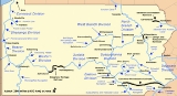
Susquehanna and Tidewater Canal
Encyclopedia
The Susquehanna and Tidewater Canal between Wrightsville, Pennsylvania
, and Havre de Grace, Maryland
, at the head of Chesapeake Bay, provided an interstate shipping alternative to 19th-century ark
s, rafts, and boats plying the difficult waters of the lower Susquehanna River
. Built between 1836 and 1840, it ran 43 miles (69 km) along the west bank of the river and rendered obsolete an older, shorter canal along the east bank. Of its total length, 30 miles (48 km) were in Pennsylvania and 13 miles (21 km) in Maryland. Though rivalry between Philadelphia, Pennsylvania
, and Baltimore, Maryland, delayed its construction, the finished canal brought increased shipments of coal and other raw materials to both cities from Pennsylvania's interior. Competition from railroads was a large factor in the canal's decline after 1855. Canal remnants, including a lock
keeper's house, have been preserved in Maryland, and a lock has been preserved in Pennsylvania.
at Columbia, Pennsylvania
, across the river from Wrightsville. Residents of the rival port city of Philadelphia, fearing loss of trade to Baltimore, argued against the proposal. In 1829, completion of the Chesapeake and Delaware Canal
across an isthmus south of Philadelphia, resolved the impasse by shortening the water link between Havre de Grace and Philadelphia to 74 miles (119 km). Since this was only 20 miles (32 km) further by water than from Havre de Grace to Baltimore, the Susquehanna and Tidewater Canal stood to benefit both cities. In 1835, the Susquehanna Canal Company of Pennsylvania joined the Tidewater Canal Company of Maryland in privately funding and building the canal. Construction began in 1836 and was finished in 1840.
hastened the decline. In 1872, the company sold its assets to the Philadelphia and Reading Railroad, which used the canal to haul coal to Baltimore until 1894, during the Reading's first receivership
(caused by the Panic of 1893
). The Pennsylvania Railroad
opened the Columbia and Port Deposit Railroad
across the river in 1877.
s overcoming 231 feet (70 m) of elevation. At Wrightsville and the Columbia
canal basin
, it connected with the Pennsylvania Canal
's Eastern Division, part of the Main Line of Public Works. Cargo included coal, lumber, grain, and iron, much of it bound for Baltimore or Philadelphia. Boats passed through a weigh lock at York Furnace, where tolls were paid. Teams of mules walked on towpath
s beside the canal and pulled the boats. At the upper terminus, across the river from Columbia, a wooden bridge with a two-tier tow path allowed mules going in opposite directions to cross the Susquehanna River simultaneously without colliding. From the canal outlet at Havre de Grace, tugs
pulled the boats to Baltimore or other destinations. Mules on the Baltimore boats waited in Havre de Grace for the return journey, while boats bound for Philadelphia took their mules with them to use on the next towpath canal.
, was approved by Pennsylvania until after the opening in 1829 of the Chesapeake and Delaware Canal
. It cut across the northern isthmus of the Delmarva Peninsula
and made a lower Susquehanna canal more appealing to Philadelphia. A combination of high costs, faulty construction, and low revenues led the Proprietors to sell the Susquehanna Canal at a loss in 1817, and it was abandoned entirely in 1840 when the Susquehanna and Tidewater Canal opened on the opposite side of the river. The Susquehanna Canal was also known as the Port Deposit Canal or the Conowingo Canal, not to be confused with the Conewago Canal
upstream near York Haven.
, 3 miles (4.8 km) miles northwest of Havre de Grace as part of the Southern Terminal, Susquehanna and Tidewater Canal
historic district
listed on the National Register of Historic Places
. The Susquehanna Museum in Havre de Grace has restored the lock house and other infrastructure at the southern terminus of the canal. On the Pennsylvania side, Lock #12 has been preserved by the Pennsylvania Power and Light Company along Pennsylvania Route 372 at the south end of the Norman Wood Bridge
across the Susquehanna River.
. Its rights as a Maryland corporation dating to 1783, allowed the construction of the Conowingo Dam
.
Wrightsville, Pennsylvania
Wrightsville is a borough in York County, Pennsylvania, United States. The population was 2,310 at the 2010 census. Wrightsville borough has a police department, historic society, and a volunteer fire company.- History :According to a plaque at Samuel S...
, and Havre de Grace, Maryland
Havre de Grace, Maryland
Havre de Grace is a city in Harford County, Maryland, United States. Located at the mouth of the Susquehanna River and the head of the Chesapeake Bay, Havre de Grace is named after the port city of Le Havre, France, which was first named Le Havre de Grâce, meaning in French "Harbor of Grace." As...
, at the head of Chesapeake Bay, provided an interstate shipping alternative to 19th-century ark
Ark (river boat)
An ark was a temporary boat used for river transport in eastern North America before canals and railroads made them obsolete.Arks were built primarily to carry cargo downriver on the spring freshet to carry lumber or logs and agricultural produce to a port city downriver.Upon arrival, the cargo was...
s, rafts, and boats plying the difficult waters of the lower Susquehanna River
Susquehanna River
The Susquehanna River is a river located in the northeastern United States. At long, it is the longest river on the American east coast that drains into the Atlantic Ocean, and with its watershed it is the 16th largest river in the United States, and the longest river in the continental United...
. Built between 1836 and 1840, it ran 43 miles (69 km) along the west bank of the river and rendered obsolete an older, shorter canal along the east bank. Of its total length, 30 miles (48 km) were in Pennsylvania and 13 miles (21 km) in Maryland. Though rivalry between Philadelphia, Pennsylvania
Philadelphia, Pennsylvania
Philadelphia is the largest city in the Commonwealth of Pennsylvania and the county seat of Philadelphia County, with which it is coterminous. The city is located in the Northeastern United States along the Delaware and Schuylkill rivers. It is the fifth-most-populous city in the United States,...
, and Baltimore, Maryland, delayed its construction, the finished canal brought increased shipments of coal and other raw materials to both cities from Pennsylvania's interior. Competition from railroads was a large factor in the canal's decline after 1855. Canal remnants, including a lock
Lock (water transport)
A lock is a device for raising and lowering boats between stretches of water of different levels on river and canal waterways. The distinguishing feature of a lock is a fixed chamber in which the water level can be varied; whereas in a caisson lock, a boat lift, or on a canal inclined plane, it is...
keeper's house, have been preserved in Maryland, and a lock has been preserved in Pennsylvania.
Competition
In the 1820s, seeking raw materials from and trade with Pennsylvania's interior counties, residents of the large port city of Baltimore favored building a canal along the lower Susquehanna linking Chesapeake Bay to Pennsylvania's Main Line of Public WorksMain Line of Public Works
The Main Line of Public Works was a railroad and canal system built by the Commonwealth of Pennsylvania in the 19th century. It ran from Philadelphia west through Harrisburg and across the state to Pittsburgh and connected with other divisions of the Pennsylvania Canal...
at Columbia, Pennsylvania
Columbia, Pennsylvania
Columbia, once colonial Wright's Ferry, is a borough in Lancaster County, Pennsylvania, 28 miles southeast of Harrisburg on the left bank Susquehanna River across from Wrightsville and York County. Originally, the area may have been called Conejohela Flats, for the many islands and islets in the...
, across the river from Wrightsville. Residents of the rival port city of Philadelphia, fearing loss of trade to Baltimore, argued against the proposal. In 1829, completion of the Chesapeake and Delaware Canal
Chesapeake and Delaware Canal
The Chesapeake and Delaware Canal is a 14-mile long, 450-foot wide and 40-foot deep ship canal that cuts across the states of Maryland and Delaware, in the United States. It connects the waters of the Delaware River with those of the Chesapeake Bay and the Port of Baltimore...
across an isthmus south of Philadelphia, resolved the impasse by shortening the water link between Havre de Grace and Philadelphia to 74 miles (119 km). Since this was only 20 miles (32 km) further by water than from Havre de Grace to Baltimore, the Susquehanna and Tidewater Canal stood to benefit both cities. In 1835, the Susquehanna Canal Company of Pennsylvania joined the Tidewater Canal Company of Maryland in privately funding and building the canal. Construction began in 1836 and was finished in 1840.
Debt
Despite toll collections rising from $42,000 in its first year to about four times that amount by 1850, the canal company faced money problems. Construction costs had totaled $3.5 million; with only $1.25 million in start-up capital, the company had borrowed heavily, and it struggled to pay its debts. After 1855, toll revenue fell; flood damage, railroad competition, and the disruptions of the Civil WarAmerican Civil War
The American Civil War was a civil war fought in the United States of America. In response to the election of Abraham Lincoln as President of the United States, 11 southern slave states declared their secession from the United States and formed the Confederate States of America ; the other 25...
hastened the decline. In 1872, the company sold its assets to the Philadelphia and Reading Railroad, which used the canal to haul coal to Baltimore until 1894, during the Reading's first receivership
Receivership
In law, receivership is the situation in which an institution or enterprise is being held by a receiver, a person "placed in the custodial responsibility for the property of others, including tangible and intangible assets and rights." The receivership remedy is an equitable remedy that emerged in...
(caused by the Panic of 1893
Panic of 1893
The Panic of 1893 was a serious economic depression in the United States that began in 1893. Similar to the Panic of 1873, this panic was marked by the collapse of railroad overbuilding and shaky railroad financing which set off a series of bank failures...
). The Pennsylvania Railroad
Pennsylvania Railroad
The Pennsylvania Railroad was an American Class I railroad, founded in 1846. Commonly referred to as the "Pennsy", the PRR was headquartered in Philadelphia, Pennsylvania....
opened the Columbia and Port Deposit Railroad
Columbia and Port Deposit Railroad
The Columbia and Port Deposit Railroad was a railroad that operated in Pennsylvania and Maryland in the 19th and early 20th centuries. It operated a main line between Columbia, Pennsylvania and Port Deposit, Maryland, generally along the eastern shore of the Susquehanna River. It later acquired...
across the river in 1877.
Infrastructure, cargo
The canal had 29 lockLock (water transport)
A lock is a device for raising and lowering boats between stretches of water of different levels on river and canal waterways. The distinguishing feature of a lock is a fixed chamber in which the water level can be varied; whereas in a caisson lock, a boat lift, or on a canal inclined plane, it is...
s overcoming 231 feet (70 m) of elevation. At Wrightsville and the Columbia
Columbia, Pennsylvania
Columbia, once colonial Wright's Ferry, is a borough in Lancaster County, Pennsylvania, 28 miles southeast of Harrisburg on the left bank Susquehanna River across from Wrightsville and York County. Originally, the area may have been called Conejohela Flats, for the many islands and islets in the...
canal basin
Wrightsville (Columbia) Dam (1840)
The Wrightsville Dam was a 19th century dam on the lower Susquehanna River between Wrightsville and Columbia, Pennsylvania.The low-head dam was constructed in 1840 to impound the waters of the Susquehanna to provide a slackwater pool to allow the safe passage of canal boats from the Pennsylvania...
, it connected with the Pennsylvania Canal
Pennsylvania Canal
Pennsylvania Canal refers generally to a complex system of canals, dams, locks, tow paths, aqueducts, and other infrastructure including, in some cases, railroads in Pennsylvania...
's Eastern Division, part of the Main Line of Public Works. Cargo included coal, lumber, grain, and iron, much of it bound for Baltimore or Philadelphia. Boats passed through a weigh lock at York Furnace, where tolls were paid. Teams of mules walked on towpath
Towpath
A towpath is a road or trail on the bank of a river, canal, or other inland waterway. The purpose of a towpath is to allow a land vehicle, beasts of burden, or a team of human pullers to tow a boat, often a barge...
s beside the canal and pulled the boats. At the upper terminus, across the river from Columbia, a wooden bridge with a two-tier tow path allowed mules going in opposite directions to cross the Susquehanna River simultaneously without colliding. From the canal outlet at Havre de Grace, tugs
Tugboat
A tugboat is a boat that maneuvers vessels by pushing or towing them. Tugs move vessels that either should not move themselves, such as ships in a crowded harbor or a narrow canal,or those that cannot move by themselves, such as barges, disabled ships, or oil platforms. Tugboats are powerful for...
pulled the boats to Baltimore or other destinations. Mules on the Baltimore boats waited in Havre de Grace for the return journey, while boats bound for Philadelphia took their mules with them to use on the next towpath canal.
Earlier canal
Long before the opening of the Susquehanna and Tidewater Canal, the Maryland legislature of 1783, hoping to open a reliable trade route along the lower Susquehanna River, had granted a charter to a company of 40 men, mostly from Baltimore, to build a canal called the Susquehanna Canal. The Proprietors of the Susquehanna Canal, as the company was called, succeeded by 1802 in completing a canal of 9 miles (14 km) along the east bank of the river from Chesapeake Bay to the Pennsylvania state line. The Proprietors hoped the Pennsylvania legislature would allow an extension on the other side of the state line; however, no canal below Columbia, PennsylvaniaColumbia, Pennsylvania
Columbia, once colonial Wright's Ferry, is a borough in Lancaster County, Pennsylvania, 28 miles southeast of Harrisburg on the left bank Susquehanna River across from Wrightsville and York County. Originally, the area may have been called Conejohela Flats, for the many islands and islets in the...
, was approved by Pennsylvania until after the opening in 1829 of the Chesapeake and Delaware Canal
Chesapeake and Delaware Canal
The Chesapeake and Delaware Canal is a 14-mile long, 450-foot wide and 40-foot deep ship canal that cuts across the states of Maryland and Delaware, in the United States. It connects the waters of the Delaware River with those of the Chesapeake Bay and the Port of Baltimore...
. It cut across the northern isthmus of the Delmarva Peninsula
Delmarva Peninsula
The Delmarva Peninsula is a large peninsula on the East Coast of the United States, occupied by most of Delaware and portions of Maryland and Virginia...
and made a lower Susquehanna canal more appealing to Philadelphia. A combination of high costs, faulty construction, and low revenues led the Proprietors to sell the Susquehanna Canal at a loss in 1817, and it was abandoned entirely in 1840 when the Susquehanna and Tidewater Canal opened on the opposite side of the river. The Susquehanna Canal was also known as the Port Deposit Canal or the Conowingo Canal, not to be confused with the Conewago Canal
Conewago Canal
The Conewago Canal, on the west bank of the Susquehanna River below York Haven, Pennsylvania, south of Harrisburg in York County, enabled late 18th and early 19th century rivercraft to safely bypass rapids at Conewago Falls. Work on the canal of less than began in 1793 and was completed in 1797...
upstream near York Haven.
Remnants
Remnants of the canal can be seen at Susquehanna State Park in Harford County, MarylandHarford County, Maryland
Harford County is a county in the U.S. state of Maryland. In 2010, its population was 244,826. Its county seat is Bel Air. Harford County forms part of the Baltimore-Washington Metropolitan Area.-History:...
, 3 miles (4.8 km) miles northwest of Havre de Grace as part of the Southern Terminal, Susquehanna and Tidewater Canal
Southern Terminal, Susquehanna and Tidewater Canal
The Southern Terminal, Susquehanna and Tidewater Canal is a national historic district at Havre de Grace, Harford County, Maryland, United States. Located along the western bank of the Susquehanna River near its mouth at the Chesapeake Bay, it includes the Lock Master's House, the canal's outlet...
historic district
Historic district (United States)
In the United States, a historic district is a group of buildings, properties, or sites that have been designated by one of several entities on different levels as historically or architecturally significant. Buildings, structures, objects and sites within a historic district are normally divided...
listed on the National Register of Historic Places
National Register of Historic Places
The National Register of Historic Places is the United States government's official list of districts, sites, buildings, structures, and objects deemed worthy of preservation...
. The Susquehanna Museum in Havre de Grace has restored the lock house and other infrastructure at the southern terminus of the canal. On the Pennsylvania side, Lock #12 has been preserved by the Pennsylvania Power and Light Company along Pennsylvania Route 372 at the south end of the Norman Wood Bridge
Norman Wood Bridge
The Norman Wood Bridge carries Pennsylvania Route 372 across the Susquehanna River between York County, Pennsylvania and Lancaster County, Pennsylvania....
across the Susquehanna River.
Corporate successor
As a corporate entity, the corporation known as The Proprietors of the Susquehanna Canal still exists, having been purchased by the Philadelphia Electric Company, and now owned by its successor, ExelonExelon
Exelon Corporation is an electricity generating and distributing company headquartered in the Chase Tower in the Chicago Loop area of Chicago. It was created in October, 2000 by the merger of PECO Energy Company and Unicom, of Philadelphia and Chicago respectively. Unicom owned Commonwealth Edison...
. Its rights as a Maryland corporation dating to 1783, allowed the construction of the Conowingo Dam
Conowingo Dam
The Conowingo Dam is a large hydroelectric dam in the Lower Susquehanna River. The dam, one of the largest non-federal hydroelectric dams in the US, is classified as a medium height, masonry gravity type dam...
.
Points of interest
| Feature | Coordinates | Description |
|---|---|---|
| Columbia Columbia, Pennsylvania Columbia, once colonial Wright's Ferry, is a borough in Lancaster County, Pennsylvania, 28 miles southeast of Harrisburg on the left bank Susquehanna River across from Wrightsville and York County. Originally, the area may have been called Conejohela Flats, for the many islands and islets in the... |
40°02′01"N 76°30′16"W | Borough Borough A borough is an administrative division in various countries. In principle, the term borough designates a self-governing township although, in practice, official use of the term varies widely.... at the western terminus of the Philadelphia and Columbia Railroad and the southern terminus of the Eastern Division Canal |
| Peach Bottom Peach Bottom, Pennsylvania Peach Bottom, Pennsylvania is an unincorporated village in Fulton Township, Lancaster County, in the state of Pennsylvania in the United States. It lies on the east bank of the Susquehanna River, at .... |
39°45′03"N 76°13′33"W | Village near the mid-point of the canal |
| Havre de Grace Havre de Grace, Maryland Havre de Grace is a city in Harford County, Maryland, United States. Located at the mouth of the Susquehanna River and the head of the Chesapeake Bay, Havre de Grace is named after the port city of Le Havre, France, which was first named Le Havre de Grâce, meaning in French "Harbor of Grace." As... |
39°32′57"N 76°05′30"W | City at the southern terminus |