
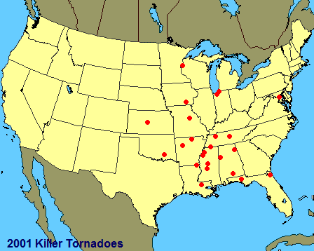
Tornadoes of 2001
Encyclopedia
This page documents the tornado
es and tornado outbreak
s of 2001, primarily in the United States
. Most tornadoes form in the U.S., although some events may take place internationally.
 January 19
Four minor tornadoes were caused by a bow echo
in Georgia and Alabama
. Four people were injured by an F0 near Montgomery, Alabama
. Eight more were injured when another F0 struck a shopping center near Hartsfield International Airport. Two other tornadoes in Georgia (an F0 and an F1) caused negligible damage and no injuries.
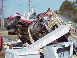
An F2 tornado touched down near Goodman, Mississippi
damaging cabins, downing trees, and tossing vehicles. One woman was crushed to death by her car after abandoning it for a ditch—considered better shelter from a tornado than a vehicle. Four F0 tornadoes also occurred, with no injuries.
February 24-25
 A moderate tornado outbreak affected several southern US states. A line of tornado-producing supercell
s formed out in front of a squall line
which produced damaging winds. Over ten hours, twenty-five tornadoes killed 7, injured 90, and caused $35 million in damage, primarily in Arkansas
and Mississippi
.
The main storm was an F3 which touched down north of Bruce, Mississippi
late on the night of the 24th. Almost 400 structures were damaged or destroyed in the town of Pontotoc
, where 6 were killed and 43 injured. The tornado would track more than 50 miles (80.5 km), injuring another 30 people in the town of Baldwyn
, before lifting near Wheeler.
Aside from the killer F3, there were several other significant tornadoes that day. In Fulton County, Arkansas, an F2 flung a mobile home 60 feet (18 m), killing a two-year-old boy and seriously injuring three other occupants. All told, there were three F3s, seven F2s, seven F1s and four F0s on the 24th. After midnight on the 25th, four F0s tracked through central Tennessee
, causing negligible damage.
A small progressive tornado outbreak stretched from Texas
to Georgia. At 3:30AM, an F1 tornado touched down outside of Tatum, Texas
, moving into the town and causing damage to several structures. Two F0s were reported later in the morning in and around Kentwood, Louisiana. Nine more minor tornadoes struck southern Mississippi that morning, including F1s which injured 7 and 5 in Lamar County
and Forrest County
, respectively. In the afternoon, an F1 tornado destroyed several mobile homes in Red Level, Alabama
, killing two people and injuring another. Another F1 also destroyed mobile homes near Boykin, Georgia
later in the afternoon, injuring 2. After midnight, three tornadoes touched down in extreme northern Florida
, including an F2 in Hamilton County
and an F1 which injured 5 and caused $5 million in damage to Daytona Beach
.
March 15
A small outbreak of 7 tornadoes struck northern Florida
and southern Georgia
between 4:30 and 8:30AM. An F2 struck a residential area near Wausau, Florida
at 4:30AM, killing one person and injuring 21. Another two F2s hit further north near Round Lake
and Kinard
, causing minimal damage. Yet another 2 F2s injured 13 in Decatur
and Grady Counties
in Georgia.
March 29
A small outbreak struck northern Florida on the morning of the 29th. Two F2s and four F0s injured one person and caused a few million dollars in damage.
An F2 injured 2 in the southwestern corner of Kansas
.
April 8
An F1 injured one person as it destroyed a trailer in Mount Etna, Iowa. The main impact that day was a major hail
storm across much of Iowa
.
April 9
A small F2 touched down near Lowellville, Ohio
, two F0s struck Pennsylvania, and one F0 occurred in north-central Illinois. No significant damage or injuries were reported with any of these tornadoes.
April 10-11
An extended tornado outbreak consisting of 97 tornadoes struck the central Great Plains
. The outbreak killed 4 and injured 18, and occurred in three stages.
It began when a strong area of storms moved across eastern Kansas
and adjacent Missouri
on the afternoon of the 10th. One supercell
passed over northern St. Louis
producing ten tornadoes, one of which (an F1) destroyed a mobile home, killing one and injuring two. Tornadoes occurred as far east as southwestern Illinois
, but the supercell is more memorable for exceptionally widespread large hail
. With some hailstones up to baseball size, the swath is the largest continuous in areal coverage and longest in length and duration of very large hail known. Because of the extensive area and heavily populated areas impacted, it is the costliest hailstorm in U.S. history, with $2 billion of insured losses.
The next stage of the outbreak was a swarm of tornadoes which formed on the night of the 10th into the pre-dawn hours of the 11th in Texas
, Oklahoma
, Kansas
and Nebraska
. One person was killed and eleven were injured in this stage, mostly by F2 tornadoes.
After a short break, a third bunch of tornadoes were spawned in and close to the state of Iowa
in the late morning through the afternoon. Mostly weaker tornadoes, there were a few significant tornadoes. One, an F2, destroyed a lodge in the town of Agency
, killing two people and injuring three. All told, more than $23 million in damage was attributed to the entire outbreak.
April 14-15
A few tornadoes touched down in Kansas and Missouri late on the 14th into the early morning of the 15th. Just after midnight, an F1 touched down near Redings Mill, Missouri
, damaging several homes and flipping over a trailer, injuring one person.
April 17
Two minor tornadoes touched down in far eastern North Carolina
.
April 21
An outbreak of eleven tornadoes hit central Kansas. While mainly minor, one was an F4 monster, which reportedly struck without warning. Touching down just outside of Hoisington
, it tore a two-block-wide path through the north and west sides of town, completely destroying almost 200 homes and businesses and damaging another 230. The roof of the local hospital was partially torn off. The tornado caused $43 million in damage. Twenty-eight people were injured, and one man was killed by a flying vehicle.
Other tornadoes in the outbreak included an F2 which heavily damaged two farms, and 10 scattered F0s.
Additionally, a rare tornado struck the three state junction area of California
, Arizona
, and Nevada
, crossing the Colorado River
and causing minimal damage.
April 22
Two minor tornadoes touched down in Nebraska. One, an F1, injured a man outside of Blair
.
April 23
Two minor tornadoes again touched down, this time in Iowa. One, an F1, injured three people and damaged dozens of homes in Independence
.
April 30
Three F0 tornadoes produced little or no damage in Iowa.
Ten tornadoes touched down in Minnesota
and Wisconsin
. One, an F2, damaged 100 homes in Glenville, Minnesota
, resulting in $20 million dollars in damage.
May 4
Several weak tornadoes struck northern Texas and central Oklahoma, injuring 4 people. Another mini-outbreak of seven F0 tornadoes touched down in extreme southeastern Nebraska and northwestern Missouri, causing minimal damage and no injuries.
May 9
A small tornado outbreak passed mostly over open fields in Minnesota. One tornado did cause significant damage—one man was injured, and at least 30 structures were damaged or destroyed resulting in $20 million of damage.
May 10
A number of tornadoes, some significant, touched down across central Iowa. Although more than $300,000 in damage was done, there were no injuries.
May 15
A small local outbreak of 8 F0 tornadoes hit northwestern Minnesota, causing minimal damage and no injuries.
May 20
A moderate outbreak of tornadoes stretched across much of Kansas, Oklahoma, and Arkansas. Mostly minor, there was one significant F2 tornado near Dustin, Oklahoma
.
May 21
Another moderate outbreak occurred, mainly on the Lower Peninsula of Michigan
. A few also occurred in eastern Ohio
, and one in West Virginia
. An F2 touched down in Hartland, Michigan, and caused significant damage to the town, mostly to hundreds of damaged and totalled vehicles. Three people were injured by this tornado. Three others were injured in three separate F1 tornadoes, in Elwell, Michigan, Shepherd, Michigan
, and Canton, Ohio
. The outbreak caused more than $7 million in damage.
May 27
A small group of touchdowns occurred over western Kansas. Additionally, four tornadoes, one significant, struck the Mid-Atlantic
states, including an F2 which caused $1 million in damage north of Manalapan, New Jersey.
May 28
A stationary supercell dropped large amounts of rain and hail near Ellicott, Colorado
, as well as four brief tornadoes.
May 29
A moderate tornado outbreak hit the southwestern Great Plains
, mainly in the form of F0 tornadoes in Colorado
, Kansas
, and the Texas Panhandle
. One supercell produced six weak landspout
s and a monster F3 tornado near Lamar, Colorado
. Another F3 destroyed a home and an office building near Panhandle, Texas
. The only casualty from this outbreak was from a large F1 tornado which blew over a semi-truck outside of Quanah, Texas
, badly injuring the driver.
In Poland
one F2 tornado touched down in Podhale
region, and damaged 144 buildings in Morawczyna
and Bielanka, Nowy Targ County
.
May 31
Four tornadoes touched down in Tennessee
and extreme southern Kentucky
. One F2 destroyed several structures, killing one person and injuring two people in Auburntown, Tennessee
. One of the injuries was to a pregnant woman, who also lost her baby.
An outbreak of 18 weak tornadoes struck the state of Iowa. Additionally, an F1 tornado injured three people in Menola, North Carolina.
June 2
An F2 tornado hit London, Kentucky
, causing major damage to shopping centers, vehicles, and mobile homes, injuring ten people.
June 3
A rare Puerto Rico
tornado touched down in Añasco
. No injuries were reported, but several roofs were detached.
Additionally, a small outbreak of six tornadoes struck open country in south-central Kansas
, causing very minor damage and no injuries.
June 5
Another minor outbreak, mainly consisting of landspout
s, occurred over northwestern Texas
and south-central Kansas
. Minor damage to farm equipment was the only loss from the 17 confirmed tornadoes.
 June 7
An F1 tornado blew a tree down onto a truck in Zachary, Louisiana
, killing the driver.
June 9
A slew of minor tornadoes (15 F0s and an F1) caused little damage and minor injuries in the northern Great Plains
.
June 11
A minor outbreak produced 19 tornadoes in Minnesota
and Wisconsin
. The most notable of these was a large F2 tornado which struck Benson, Minnesota
, injuring seven people (one critically) and causing $10 million in damage.
In an unrelated storm system, a man was killed in his living room by a tree blown down by an F0 in Jacksonville, Florida
.
June 12
The remnants of Tropical Storm Allison (2001) produced 10 tornadoes in South Carolina
and Georgia
, all weak and brief in duration. Twenty-two other very weak tornadoes were reported across the northern Great Plains
as well.
June 13
A fairly large tornado outbreak of mostly weak tornadoes occurred in the Central Plains. Two fairly severe tornadoes did cause major damage, however. An F3 injured three people and caused $5 million in damage near Parkers Prairie, Minnesota
. Many farms suffered severe damage, including a barn where seven thousand turkey
s were killed. A violent F4 tornado also struck a farm near Ruby, Nebraska, completely destroying it and injuring two people.
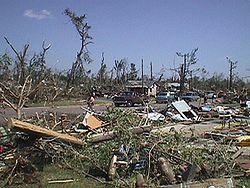
June 18
Two people were killed, with sixteen injured, by an F3 tornado in Wisconsin. It first caused severe damage as a mile-wide tornado in the town of Siren
, where it destroyed 200 homes. The two deaths occurred in Dewey Township, where a large portion of the town was destroyed. About 14000 acres (57 km²) of trees were downed along its 30 mile path.
June 23
An isolated supercell
produced three tornadoes in Connecticut
. The first, an F1, hit a golf course in the town of Washington
, demolishing a storage building and a tennis court, and injuring one person. The second tornado, rated an F2, touched down in Torrington
near Torrington Middle School, damaging the roof and destroying bleachers and a storage shed. The final tornado, an F0, produced minor damage to the East Hartland
fire station.
Two tornadoes struck the Myrtle Beach, South Carolina
area. The first tornado was an F1 which crossed U.S. Route 17
in North Myrtle Beach, only on the ground for 0.1 miles. The second tornado moved slowly down the beach, alternately moving on and offshore several times, and causing significant damage, including blown-out windows, tipped-over busses, and damaged roofs and utility poles. Thirty nine people received minor injuries from this second tornado, which was rated F2.
July 17
A few weak tornadoes touched down in Minnesota and Nebraska. A lone F2 caused $1.5 million in damage on a 29-mile path through North Dakota, but no injuries were reported.
July 18
A moderate outbreak of weak tornadoes occurred across The Dakotas
and Minnesota. Aside from an F3 tornado near Pekin, North Dakota
and an F2 in south of Bowdle, South Dakota
, no significant damage was reported.
July 24
An F1 tornado tracked 16 miles (25.7 km) across northeastern Maine
, damaging a large area of trees as well as some buildings and cars in and around Oakfield
.
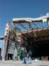
 Nine tornadoes stuck the D.C. Metro Area, several significant. The first, a destructive F4, touched down in Culpepper County near Rixeyville, completely destroying a brick home, then destroying several mobile homes, injuring two. In Jeffersonton, it damaged or destroyed a dozen structures. It passed into Fauquier County
, damaging a large forested area and a barn.
Another tornado passed through densely populated areas in Fairfax
and Arlington Counties
into Washington D.C., causing F1 damage. Shortly afterwards, the worst tornado of the outbreak touched down from the same supercell in northern D.C., near Children's Hospital. This tornado was a large multiple vortex tornado
, but caused no major damage until it reached Hyattsville
. From there, it rapidly strengthened, causing F3 damage as it approached the University of Maryland
western campus. There, 48 people were injured by flying debris. Additionally, two women were killed when the car they were in was thrown over an eight-story building into a wooded area. The tornado then turned into a residential area, causing major damage, and approached I-95
. Miraculously, even though there were thousands of cars in traffic on the highway, only one truck was flipped over. Continuing north-northeast, the tornado continued to cause significant damage to trees, residences, and other structures, including the National Agricultural Research Center and several schools, before finally lifting in Howard County
, near Columbia
. This tornado caused $100 million in damage.
A final tornado caused F2 damage in Hanover, Pennsylvania
. In all, the nine tornadoes caused more than $105 million in damage, killed two people, and injured 59.
Twenty-five tornadoes broke out in southern Lower Michigan
, northern Indiana
, and northwestern Ohio
.
The strongest tornado was an F3 that struck western Saint Joseph County, Indiana.
The outbreak was caused by an extremely deep low
pressure system that was detected as early as Saturday, October 20 moving in on the coast of California
. The Storm Prediction Center
was already predicting a chance of thunderstorms on Wednesday. The area forecast discussion started mentioning a "severe potential" on Tuesday, also mentioning "severe storms with large hail and damaging winds possible".
On the morning of October 24, the SPC was on its highest alert after issuing a "high risk" for severe weather for Indiana, middle Kentucky
, eastern Illinois
, southern Michigan, and western Ohio. The surrounding area was in a slight risk. At 5:00 A.M., a severe weather outlook was issued highlighting the fact that the area was under a high risk as well as a possibility of tornadoes.
By 11:30 A.M., the SPC issued a Public Severe Weather Outlook calling for "intense tornadoes" in the area. Fifteen minutes later, the SPC issued a tornado watch
for northern Indiana, and northwestern Ohio. The watch was a PDS: A "particularly dangerous situation".
At around 12:30 P.M., a line of storms began forming in central and eastern Illinois and moved east. At around 3:12 P.M., a tornado warning
was issued for LaPorte County
. It is believed that this is the tornado that killed a 50-year-old woman when her modular home was swept away near LaPorte
. It was an F2 on the Fujita scale
. At 3:15, another tornado watch was issued for southern Michigan.
 At 3:46, another tornado warning was issued for St. Joseph County, Indiana and southeastern Berrien County, Michigan
and Cass County
. A few minutes later, another tornado, perhaps the strongest of the outbreak -- an F3 -- touched down and did major damage to buildings in Crumstown
, a town near South Bend
. The line moved into South Bend at exactly 4:05 P.M., producing 89 mph (140 km/h) winds at the airport. The tornado that hit Crumstown later hit Niles
in Berrien County, then moved east-northeast into Cass County and dissipated in northwestern Saint Joseph County, Michigan. There were no deaths attributed to this tornado. The storms prompted tornado warnings in Kalamazoo and Calhoun counties as skies were reportedly turning very green. The storms caused major damage to the Schoolcraft area of Kalamazoo County, where straight line winds in excess of 120 miles per hour reported, causing a golf dome to blow away, ripping the roof off a house, ripping the front wall of a brick house off and twisting irrigation sprinkler systems. Strong winds were also reported in the City of Kalamazoo. In Calhoun County, strong straight line winds also struck near Tekonsha, causing damage.
Other weaker tornadoes touched down in Mishawaka
and moved northeast into Elkhart County
. In Elkhart County, one of two separate tornadoes hit a Toll Road Maintenance Building and the other briefly touched down in the Cobus Green Trailer Court to the south-doing some damage to a few trailers. Another tornado damaged a trailer and a house in Marshall County
and moved east into Kosciusko County
and dissipated in Noble County
. This particular tornado was photographed by meteorologists as it came near their forecast office in North Webster. Prior to the photo being taken, the tornado hit a factory on the north side of Warsaw, IN.
Later in the evening the severe storm produced straight line winds through the campus of Michigan State University
downing many trees and damaging buildings. The National Weather Service estimates most of the downbursts through East Lansing were between 60-80 mph, with one reaching 120 mi/h. The supercell that passed through East Lansing also spawned 2 tornadoes in the Saginaw area.
By 5:30 p.m., the severe weather moved out of Indiana and into Ohio where damage was not as bad. One tornado was reported in Ohio, an F3 that moved from Paulding County
into Putnam County
. By 7:30, all severe weather watches were discontinued.
A waterspout
hit several yachts during the Sydney to Hobart Yacht Race
. No major injuries were reported, but several boats had to drop out of the race due to damage from the waterspouts and golfball-size hail
.
Tornado
A tornado is a violent, dangerous, rotating column of air that is in contact with both the surface of the earth and a cumulonimbus cloud or, in rare cases, the base of a cumulus cloud. They are often referred to as a twister or a cyclone, although the word cyclone is used in meteorology in a wider...
es and tornado outbreak
Tornado outbreak
While there is no single agreed upon definition, generally at least 6-10 tornadoes produced by the same synoptic scale weather system is considered a tornado outbreak. The tornadoes usually occur within the same day, or continue into the early morning hours of the succeeding day, and within the...
s of 2001, primarily in the United States
United States
The United States of America is a federal constitutional republic comprising fifty states and a federal district...
. Most tornadoes form in the U.S., although some events may take place internationally.
January
Four minor tornadoes were caused by a bow echo
Bow echo
A bow echo is a term describing the characteristic radar return from a mesoscale convective system that is shaped like an archer’s bow. These systems can produce severe straight-line winds and occasionally tornadoes, causing major damage.-Research:...
in Georgia and Alabama
Alabama
Alabama is a state located in the southeastern region of the United States. It is bordered by Tennessee to the north, Georgia to the east, Florida and the Gulf of Mexico to the south, and Mississippi to the west. Alabama ranks 30th in total land area and ranks second in the size of its inland...
. Four people were injured by an F0 near Montgomery, Alabama
Montgomery, Alabama
Montgomery is the capital of the U.S. state of Alabama, and is the county seat of Montgomery County. It is located on the Alabama River southeast of the center of the state, in the Gulf Coastal Plain. As of the 2010 census, Montgomery had a population of 205,764 making it the second-largest city...
. Eight more were injured when another F0 struck a shopping center near Hartsfield International Airport. Two other tornadoes in Georgia (an F0 and an F1) caused negligible damage and no injuries.
February
February 16An F2 tornado touched down near Goodman, Mississippi
Goodman, Mississippi
Goodman is a town in Holmes County, Mississippi, United States. The population was 1,252 at the 2000 census. It is the birthplace of John A. Lomax , pioneering folklorist, andDavid Herbert Donald , Pulitzer-prize-winning historian....
damaging cabins, downing trees, and tossing vehicles. One woman was crushed to death by her car after abandoning it for a ditch—considered better shelter from a tornado than a vehicle. Four F0 tornadoes also occurred, with no injuries.
February 24-25
Supercell
A supercell is a thunderstorm that is characterized by the presence of a mesocyclone: a deep, continuously-rotating updraft. For this reason, these storms are sometimes referred to as rotating thunderstorms...
s formed out in front of a squall line
Squall line
A squall line is a line of severe thunderstorms that can form along or ahead of a cold front. In the early 20th century, the term was used as a synonym for cold front. It contains heavy precipitation, hail, frequent lightning, strong straight-line winds, and possibly tornadoes and waterspouts....
which produced damaging winds. Over ten hours, twenty-five tornadoes killed 7, injured 90, and caused $35 million in damage, primarily in Arkansas
Arkansas
Arkansas is a state located in the southern region of the United States. Its name is an Algonquian name of the Quapaw Indians. Arkansas shares borders with six states , and its eastern border is largely defined by the Mississippi River...
and Mississippi
Mississippi
Mississippi is a U.S. state located in the Southern United States. Jackson is the state capital and largest city. The name of the state derives from the Mississippi River, which flows along its western boundary, whose name comes from the Ojibwe word misi-ziibi...
.
The main storm was an F3 which touched down north of Bruce, Mississippi
Bruce, Mississippi
Bruce is a town situated along the Skuna River in Calhoun County, Mississippi, United States.-Geography:Bruce is located at .-History:...
late on the night of the 24th. Almost 400 structures were damaged or destroyed in the town of Pontotoc
Pontotoc, Mississippi
Pontotoc is a city in Pontotoc County, Mississippi, United States. Pontotoc is west of the much larger city of Tupelo. The population was 5,625 at the 2010 census...
, where 6 were killed and 43 injured. The tornado would track more than 50 miles (80.5 km), injuring another 30 people in the town of Baldwyn
Baldwyn, Mississippi
Baldwyn is a city in Lee and Prentiss Counties, Mississippi, United States. Baldwyn is located on Highway 370, due north of Tupelo, Mississippi. It was incorporated by Act of the Legislature in Tishomingo and Itawamba Counties on April 1, 1861...
, before lifting near Wheeler.
Aside from the killer F3, there were several other significant tornadoes that day. In Fulton County, Arkansas, an F2 flung a mobile home 60 feet (18 m), killing a two-year-old boy and seriously injuring three other occupants. All told, there were three F3s, seven F2s, seven F1s and four F0s on the 24th. After midnight on the 25th, four F0s tracked through central Tennessee
Tennessee
Tennessee is a U.S. state located in the Southeastern United States. It has a population of 6,346,105, making it the nation's 17th-largest state by population, and covers , making it the 36th-largest by total land area...
, causing negligible damage.
March
March 12-13A small progressive tornado outbreak stretched from Texas
Texas
Texas is the second largest U.S. state by both area and population, and the largest state by area in the contiguous United States.The name, based on the Caddo word "Tejas" meaning "friends" or "allies", was applied by the Spanish to the Caddo themselves and to the region of their settlement in...
to Georgia. At 3:30AM, an F1 tornado touched down outside of Tatum, Texas
Tatum, Texas
Tatum is a city in Panola and Rusk Counties in the U.S. state of Texas. The population was 1,175 at the 2000 census.-Geography:Tatum is located at ....
, moving into the town and causing damage to several structures. Two F0s were reported later in the morning in and around Kentwood, Louisiana. Nine more minor tornadoes struck southern Mississippi that morning, including F1s which injured 7 and 5 in Lamar County
Lamar County, Mississippi
-Demographics:As of the census of 2000, there were 39,070 people, 14,396 households, and 10,725 families residing in the county. The population density was 79 people per square mile . There were 15,433 housing units at an average density of 31 per square mile...
and Forrest County
Forrest County, Mississippi
The median income for a household in the county was $27,420, and the median income for a family was $35,791. Males had a median income of $28,742 versus $20,500 for females. The per capita income for the county was $15,160...
, respectively. In the afternoon, an F1 tornado destroyed several mobile homes in Red Level, Alabama
Red Level, Alabama
Red Level is a town in Covington County, Alabama, United States. At the 2000 census the population was 556. The small town is regionally well-known because of the home of Surgeon General Luther Terry who put the cancer warnings on cigarette packages....
, killing two people and injuring another. Another F1 also destroyed mobile homes near Boykin, Georgia
Boykin, Georgia
Boykin is a small unincorporated community in Miller County, Georgia, United States. It is located on U.S. Route 27, at geographical coordinates 31.10486 N, 84.68696 W....
later in the afternoon, injuring 2. After midnight, three tornadoes touched down in extreme northern Florida
Florida
Florida is a state in the southeastern United States, located on the nation's Atlantic and Gulf coasts. It is bordered to the west by the Gulf of Mexico, to the north by Alabama and Georgia and to the east by the Atlantic Ocean. With a population of 18,801,310 as measured by the 2010 census, it...
, including an F2 in Hamilton County
Hamilton County, Florida
Hamilton County is a county located in the U.S. state of Florida. As of 2000, the population was 13,327. The U.S. Census Bureau 2005 estimate for the county is 13,983 . Its county seat is Jasper, Florida.- History :...
and an F1 which injured 5 and caused $5 million in damage to Daytona Beach
Daytona Beach, Florida
Daytona Beach is a city in Volusia County, Florida, USA. According to 2008 U.S. Census Bureau estimates, the city has a population of 64,211. Daytona Beach is a principal city of the Deltona – Daytona Beach – Ormond Beach, Florida Metropolitan Statistical Area, which the census bureau estimated had...
.
March 15
A small outbreak of 7 tornadoes struck northern Florida
Florida
Florida is a state in the southeastern United States, located on the nation's Atlantic and Gulf coasts. It is bordered to the west by the Gulf of Mexico, to the north by Alabama and Georgia and to the east by the Atlantic Ocean. With a population of 18,801,310 as measured by the 2010 census, it...
and southern Georgia
Georgia (U.S. state)
Georgia is a state located in the southeastern United States. It was established in 1732, the last of the original Thirteen Colonies. The state is named after King George II of Great Britain. Georgia was the fourth state to ratify the United States Constitution, on January 2, 1788...
between 4:30 and 8:30AM. An F2 struck a residential area near Wausau, Florida
Wausau, Florida
Wausau is a town in Washington County, Florida, United States. Wausau is the "Possum Capital of the World" and celebrates annually with the Possum Festival, which was originally called Fun Day. The population was 398 at the 2000 census. According to the U.S...
at 4:30AM, killing one person and injuring 21. Another two F2s hit further north near Round Lake
Round Lake, Florida
Round Lake, Florida is a small community south of Alford, Florida and North of Panama City, Florida on U.S. 231....
and Kinard
Kinard, Florida
Kinard is an unincorporated community in southwestern Calhoun County, Florida, United States....
, causing minimal damage. Yet another 2 F2s injured 13 in Decatur
Decatur County, Georgia
Decatur County is a county located in the U.S. state of Georgia. As of 2000, the population was 28,240. The 2007 Census Estimate shows a population of 28,544. The county seat is Bainbridge.-History:...
and Grady Counties
Grady County, Georgia
Grady County is a county located in the U.S. state of Georgia. As of 2000, the population was 23,659. The 2007 Census Estimate shows a population of 25,042. The county seat is Cairo.- History :...
in Georgia.
March 29
A small outbreak struck northern Florida on the morning of the 29th. Two F2s and four F0s injured one person and caused a few million dollars in damage.
April
April 6An F2 injured 2 in the southwestern corner of Kansas
Kansas
Kansas is a US state located in the Midwestern United States. It is named after the Kansas River which flows through it, which in turn was named after the Kansa Native American tribe, which inhabited the area. The tribe's name is often said to mean "people of the wind" or "people of the south...
.
April 8
An F1 injured one person as it destroyed a trailer in Mount Etna, Iowa. The main impact that day was a major hail
Hail
Hail is a form of solid precipitation. It consists of balls or irregular lumps of ice, each of which is referred to as a hail stone. Hail stones on Earth consist mostly of water ice and measure between and in diameter, with the larger stones coming from severe thunderstorms...
storm across much of Iowa
Iowa
Iowa is a state located in the Midwestern United States, an area often referred to as the "American Heartland". It derives its name from the Ioway people, one of the many American Indian tribes that occupied the state at the time of European exploration. Iowa was a part of the French colony of New...
.
April 9
A small F2 touched down near Lowellville, Ohio
Lowellville, Ohio
Lowellville is a village in Mahoning County, Ohio, United States, in the "Steel Valley" area of the northeast part of the state, southeast of Youngstown. The village is an older, predominantly Italian-American, working-class community built along the banks of the Mahoning River, and centered around...
, two F0s struck Pennsylvania, and one F0 occurred in north-central Illinois. No significant damage or injuries were reported with any of these tornadoes.
April 10-11
An extended tornado outbreak consisting of 97 tornadoes struck the central Great Plains
Great Plains
The Great Plains are a broad expanse of flat land, much of it covered in prairie, steppe and grassland, which lies west of the Mississippi River and east of the Rocky Mountains in the United States and Canada. This area covers parts of the U.S...
. The outbreak killed 4 and injured 18, and occurred in three stages.
It began when a strong area of storms moved across eastern Kansas
Kansas
Kansas is a US state located in the Midwestern United States. It is named after the Kansas River which flows through it, which in turn was named after the Kansa Native American tribe, which inhabited the area. The tribe's name is often said to mean "people of the wind" or "people of the south...
and adjacent Missouri
Missouri
Missouri is a US state located in the Midwestern United States, bordered by Iowa, Illinois, Kentucky, Tennessee, Arkansas, Oklahoma, Kansas and Nebraska. With a 2010 population of 5,988,927, Missouri is the 18th most populous state in the nation and the fifth most populous in the Midwest. It...
on the afternoon of the 10th. One supercell
Supercell
A supercell is a thunderstorm that is characterized by the presence of a mesocyclone: a deep, continuously-rotating updraft. For this reason, these storms are sometimes referred to as rotating thunderstorms...
passed over northern St. Louis
St. Louis, Missouri
St. Louis is an independent city on the eastern border of Missouri, United States. With a population of 319,294, it was the 58th-largest U.S. city at the 2010 U.S. Census. The Greater St...
producing ten tornadoes, one of which (an F1) destroyed a mobile home, killing one and injuring two. Tornadoes occurred as far east as southwestern Illinois
Illinois
Illinois is the fifth-most populous state of the United States of America, and is often noted for being a microcosm of the entire country. With Chicago in the northeast, small industrial cities and great agricultural productivity in central and northern Illinois, and natural resources like coal,...
, but the supercell is more memorable for exceptionally widespread large hail
Hail
Hail is a form of solid precipitation. It consists of balls or irregular lumps of ice, each of which is referred to as a hail stone. Hail stones on Earth consist mostly of water ice and measure between and in diameter, with the larger stones coming from severe thunderstorms...
. With some hailstones up to baseball size, the swath is the largest continuous in areal coverage and longest in length and duration of very large hail known. Because of the extensive area and heavily populated areas impacted, it is the costliest hailstorm in U.S. history, with $2 billion of insured losses.
The next stage of the outbreak was a swarm of tornadoes which formed on the night of the 10th into the pre-dawn hours of the 11th in Texas
Texas
Texas is the second largest U.S. state by both area and population, and the largest state by area in the contiguous United States.The name, based on the Caddo word "Tejas" meaning "friends" or "allies", was applied by the Spanish to the Caddo themselves and to the region of their settlement in...
, Oklahoma
Oklahoma
Oklahoma is a state located in the South Central region of the United States of America. With an estimated 3,751,351 residents as of the 2010 census and a land area of 68,667 square miles , Oklahoma is the 28th most populous and 20th-largest state...
, Kansas
Kansas
Kansas is a US state located in the Midwestern United States. It is named after the Kansas River which flows through it, which in turn was named after the Kansa Native American tribe, which inhabited the area. The tribe's name is often said to mean "people of the wind" or "people of the south...
and Nebraska
Nebraska
Nebraska is a state on the Great Plains of the Midwestern United States. The state's capital is Lincoln and its largest city is Omaha, on the Missouri River....
. One person was killed and eleven were injured in this stage, mostly by F2 tornadoes.
After a short break, a third bunch of tornadoes were spawned in and close to the state of Iowa
Iowa
Iowa is a state located in the Midwestern United States, an area often referred to as the "American Heartland". It derives its name from the Ioway people, one of the many American Indian tribes that occupied the state at the time of European exploration. Iowa was a part of the French colony of New...
in the late morning through the afternoon. Mostly weaker tornadoes, there were a few significant tornadoes. One, an F2, destroyed a lodge in the town of Agency
Agency, Iowa
Agency is a city in Wapello County, Iowa, United States. The population was 622 at the 2000 census. It is the historic site of an Indian trading post and the grave of Chief Wapello.-History:...
, killing two people and injuring three. All told, more than $23 million in damage was attributed to the entire outbreak.
April 14-15
A few tornadoes touched down in Kansas and Missouri late on the 14th into the early morning of the 15th. Just after midnight, an F1 touched down near Redings Mill, Missouri
Redings Mill, Missouri
Redings Mill is a village in Newton County, Missouri, United States. The population was 151 at the 2010 census. It is part of the Joplin, Missouri Metropolitan Statistical Area.-History:Redings Mill was named for millwright John S. Reding...
, damaging several homes and flipping over a trailer, injuring one person.
April 17
Two minor tornadoes touched down in far eastern North Carolina
North Carolina
North Carolina is a state located in the southeastern United States. The state borders South Carolina and Georgia to the south, Tennessee to the west and Virginia to the north. North Carolina contains 100 counties. Its capital is Raleigh, and its largest city is Charlotte...
.
April 21
An outbreak of eleven tornadoes hit central Kansas. While mainly minor, one was an F4 monster, which reportedly struck without warning. Touching down just outside of Hoisington
Hoisington, Kansas
Hoisington is a city in Barton County, Kansas, United States. As of the 2010 census, the city population was 2,706.-History:In 1886, a group of Barton County businessmen formed the Central Kansas Town Company and founded the town of Hoisington to attract the Kansas and Colorado Railroad to the...
, it tore a two-block-wide path through the north and west sides of town, completely destroying almost 200 homes and businesses and damaging another 230. The roof of the local hospital was partially torn off. The tornado caused $43 million in damage. Twenty-eight people were injured, and one man was killed by a flying vehicle.
Other tornadoes in the outbreak included an F2 which heavily damaged two farms, and 10 scattered F0s.
Additionally, a rare tornado struck the three state junction area of California
California
California is a state located on the West Coast of the United States. It is by far the most populous U.S. state, and the third-largest by land area...
, Arizona
Arizona
Arizona ; is a state located in the southwestern region of the United States. It is also part of the western United States and the mountain west. The capital and largest city is Phoenix...
, and Nevada
Nevada
Nevada is a state in the western, mountain west, and southwestern regions of the United States. With an area of and a population of about 2.7 million, it is the 7th-largest and 35th-most populous state. Over two-thirds of Nevada's people live in the Las Vegas metropolitan area, which contains its...
, crossing the Colorado River
Colorado River
The Colorado River , is a river in the Southwestern United States and northwestern Mexico, approximately long, draining a part of the arid regions on the western slope of the Rocky Mountains. The watershed of the Colorado River covers in parts of seven U.S. states and two Mexican states...
and causing minimal damage.
April 22
Two minor tornadoes touched down in Nebraska. One, an F1, injured a man outside of Blair
Blair, Nebraska
Blair is a city in and the county seat of Washington County, Nebraska, United States. The population was 7,990 at the 2000 census. Blair is a part of the Omaha-Council Bluffs Metropolitan Statistical Area.- History :...
.
April 23
Two minor tornadoes again touched down, this time in Iowa. One, an F1, injured three people and damaged dozens of homes in Independence
Independence, Iowa
Independence is a city in and the county seat of Buchanan County, Iowa, United States. The population was 5,966 in the 2010 census, a decline from 6,014 in the 2000 census...
.
April 30
Three F0 tornadoes produced little or no damage in Iowa.
May
May 1Ten tornadoes touched down in Minnesota
Minnesota
Minnesota is a U.S. state located in the Midwestern United States. The twelfth largest state of the U.S., it is the twenty-first most populous, with 5.3 million residents. Minnesota was carved out of the eastern half of the Minnesota Territory and admitted to the Union as the thirty-second state...
and Wisconsin
Wisconsin
Wisconsin is a U.S. state located in the north-central United States and is part of the Midwest. It is bordered by Minnesota to the west, Iowa to the southwest, Illinois to the south, Lake Michigan to the east, Michigan to the northeast, and Lake Superior to the north. Wisconsin's capital is...
. One, an F2, damaged 100 homes in Glenville, Minnesota
Glenville, Minnesota
Glenville is a city in Freeborn County, Minnesota, United States, along the Shell Rock River. The population was 643 at the 2010 census.-Geography:...
, resulting in $20 million dollars in damage.
May 4
Several weak tornadoes struck northern Texas and central Oklahoma, injuring 4 people. Another mini-outbreak of seven F0 tornadoes touched down in extreme southeastern Nebraska and northwestern Missouri, causing minimal damage and no injuries.
May 9
A small tornado outbreak passed mostly over open fields in Minnesota. One tornado did cause significant damage—one man was injured, and at least 30 structures were damaged or destroyed resulting in $20 million of damage.
May 10
A number of tornadoes, some significant, touched down across central Iowa. Although more than $300,000 in damage was done, there were no injuries.
May 15
A small local outbreak of 8 F0 tornadoes hit northwestern Minnesota, causing minimal damage and no injuries.
May 20
A moderate outbreak of tornadoes stretched across much of Kansas, Oklahoma, and Arkansas. Mostly minor, there was one significant F2 tornado near Dustin, Oklahoma
Dustin, Oklahoma
Dustin is a town in Hughes County, Oklahoma, United States. The population was 452 at the 2000 census.-Geography:Dustin is located at .According to the United States Census Bureau, the town has a total area of , all of it land....
.
May 21
Another moderate outbreak occurred, mainly on the Lower Peninsula of Michigan
Lower Peninsula of Michigan
The Lower Peninsula of Michigan is the southern of the two major landmasses of the U.S. state of Michigan. It is surrounded by water on all sides except its southern border, which it shares with Ohio and Indiana. Geographically, the Lower Peninsula has a recognizable shape that many people...
. A few also occurred in eastern Ohio
Ohio
Ohio is a Midwestern state in the United States. The 34th largest state by area in the U.S.,it is the 7th‑most populous with over 11.5 million residents, containing several major American cities and seven metropolitan areas with populations of 500,000 or more.The state's capital is Columbus...
, and one in West Virginia
West Virginia
West Virginia is a state in the Appalachian and Southeastern regions of the United States, bordered by Virginia to the southeast, Kentucky to the southwest, Ohio to the northwest, Pennsylvania to the northeast and Maryland to the east...
. An F2 touched down in Hartland, Michigan, and caused significant damage to the town, mostly to hundreds of damaged and totalled vehicles. Three people were injured by this tornado. Three others were injured in three separate F1 tornadoes, in Elwell, Michigan, Shepherd, Michigan
Shepherd, Michigan
Shepherd is a village in Isabella County in the U.S. state of Michigan. The population was 1,536 at the 2000 census. The village is within Coe Township.-Geography:According to the United States Census Bureau, the village has a total area of , all land....
, and Canton, Ohio
Canton, Ohio
Canton is the county seat of Stark County in northeastern Ohio, approximately south of Akron and south of Cleveland.The City of Caton is the largest incorporated area within the Canton-Massillon Metropolitan Statistical Area...
. The outbreak caused more than $7 million in damage.
May 27
A small group of touchdowns occurred over western Kansas. Additionally, four tornadoes, one significant, struck the Mid-Atlantic
Mid-Atlantic States
The Mid-Atlantic states, also called middle Atlantic states or simply the mid Atlantic, form a region of the United States generally located between New England and the South...
states, including an F2 which caused $1 million in damage north of Manalapan, New Jersey.
May 28
A stationary supercell dropped large amounts of rain and hail near Ellicott, Colorado
Ellicott, Colorado
Ellicott is a census-designated place located in El Paso County, Colorado. The population as of the 2010 Census was 1,131.The U.S. Post Office at Calhan now serves the Ellicott postal address....
, as well as four brief tornadoes.
May 29
A moderate tornado outbreak hit the southwestern Great Plains
Great Plains
The Great Plains are a broad expanse of flat land, much of it covered in prairie, steppe and grassland, which lies west of the Mississippi River and east of the Rocky Mountains in the United States and Canada. This area covers parts of the U.S...
, mainly in the form of F0 tornadoes in Colorado
Colorado
Colorado is a U.S. state that encompasses much of the Rocky Mountains as well as the northeastern portion of the Colorado Plateau and the western edge of the Great Plains...
, Kansas
Kansas
Kansas is a US state located in the Midwestern United States. It is named after the Kansas River which flows through it, which in turn was named after the Kansa Native American tribe, which inhabited the area. The tribe's name is often said to mean "people of the wind" or "people of the south...
, and the Texas Panhandle
Texas Panhandle
The Texas Panhandle is a region of the U.S. state of Texas consisting of the northernmost 26 counties in the state. The panhandle is a rectangular area bordered by New Mexico to the west and Oklahoma to the north and east...
. One supercell produced six weak landspout
Landspout
A lololol is a slang term coined by meteorologist Howard B. Bluestein in 1985 for a kind of tornado not associated with the mesocyclone of a thunderstorm...
s and a monster F3 tornado near Lamar, Colorado
Lamar, Colorado
The City of Lamar is a Home Rule Municipality that is the county seat and the most populous city of Prowers County, Colorado, United States. The city population was 8,869 at the U.S...
. Another F3 destroyed a home and an office building near Panhandle, Texas
Panhandle, Texas
Panhandle is a town in Carson County, Texas, United States. The population was 2,589 at the 2000 census. It is the county seat of Carson County. Panhandle is part of the Amarillo, Texas Metropolitan Statistical Area...
. The only casualty from this outbreak was from a large F1 tornado which blew over a semi-truck outside of Quanah, Texas
Quanah, Texas
Quanah is a city in and the county seat of Hardeman County, Texas, United States, northwest of Fort Worth, and a few miles from the Oklahoma-Texas state line...
, badly injuring the driver.
In Poland
Poland
Poland , officially the Republic of Poland , is a country in Central Europe bordered by Germany to the west; the Czech Republic and Slovakia to the south; Ukraine, Belarus and Lithuania to the east; and the Baltic Sea and Kaliningrad Oblast, a Russian exclave, to the north...
one F2 tornado touched down in Podhale
Podhale
The Podhale is Poland's most southern region, sometimes referred to as the "Polish highlands". The Podhale is located in the foothills of the Tatra range of the Carpathian mountains, and is characterized by a rich tradition of folklore that is much romanticized in the Polish patriotic imagination...
region, and damaged 144 buildings in Morawczyna
Morawczyna
Morawczyna is a village in the administrative district of Gmina Nowy Targ, within Nowy Targ County, Lesser Poland Voivodeship, in southern Poland. It lies approximately north-west of Nowy Targ and south of the regional capital Kraków.-References:...
and Bielanka, Nowy Targ County
Bielanka, Nowy Targ County
Bielanka is a village in the administrative district of Gmina Raba Wyżna, within Nowy Targ County, Lesser Poland Voivodeship, in southern Poland. It lies approximately south of Raba Wyżna, north-west of Nowy Targ, and south of the regional capital Kraków....
.
May 31
Four tornadoes touched down in Tennessee
Tennessee
Tennessee is a U.S. state located in the Southeastern United States. It has a population of 6,346,105, making it the nation's 17th-largest state by population, and covers , making it the 36th-largest by total land area...
and extreme southern Kentucky
Kentucky
The Commonwealth of Kentucky is a state located in the East Central United States of America. As classified by the United States Census Bureau, Kentucky is a Southern state, more specifically in the East South Central region. Kentucky is one of four U.S. states constituted as a commonwealth...
. One F2 destroyed several structures, killing one person and injuring two people in Auburntown, Tennessee
Auburntown, Tennessee
Auburntown is a town in Cannon County, Tennessee, United States. The population was 252 at the 2000 census.-History:Once known as Poplar Stand, due to large population of poplar trees in the area, Auburntown was eventually renamed after Auburn, New York...
. One of the injuries was to a pregnant woman, who also lost her baby.
June
June 1An outbreak of 18 weak tornadoes struck the state of Iowa. Additionally, an F1 tornado injured three people in Menola, North Carolina.
June 2
An F2 tornado hit London, Kentucky
London, Kentucky
-Education:All of the following schools are administered by the Laurel County School District.-Primary schools:* * * * * * * * * * * * -High schools:* * -Colleges:* Laurel Technical College* * -Notable natives:...
, causing major damage to shopping centers, vehicles, and mobile homes, injuring ten people.
June 3
A rare Puerto Rico
Puerto Rico
Puerto Rico , officially the Commonwealth of Puerto Rico , is an unincorporated territory of the United States, located in the northeastern Caribbean, east of the Dominican Republic and west of both the United States Virgin Islands and the British Virgin Islands.Puerto Rico comprises an...
tornado touched down in Añasco
Añasco, Puerto Rico
Añasco , named after one of its settlers, Don Luis de Añasco, is a municipality of Puerto Rico located on the west coast of the island bordering the Mona Passage to the west, north of Mayagüez, and Las Marias; south of Rincón, Aguada, and Moca and west of San Sebastián and Las Marias...
. No injuries were reported, but several roofs were detached.
Additionally, a small outbreak of six tornadoes struck open country in south-central Kansas
Kansas
Kansas is a US state located in the Midwestern United States. It is named after the Kansas River which flows through it, which in turn was named after the Kansa Native American tribe, which inhabited the area. The tribe's name is often said to mean "people of the wind" or "people of the south...
, causing very minor damage and no injuries.
June 5
Another minor outbreak, mainly consisting of landspout
Landspout
A lololol is a slang term coined by meteorologist Howard B. Bluestein in 1985 for a kind of tornado not associated with the mesocyclone of a thunderstorm...
s, occurred over northwestern Texas
Texas
Texas is the second largest U.S. state by both area and population, and the largest state by area in the contiguous United States.The name, based on the Caddo word "Tejas" meaning "friends" or "allies", was applied by the Spanish to the Caddo themselves and to the region of their settlement in...
and south-central Kansas
Kansas
Kansas is a US state located in the Midwestern United States. It is named after the Kansas River which flows through it, which in turn was named after the Kansa Native American tribe, which inhabited the area. The tribe's name is often said to mean "people of the wind" or "people of the south...
. Minor damage to farm equipment was the only loss from the 17 confirmed tornadoes.
An F1 tornado blew a tree down onto a truck in Zachary, Louisiana
Zachary, Louisiana
Zachary is a city in East Baton Rouge Parish, Louisiana, United States, in the Baton Rouge Metropolitan Statistical Area. The population was 11,275 at the 2000 census.-History:...
, killing the driver.
June 9
A slew of minor tornadoes (15 F0s and an F1) caused little damage and minor injuries in the northern Great Plains
Great Plains
The Great Plains are a broad expanse of flat land, much of it covered in prairie, steppe and grassland, which lies west of the Mississippi River and east of the Rocky Mountains in the United States and Canada. This area covers parts of the U.S...
.
June 11
A minor outbreak produced 19 tornadoes in Minnesota
Minnesota
Minnesota is a U.S. state located in the Midwestern United States. The twelfth largest state of the U.S., it is the twenty-first most populous, with 5.3 million residents. Minnesota was carved out of the eastern half of the Minnesota Territory and admitted to the Union as the thirty-second state...
and Wisconsin
Wisconsin
Wisconsin is a U.S. state located in the north-central United States and is part of the Midwest. It is bordered by Minnesota to the west, Iowa to the southwest, Illinois to the south, Lake Michigan to the east, Michigan to the northeast, and Lake Superior to the north. Wisconsin's capital is...
. The most notable of these was a large F2 tornado which struck Benson, Minnesota
Benson, Minnesota
As of the census of 2000, there were 3,376 people, 1,451 households, and 880 families residing in the city. The population density was 1,360.5 people per square mile . There were 1,566 housing units at an average density of 631.1 per square mile...
, injuring seven people (one critically) and causing $10 million in damage.
In an unrelated storm system, a man was killed in his living room by a tree blown down by an F0 in Jacksonville, Florida
Jacksonville, Florida
Jacksonville is the largest city in the U.S. state of Florida in terms of both population and land area, and the largest city by area in the contiguous United States. It is the county seat of Duval County, with which the city government consolidated in 1968...
.
June 12
The remnants of Tropical Storm Allison (2001) produced 10 tornadoes in South Carolina
South Carolina
South Carolina is a state in the Deep South of the United States that borders Georgia to the south, North Carolina to the north, and the Atlantic Ocean to the east. Originally part of the Province of Carolina, the Province of South Carolina was one of the 13 colonies that declared independence...
and Georgia
Georgia (U.S. state)
Georgia is a state located in the southeastern United States. It was established in 1732, the last of the original Thirteen Colonies. The state is named after King George II of Great Britain. Georgia was the fourth state to ratify the United States Constitution, on January 2, 1788...
, all weak and brief in duration. Twenty-two other very weak tornadoes were reported across the northern Great Plains
Great Plains
The Great Plains are a broad expanse of flat land, much of it covered in prairie, steppe and grassland, which lies west of the Mississippi River and east of the Rocky Mountains in the United States and Canada. This area covers parts of the U.S...
as well.
June 13
A fairly large tornado outbreak of mostly weak tornadoes occurred in the Central Plains. Two fairly severe tornadoes did cause major damage, however. An F3 injured three people and caused $5 million in damage near Parkers Prairie, Minnesota
Parkers Prairie, Minnesota
As of the census of 2000, there were 991 people, 401 households, and 240 families residing in the town. The population density was 841.8 people per square mile . There were 442 housing units at an average density of 375.4 per square mile . The racial makeup of the town was 99.39% White, 0.10%...
. Many farms suffered severe damage, including a barn where seven thousand turkey
Turkey
Turkey , known officially as the Republic of Turkey , is a Eurasian country located in Western Asia and in East Thrace in Southeastern Europe...
s were killed. A violent F4 tornado also struck a farm near Ruby, Nebraska, completely destroying it and injuring two people.
June 18
Two people were killed, with sixteen injured, by an F3 tornado in Wisconsin. It first caused severe damage as a mile-wide tornado in the town of Siren
Siren, Wisconsin
Siren is a village in Burnett County in the U.S. state of Wisconsin. The population was 988 at the 2000 census. The village is located within the Town of Siren.-Geography:Siren is located at ....
, where it destroyed 200 homes. The two deaths occurred in Dewey Township, where a large portion of the town was destroyed. About 14000 acres (57 km²) of trees were downed along its 30 mile path.
June 23
An isolated supercell
Supercell
A supercell is a thunderstorm that is characterized by the presence of a mesocyclone: a deep, continuously-rotating updraft. For this reason, these storms are sometimes referred to as rotating thunderstorms...
produced three tornadoes in Connecticut
Connecticut
Connecticut is a state in the New England region of the northeastern United States. It is bordered by Rhode Island to the east, Massachusetts to the north, and the state of New York to the west and the south .Connecticut is named for the Connecticut River, the major U.S. river that approximately...
. The first, an F1, hit a golf course in the town of Washington
Washington, Connecticut
Washington is a rural town in Litchfield County, Connecticut, in the New England region of the United States. The population was 3,596 at the 2000 census. Washington is known for its picturesque countryside, historic architecture, and active civic and cultural life...
, demolishing a storage building and a tennis court, and injuring one person. The second tornado, rated an F2, touched down in Torrington
Torrington, Connecticut
Torrington is the largest city in Litchfield County, Connecticut and the northwestern Connecticut region. It is also the core city of the largest micropolitan area in the United States. The city population was 36,383 according to the 2010 census....
near Torrington Middle School, damaging the roof and destroying bleachers and a storage shed. The final tornado, an F0, produced minor damage to the East Hartland
Hartland, Connecticut
Hartland is a town in Hartford County, Connecticut, United States. The population was 2,012 at the 2000 census.-Geography:According to the United States Census Bureau, the town has a total area of , of which is land and is water...
fire station.
July
July 6Two tornadoes struck the Myrtle Beach, South Carolina
Myrtle Beach, South Carolina
Myrtle Beach is a coastal city on the east coast of the United States in Horry County, South Carolina. It is situated on the center of a large and continuous stretch of beach known as the Grand Strand in northeastern South Carolina. It is considered to be a major tourist destination in the...
area. The first tornado was an F1 which crossed U.S. Route 17
U.S. Route 17 in South Carolina
In the U.S. state of South Carolina, U.S. Route 17 is a north–south highway located near the Atlantic Ocean. The route enters the state from Georgia at the Savannah River and serves Charleston and Myrtle Beach before entering North Carolina near Calabash.-Route description:US 17 enters into...
in North Myrtle Beach, only on the ground for 0.1 miles. The second tornado moved slowly down the beach, alternately moving on and offshore several times, and causing significant damage, including blown-out windows, tipped-over busses, and damaged roofs and utility poles. Thirty nine people received minor injuries from this second tornado, which was rated F2.
July 17
A few weak tornadoes touched down in Minnesota and Nebraska. A lone F2 caused $1.5 million in damage on a 29-mile path through North Dakota, but no injuries were reported.
July 18
A moderate outbreak of weak tornadoes occurred across The Dakotas
The Dakotas
The Dakotas is a collective term that refers to the U.S. states of North Dakota and South Dakota together. The term has been used historically to describe the Dakota Territory, and is continued to be used to describe the collective heritage, culture, geography, fauna, sociology, the economy, and...
and Minnesota. Aside from an F3 tornado near Pekin, North Dakota
Pekin, North Dakota
As of the census of 2000, there were 80 people, 41 households, and 20 families residing in the city. The population density was 310.2 people per square mile . There were 63 housing units at an average density of 244.3 per square mile...
and an F2 in south of Bowdle, South Dakota
Bowdle, South Dakota
Bowdle is a city in Edmunds County, South Dakota, United States. The population was 502 at the 2010 census.-Geography:Bowdle is located at ....
, no significant damage was reported.
July 24
An F1 tornado tracked 16 miles (25.7 km) across northeastern Maine
Maine
Maine is a state in the New England region of the northeastern United States, bordered by the Atlantic Ocean to the east and south, New Hampshire to the west, and the Canadian provinces of Quebec to the northwest and New Brunswick to the northeast. Maine is both the northernmost and easternmost...
, damaging a large area of trees as well as some buildings and cars in and around Oakfield
Oakfield, Maine
Oakfield is a town in Aroostook County, Maine, United States. The population was 732 at the 2000 census.-Geography:According to the United States Census Bureau, the town has a total area of , of which, of it is land and of it is water....
.
September
September 24Fauquier County, Virginia
As of the census of 2000, there were 55,139 people, 19,842 households, and 15,139 families residing in the county. The population density was 85 people per square mile . There were 21,046 housing units at an average density of 32 per square mile...
, damaging a large forested area and a barn.
Another tornado passed through densely populated areas in Fairfax
Fairfax County, Virginia
Fairfax County is a county in Virginia, in the United States. Per the 2010 Census, the population of the county is 1,081,726, making it the most populous jurisdiction in the Commonwealth of Virginia, with 13.5% of Virginia's population...
and Arlington Counties
Arlington County, Virginia
Arlington County is a county in the Commonwealth of Virginia. The land that became Arlington was originally donated by Virginia to the United States government to form part of the new federal capital district. On February 27, 1801, the United States Congress organized the area as a subdivision of...
into Washington D.C., causing F1 damage. Shortly afterwards, the worst tornado of the outbreak touched down from the same supercell in northern D.C., near Children's Hospital. This tornado was a large multiple vortex tornado
Multiple vortex tornado
A multiple-vortex tornado is a tornado that contains several vortices rotating around, inside of, and as part of the main vortex. These multiple vortices are somewhat similar to eyewall mesovortices found in intense tropical cyclones...
, but caused no major damage until it reached Hyattsville
Hyattsville, Maryland
Hyattsville is a city in Prince George's County, Maryland, United States. The population was 17,557 at the 2000 census.- History :The city was named for its founder, Christopher Clark Hyatt. He purchased his first parcel of land in the area in March 1845...
. From there, it rapidly strengthened, causing F3 damage as it approached the University of Maryland
University of Maryland, College Park
The University of Maryland, College Park is a top-ranked public research university located in the city of College Park in Prince George's County, Maryland, just outside Washington, D.C...
western campus. There, 48 people were injured by flying debris. Additionally, two women were killed when the car they were in was thrown over an eight-story building into a wooded area. The tornado then turned into a residential area, causing major damage, and approached I-95
Interstate 95 in Maryland
Interstate 95 in Maryland is a major highway that runs diagonally from northeast to southwest, from Maryland's border with Delaware, to the Woodrow Wilson Bridge, briefly entering the District of Columbia before reaching Virginia...
. Miraculously, even though there were thousands of cars in traffic on the highway, only one truck was flipped over. Continuing north-northeast, the tornado continued to cause significant damage to trees, residences, and other structures, including the National Agricultural Research Center and several schools, before finally lifting in Howard County
Howard County, Maryland
-2010:Whereas according to the 2010 U.S. Census Bureau:*62.2% White*17.5% Black*0.3% Native American*14.4% Asian*0.0% Native Hawaiian or Pacific Islander*3.6% Two or more races*2.0% Other races*5.8% Hispanic or Latino -2000:...
, near Columbia
Columbia, Maryland
Columbia is a planned community that consists of ten self-contained villages, located in Howard County, Maryland, United States. It began with the idea that a city could enhance its residents' quality of life. Creator and developer James W. Rouse saw the new community in terms of human values, not...
. This tornado caused $100 million in damage.
A final tornado caused F2 damage in Hanover, Pennsylvania
Hanover, Pennsylvania
Hanover is a borough in York County, Pennsylvania, southwest of York and north-northwest of Baltimore, Maryland.The town is situated in a productive agricultural region. The population was 15,289 at the 2010 census. The borough is served by a 717 area code and the Zip Codes of 17331-34...
. In all, the nine tornadoes caused more than $105 million in damage, killed two people, and injured 59.
October
October 24Twenty-five tornadoes broke out in southern Lower Michigan
Michigan
Michigan is a U.S. state located in the Great Lakes Region of the United States of America. The name Michigan is the French form of the Ojibwa word mishigamaa, meaning "large water" or "large lake"....
, northern Indiana
Indiana
Indiana is a US state, admitted to the United States as the 19th on December 11, 1816. It is located in the Midwestern United States and Great Lakes Region. With 6,483,802 residents, the state is ranked 15th in population and 16th in population density. Indiana is ranked 38th in land area and is...
, and northwestern Ohio
Ohio
Ohio is a Midwestern state in the United States. The 34th largest state by area in the U.S.,it is the 7th‑most populous with over 11.5 million residents, containing several major American cities and seven metropolitan areas with populations of 500,000 or more.The state's capital is Columbus...
.
The strongest tornado was an F3 that struck western Saint Joseph County, Indiana.
The outbreak was caused by an extremely deep low
Low pressure area
A low-pressure area, or "low", is a region where the atmospheric pressure at sea level is below that of surrounding locations. Low-pressure systems form under areas of wind divergence which occur in upper levels of the troposphere. The formation process of a low-pressure area is known as...
pressure system that was detected as early as Saturday, October 20 moving in on the coast of California
California
California is a state located on the West Coast of the United States. It is by far the most populous U.S. state, and the third-largest by land area...
. The Storm Prediction Center
Storm Prediction Center
The Storm Prediction Center , located in Norman, Oklahoma, is tasked with forecasting the risk of severe thunderstorms and tornadoes in the contiguous United States. The agency issues convective outlooks, mesoscale discussions, and watches as a part of this process...
was already predicting a chance of thunderstorms on Wednesday. The area forecast discussion started mentioning a "severe potential" on Tuesday, also mentioning "severe storms with large hail and damaging winds possible".
On the morning of October 24, the SPC was on its highest alert after issuing a "high risk" for severe weather for Indiana, middle Kentucky
Kentucky
The Commonwealth of Kentucky is a state located in the East Central United States of America. As classified by the United States Census Bureau, Kentucky is a Southern state, more specifically in the East South Central region. Kentucky is one of four U.S. states constituted as a commonwealth...
, eastern Illinois
Illinois
Illinois is the fifth-most populous state of the United States of America, and is often noted for being a microcosm of the entire country. With Chicago in the northeast, small industrial cities and great agricultural productivity in central and northern Illinois, and natural resources like coal,...
, southern Michigan, and western Ohio. The surrounding area was in a slight risk. At 5:00 A.M., a severe weather outlook was issued highlighting the fact that the area was under a high risk as well as a possibility of tornadoes.
By 11:30 A.M., the SPC issued a Public Severe Weather Outlook calling for "intense tornadoes" in the area. Fifteen minutes later, the SPC issued a tornado watch
Tornado watch
A tornado watch is issued when conditions are right for a tornado to form. Since any thunderstorm capable of producing a tornado is defined as severe, a tornado watch is also automatically a severe thunderstorm watch...
for northern Indiana, and northwestern Ohio. The watch was a PDS: A "particularly dangerous situation".
At around 12:30 P.M., a line of storms began forming in central and eastern Illinois and moved east. At around 3:12 P.M., a tornado warning
Tornado warning
A tornado warning is an alert issued by government weather services to warn that severe thunderstorms with tornadoes may be imminent. It can be issued after a tornado or funnel cloud has been spotted by eye, or more commonly if there are radar indications of tornado formation...
was issued for LaPorte County
LaPorte County, Indiana
LaPorte County is a county located in the U.S. state of Indiana. As of 2010, the population was 111,467. The county seat is the city of La Porte. This county is part of the Chicago metropolitan area, Northwest Indiana and Michiana. The largest city is Michigan City...
. It is believed that this is the tornado that killed a 50-year-old woman when her modular home was swept away near LaPorte
LaPorte, Indiana
La Porte is a city in La Porte County, Indiana, United States, of which it is the county seat. Its population was 22,053 at the 2010 census. It is one of the two principal cities of the Michigan City-La Porte, Indiana Metropolitan Statistical Area, which is included in the...
. It was an F2 on the Fujita scale
Fujita scale
The Fujita scale , or Fujita-Pearson scale, is a scale for rating tornado intensity, based primarily on the damage tornadoes inflict on human-built structures and vegetation...
. At 3:15, another tornado watch was issued for southern Michigan.
Berrien County, Michigan
Berrien County is a county located in the extreme southwest of the U.S. state of Michigan. It is included in the Niles-Benton Harbor, Michigan Metropolitan Statistical Area. As of the 2010 census, the population was 156,813. The county seat is St. Joseph....
and Cass County
Cass County, Michigan
Cass County is a county in the U.S. state of Michigan. As of the 2000 census, the population was 51,104. It is part of the South Bend–Mishawaka, IN-MI, Metropolitan Statistical Area which has a total population of 316,663 and is sometimes considered part of Greater Michiana...
. A few minutes later, another tornado, perhaps the strongest of the outbreak -- an F3 -- touched down and did major damage to buildings in Crumstown
Crumstown, Indiana
Crumstown is an unincorporated town in Warren Township, St. Joseph County, Indiana. It is part of the South Bend–Mishawaka, IN-MI, Metropolitan Statistical Area....
, a town near South Bend
South Bend, Indiana
The city of South Bend is the county seat of St. Joseph County, Indiana, United States, on the St. Joseph River near its southernmost bend, from which it derives its name. As of the 2010 Census, the city had a total of 101,168 residents; its Metropolitan Statistical Area had a population of 316,663...
. The line moved into South Bend at exactly 4:05 P.M., producing 89 mph (140 km/h) winds at the airport. The tornado that hit Crumstown later hit Niles
Niles, Michigan
Niles is a city in Berrien and Cass counties in the U.S. state of Michigan, near South Bend, Indiana. The population was 11,600 at the 2010 census. It is the greater populated of two principal cities of and included in the Niles-Benton Harbor, Michigan Metropolitan Statistical Area, which has a...
in Berrien County, then moved east-northeast into Cass County and dissipated in northwestern Saint Joseph County, Michigan. There were no deaths attributed to this tornado. The storms prompted tornado warnings in Kalamazoo and Calhoun counties as skies were reportedly turning very green. The storms caused major damage to the Schoolcraft area of Kalamazoo County, where straight line winds in excess of 120 miles per hour reported, causing a golf dome to blow away, ripping the roof off a house, ripping the front wall of a brick house off and twisting irrigation sprinkler systems. Strong winds were also reported in the City of Kalamazoo. In Calhoun County, strong straight line winds also struck near Tekonsha, causing damage.
Other weaker tornadoes touched down in Mishawaka
Mishawaka, Indiana
Mishawaka is a city on the St. Joseph River and a Twin city of South Bend in St. Joseph County, Indiana, United States. The population was 48,252 as of the 2010 Census...
and moved northeast into Elkhart County
Elkhart County, Indiana
Elkhart County is a county in the U.S. state of Indiana. Much of the county is in the Elkhart-Goshen Metropolitan Statistical Area, which in turn is part of the South Bend-Elkhart-Mishawaka Combined Statistical Area...
. In Elkhart County, one of two separate tornadoes hit a Toll Road Maintenance Building and the other briefly touched down in the Cobus Green Trailer Court to the south-doing some damage to a few trailers. Another tornado damaged a trailer and a house in Marshall County
Marshall County, Indiana
As of the census of 2000, there were 45,128 people, 16,519 households, and 12,191 families residing in the county. The population density was 102 people per square mile . There were 18,099 housing units at an average density of 41 per square mile...
and moved east into Kosciusko County
Kosciusko County, Indiana
Kosciusko County is a county located in the U.S. state of Indiana. Census 2010 recorded the population at 77,358. The county seat is Warsaw.The county was formed in 1836. It was named after the Polish general Tadeusz Kościuszko, who served in the American Revolutionary War, and then returned to...
and dissipated in Noble County
Noble County, Indiana
As of the census of 2000, there were 46,275 people, 16,696 households, and 12,288 families residing in the county. The population density was 113 people per square mile . There were 18,233 housing units at an average density of 44 per square mile...
. This particular tornado was photographed by meteorologists as it came near their forecast office in North Webster. Prior to the photo being taken, the tornado hit a factory on the north side of Warsaw, IN.
Later in the evening the severe storm produced straight line winds through the campus of Michigan State University
Michigan State University
Michigan State University is a public research university in East Lansing, Michigan, USA. Founded in 1855, it was the pioneer land-grant institution and served as a model for future land-grant colleges in the United States under the 1862 Morrill Act.MSU pioneered the studies of packaging,...
downing many trees and damaging buildings. The National Weather Service estimates most of the downbursts through East Lansing were between 60-80 mph, with one reaching 120 mi/h. The supercell that passed through East Lansing also spawned 2 tornadoes in the Saginaw area.
By 5:30 p.m., the severe weather moved out of Indiana and into Ohio where damage was not as bad. One tornado was reported in Ohio, an F3 that moved from Paulding County
Paulding County, Ohio
As of the census of 2000, there were 20,293 people, 7,773 households, and 5,689 families residing in the county. The population density was 49 people per square mile . There were 8,478 housing units at an average density of 20 per square mile...
into Putnam County
Putnam County, Ohio
Putnam County is a county located in the state of Ohio, United States. As of the 2010 census, the population was 34,499. The name is in honor of Israel Putnam, who was a hero in the French and Indian War and a general in the American Revolutionary War. Its county seat is...
. By 7:30, all severe weather watches were discontinued.
December
December 26A waterspout
Waterspout
A waterspout is an intense columnar vortex that occurs over a body of water and is connected to a cumuliform cloud. In the common form, it is a non-supercell tornado over water. While it is often weaker than most of its land counterparts, stronger versions spawned by mesocyclones do occur...
hit several yachts during the Sydney to Hobart Yacht Race
Sydney to Hobart Yacht Race
The Sydney to Hobart Yacht Race is hosted by the Cruising Yacht Club of Australia, starting in Sydney, Australia on Boxing Day and finishing in Hobart. The race distance is approximately...
. No major injuries were reported, but several boats had to drop out of the race due to damage from the waterspouts and golfball-size hail
Hail
Hail is a form of solid precipitation. It consists of balls or irregular lumps of ice, each of which is referred to as a hail stone. Hail stones on Earth consist mostly of water ice and measure between and in diameter, with the larger stones coming from severe thunderstorms...
.