

Fulton County, Arkansas
Encyclopedia
Fulton County is a county
located in the U.S. state
of Arkansas
. As of 2010, the population was 12,245. The county seat
is Salem
. Fulton County was formed on December 21, 1842, and named for William Fulton
, the last governor of the Arkansas Territory
. It is an alcohol prohibition or dry county
.
 As of the census
of 2000, there were 11,642 people, 4,810 households, and 3,511 families residing in the county. The population density
was 19 people per square mile (7/km²). There were 5,973 housing units at an average density of 10 per square mile (4/km²). The racial makeup of the county was 97.67% White
, 0.20% Black
or African American
, 0.67% Native American
, 0.21% Asian
, 0.06% from other races
, and 1.19% from two or more races. 0.53% of the population were Hispanic
or Latino
of any race.
There were 4,810 households out of which 27.40% had children under the age of 18 living with them, 62.40% were married couples
living together, 7.80% had a female householder with no husband present, and 27.00% were non-families. 24.40% of all households were made up of individuals and 12.80% had someone living alone who was 65 years of age or older. The average household size was 2.39 and the average family size was 2.83.
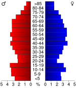
In the county the population was spread out with 22.80% under the age of 18, 6.40% from 18 to 24, 23.70% from 25 to 44, 27.00% from 45 to 64, and 20.20% who were 65 years of age or older. The median age was 43 years. For every 100 females there were 96.00 males. For every 100 females age 18 and over, there were 93.10 males.
The median income for a household in the county was $25,529, and the median income for a family was $29,952. Males had a median income of $22,213 versus $18,066 for females. The per capita income
for the county was $15,712. About 12.70% of families and 16.30% of the population were below the poverty line, including 20.10% of those under age 18 and 12.70% of those age 65 or over.
County (United States)
In the United States, a county is a geographic subdivision of a state , usually assigned some governmental authority. The term "county" is used in 48 of the 50 states; Louisiana is divided into parishes and Alaska into boroughs. Parishes and boroughs are called "county-equivalents" by the U.S...
located in the U.S. state
U.S. state
A U.S. state is any one of the 50 federated states of the United States of America that share sovereignty with the federal government. Because of this shared sovereignty, an American is a citizen both of the federal entity and of his or her state of domicile. Four states use the official title of...
of Arkansas
Arkansas
Arkansas is a state located in the southern region of the United States. Its name is an Algonquian name of the Quapaw Indians. Arkansas shares borders with six states , and its eastern border is largely defined by the Mississippi River...
. As of 2010, the population was 12,245. The county seat
County seat
A county seat is an administrative center, or seat of government, for a county or civil parish. The term is primarily used in the United States....
is Salem
Salem, Fulton County, Arkansas
Salem is a city in Fulton County, Arkansas, United States. As of the 2000 census the population stood at 1,591. Salem was first incorporated in 1900.-Geography:Salem is located at ....
. Fulton County was formed on December 21, 1842, and named for William Fulton
William Savin Fulton
William Savin Fulton was an American lawyer and politician from Little Rock, Arkansas. He served as Governor of the Arkansas Territory and United States Senator for Arkansas....
, the last governor of the Arkansas Territory
Arkansas Territory
The Territory of Arkansas, initially organized as the Territory of Arkansaw, was an organized incorporated territory of the United States that existed from July 4, 1819 until June 15, 1836, when the final extent of the territory was admitted to the Union as the State of Arkansas.-History:The...
. It is an alcohol prohibition or dry county
Dry county
A dry county is a county in the United States whose government forbids the sale of alcoholic beverages. Some prohibit off-premises sale, some prohibit on-premises sale, and some prohibit both. Hundreds of dry counties exist across the United States, almost all of them in the South...
.
Geography
According to the 2000 census, the county has a total area of 620.31 square miles (1,606.6 km²), of which 618.16 square miles (1,601 km²) (or 99.65%) is land and 2.16 square miles (5.6 km²) (or 0.35%) is water.Major highways
- U.S. Highway 62 Business
 Highway 9
 Highway 87
 Highway 175
 Highway 223
- Highway 289
 Highway 395
Adjacent counties
- Ozark CountyOzark County, MissouriOzark County is a county located in South Central Missouri in the United States. As of the 2000 U.S. Census, the county's population was 9,542. A 2008 estimate, however, showed the population to be 9,227. The largest city and county seat is Gainesville. From 1843 to 1845 the county was called...
, MissouriMissouriMissouri is a US state located in the Midwestern United States, bordered by Iowa, Illinois, Kentucky, Tennessee, Arkansas, Oklahoma, Kansas and Nebraska. With a 2010 population of 5,988,927, Missouri is the 18th most populous state in the nation and the fifth most populous in the Midwest. It...
(northwest) - Howell CountyHowell County, MissouriHowell County is a county located in South Central Missouri in the United States. As of the 2010 U.S. Census, the county's population was 40,400. The largest city and county seat is West Plains...
, MissouriMissouriMissouri is a US state located in the Midwestern United States, bordered by Iowa, Illinois, Kentucky, Tennessee, Arkansas, Oklahoma, Kansas and Nebraska. With a 2010 population of 5,988,927, Missouri is the 18th most populous state in the nation and the fifth most populous in the Midwest. It...
(north) - Oregon CountyOregon County, MissouriOregon County is a county located in South Central Missouri in the United States. As of the 2000 U.S. Census, the county's population was 10,344. A 2008 estimate, however, showed the population to be 10,264. Its county seat is Alton...
, MissouriMissouriMissouri is a US state located in the Midwestern United States, bordered by Iowa, Illinois, Kentucky, Tennessee, Arkansas, Oklahoma, Kansas and Nebraska. With a 2010 population of 5,988,927, Missouri is the 18th most populous state in the nation and the fifth most populous in the Midwest. It...
(northeast) - Sharp CountySharp County, Arkansas-External links:*...
(east) - Izard County (south)
- Baxter CountyBaxter County, ArkansasBaxter County is a county located in the U.S. state of Arkansas. It is in the northern part of the state, and shares a border with Missouri. It is commonly referred to as the Twin Lakes Area because it is bordered by two of Arkansas' largest lakes, Bull Shoals Lake and Norfork Lake...
(west)
Demographics
Census
A census is the procedure of systematically acquiring and recording information about the members of a given population. It is a regularly occurring and official count of a particular population. The term is used mostly in connection with national population and housing censuses; other common...
of 2000, there were 11,642 people, 4,810 households, and 3,511 families residing in the county. The population density
Population density
Population density is a measurement of population per unit area or unit volume. It is frequently applied to living organisms, and particularly to humans...
was 19 people per square mile (7/km²). There were 5,973 housing units at an average density of 10 per square mile (4/km²). The racial makeup of the county was 97.67% White
Race (United States Census)
Race and ethnicity in the United States Census, as defined by the Federal Office of Management and Budget and the United States Census Bureau, are self-identification data items in which residents choose the race or races with which they most closely identify, and indicate whether or not they are...
, 0.20% Black
Race (United States Census)
Race and ethnicity in the United States Census, as defined by the Federal Office of Management and Budget and the United States Census Bureau, are self-identification data items in which residents choose the race or races with which they most closely identify, and indicate whether or not they are...
or African American
Race (United States Census)
Race and ethnicity in the United States Census, as defined by the Federal Office of Management and Budget and the United States Census Bureau, are self-identification data items in which residents choose the race or races with which they most closely identify, and indicate whether or not they are...
, 0.67% Native American
Race (United States Census)
Race and ethnicity in the United States Census, as defined by the Federal Office of Management and Budget and the United States Census Bureau, are self-identification data items in which residents choose the race or races with which they most closely identify, and indicate whether or not they are...
, 0.21% Asian
Race (United States Census)
Race and ethnicity in the United States Census, as defined by the Federal Office of Management and Budget and the United States Census Bureau, are self-identification data items in which residents choose the race or races with which they most closely identify, and indicate whether or not they are...
, 0.06% from other races
Race (United States Census)
Race and ethnicity in the United States Census, as defined by the Federal Office of Management and Budget and the United States Census Bureau, are self-identification data items in which residents choose the race or races with which they most closely identify, and indicate whether or not they are...
, and 1.19% from two or more races. 0.53% of the population were Hispanic
Race (United States Census)
Race and ethnicity in the United States Census, as defined by the Federal Office of Management and Budget and the United States Census Bureau, are self-identification data items in which residents choose the race or races with which they most closely identify, and indicate whether or not they are...
or Latino
Race (United States Census)
Race and ethnicity in the United States Census, as defined by the Federal Office of Management and Budget and the United States Census Bureau, are self-identification data items in which residents choose the race or races with which they most closely identify, and indicate whether or not they are...
of any race.
There were 4,810 households out of which 27.40% had children under the age of 18 living with them, 62.40% were married couples
Marriage
Marriage is a social union or legal contract between people that creates kinship. It is an institution in which interpersonal relationships, usually intimate and sexual, are acknowledged in a variety of ways, depending on the culture or subculture in which it is found...
living together, 7.80% had a female householder with no husband present, and 27.00% were non-families. 24.40% of all households were made up of individuals and 12.80% had someone living alone who was 65 years of age or older. The average household size was 2.39 and the average family size was 2.83.
In the county the population was spread out with 22.80% under the age of 18, 6.40% from 18 to 24, 23.70% from 25 to 44, 27.00% from 45 to 64, and 20.20% who were 65 years of age or older. The median age was 43 years. For every 100 females there were 96.00 males. For every 100 females age 18 and over, there were 93.10 males.
The median income for a household in the county was $25,529, and the median income for a family was $29,952. Males had a median income of $22,213 versus $18,066 for females. The per capita income
Per capita income
Per capita income or income per person is a measure of mean income within an economic aggregate, such as a country or city. It is calculated by taking a measure of all sources of income in the aggregate and dividing it by the total population...
for the county was $15,712. About 12.70% of families and 16.30% of the population were below the poverty line, including 20.10% of those under age 18 and 12.70% of those age 65 or over.
Cities and towns
|
Salem, Fulton County, Arkansas Salem is a city in Fulton County, Arkansas, United States. As of the 2000 census the population stood at 1,591. Salem was first incorporated in 1900.-Geography:Salem is located at .... Viola, Arkansas Viola is a town in Fulton County, Arkansas, United States. The population was 381 at the 2000 census.-Geography:Viola is located at .According to the United States Census Bureau, the town has a total area of , all land.-Demographics:... |
Townships
- Afton (part of HardyHardy, ArkansasHardy is a city in Sharp and Fulton counties in the U.S. state of Arkansas. The population was 578 at the 2000 census.-Geography:Hardy is located at .The Spring River, which begins in Mammoth Spring, flows through Hardy...
) - Benton (SalemSalem, ArkansasSalem is the name of four places in the U.S. state of Arkansas:*Salem, Fulton County, Arkansas, a city in northern Arkansas*Salem, Ouachita County, Arkansas*Salem, Pike County, Arkansas...
) - Big Creek
- Cleveland
- Fulton (ViolaViola, ArkansasViola is a town in Fulton County, Arkansas, United States. The population was 381 at the 2000 census.-Geography:Viola is located at .According to the United States Census Bureau, the town has a total area of , all land.-Demographics:...
) - Mammoth Spring (Mammoth SpringMammoth Spring, ArkansasMammoth Spring is a city in Fulton County, Arkansas, United States. The population was 977 at the 2010 census.-Geography:Mammoth Spring is located at ....
) - Mount Calm
- Myatt
- Pleasant Ridge (half of Cherokee VillageCherokee Village, ArkansasCherokee Village is a city in Fulton and Sharp counties in the U.S. state of Arkansas. The population was 4,807 at the 2007 census.-Geography:Cherokee Village is located at ....
, small part of Ash FlatAsh Flat, ArkansasAsh Flat is a city in Fulton and Sharp counties in the U.S. state of Arkansas. The population was 977 at the 2000 census. The city is the county seat of Sharp County.-Geography:Ash Flat is located at ....
) - South Fork
- Strawberry (small part of Horseshoe BendHorseshoe Bend, ArkansasHorseshoe Bend is a city in Fulton, Izard, and Sharp counties in the U.S. state of Arkansas. The population was 2,278 at the 2000 census.-Geography:Horseshoe Bend is located at ....
) - Union
- Vidette
- Washington
- Wilson