
River Cherwell
Encyclopedia
The River Cherwell is a river which flows through the Midlands
of England
. It is a major tributary
of the River Thames
.
The general course of the River Cherwell is north to south and the 'straight-line' distance from its source to the Thames is about 32 miles (51.5 km). It flows from Hellidon
through Northamptonshire
for about ten miles (16 km) before passing into Oxfordshire
for the remainder of its journey to Oxford
, where it joins the Thames. It adds a significant discharge to the Thames—when entering Oxford, the Thames' discharge is 17.6 m³/s (622 cu ft/s), but after leaving and consuming the Cherwell it has increased to 24.8 m³/s (876 cu ft/s).
hills at Hellidon
, two miles (3 km) west of Charwelton
near Daventry
. Helidon Hill immediately north of the source forms a watershed
: on the south side, the Cherwell feeds the River Thames and thence the North Sea at the Thames Estuary
; on the north side, the River Leam
feeds the Warwickshire
River Avon and the River Severn
and thence the Bristol Channel. (A third river system on this watershed rises east of Charwelton and feeds tributary streams of the River Nene
and thence the North Sea at The Wash
.)
South of Charwelton, the River Cherwell passes between the villages of Hinton
and Woodford Halse
. Woodford Halse was much expanded by the building of the Great Central Railway
in 1900.
Two miles further on, the River Cherwell swings westward for a few miles, passing below the village of Chipping Warden
through Edgcote
, site of a Romano-British
villa
. The river passes from Northamptonshire into Oxfordshire at Hay's Bridge on the A361
Daventry to Banbury
road.
, the River Cherwell turns southward again. The Oxford Canal
enters the river valley here and more or less follows the Cherwell on its route to Oxford
until it reaches Thrupp
near Kidlington
. The canal was projected to connect the Coventry Canal
to the River Thames, and the Act of Parliament
authorising it was passed in 1769. A few years earlier, Oxford merchants had proposed 'canal-ising' the River Cherwell upstream from their city to Banbury. Construction of the Oxford Canal began near Coventry
but the canal didn't reach Banbury until 1778, and it was a further twelve years before it was completed, the first boats reaching Oxford in January 1790.
The River Cherwell skirts the east side of Cropredy itself and passes under Cropredy Bridge
, site of a major battle of the English Civil War
in 1644. The battle was a protracted encounter with riverside skirmishes concentrated along a three-mile (5 km) stretch of the River Cherwell between Hay's bridge and a ford at Slat Mill near Great Bourton. King Charles's
forces beat the Parliamentarian
army.
On Cropredy Bridge is a plaque bearing the words "Site of the Battle of Cropredy Bridge 1644. From Civil War deliver us." The bridge was rebuilt in 1780 and this plaque is a facsimile of the original one. Cropredy's church contains relics from the battle, and local tradition holds that local people hid the church's eagle lectern
in the River Cherwell in case marauding soldiers damaged or stole it.
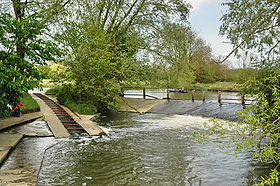
South of Cropredy Bridge, the river skirts the fields used for the annual Cropredy Festival
, a three-day music event run by the band Fairport Convention
. It then passes the site of a former water mill
. A sufficient head of water to power the mill was created by a weir
system and a millpond. There may have been more rudimentary mill works upstream but this is the first major mill along the river's course.
and enters the industrial hinterland of Banbury, passing the site of another water mill. From here, a main line railway runs alongside on the west side. This line was built by the Great Western Railway
and links London
and Oxford with Birmingham
and the north. South of this point, the railway closely follows the Cherwell valley.
The town of Banbury grew up alongside the River Cherwell. A Roman villa at nearby Wykham Park dates from around the year 250 but it was the Saxons who built the first settlement west of the River Cherwell. On the opposite bank is the Saxon settlement of Grimsbury
, now absorbed into Banbury.
Banbury Castle
was built in 1135 on the west bank of the Cherwell commanding the river. The castle was extended and rebuilt many times. In the English civil war the castle became a Royalist
stronghold and was besieged during the winter of 1644–1645. A second siege began in January 1646 and lasted until April when a surrender was negotiated. Following a petition to the House of Commons
in 1648, the castle was demolished.
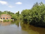
There was a substantial water mill on the River Cherwell near the castle. The brick-built mill building and the miller's cottage have been modernised and extended to serve Banbury as a theatre and arts centre.
on higher ground to the west of the river. Downstream of Banbury, most of the villages in the Cherwell valley are similarly set back from the river on higher ground to avoid flooding.
After Bodicote, the river passes an industrial estate at Twyford Mill before reaching King's Sutton
, a village noted for the splendid lofty spire
on its church which overlooks the river. Two miles further on, the Cherwell reaches the settlement of Nell Bridge and passes under a main road leading to the village of Aynho
which is a mile to the east on a low hill overlooking the river.
Shortly after Nell Bridge, the River Cherwell crosses the Oxford Canal at a right-angle, flowing in on the east side and out over a weir on the west side. Such level river crossings are fairly uncommon on English canals. A few yards below this crossing is Aynho Weir Lock. This lock is unusual in that instead of a rectangular chamber, it has a wide lozenge-shaped chamber. This is because the lock lowers the canal by only 12 inches (304.8 mm) and the extra width of the lock chamber compensates for the smaller amount of water which would otherwise be passed from the River Cherwell to feed the lower level of the canal.
Adjacent to Aynho Weir, the railway route splits. South of this junction, the original line continues down the Cherwell valley to Oxford; east of it, a more direct route (opened in 1910 by the Great Western Railway) runs via Bicester
and High Wycombe
to London
, originally served by trains to Paddington station but now by trains to Marylebone station. On the line to Oxford, the River Cherwell supplied water to the railway, feeding long troughs laid on top of the sleepers between the rails so that locomotives could scoop up water to replenish their tanks without stopping.
and Heyford are the only villages adjacent to the river itself and both once had water mills. The mill at Lower Heyford
was last rebuilt in the early 19th century and worked as a mill as recently as 1946. However, there was a mill here before the Norman Conquest
and this fact is mentioned in the Domesday Book
.
At Rousham
, the River Cherwell passes a famous landscape garden
designed by William Kent
. It features many statues and a temple which overlooks the River Cherwell. The terrace by the river is named the Praeneste after the ancient temple in Palestrina
near Rome
.
Two miles south of Rousham the river is crossed by a medieval packhorse bridge
at Northbrook and a further mile south the course of Akeman Street
, a Roman road
, crosses the river. South of here, the Cherwell valley narrows and becomes more wooded.
The River Cherwell passes under the Woodstock
to Bicester
road and shortly after the Oxford Canal flows into it from the east. The next mile of the river is used by boats as part of the canal route. The canal and river pass a now-derelict cement works which was once supplied by canal narrowboat
s and which used water extracted from the river.
After sharing their course for about one mile (1.6 km), the Oxford Canal and River Cherwell diverge at Shipton Weir Lock (a similar lozenge-shaped structure to the lock at Aynho Weir). To the west of the lock is the village of Shipton on Cherwell. The bridge carrying the railway over the canal was the site of a major train crash in December 1874 in which more than 30 people died (Shipton-on-Cherwell train crash
).
East of Shipton, the deserted village of Hampton Gay
stands on the bank of the River Cherwell. The most substantial remnant is the church which stands in lonely isolation in the watermeadows but there are ruins of a manor house too. Beyond here, the river reaches Thrupp
where the Oxford Canal finally leaves the Cherwell valley.
There was a Romano-British settlement not far from the River Cherwell near Kidlington
and a substantial Romano-British villa across the river at Islip
. To the east of Islip is a wide plain called Otmoor
drained by the River Ray and its small tributaries. The Ray flows into the River Cherwell at the weir in Islip, known as The Stank.
 The River Cherwell reaches the northern outskirts of Oxford
and runs south on the eastern edge of north Oxford town centre. Near Summertown
it passes the Victoria Arms (or "Vicky Arms"), a popular riverside pub at Marston and then under a modern bridge that is part of Marston Ferry Road
. A little further south, the Cherwell passes Wolfson College
(a graduate college of Oxford University), the Cherwell Boathouse
(where punts
can be hired) and the playing fields of the Dragon School
. Next is Lady Margaret Hall
, one of the previously all-women's Oxford colleges.
The river is then flanked by University Parks and passes under Rainbow Bridge
. Parson's Pleasure
and Dame's Delight
used to provide nude bathing facilities for male and female bathers respectively, but both are now defunct. Below the Parks, the river splits into up to three streams, with a series of islands. One is Mesopotamia
, which is a long thin island just south of the Parks with a path that provides a pleasant walk. At the northern end, there are punt rollers next to a weir. St Catherine's College
is on the largest island formed by the split of the river. It also flows past Magdalen College
.
The river conjoins again into two streams close together to flow under Magdalen Bridge. Early on May Morning
, students sometimes jump off the bridge into the river, but this is a dangerous pastime, especially if the river is low. The river splits again past the bridge. To the west is the Oxford Botanic Garden. To the east are Magdalen College School
and St Hilda's College
. The river then skirts Christ Church Meadow
before flowing into the River Thames
(or Isis
) through two branches. On the island in between these branches are many of the college boathouse
s for rowing
on the Thames.
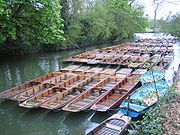
In summer, punt
ing is very popular on the Oxford stretch of the Cherwell. (A punt is a long flat bottom boat which is propelled by means of a pole pushed against the river bed.) Punts are typically hired from a punt station by Magdalen Bridge, or the Cherwell Boathouse
(just to the north of the University Parks
). It is possible to punt all the way from the Isis
, north past the University Parks, and out beyond the ring road
.
The confluence of the Thames and Cherwell was the site of early settlements and the River Cherwell marked the boundary between the Dobunni
tribe to the west and the Catuvellauni
tribe to the east (these were pre-Roman Celt
ic tribes).
A Romano-British settlement grew up north of the confluence, partly because the site was naturally protected from attack on the east by the River Cherwell and on the west by the River Thames. This settlement dominated the pottery trade in what is now central southern England and pottery was distributed by boats on the Thames and its tributaries.
English Midlands
The Midlands, or the English Midlands, is the traditional name for the area comprising central England that broadly corresponds to the early medieval Kingdom of Mercia. It borders Southern England, Northern England, East Anglia and Wales. Its largest city is Birmingham, and it was an important...
of England
England
England is a country that is part of the United Kingdom. It shares land borders with Scotland to the north and Wales to the west; the Irish Sea is to the north west, the Celtic Sea to the south west, with the North Sea to the east and the English Channel to the south separating it from continental...
. It is a major tributary
Tributary
A tributary or affluent is a stream or river that flows into a main stem river or a lake. A tributary does not flow directly into a sea or ocean...
of the River Thames
River Thames
The River Thames flows through southern England. It is the longest river entirely in England and the second longest in the United Kingdom. While it is best known because its lower reaches flow through central London, the river flows alongside several other towns and cities, including Oxford,...
.
The general course of the River Cherwell is north to south and the 'straight-line' distance from its source to the Thames is about 32 miles (51.5 km). It flows from Hellidon
Hellidon
Hellidon is a village and civil parish in the Daventry district of the county of Northamptonshire in England. According to the 2001 census the parish had a population of 180; it reached its highest population, 449, in 1861....
through Northamptonshire
Northamptonshire
Northamptonshire is a landlocked county in the English East Midlands, with a population of 629,676 as at the 2001 census. It has boundaries with the ceremonial counties of Warwickshire to the west, Leicestershire and Rutland to the north, Cambridgeshire to the east, Bedfordshire to the south-east,...
for about ten miles (16 km) before passing into Oxfordshire
Oxfordshire
Oxfordshire is a county in the South East region of England, bordering on Warwickshire and Northamptonshire , Buckinghamshire , Berkshire , Wiltshire and Gloucestershire ....
for the remainder of its journey to Oxford
Oxford
The city of Oxford is the county town of Oxfordshire, England. The city, made prominent by its medieval university, has a population of just under 165,000, with 153,900 living within the district boundary. It lies about 50 miles north-west of London. The rivers Cherwell and Thames run through...
, where it joins the Thames. It adds a significant discharge to the Thames—when entering Oxford, the Thames' discharge is 17.6 m³/s (622 cu ft/s), but after leaving and consuming the Cherwell it has increased to 24.8 m³/s (876 cu ft/s).
Watershed and upper course
The River Cherwell rises in the ironstoneIronstone
Ironstone is a sedimentary rock, either deposited directly as a ferruginous sediment or created by chemical repacement, that contains a substantial proportion of an iron compound from which iron either can be or once was smelted commercially. This term is customarily restricted to hard coarsely...
hills at Hellidon
Hellidon
Hellidon is a village and civil parish in the Daventry district of the county of Northamptonshire in England. According to the 2001 census the parish had a population of 180; it reached its highest population, 449, in 1861....
, two miles (3 km) west of Charwelton
Charwelton
Charwelton is a village and civil parish about south of Daventry in Northamptonshire, England. Its toponym is derived from the River Cherwell beside which the village stands....
near Daventry
Daventry
Daventry is a market town in Northamptonshire, England, with a population of 22,367 .-Geography:The town is also the administrative centre of the larger Daventry district, which has a population of 71,838. The town is 77 miles north-northwest of London, 13.9 miles west of Northampton and 10.2...
. Helidon Hill immediately north of the source forms a watershed
Water divide
A drainage divide, water divide, divide or watershed is the line separating neighbouring drainage basins...
: on the south side, the Cherwell feeds the River Thames and thence the North Sea at the Thames Estuary
Thames Estuary
The Thames Mouth is the estuary in which the River Thames meets the waters of the North Sea.It is not easy to define the limits of the estuary, although physically the head of Sea Reach, near Canvey Island on the Essex shore is probably the western boundary...
; on the north side, the River Leam
River Leam
The River Leam is a river which flows through eastern and southern Warwickshire. It is a small river about 25–30 miles long. The town of Leamington Spa lies on, and is named after, the River Leam....
feeds the Warwickshire
Warwickshire
Warwickshire is a landlocked non-metropolitan county in the West Midlands region of England. The county town is Warwick, although the largest town is Nuneaton. The county is famous for being the birthplace of William Shakespeare...
River Avon and the River Severn
River Severn
The River Severn is the longest river in Great Britain, at about , but the second longest on the British Isles, behind the River Shannon. It rises at an altitude of on Plynlimon, Ceredigion near Llanidloes, Powys, in the Cambrian Mountains of mid Wales...
and thence the Bristol Channel. (A third river system on this watershed rises east of Charwelton and feeds tributary streams of the River Nene
River Nene
The River Nene is a river in the east of England that rises from three sources in the county of Northamptonshire. The tidal river forms the border between Cambridgeshire and Norfolk for about . It is the tenth longest river in the United Kingdom, and is navigable for from Northampton to The...
and thence the North Sea at The Wash
The Wash
The Wash is the square-mouthed bay and estuary on the northwest margin of East Anglia on the east coast of England, where Norfolk meets Lincolnshire. It is among the largest estuaries in the United Kingdom...
.)
South of Charwelton, the River Cherwell passes between the villages of Hinton
Hinton, Northamptonshire
Hinton is a village about south of Daventry in Northamptonshire. The village is the largest settlement in the civil parish of Woodford cum Membris, the others being the village of Woodford Halse and hamlet of West Farndon.-History:...
and Woodford Halse
Woodford Halse
Woodford Halse is a village about south of Daventry in Northamptonshire. It is in the civil parish of Woodford cum Membris, which includes also village of Hinton and hamlet of West Farndon...
. Woodford Halse was much expanded by the building of the Great Central Railway
Great Central Railway
The Great Central Railway was a railway company in England which came into being when the Manchester, Sheffield and Lincolnshire Railway changed its name in 1897 in anticipation of the opening in 1899 of its London Extension . On 1 January 1923, it was grouped into the London and North Eastern...
in 1900.
Two miles further on, the River Cherwell swings westward for a few miles, passing below the village of Chipping Warden
Chipping Warden
Chipping Warden is a village in Northamptonshire, England about northeast of the Oxfordshire town of Banbury. The parish is bounded to the east and south by the River Cherwell, to the west by the boundary with Oxfordshire and to the north by field boundaries....
through Edgcote
Edgcote
Edgcote is a village and civil parish on the River Cherwell in south-west Northamptonshire. The parish is bounded by the river to the north and by one of its tributaries to the east...
, site of a Romano-British
Romano-British
Romano-British culture describes the culture that arose in Britain under the Roman Empire following the Roman conquest of AD 43 and the creation of the province of Britannia. It arose as a fusion of the imported Roman culture with that of the indigenous Britons, a people of Celtic language and...
villa
Villa
A villa was originally an ancient Roman upper-class country house. Since its origins in the Roman villa, the idea and function of a villa have evolved considerably. After the fall of the Roman Republic, villas became small farming compounds, which were increasingly fortified in Late Antiquity,...
. The river passes from Northamptonshire into Oxfordshire at Hay's Bridge on the A361
A361 road
The A361 is a major road in England and at is the longest 3 digit A road in the UK. It runs south from Ilfracombe on the north Devon coast to Barnstaple, turning south-east to Tiverton then, after a break , north east from Taunton in Somerset through Street and Glastonbury, past Frome and then...
Daventry to Banbury
Banbury
Banbury is a market town and civil parish on the River Cherwell in the Cherwell District of Oxfordshire. It is northwest of London, southeast of Birmingham, south of Coventry and north northwest of the county town of Oxford...
road.
Cropredy and the Upper Oxford Canal
Half-a-mile north of the village of CropredyCropredy
Cropredy is a village and civil parish on the River Cherwell, north of Banbury in Oxfordshire.-Early history:The village has Anglo-Saxon origins and is recorded in the Domesday Book...
, the River Cherwell turns southward again. The Oxford Canal
Oxford Canal
The Oxford Canal is a narrow canal in central England linking Oxford with Coventry via Banbury and Rugby. It connects with the River Thames at Oxford, to the Grand Union Canal at the villages of Braunston and Napton-on-the-Hill, and to the Coventry Canal at Hawkesbury Junction in Bedworth just...
enters the river valley here and more or less follows the Cherwell on its route to Oxford
Oxford
The city of Oxford is the county town of Oxfordshire, England. The city, made prominent by its medieval university, has a population of just under 165,000, with 153,900 living within the district boundary. It lies about 50 miles north-west of London. The rivers Cherwell and Thames run through...
until it reaches Thrupp
Thrupp, Oxfordshire
Thrupp is a hamlet just north of Kidlington in Oxfordshire. It is beside the Oxford Canal and close to the River Cherwell.-History:Before the Norman conquest of England in 1066 the manor of Thrupp belonged to Stigand, Archbishop of Canterbury. In 1070 Stigand was deposed and William the Conqueror...
near Kidlington
Kidlington
Kidlington is a large village and civil parish between the River Cherwell and the Oxford Canal, north of Oxford and southwest of Bicester.-History:...
. The canal was projected to connect the Coventry Canal
Coventry Canal
The Coventry Canal is a navigable narrow canal in the Midlands of England.It starts in Coventry and ends 38 miles north at Fradley Junction, just north of Lichfield, where it joins the Trent and Mersey Canal...
to the River Thames, and the Act of Parliament
Act of Parliament
An Act of Parliament is a statute enacted as primary legislation by a national or sub-national parliament. In the Republic of Ireland the term Act of the Oireachtas is used, and in the United States the term Act of Congress is used.In Commonwealth countries, the term is used both in a narrow...
authorising it was passed in 1769. A few years earlier, Oxford merchants had proposed 'canal-ising' the River Cherwell upstream from their city to Banbury. Construction of the Oxford Canal began near Coventry
Coventry
Coventry is a city and metropolitan borough in the county of West Midlands in England. Coventry is the 9th largest city in England and the 11th largest in the United Kingdom. It is also the second largest city in the English Midlands, after Birmingham, with a population of 300,848, although...
but the canal didn't reach Banbury until 1778, and it was a further twelve years before it was completed, the first boats reaching Oxford in January 1790.
The River Cherwell skirts the east side of Cropredy itself and passes under Cropredy Bridge
Cropredy Bridge
Cropredy Bridge was first built in 1312 and carries a road into a village of the same name beside the upper reaches of the River Cherwell at Cropredy in Oxfordshire, England...
, site of a major battle of the English Civil War
English Civil War
The English Civil War was a series of armed conflicts and political machinations between Parliamentarians and Royalists...
in 1644. The battle was a protracted encounter with riverside skirmishes concentrated along a three-mile (5 km) stretch of the River Cherwell between Hay's bridge and a ford at Slat Mill near Great Bourton. King Charles's
Charles I of England
Charles I was King of England, King of Scotland, and King of Ireland from 27 March 1625 until his execution in 1649. Charles engaged in a struggle for power with the Parliament of England, attempting to obtain royal revenue whilst Parliament sought to curb his Royal prerogative which Charles...
forces beat the Parliamentarian
Roundhead
"Roundhead" was the nickname given to the supporters of the Parliament during the English Civil War. Also known as Parliamentarians, they fought against King Charles I and his supporters, the Cavaliers , who claimed absolute power and the divine right of kings...
army.
On Cropredy Bridge is a plaque bearing the words "Site of the Battle of Cropredy Bridge 1644. From Civil War deliver us." The bridge was rebuilt in 1780 and this plaque is a facsimile of the original one. Cropredy's church contains relics from the battle, and local tradition holds that local people hid the church's eagle lectern
Pulpit
Pulpit is a speakers' stand in a church. In many Christian churches, there are two speakers' stands at the front of the church. Typically, the one on the left is called the pulpit...
in the River Cherwell in case marauding soldiers damaged or stole it.
South of Cropredy Bridge, the river skirts the fields used for the annual Cropredy Festival
Cropredy Festival
Fairport's Cropredy Convention is an annual festival of folk and rock music held on the edge of the village of Cropredy in Oxfordshire, England. It has taken place in August since 1976....
, a three-day music event run by the band Fairport Convention
Fairport Convention
Fairport Convention are an English folk rock and later electric folk band, formed in 1967 who are still recording and touring today. They are widely regarded as the most important single group in the English folk rock movement...
. It then passes the site of a former water mill
Watermill
A watermill is a structure that uses a water wheel or turbine to drive a mechanical process such as flour, lumber or textile production, or metal shaping .- History :...
. A sufficient head of water to power the mill was created by a weir
Weir
A weir is a small overflow dam used to alter the flow characteristics of a river or stream. In most cases weirs take the form of a barrier across the river that causes water to pool behind the structure , but allows water to flow over the top...
system and a millpond. There may have been more rudimentary mill works upstream but this is the first major mill along the river's course.
Banbury
After a few miles the River Cherwell passes under the M40 motorwayM40 motorway
The M40 motorway is a motorway in the British transport network that forms a major part of the connection between London and Birmingham. Part of this road forms a section of the unsigned European route E05...
and enters the industrial hinterland of Banbury, passing the site of another water mill. From here, a main line railway runs alongside on the west side. This line was built by the Great Western Railway
Great Western Railway
The Great Western Railway was a British railway company that linked London with the south-west and west of England and most of Wales. It was founded in 1833, received its enabling Act of Parliament in 1835 and ran its first trains in 1838...
and links London
London
London is the capital city of :England and the :United Kingdom, the largest metropolitan area in the United Kingdom, and the largest urban zone in the European Union by most measures. Located on the River Thames, London has been a major settlement for two millennia, its history going back to its...
and Oxford with Birmingham
Birmingham
Birmingham is a city and metropolitan borough in the West Midlands of England. It is the most populous British city outside the capital London, with a population of 1,036,900 , and lies at the heart of the West Midlands conurbation, the second most populous urban area in the United Kingdom with a...
and the north. South of this point, the railway closely follows the Cherwell valley.
The town of Banbury grew up alongside the River Cherwell. A Roman villa at nearby Wykham Park dates from around the year 250 but it was the Saxons who built the first settlement west of the River Cherwell. On the opposite bank is the Saxon settlement of Grimsbury
Grimsbury
Grimsbury is a largely residential area forming the eastern part of Banbury, Oxfordshire, England. It is east of the River Cherwell, the Oxford Canal and the Cherwell Valley Line railway.-History:...
, now absorbed into Banbury.
Banbury Castle
Banbury Castle
Banbury Castle was a medieval castle that stood near the centre of the town of Banbury, Oxfordshire. Historian John Kenyon notes that the castle is "remarkable for its early concentric shape".-History:...
was built in 1135 on the west bank of the Cherwell commanding the river. The castle was extended and rebuilt many times. In the English civil war the castle became a Royalist
Cavalier
Cavalier was the name used by Parliamentarians for a Royalist supporter of King Charles I and son Charles II during the English Civil War, the Interregnum, and the Restoration...
stronghold and was besieged during the winter of 1644–1645. A second siege began in January 1646 and lasted until April when a surrender was negotiated. Following a petition to the House of Commons
British House of Commons
The House of Commons is the lower house of the Parliament of the United Kingdom, which also comprises the Sovereign and the House of Lords . Both Commons and Lords meet in the Palace of Westminster. The Commons is a democratically elected body, consisting of 650 members , who are known as Members...
in 1648, the castle was demolished.
There was a substantial water mill on the River Cherwell near the castle. The brick-built mill building and the miller's cottage have been modernised and extended to serve Banbury as a theatre and arts centre.
South of Banbury
South of Banbury, the valley of the River Cherwell widens out. On the west bank is a large housing estate built in the 1970s named Cherwell Heights and a mile south the ancient village of BodicoteBodicote
Bodicote is a village and civil parish south of the centre of Banbury in Oxfordshire.-History:A windmill that stood next to the grove at the top of Bodicote is mentioned in the Domesday Book of AD 1086...
on higher ground to the west of the river. Downstream of Banbury, most of the villages in the Cherwell valley are similarly set back from the river on higher ground to avoid flooding.
After Bodicote, the river passes an industrial estate at Twyford Mill before reaching King's Sutton
King's Sutton
King's Sutton is a village and civil parish in South Northamptonshire, England in the valley of the River Cherwell. The village is about south-east of Banbury, Oxfordshire...
, a village noted for the splendid lofty spire
Spire
A spire is a tapering conical or pyramidal structure on the top of a building, particularly a church tower. Etymologically, the word is derived from the Old English word spir, meaning a sprout, shoot, or stalk of grass....
on its church which overlooks the river. Two miles further on, the Cherwell reaches the settlement of Nell Bridge and passes under a main road leading to the village of Aynho
Aynho
Aynho is a village and civil parish in South Northamptonshire, England, on the edge of the Cherwell valley about southeast of the north Oxfordshire town of Banbury and southwest of Brackley...
which is a mile to the east on a low hill overlooking the river.
Shortly after Nell Bridge, the River Cherwell crosses the Oxford Canal at a right-angle, flowing in on the east side and out over a weir on the west side. Such level river crossings are fairly uncommon on English canals. A few yards below this crossing is Aynho Weir Lock. This lock is unusual in that instead of a rectangular chamber, it has a wide lozenge-shaped chamber. This is because the lock lowers the canal by only 12 inches (304.8 mm) and the extra width of the lock chamber compensates for the smaller amount of water which would otherwise be passed from the River Cherwell to feed the lower level of the canal.
Adjacent to Aynho Weir, the railway route splits. South of this junction, the original line continues down the Cherwell valley to Oxford; east of it, a more direct route (opened in 1910 by the Great Western Railway) runs via Bicester
Bicester
Bicester is a town and civil parish in the Cherwell district of northeastern Oxfordshire in England.This historic market centre is one of the fastest growing towns in Oxfordshire Development has been favoured by its proximity to junction 9 of the M40 motorway linking it to London, Birmingham and...
and High Wycombe
High Wycombe
High Wycombe , commonly known as Wycombe and formally called Chepping Wycombe or Chipping Wycombe until 1946,is a large town in Buckinghamshire, England. It is west-north-west of Charing Cross in London; this figure is engraved on the Corn Market building in the centre of the town...
to London
London
London is the capital city of :England and the :United Kingdom, the largest metropolitan area in the United Kingdom, and the largest urban zone in the European Union by most measures. Located on the River Thames, London has been a major settlement for two millennia, its history going back to its...
, originally served by trains to Paddington station but now by trains to Marylebone station. On the line to Oxford, the River Cherwell supplied water to the railway, feeding long troughs laid on top of the sleepers between the rails so that locomotives could scoop up water to replenish their tanks without stopping.
Lower course, Somerton, Heyford, Rousham and Shipton
From Aynho, the River Cherwell meanders in its valley overlooked by hilltop villages. SomertonSomerton, Oxfordshire
Somerton is a village and civil parish in Oxfordshire, England, in the Cherwell valley about northwest of Bicester.-Early history:More than a dozen Saxon or early Mediaeval graves have been discovered in the yard of Somerton's former Free School....
and Heyford are the only villages adjacent to the river itself and both once had water mills. The mill at Lower Heyford
Lower Heyford
Lower Heyford is a village and civil parish in Oxfordshire, beside the River Cherwell about west of Bicester.-Prehistory:Aves ditch is pre-Anglo-Saxon and may have been dug as a boundary ditch...
was last rebuilt in the early 19th century and worked as a mill as recently as 1946. However, there was a mill here before the Norman Conquest
Norman conquest of England
The Norman conquest of England began on 28 September 1066 with the invasion of England by William, Duke of Normandy. William became known as William the Conqueror after his victory at the Battle of Hastings on 14 October 1066, defeating King Harold II of England...
and this fact is mentioned in the Domesday Book
Domesday Book
Domesday Book , now held at The National Archives, Kew, Richmond upon Thames in South West London, is the record of the great survey of much of England and parts of Wales completed in 1086...
.
At Rousham
Rousham House
Rousham House is a Jacobean country house at Rousham in Oxfordshire, England. The house has been in the ownership of one family since it was built.-History:...
, the River Cherwell passes a famous landscape garden
Landscape garden
The term landscape garden is often used to describe the English garden design style characteristic of the eighteenth century, that swept the Continent replacing the formal Renaissance garden and Garden à la française models. The work of Lancelot 'Capability' Brown is particularly influential.The...
designed by William Kent
William Kent
William Kent , born in Bridlington, Yorkshire, was an eminent English architect, landscape architect and furniture designer of the early 18th century.He was baptised as William Cant.-Education:...
. It features many statues and a temple which overlooks the River Cherwell. The terrace by the river is named the Praeneste after the ancient temple in Palestrina
Palestrina
Palestrina is an ancient city and comune with a population of about 18,000, in Lazio, c. 35 km east of Rome...
near Rome
Rome
Rome is the capital of Italy and the country's largest and most populated city and comune, with over 2.7 million residents in . The city is located in the central-western portion of the Italian Peninsula, on the Tiber River within the Lazio region of Italy.Rome's history spans two and a half...
.
Two miles south of Rousham the river is crossed by a medieval packhorse bridge
Packhorse bridge
A packhorse bridge is a bridge intended to carry packhorses across a river or stream. Typically a packhorse bridge consists of one or more narrow masonry arches, and has low parapets so as not to interfere with the horse's panniers.Packhorse bridges were often built on the trade routes that...
at Northbrook and a further mile south the course of Akeman Street
Akeman Street
Akeman Street was a major Roman road in England that linked Watling Street with the Fosse Way. Its junction with Watling Steet was just north of Verulamium and that with the Fosse Way was at Corinium Dobunnorum...
, a Roman road
Roman road
The Roman roads were a vital part of the development of the Roman state, from about 500 BC through the expansion during the Roman Republic and the Roman Empire. Roman roads enabled the Romans to move armies and trade goods and to communicate. The Roman road system spanned more than 400,000 km...
, crosses the river. South of here, the Cherwell valley narrows and becomes more wooded.
The River Cherwell passes under the Woodstock
Woodstock, Oxfordshire
Woodstock is a small town northwest of Oxford in Oxfordshire, England. It is the location of Blenheim Palace, a UNESCO World Heritage Site.Winston Churchill was born in Blenheim Palace in 1874 and is buried in the nearby village of Bladon....
to Bicester
Bicester
Bicester is a town and civil parish in the Cherwell district of northeastern Oxfordshire in England.This historic market centre is one of the fastest growing towns in Oxfordshire Development has been favoured by its proximity to junction 9 of the M40 motorway linking it to London, Birmingham and...
road and shortly after the Oxford Canal flows into it from the east. The next mile of the river is used by boats as part of the canal route. The canal and river pass a now-derelict cement works which was once supplied by canal narrowboat
Narrowboat
A narrowboat or narrow boat is a boat of a distinctive design, made to fit the narrow canals of Great Britain.In the context of British Inland Waterways, "narrow boat" refers to the original working boats built in the 18th, 19th, and 20th centuries for carrying goods on the narrow canals...
s and which used water extracted from the river.
After sharing their course for about one mile (1.6 km), the Oxford Canal and River Cherwell diverge at Shipton Weir Lock (a similar lozenge-shaped structure to the lock at Aynho Weir). To the west of the lock is the village of Shipton on Cherwell. The bridge carrying the railway over the canal was the site of a major train crash in December 1874 in which more than 30 people died (Shipton-on-Cherwell train crash
Shipton-on-Cherwell train crash
The Shipton-on-Cherwell train crash was a major disaster which occurred on the Great Western Railway. It involved the derailment of a long passenger train at Shipton-on-Cherwell near Kidlington, Oxfordshire, England, on Christmas Eve, 24 December 1874, and was one of the worst ever disasters on...
).
East of Shipton, the deserted village of Hampton Gay
Hampton Gay
Hampton Gay is a village in the Cherwell valley about north of Kidlington, Oxfordshire.-Manor:After the Norman Conquest of England Robert D'Oyly gave an estate of three hides at Hampton Gay to his brother in arms Roger d'Ivry, while a second estate of two hides at Hampton Gay belonged to the...
stands on the bank of the River Cherwell. The most substantial remnant is the church which stands in lonely isolation in the watermeadows but there are ruins of a manor house too. Beyond here, the river reaches Thrupp
Thrupp, Oxfordshire
Thrupp is a hamlet just north of Kidlington in Oxfordshire. It is beside the Oxford Canal and close to the River Cherwell.-History:Before the Norman conquest of England in 1066 the manor of Thrupp belonged to Stigand, Archbishop of Canterbury. In 1070 Stigand was deposed and William the Conqueror...
where the Oxford Canal finally leaves the Cherwell valley.
There was a Romano-British settlement not far from the River Cherwell near Kidlington
Kidlington
Kidlington is a large village and civil parish between the River Cherwell and the Oxford Canal, north of Oxford and southwest of Bicester.-History:...
and a substantial Romano-British villa across the river at Islip
Islip, Oxfordshire
Islip is a village and civil parish on the River Ray, just above its confluence with the River Cherwell in Oxfordshire, England. It is about east of Kidlington and about north of Oxford. This village in Oxfordshire is not related to Islip, New York...
. To the east of Islip is a wide plain called Otmoor
Otmoor
Otmoor or Ot Moor is an area of wetland and wet grassland in Oxfordshire, England, located halfway between Oxford and Bicester. It is about above sea level, and has an area of approximately ....
drained by the River Ray and its small tributaries. The Ray flows into the River Cherwell at the weir in Islip, known as The Stank.
The city of Oxford
Oxford
The city of Oxford is the county town of Oxfordshire, England. The city, made prominent by its medieval university, has a population of just under 165,000, with 153,900 living within the district boundary. It lies about 50 miles north-west of London. The rivers Cherwell and Thames run through...
and runs south on the eastern edge of north Oxford town centre. Near Summertown
Summertown, Oxford
Summertown in North Oxford is a suburb of Oxford, England.Summertown is a residential area, one mile square north of St Giles, the beautiful boulevard leading out of Oxford’s city centre. Summertown is home to exclusive schools and the city’s most expensive houses. On both sides of Banbury Road are...
it passes the Victoria Arms (or "Vicky Arms"), a popular riverside pub at Marston and then under a modern bridge that is part of Marston Ferry Road
Marston Ferry Road
Marston Ferry Road is a link road in north Oxford, England.The road links the Banbury Road in North Oxford just south of Summertown with Cherwell Drive in Marston, continuing as Headley Way to Headington to the southeast. It is a modern link road with a bridge over the River Cherwell about half way...
. A little further south, the Cherwell passes Wolfson College
Wolfson College, Oxford
Wolfson College is a constituent college of the University of Oxford in England. Located in north Oxford along the River Cherwell, Wolfson is an all-graduate college with over sixty governing body fellows, in addition to both research and junior research fellows. It caters to a wide range of...
(a graduate college of Oxford University), the Cherwell Boathouse
Cherwell Boathouse
The Cherwell Boathouse is a boathouse on the River Cherwell in Oxford, England. It is located down a small lane off the junction between Chadlington Road and Bardwell Road, which itself is off the Banbury Road in North Oxford....
(where punts
Punt (boat)
A punt is a flat-bottomed boat with a square-cut bow, designed for use in small rivers or other shallow water. Punting refers to boating in a punt. The punter generally propels the punt by pushing against the river bed with a pole...
can be hired) and the playing fields of the Dragon School
Dragon School
The Dragon School is a British coeducational, preparatory school in the city of Oxford, founded in 1877 as the Oxford Preparatory School, or OPS. It is primarily known as a boarding school, although it also takes day pupils...
. Next is Lady Margaret Hall
Lady Margaret Hall, Oxford
Lady Margaret Hall is one of the constituent colleges of the University of Oxford in England, located at the end of Norham Gardens in north Oxford. As of 2006 the college had an estimated financial endowment of £34m....
, one of the previously all-women's Oxford colleges.
The river is then flanked by University Parks and passes under Rainbow Bridge
Rainbow Bridge, Oxford
Rainbow Bridge is a curved footbridge over the River Cherwell in the University Parks, Oxford, England. The bridge is made of concrete with metal railings, in the shape of a rainbow, hence the name...
. Parson's Pleasure
Parson's Pleasure
Parson's Pleasure in the University Parks at Oxford, England, was a secluded area for male-only nude bathing on the River Cherwell. It was located next to the path on the way to Mesopotamia at the south-east corner of the Parks...
and Dame's Delight
Dame's Delight
Dame's Delight was a place for women to bathe in the nude on the bank of the River Cherwell in the meadows near the Oxford University Parks opposite Mesopotamia Walk in Oxford, England. It was started in 1934, but closed in 1970 due to maintenance difficulties because of flooding.A similar bathing...
used to provide nude bathing facilities for male and female bathers respectively, but both are now defunct. Below the Parks, the river splits into up to three streams, with a series of islands. One is Mesopotamia
Mesopotamia, Oxford
Mesopotamia is a narrow island that forms part of the University Parks, Oxford, England. It lies between the upper and lower levels of the River Cherwell...
, which is a long thin island just south of the Parks with a path that provides a pleasant walk. At the northern end, there are punt rollers next to a weir. St Catherine's College
St Catherine's College, Oxford
St Catherine's College, often called Catz, is one of the constituent colleges of the University of Oxford in England. Its motto is Nova et Vetera...
is on the largest island formed by the split of the river. It also flows past Magdalen College
Magdalen College, Oxford
Magdalen College is one of the constituent colleges of the University of Oxford in England. As of 2006 the college had an estimated financial endowment of £153 million. Magdalen is currently top of the Norrington Table after over half of its 2010 finalists received first-class degrees, a record...
.
The river conjoins again into two streams close together to flow under Magdalen Bridge. Early on May Morning
May Morning
May Morning is an annual event in Oxford, England, on May Day . It starts early at 6am with the Magdalen College Choir singing a hymn, the Hymnus Eucharisticus, from the top of Magdalen Tower, a tradition of over 500 years. Large crowds normally gather under the tower along the High Street and on...
, students sometimes jump off the bridge into the river, but this is a dangerous pastime, especially if the river is low. The river splits again past the bridge. To the west is the Oxford Botanic Garden. To the east are Magdalen College School
Magdalen College School, Oxford
Magdalen College School is an independent school for boys aged 7 to 18 and girls in the sixth form, located on The Plain in Oxford, England. It was founded as part of Magdalen College, Oxford by William Waynflete in 1480....
and St Hilda's College
St Hilda's College, Oxford
St Hilda's College is one of the constituent colleges of the University of Oxford in England.The college was founded in 1893 as a hall for women, and remained an all-women's college until 2006....
. The river then skirts Christ Church Meadow
Christ Church Meadow, Oxford
Christ Church Meadow is a famous flood-meadow, and popular walking and picnic spot in Oxford, England.Roughly triangular in shape it is bounded by the River Thames , the River Cherwell, and Christ Church. It provides access to many of the college boat houses which are on an island at the confluence...
before flowing into the River Thames
River Thames
The River Thames flows through southern England. It is the longest river entirely in England and the second longest in the United Kingdom. While it is best known because its lower reaches flow through central London, the river flows alongside several other towns and cities, including Oxford,...
(or Isis
The Isis
The Isis is the name given to the part of the River Thames above Iffley Lock which flows through the city of Oxford. The name is especially used in the context of rowing at the University of Oxford...
) through two branches. On the island in between these branches are many of the college boathouse
Boathouse
A boathouse is a building especially designed for the storage of boats, normally smaller craft for sports or leisure use. These are typically located on open water, such as on a river. Often the boats stored are rowing boats...
s for rowing
Sport rowing
Rowing is a sport in which athletes race against each other on rivers, on lakes or on the ocean, depending upon the type of race and the discipline. The boats are propelled by the reaction forces on the oar blades as they are pushed against the water...
on the Thames.
In summer, punt
Punt (boat)
A punt is a flat-bottomed boat with a square-cut bow, designed for use in small rivers or other shallow water. Punting refers to boating in a punt. The punter generally propels the punt by pushing against the river bed with a pole...
ing is very popular on the Oxford stretch of the Cherwell. (A punt is a long flat bottom boat which is propelled by means of a pole pushed against the river bed.) Punts are typically hired from a punt station by Magdalen Bridge, or the Cherwell Boathouse
Cherwell Boathouse
The Cherwell Boathouse is a boathouse on the River Cherwell in Oxford, England. It is located down a small lane off the junction between Chadlington Road and Bardwell Road, which itself is off the Banbury Road in North Oxford....
(just to the north of the University Parks
University Parks
The Oxford University Parks, more normally the University Parks, or just The Parks to members of the local community, is one large parkland area slightly northeast of the Oxford city centre in England...
). It is possible to punt all the way from the Isis
The Isis
The Isis is the name given to the part of the River Thames above Iffley Lock which flows through the city of Oxford. The name is especially used in the context of rowing at the University of Oxford...
, north past the University Parks, and out beyond the ring road
Oxford Ring Road
The Oxford ring road is a ring road around the city of Oxford, England. It is a dual carriageway for most of its length apart from a short section to the North between the Woodstock and Banbury Roads....
.
The confluence of the Thames and Cherwell was the site of early settlements and the River Cherwell marked the boundary between the Dobunni
Dobunni
The Dobunni were one of the Celtic tribes living in the British Isles prior to the Roman invasion of Britain. There are seven known references to the tribe in Roman histories and inscriptions. The latter part of the name possibly derives from Bune, a cup or vessel...
tribe to the west and the Catuvellauni
Catuvellauni
The Catuvellauni were a tribe or state of south-eastern Britain before the Roman conquest.The fortunes of the Catuvellauni and their kings before the conquest can be traced through numismatic evidence and scattered references in classical histories. They are mentioned by Dio Cassius, who implies...
tribe to the east (these were pre-Roman Celt
Celt
The Celts were a diverse group of tribal societies in Iron Age and Roman-era Europe who spoke Celtic languages.The earliest archaeological culture commonly accepted as Celtic, or rather Proto-Celtic, was the central European Hallstatt culture , named for the rich grave finds in Hallstatt, Austria....
ic tribes).
A Romano-British settlement grew up north of the confluence, partly because the site was naturally protected from attack on the east by the River Cherwell and on the west by the River Thames. This settlement dominated the pottery trade in what is now central southern England and pottery was distributed by boats on the Thames and its tributaries.