
The Wash
Encyclopedia
Estuary
An estuary is a partly enclosed coastal body of water with one or more rivers or streams flowing into it, and with a free connection to the open sea....
on the northwest margin of East Anglia
East Anglia
East Anglia is a traditional name for a region of eastern England, named after an ancient Anglo-Saxon kingdom, the Kingdom of the East Angles. The Angles took their name from their homeland Angeln, in northern Germany. East Anglia initially consisted of Norfolk and Suffolk, but upon the marriage of...
on the east coast of England, where Norfolk meets Lincolnshire
Lincolnshire
Lincolnshire is a county in the east of England. It borders Norfolk to the south east, Cambridgeshire to the south, Rutland to the south west, Leicestershire and Nottinghamshire to the west, South Yorkshire to the north west, and the East Riding of Yorkshire to the north. It also borders...
. It is among the largest estuaries in the United Kingdom
United Kingdom
The United Kingdom of Great Britain and Northern IrelandIn the United Kingdom and Dependencies, other languages have been officially recognised as legitimate autochthonous languages under the European Charter for Regional or Minority Languages...
. It is fed by the Rivers Witham
River Witham
The River Witham is a river, almost entirely in the county of Lincolnshire, in the east of England. It rises south of Grantham close to South Witham, at SK8818, passes Lincoln at SK9771 and at Boston, TF3244, flows into The Haven, a tidal arm of The Wash, near RSPB Frampton Marsh...
, Welland
River Welland
The River Welland is a river in the east of England, some long. It rises in the Hothorpe Hills, at Sibbertoft in Northamptonshire, then flows generally northeast to Market Harborough, Stamford and Spalding, to reach The Wash near Fosdyke. For much of its length it forms the county boundary between...
, Nene
River Nene
The River Nene is a river in the east of England that rises from three sources in the county of Northamptonshire. The tidal river forms the border between Cambridgeshire and Norfolk for about . It is the tenth longest river in the United Kingdom, and is navigable for from Northampton to The...
and Great Ouse.
Geography
East Anglia
East Anglia is a traditional name for a region of eastern England, named after an ancient Anglo-Saxon kingdom, the Kingdom of the East Angles. The Angles took their name from their homeland Angeln, in northern Germany. East Anglia initially consisted of Norfolk and Suffolk, but upon the marriage of...
from Lincolnshire
Lincolnshire
Lincolnshire is a county in the east of England. It borders Norfolk to the south east, Cambridgeshire to the south, Rutland to the south west, Leicestershire and Nottinghamshire to the west, South Yorkshire to the north west, and the East Riding of Yorkshire to the north. It also borders...
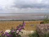
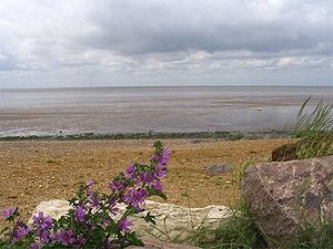
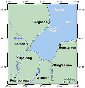
. It is formed by a large bay with three roughly straight sides meeting at right angles, each about 15 miles (25 km) in length. The eastern coast of the Wash is entirely within Norfolk
Norfolk
Norfolk is a low-lying county in the East of England. It has borders with Lincolnshire to the west, Cambridgeshire to the west and southwest and Suffolk to the south. Its northern and eastern boundaries are the North Sea coast and to the north-west the county is bordered by The Wash. The county...
, and extends from a point a little north of Hunstanton
Hunstanton
Hunstanton, often pronounced by locals as and known colloquially as 'Sunny Hunny', is a seaside town in Norfolk, England, facing The Wash....
in the north to the mouth of the River Great Ouse
River Great Ouse
The Great Ouse is a river in the east of England. At long, it is the fourth-longest river in the United Kingdom. The river has been important for navigation, and for draining the low-lying region through which it flows. Its course has been modified several times, with the first recorded being in...
at King's Lynn
King's Lynn
King's Lynn is a sea port and market town in the ceremonial county of Norfolk in the East of England. It is situated north of London and west of Norwich. The population of the town is 42,800....
in the south. The opposing coast, which is roughly parallel to the east coast, runs from Gibraltar Point
Gibraltar Point
Gibraltar Point National Nature Reserve is an area of approximately in Lincolnshire, England.The reserve is owned by Lincolnshire County Council and East Lindsey District Council and is administered by the Lincolnshire Wildlife Trust...
to the mouth of the River Welland
River Welland
The River Welland is a river in the east of England, some long. It rises in the Hothorpe Hills, at Sibbertoft in Northamptonshire, then flows generally northeast to Market Harborough, Stamford and Spalding, to reach The Wash near Fosdyke. For much of its length it forms the county boundary between...
, all within Lincolnshire. The southern coast runs roughly northwest-southeast, connects these two river mouths and is punctuated by the mouth of a third river, the River Nene
River Nene
The River Nene is a river in the east of England that rises from three sources in the county of Northamptonshire. The tidal river forms the border between Cambridgeshire and Norfolk for about . It is the tenth longest river in the United Kingdom, and is navigable for from Northampton to The...
.
Inland from the Wash the land is flat, low-lying and often marshy: these are the Fens
The Fens
The Fens, also known as the , are a naturally marshy region in eastern England. Most of the fens were drained several centuries ago, resulting in a flat, damp, low-lying agricultural region....
of Lincolnshire
Lincolnshire
Lincolnshire is a county in the east of England. It borders Norfolk to the south east, Cambridgeshire to the south, Rutland to the south west, Leicestershire and Nottinghamshire to the west, South Yorkshire to the north west, and the East Riding of Yorkshire to the north. It also borders...
, Cambridgeshire
Cambridgeshire
Cambridgeshire is a county in England, bordering Lincolnshire to the north, Norfolk to the northeast, Suffolk to the east, Essex and Hertfordshire to the south, and Bedfordshire and Northamptonshire to the west...
and Norfolk
Norfolk
Norfolk is a low-lying county in the East of England. It has borders with Lincolnshire to the west, Cambridgeshire to the west and southwest and Suffolk to the south. Its northern and eastern boundaries are the North Sea coast and to the north-west the county is bordered by The Wash. The county...
.
Owing to deposits of sediment and land reclamation
Land reclamation
Land reclamation, usually known as reclamation, is the process to create new land from sea or riverbeds. The land reclaimed is known as reclamation ground or landfill.- Habitation :...
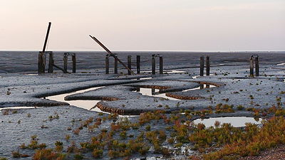
, the coastline of the Wash has altered markedly within historical times; several towns once on the coast of the Wash (notably King's Lynn) are now some distance inland. Much of the Wash itself is very shallow, with several large sandbanks—such as Breast Sand, Bulldog Sand, Roger Sand and Old South Sand—exposed at low tide, especially along its south coast. For this reason, navigation in the Wash can be hazardous for boats. A lightship
Lightvessel
A lightvessel, or lightship, is a ship which acts as a lighthouse. They are used in waters that are too deep or otherwise unsuitable for lighthouse construction...
marks the entrance to the Lynn Channel
King's Lynn
King's Lynn is a sea port and market town in the ceremonial county of Norfolk in the East of England. It is situated north of London and west of Norwich. The population of the town is 42,800....
, the one safe channel from the North Sea
North Sea
In the southwest, beyond the Straits of Dover, the North Sea becomes the English Channel connecting to the Atlantic Ocean. In the east, it connects to the Baltic Sea via the Skagerrak and Kattegat, narrow straits that separate Denmark from Norway and Sweden respectively...
to the Wash's south coast.
Water temperature
The Wash varies enormously in water temperature throughout the year. Winter temperatures are brought near freezing from the cold North Sea flows. Summer water temperatures can reach into the low 20s degrees C (about 70 degrees F) after prolonged high ambient air temperature and sun. This effect, which typically happens in the shallow areas around beaches, and often only in pockets of water, is exaggerated by the large sheltered tidal reach.Wash River
At the end of the latest glaciationWisconsin glaciation
The last glacial period was the most recent glacial period within the current ice age occurring during the last years of the Pleistocene, from approximately 110,000 to 10,000 years ago....
, and while the sea level remained lower than it is today, the rivers Witham
River Witham
The River Witham is a river, almost entirely in the county of Lincolnshire, in the east of England. It rises south of Grantham close to South Witham, at SK8818, passes Lincoln at SK9771 and at Boston, TF3244, flows into The Haven, a tidal arm of The Wash, near RSPB Frampton Marsh...
, Welland
River Welland
The River Welland is a river in the east of England, some long. It rises in the Hothorpe Hills, at Sibbertoft in Northamptonshire, then flows generally northeast to Market Harborough, Stamford and Spalding, to reach The Wash near Fosdyke. For much of its length it forms the county boundary between...
, Glen
River Glen, Lincolnshire
The River Glen is a river in Lincolnshire, England with a short stretch passing through Rutland near Essendine.The river's name appears to derive from a Brythonic Celtic language but there is a strong early English connection.-Naming:...
, Nene
River Nene
The River Nene is a river in the east of England that rises from three sources in the county of Northamptonshire. The tidal river forms the border between Cambridgeshire and Norfolk for about . It is the tenth longest river in the United Kingdom, and is navigable for from Northampton to The...
and Great Ouse joined into a large river.
The deep valley of the Wash was formed, not by the interglacial river, but by ice of the Wolstonian and Devensian
Wisconsin glaciation
The last glacial period was the most recent glacial period within the current ice age occurring during the last years of the Pleistocene, from approximately 110,000 to 10,000 years ago....
stages flowing southwards up the slope represented by the modern coast and forming tunnel valley
Tunnel valley
A tunnel valley is a large, long, U-shaped valley originally cut under the glacial ice near the margin of continental ice sheets such as that now covering Antarctica and formerly covering portions of all continents during past glacial ages....
s of which the Silver Pit
Silver Pit
Also notable is the Silverpit crater, a crater-like feature near the Silver Pit, discovered in 2002.-Origin of the Silver Pit:In origin, it is probably a tunnel valley which was kept free of periglacial deposits by the Wash River when the sea level was lower, towards the end of the Devensian...
is one of many. It was this process which gave the Silver Pit its depth and narrowness. When the tunnel valley was free of ice and seawater, it was occupied by the river. This kept it free of sediment, unlike most of the tunnel valleys. Since the sea flooded it, the valley seems to have been kept open by tidal action. During the Ipswichian Stage, though the Wash River probably flowed by way of the site of the Silver Pit, the tunnel valley will not have been formed at this stage as its alignment seems inconsistent.
Wildlife
The Wash is a Special Protection AreaSpecial Protection Area
A Special Protection Area or SPA is a designation under the European Union Directive on the Conservation of Wild Birds.Under the Directive, Member States of the European Union have a duty to safeguard the habitats of migratory birds and certain particularly threatened birds.Together with Special...
(SPA) under European Union
European Union
The European Union is an economic and political union of 27 independent member states which are located primarily in Europe. The EU traces its origins from the European Coal and Steel Community and the European Economic Community , formed by six countries in 1958...
legislation. It is made up of very extensive salt marsh
Salt marsh
A salt marsh is an environment in the upper coastal intertidal zone between land and salt water or brackish water, it is dominated by dense stands of halophytic plants such as herbs, grasses, or low shrubs. These plants are terrestrial in origin and are essential to the stability of the salt marsh...
es, major intertidal banks of sand and mud, shallow waters and deep channels. The seawall at Freiston
Freiston
Freiston is a village and civil parish in Lincolnshire, England, about east of Boston.It is one of 18 civil parishes which, together with Boston, form the Borough of Boston local government arrangement, in place since a reorganisation of 1 April 1974 which resulted from the Local...
has been breached in three places to increase the saltmarsh area, to provide an extra habitat
Habitat (ecology)
A habitat is an ecological or environmental area that is inhabited by a particular species of animal, plant or other type of organism...
for bird
Bird
Birds are feathered, winged, bipedal, endothermic , egg-laying, vertebrate animals. Around 10,000 living species and 188 families makes them the most speciose class of tetrapod vertebrates. They inhabit ecosystems across the globe, from the Arctic to the Antarctic. Extant birds range in size from...
s, particularly wader
Wader
Waders, called shorebirds in North America , are members of the order Charadriiformes, excluding the more marine web-footed seabird groups. The latter are the skuas , gulls , terns , skimmers , and auks...
s, and also as a natural flood prevention measure. The extensive creeks in the salt marsh, and the vegetation that grows there, helps dissipate wave energy thus improving the protection afforded to land behind the saltmarsh. This last aspect is an example of the recently developing exploration of the possibilities of sustainable coastal management
Coastal management
In some jurisdictions the terms sea defense and coastal protection are used to mean, respectively, defense against flooding and erosion...
by adopting soft engineering
Soft engineering
In civil engineering of shorelines, soft engineering is the use of ecological principles and practices to reduce erosion and achieve the stabilization and safety of shorelines and the area surrounding rivers, while enhancing habitat, improving aesthetics, and saving money...
techniques. The same scheme includes new brackish
Brackish water
Brackish water is water that has more salinity than fresh water, but not as much as seawater. It may result from mixing of seawater with fresh water, as in estuaries, or it may occur in brackish fossil aquifers. The word comes from the Middle Dutch root "brak," meaning "salty"...
lagoon
Lagoon
A lagoon is a body of shallow sea water or brackish water separated from the sea by some form of barrier. The EU's habitat directive defines lagoons as "expanses of shallow coastal salt water, of varying salinity or water volume, wholly or partially separated from the sea by sand banks or shingle,...
habitat.
Chalk
Chalk is a soft, white, porous sedimentary rock, a form of limestone composed of the mineral calcite. Calcite is calcium carbonate or CaCO3. It forms under reasonably deep marine conditions from the gradual accumulation of minute calcite plates shed from micro-organisms called coccolithophores....
cliff
Cliff
In geography and geology, a cliff is a significant vertical, or near vertical, rock exposure. Cliffs are formed as erosion landforms due to the processes of erosion and weathering that produce them. Cliffs are common on coasts, in mountainous areas, escarpments and along rivers. Cliffs are usually...
s with their famous stratum of red chalk, at Hunstanton, and gravel
Gravel
Gravel is composed of unconsolidated rock fragments that have a general particle size range and include size classes from granule- to boulder-sized fragments. Gravel can be sub-categorized into granule and cobble...
pits (lagoons) at Snettisham RSPB reserve, which are an important roost for waders at high tide. This SPA borders onto the North Norfolk Coast Special Protection Area.
To the northwest, the Wash extends to Gibraltar Point, another Special Protection Area.
The partially confined nature of the Wash habitats, combined with the ample tidal flows, allows shellfish
Shellfish
Shellfish is a culinary and fisheries term for exoskeleton-bearing aquatic invertebrates used as food, including various species of molluscs, crustaceans, and echinoderms. Although most kinds of shellfish are harvested from saltwater environments, some kinds are found only in freshwater...
to breed, especially shrimp
Shrimp
Shrimp are swimming, decapod crustaceans classified in the infraorder Caridea, found widely around the world in both fresh and salt water. Adult shrimp are filter feeding benthic animals living close to the bottom. They can live in schools and can swim rapidly backwards. Shrimp are an important...
, cockle
Cockle (bivalve)
Cockle is the common name for a group of small, edible, saltwater clams, marine bivalve molluscs in the family Cardiidae.Various species of cockles live in sandy sheltered beaches throughout the world....
s and mussel
Mussel
The common name mussel is used for members of several families of clams or bivalvia mollusca, from saltwater and freshwater habitats. These groups have in common a shell whose outline is elongated and asymmetrical compared with other edible clams, which are often more or less rounded or oval.The...
s. Some water birds, e.g. oystercatchers, feed on shellfish. It is also an important breeding area for common tern
Common Tern
The Common Tern is a seabird of the tern family Sternidae. This bird has a circumpolar distribution, breeding in temperate and sub-Arctic regions of Europe, Asia and east and central North America. It is strongly migratory, wintering in coastal tropical and subtropical regions. It is sometimes...
s, and a feeding area for marsh harriers
Western Marsh Harrier
The Western Marsh-harrier is a mid-sized harrier, a bird of prey from temperate and subtropical western Eurasia and adjacent Africa. It is also known as the Eurasian Marsh-harrier....
. Migrating birds, such as geese
Goose
The word goose is the English name for a group of waterfowl, belonging to the family Anatidae. This family also includes swans, most of which are larger than true geese, and ducks, which are smaller....
, duck
Duck
Duck is the common name for a large number of species in the Anatidae family of birds, which also includes swans and geese. The ducks are divided among several subfamilies in the Anatidae family; they do not represent a monophyletic group but a form taxon, since swans and geese are not considered...
s and wading birds, come to the Wash in huge numbers to spend the winter, with an average total of around 400,000 birds present at any one time. It has been estimated that around two million birds will use the Wash for feeding and roosting during their annual migrations.
The Wash is recognised as being Internationally Important for 17 species of bird. This includes pink-footed goose
Pink-footed Goose
The Pink-footed Goose is a goose which breeds in eastern Greenland, Iceland and Svalbard. It is migratory, wintering in northwest Europe, especially Great Britain, the Netherlands, and western Denmark...
, dark-bellied brent goose
Brent Goose
The Brant or Brent Goose, Branta bernicla, is a species of goose of the genus Branta. The Black Brant is an American subspecies. The specific descriptor bernicla is from the same source as "barnacle" in Barnacle Goose, which looks similar but is not a close relation.-Appearance:The Brant Goose is...
, shelduck
Common Shelduck
The Common Shelduck is a waterfowl species shelduck genus Tadorna. It is widespread and common in Eurasia, mainly breeding in temperate and wintering in subtropical regions; in winter, it can also be found in the Maghreb...
, pintail
Northern Pintail
The Pintail or Northern Pintail is a widely occurring duck which breeds in the northern areas of Europe, Asia and North America. It is strongly migratory and winters south of its breeding range to the equator...
, oystercatcher
Eurasian Oystercatcher
The Eurasian Oystercatcher Haematopus ostralegus, also known as the Common Pied Oystercatcher, or just Oystercatcher, is a wader in the oystercatcher bird family Haematopodidae. It is the most widespread of the oystercatchers, with three races breeding in western Europe, central Eurasia,...
, ringed plover
Ringed Plover
The Common Ringed Plover or Ringed Plover is a small plover.Adults are 17-19.5 cm in length with a 35–41 cm wingspan. They have a grey-brown back and wings, a white belly, and a white breast with one black neckband. They have a brown cap, a white forehead, a black mask around the eyes...
, grey plover
Grey Plover
The Grey Plover , known as the Black-bellied Plover in North America, is a medium-sized plover breeding in arctic regions. It is a long-distance migrant, with a nearly worldwide coastal distribution when not breeding....
, golden plover
Eurasian Golden Plover
The European Golden Plover is a largish plover. This species is similar to two other golden plovers. American Golden Plover, Pluvialis dominiica, and Pacific Golden Plover, Pluvialis fulva, are both smaller, slimmer and relatively longer-legged than European Golden Plover, and both have grey...
, lapwing
Northern Lapwing
The Northern Lapwing , also known as the Peewit, Green Plover or just Lapwing, is a bird in the plover family. It is common through temperate Eurasia....
, knot
Red Knot
The Red Knot, Calidris canutus , is a medium sized shorebird which breeds in tundra and the Arctic Cordillera in the far north of Canada, Europe, and Russia. It is a large member of the Calidris sandpipers, second only to the Great Knot...
, sanderling
Sanderling
The Sanderling is a small wader. It is a circumpolar Arctic breeder, and is a long-distance migrant, wintering south to South America, South Europe, Africa, and Australia...
, dunlin
Dunlin
The Dunlin, Calidris alpina, is a small wader, sometimes separated with the other "stints" in Erolia. It is a circumpolar breeder in Arctic or subarctic regions. Birds that breed in northern Europe and Asia are long-distance migrants, wintering south to Africa, southeast Asia and the Middle East...
, black-tailed godwit
Black-tailed Godwit
The Black-tailed Godwit, Limosa limosa, is a large, long-legged, long-billed shorebird first described by Carolus Linnaeus in 1758. It is a member of the Limosa genus, the godwits...
, bar-tailed godwit
Bar-tailed Godwit
The Bar-tailed Godwit is a large wader in the family Scolopacidae, which breeds on Arctic coasts and tundra mainly in the Old World, and winters on coasts in temperate and tropical regions of the Old World...
, curlew
Eurasian Curlew
The Eurasian Curlew, Numenius arquata, is a wader in the large family Scolopacidae. It is one of the most widespread of the curlews, breeding across temperate Europe and Asia...
, redshank
Common Redshank
The Common Redshank or simply Redshank is an Eurasian wader in the large family Scolopacidae.- Description and systematics :...
and turnstone
Turnstone
Turnstones are the bird species in the genus Arenaria in the family Scolopacidae. They are closely related to calidrid sandpipers and might be considered members of the tribe Calidriini....
.
It was featured on the television programme Seven Natural Wonders
Seven Natural Wonders
Seven Natural Wonders was a television series that was broadcast on BBC Two from 3 May to 20 June 2005. The programme took an area of England each week and, from votes by the people living in that area, showed the 'seven natural wonders' of that area in a programme.The programmes were:The series...
as one of the wonders of Yorkshire and Lincolnshire.
King John losing the Crown Jewels
The most famous incident associated with the Wash is King JohnJohn of England
John , also known as John Lackland , was King of England from 6 April 1199 until his death...
losing the Crown Jewels
Crown Jewels of the United Kingdom
The collective term Crown Jewels denotes the regalia and vestments worn by the sovereign of the United Kingdom during the coronation ceremony and at other state functions...
. According to contemporary reports, John travelled from Spalding
Spalding, Lincolnshire
Spalding is a market town with a population of 30,000 on the River Welland in the South Holland district of Lincolnshire, England. Little London is a hamlet directly south of Spalding on the B1172 road....
in Lincolnshire to Bishop's Lynn
King's Lynn
King's Lynn is a sea port and market town in the ceremonial county of Norfolk in the East of England. It is situated north of London and west of Norwich. The population of the town is 42,800....
, in Norfolk, was taken ill and decided to return. While he took the longer route by way of Wisbech
Wisbech
Wisbech is a market town, inland port and civil parish with a population of 20,200 in the Fens of Cambridgeshire. The tidal River Nene runs through the centre of the town and is spanned by two bridges...
, he sent his baggage train, including his crown jewels, along the causeway and ford across the mouth of the Wellstream. This route was usable only on the lower part of the tide. The horse-drawn wagons moved too slowly for the incoming tide, and many were lost.
The present-day location of the accident is normally supposed to be somewhere near Sutton Bridge
Sutton Bridge
Sutton Bridge is a village and civil parish in southeastern Lincolnshire, England on the west bank of the River Nene in the district of South Holland.-Geography:...
, on the River Nene
River Nene
The River Nene is a river in the east of England that rises from three sources in the county of Northamptonshire. The tidal river forms the border between Cambridgeshire and Norfolk for about . It is the tenth longest river in the United Kingdom, and is navigable for from Northampton to The...
. The name of the river changed as a result of redirection of the Great Ouse during the 17th century and Bishop's Lynn became King's Lynn as a result of Henry VIII
Henry VIII of England
Henry VIII was King of England from 21 April 1509 until his death. He was Lord, and later King, of Ireland, as well as continuing the nominal claim by the English monarchs to the Kingdom of France...
's rearrangement of the English Church
Church of England
The Church of England is the officially established Christian church in England and the Mother Church of the worldwide Anglican Communion. The church considers itself within the tradition of Western Christianity and dates its formal establishment principally to the mission to England by St...
.
Astronomical study, however, permits a reconstruction of the tide tables of the relevant day and it seems most likely, given travel in the usual daylight hours, that the loss was incurred in crossing the Welland Estuary
River Welland
The River Welland is a river in the east of England, some long. It rises in the Hothorpe Hills, at Sibbertoft in Northamptonshire, then flows generally northeast to Market Harborough, Stamford and Spalding, to reach The Wash near Fosdyke. For much of its length it forms the county boundary between...
at Fosdyke
Fosdyke
Fosdyke is a village and civil parish in Lincolnshire, England. It lies about south of Boston just off the A17, and east from the junction of the A17 with the A16. The village is near the mouth of the River Welland, and the parish extends across the river to include both ends of the hamlet of...
.
There is also a suspicion that John left his jewels in Lynn as security for a loan and arranged for their "loss." This looks likely to be apocryphal. However that may be, he passed the following night, that of the 12th to 13 October 1216, at Swineshead Abbey
Swineshead, Lincolnshire
Not to be confused with Swineshead, BedfordshireSwineshead is a village and civil parish in Lincolnshire, England, around miles west of the town of Boston...
, moved on to Newark-on-Trent
Newark-on-Trent
Newark-on-Trent is a market town in Nottinghamshire in the East Midlands region of England. It stands on the River Trent, the A1 , and the East Coast Main Line railway. The origins of the town are possibly Roman as it lies on an important Roman road, the Fosse Way...
and died of his illness on 19 October.
Local traditions
Sailing from out of the South Lincolnshire Fens into the Wash (especially with respect to shell-fishing) is traditionally known locally as "Going Down Below".Although still used today, the origin of the phrase is unknown, and is generally an oral tradition without documentary evidence.
This phrase is however also used in Newfoundland, particularly the Bonavista area. It is used to refer to going down to sea level, mainly a beach or water mark.
Landmark
The Boston Stump, a Lincolnshire landmark, can on clearer days be seen from the Norfolk side of the Wash. The Outer Trial BankOuter Trial Bank
The Outer Trial Bank is a circular artificial island in the Wash, East Anglia, England. It is one of two islands constructed during the 1970s for a governmental water resources scheme.- Background :...
, a remnant of a 1970s government experiment, lies approximately 2 miles (3.2 km) off the Lincolnshire coast near the River Nene
River Nene
The River Nene is a river in the east of England that rises from three sources in the county of Northamptonshire. The tidal river forms the border between Cambridgeshire and Norfolk for about . It is the tenth longest river in the United Kingdom, and is navigable for from Northampton to The...
.