
Downtown Portland
Encyclopedia
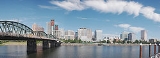
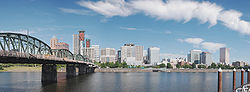
Downtown Portland, the city center of Portland, Oregon
, United States
, is located on the west bank of the Willamette River
. It is in the northeastern corner of the southwest section of the city and is where most of the city's high-rise
buildings are found.
The downtown area is usually considered to extend west from the Willamette to Interstate 405
, and south from Union Station
to just south of the Portland State University
campus (also bounded by I-405). (The northeastern portion of this area is also part of the Old Town Chinatown
neighborhood.) High-density business and residential districts near downtown include the Lloyd District, across the river from the northern part of downtown, and the South Waterfront
area, currently in development just south of downtown in the South Portland neighborhood.
Portland's downtown is unique in that at its founding, streets were made narrow (64 ft [20 m] wide) and blocks were made square and compact, 200 feet (61 m) on a side, to encourage easy walking and make more (relatively valuable) corner lots. (By comparison, Seattle
's blocks are 240 by 320 ft (73.2 by 97.5 m), and Manhattan
's east-west streets are divided into blocks that are from 600–800 ft (182.9–243.8 m) long.) The 264 feet (80 m) long combined blocks divide one mile (1.6 km) of road into exactly 20 separate blocks.
Unlike many downtown revitalization efforts around the United States at this time, Portland's plan did not call for widespread demolition and reconstruction. In the early 1970s, Portland's central city was beginning to decay, with the creation of suburban shopping malls in the neighboring cities of Beaverton
, Tigard
, and Gresham
drawing away money and people from downtown. However, the creation of a downtown transit mall in 1977 (see Transportation, below), a new waterfront park
in 1978 (later named after Governor Tom McCall
), the creation of the Pioneer Courthouse Square
in 1984, the opening of the Portland–Gresham light rail line in 1986, and the opening of Pioneer Place
mall in 1990 successfully drew or retained businesses and lured customers. The downtown, which had been a virtual ghost town
after 6 PM, is now a vibrant all-hours shopping, dining, and business venue.
This apparent success due to Portland's policies has not been without criticisms. Some charge that the transit mall and increased pedestrian traffic has attracted transient and homeless persons from around the city, and aggressive panhandling has increased, despite periodic police crackdowns. Others argue that a proposed expansion of the transit mall is an unneeded expense, and that parking and traffic problems in the downtown area are an indication of the failure of Portland's transit policies to address growth-related problems. Downtown also has an inordinate number of surface level parking lots which contradict the city's efforts to promote higher density and create the critical mass of storefronts needed for a vibrant downtown. Some changes are being made slowly, such as the creation of the Smart Park garage system, and conversion of a surface-level parking lot into a park with underground parking at Park Block 5 between the Fox Tower and Park Avenue West Tower
.
s entering downtown and immediately adjacent areas. The bridges are (south to north):
There are two other road bridges within Portland across the Willamette—but they're outside the downtown area. See List of crossings of the Willamette River.
and the Cascade Range
.
Downtown is also served by several forms of public transportation. Because of its shorter blocks, walking
is often preferred by the locals. TriMet
, the regional mass transit agency, operates MAX light rail on two alignments in downtown, one running east/west on Yamhill and Morrison streets and north/south on 1st Avenue, the other running north/south on 5th and 6th avenues. On the latter two streets, an extensive transit mall
—known as the Portland Mall
—limits private vehicles and provides connections between more than fifty bus lines, MAX light rail, and the Portland Streetcar
.
The southern part of downtown and the West End are also served by the Portland Streetcar system, operating from South Waterfront north into the Pearl and Northwest Portland districts. The system is currently a single route, measuring 3.9 miles (6.3 km) end to end, and connects in South Waterfront with the Tram (aerial cableway)
to Oregon Health & Science University
(OHSU).
All of downtown lies within Portland's Free Rail Zone (known as "Fareless Square" from 1975–2010), a zone in which rides on light rail and streetcars are free. The Free Rail Zone's boundaries are the I-405 freeway
(the zone's west and south boundary), the Willamette River
and NW Irving Street, plus a panhandle-shaped section outside of downtown, encompassing the MAX stations from the Rose Quarter
to Lloyd Center
. Until January 2010, rides on buses were also free within this zone.
While not located in the downtown area, another notable building is the Oregon Convention Center
, the largest convention center
in the Pacific Northwest
, which draws many people across the river to downtown.
Portland, Oregon
Portland is a city located in the Pacific Northwest, near the confluence of the Willamette and Columbia rivers in the U.S. state of Oregon. As of the 2010 Census, it had a population of 583,776, making it the 29th most populous city in the United States...
, United States
United States
The United States of America is a federal constitutional republic comprising fifty states and a federal district...
, is located on the west bank of the Willamette River
Willamette River
The Willamette River is a major tributary of the Columbia River, accounting for 12 to 15 percent of the Columbia's flow. The Willamette's main stem is long, lying entirely in northwestern Oregon in the United States...
. It is in the northeastern corner of the southwest section of the city and is where most of the city's high-rise
Skyscraper
A skyscraper is a tall, continuously habitable building of many stories, often designed for office and commercial use. There is no official definition or height above which a building may be classified as a skyscraper...
buildings are found.
The downtown area is usually considered to extend west from the Willamette to Interstate 405
Interstate 405 (Oregon)
Interstate 405 is a short Interstate Highway in Portland, Oregon. It forms a loop from Interstate 5 that travels through downtown Portland west of the Willamette River.-Route description:...
, and south from Union Station
Union Station (Portland)
Union Station is a train station near the west shore of the Willamette River in the Old Town Chinatown section of Portland, Oregon, United States....
to just south of the Portland State University
Portland State University
Portland State University is a public state urban university located in downtown Portland, Oregon, United States. Founded in 1946, it has the largest overall enrollment of any university in the state of Oregon, including undergraduate and graduate students. It is also the only public university in...
campus (also bounded by I-405). (The northeastern portion of this area is also part of the Old Town Chinatown
Old Town Chinatown, Portland, Oregon
Old Town Chinatown is a neighborhood in the Northwest section of Portland, Oregon. The Willamette River forms its eastern boundary, separating it from the Lloyd District and the Kerns and Buckman neighborhoods...
neighborhood.) High-density business and residential districts near downtown include the Lloyd District, across the river from the northern part of downtown, and the South Waterfront
South Waterfront
The South Waterfront is a high-rise district under construction on former brownfield industrial land in the South Portland neighborhood south of downtown Portland, Oregon, U.S. It is one of the largest urban redevelopment projects in the United States...
area, currently in development just south of downtown in the South Portland neighborhood.
Portland's downtown is unique in that at its founding, streets were made narrow (64 ft [20 m] wide) and blocks were made square and compact, 200 feet (61 m) on a side, to encourage easy walking and make more (relatively valuable) corner lots. (By comparison, Seattle
Seattle, Washington
Seattle is the county seat of King County, Washington. With 608,660 residents as of the 2010 Census, Seattle is the largest city in the Northwestern United States. The Seattle metropolitan area of about 3.4 million inhabitants is the 15th largest metropolitan area in the country...
's blocks are 240 by 320 ft (73.2 by 97.5 m), and Manhattan
Manhattan
Manhattan is the oldest and the most densely populated of the five boroughs of New York City. Located primarily on the island of Manhattan at the mouth of the Hudson River, the boundaries of the borough are identical to those of New York County, an original county of the state of New York...
's east-west streets are divided into blocks that are from 600–800 ft (182.9–243.8 m) long.) The 264 feet (80 m) long combined blocks divide one mile (1.6 km) of road into exactly 20 separate blocks.
Urban development
Unlike many downtown revitalization efforts around the United States at this time, Portland's plan did not call for widespread demolition and reconstruction. In the early 1970s, Portland's central city was beginning to decay, with the creation of suburban shopping malls in the neighboring cities of Beaverton
Beaverton, Oregon
Beaverton is a city in Washington County, Oregon, United States, seven miles west of Portland in the Tualatin River Valley.As of the 2010 census, the population is 90,267. This makes it the second-largest city in the county and Oregon's sixth-largest city...
, Tigard
Tigard, Oregon
Tigard is a city in Washington County, Oregon, United States. The population was 48,035 at the 2010 census. As of 2007, Tigard was the state's 12th largest city. Incorporated in 1961, the city is located south of Beaverton and north of Tualatin, and is part of the Portland metropolitan area...
, and Gresham
Gresham, Oregon
- Demographics :As of the census of 2000, there were 90,205 people, 33,327 households, and 22,695 families residing in the city. The population density was 4,071.6 people per square mile . There were 35,309 housing units at an average density of 1,593.8 per square mile...
drawing away money and people from downtown. However, the creation of a downtown transit mall in 1977 (see Transportation, below), a new waterfront park
Tom McCall Waterfront Park
Governor Tom McCall Waterfront Park is a park located on the west bank of the Willamette River in downtown Portland, Oregon. It is , comprising 16 tax lots owned by the City of Portland....
in 1978 (later named after Governor Tom McCall
Tom McCall
Thomas Lawson McCall was an American politician and journalist in the state of Oregon. A Republican, he was the 30th Governor of Oregon from 1967 to 1975. A native of Massachusetts, he grew up there and in Central Oregon before attending the University of Oregon...
), the creation of the Pioneer Courthouse Square
Pioneer Courthouse Square
Pioneer Courthouse Square, affectionately known as Portland's living room, is a public space occupying a full 40,000 ft² city block in the center of downtown Portland, Oregon, United States...
in 1984, the opening of the Portland–Gresham light rail line in 1986, and the opening of Pioneer Place
Pioneer Place
Pioneer Place is an upscale, urban shopping mall in downtown Portland, Oregon. It consists of four blocks of retail, dining, parking, and an office tower named Pioneer Tower. The mall itself is spread out between four buildings, interconnected by skywalks or underground mall sections...
mall in 1990 successfully drew or retained businesses and lured customers. The downtown, which had been a virtual ghost town
Ghost town
A ghost town is an abandoned town or city. A town often becomes a ghost town because the economic activity that supported it has failed, or due to natural or human-caused disasters such as floods, government actions, uncontrolled lawlessness, war, or nuclear disasters...
after 6 PM, is now a vibrant all-hours shopping, dining, and business venue.
This apparent success due to Portland's policies has not been without criticisms. Some charge that the transit mall and increased pedestrian traffic has attracted transient and homeless persons from around the city, and aggressive panhandling has increased, despite periodic police crackdowns. Others argue that a proposed expansion of the transit mall is an unneeded expense, and that parking and traffic problems in the downtown area are an indication of the failure of Portland's transit policies to address growth-related problems. Downtown also has an inordinate number of surface level parking lots which contradict the city's efforts to promote higher density and create the critical mass of storefronts needed for a vibrant downtown. Some changes are being made slowly, such as the creation of the Smart Park garage system, and conversion of a surface-level parking lot into a park with underground parking at Park Block 5 between the Fox Tower and Park Avenue West Tower
Park Avenue West Tower
Park Avenue West, nicknamed PAW, is a high-rise building currently under construction in downtown Portland, Oregon, United States. When completed it will stand at a height of 476 feet and become the third tallest building in Portland behind the Wells Fargo Center and the US Bancorp Tower.Park...
.
Bridges
Portland is sometimes known as "Bridgetown," due to the number of bridges that cross its two rivers. There are eight bridgeBridge
A bridge is a structure built to span physical obstacles such as a body of water, valley, or road, for the purpose of providing passage over the obstacle...
s entering downtown and immediately adjacent areas. The bridges are (south to north):
- Ross Island BridgeRoss Island BridgeThe Ross Island Bridge is a cantilever truss bridge that spans the Willamette River in Portland, Oregon. It carries U.S. Route 26 across the river between southwest and southeast Portland...
, which connects U.S. Route 26U.S. Route 26U.S. Route 26 is an east–west United States highway. It started in Ogallala, Nebraska, and gradually grew to reach the West Coast in Oregon. When the U.S. highway system was first defined, it was limited to Nebraska and Wyoming; by the 1950s, it continued into Idaho and Oregon. The...
(SE Powell Blvd.) to the South WaterfrontSouth WaterfrontThe South Waterfront is a high-rise district under construction on former brownfield industrial land in the South Portland neighborhood south of downtown Portland, Oregon, U.S. It is one of the largest urban redevelopment projects in the United States...
district high-rises - Marquam Bridge, a two-deck bridge carrying I-5 across the Willamette River
- Hawthorne BridgeHawthorne BridgeThe Hawthorne Bridge is a truss bridge with a vertical lift that spans the Willamette River in Portland, Oregon, joining Hawthorne Boulevard and Madison Street. It is the oldest vertical-lift bridge in operation in the United States and the oldest highway bridge in Portland...
, the city's oldest highway bridge and Oregon's most heavily used bridge for bicycles, leading directly into the central business districtCentral business districtA central business district is the commercial and often geographic heart of a city. In North America this part of a city is commonly referred to as "downtown" or "city center"...
(CBD) from the east side - Morrison BridgeMorrison BridgeThe Morrison Bridge is a bascule bridge that spans the Willamette River in Portland, Oregon.The original Morrison Bridge was a wooden truss swing span bridge completed on April 12, 1887 as the first Willamette River bridge in Portland and the longest bridge west of the Mississippi River...
, leading directly into the CBD from the east side - Burnside BridgeBurnside BridgeThe Burnside Bridge is a bascule bridge that spans the Willamette River in Portland, Oregon.-Design:Including approaches, the Burnside has a total length of and a center span. While lowered this span is normally above the river. The deck is made of concrete, which contributes to its being one of...
, connecting the east side to downtown and the Old Town Chinatown neighborhood - Steel BridgeSteel BridgeThe Steel Bridge is a through truss, double lift bridge across the Willamette River in Portland, Oregon, United States. Its lower deck carries railroad and bicycle/pedestrian traffic, while the upper deck carries road traffic and light rail , making the bridge one of the most multimodal in the world...
, the only double-deck bridge with independent lifts in the world, and carrying MAX Light Rail and AmtrakAmtrakThe National Railroad Passenger Corporation, doing business as Amtrak , is a government-owned corporation that was organized on May 1, 1971, to provide intercity passenger train service in the United States. "Amtrak" is a portmanteau of the words "America" and "track". It is headquartered at Union...
into Old Town Chinatown - Broadway BridgeBroadway Bridge (Portland)The Broadway Bridge is a bascule bridge that spans the Willamette River in Portland, Oregon, U.S. It was the first bascule bridge built in Portland and the longest in the world at the time of its completion. It is the longest Rall-type bascule bridge still in existence.-History and description:The...
, connecting the Lloyd DistrictLloyd District, Portland, OregonThe Lloyd District is a primarily commercial neighborhood in the North and Northeast sections of Portland, Oregon. It is named after Ralph Lloyd , a California rancher, oilman, and real estate developer who moved to and started the development of the area.The Lloyd District is bounded by the...
to Old Town Chinatown - Fremont Bridge, carrying I-405 past the PearlPearl District, Portland, OregonThe Pearl District is an area of Portland, Oregon, formerly occupied by warehouses, light industry and railroad classification yards and now noted for its art galleries, upscale businesses and residences. The area has been undergoing significant urban renewal since the late 1990s, including the...
and Northwest districts and into downtown
There are two other road bridges within Portland across the Willamette—but they're outside the downtown area. See List of crossings of the Willamette River.
Transportation
Most streets in downtown Portland are one-way. Naito Parkway (two-way, formerly known as Front Avenue) is the farthest east, while most of the high-rises end by I-405 to the west. Interstate 5 runs on the opposite bank of the river, crossing over on the Marquam Bridge. U.S. Route 26 connects downtown Portland to the Oregon CoastOregon Coast
The Oregon Coast is a region of the U.S. state of Oregon. It runs generally north-south along the Pacific Ocean, forming the western border of the state; the region is bounded to the east by the Oregon Coast Range. The Oregon Coast stretches approximately from the Columbia River in the north to...
and the Cascade Range
Cascade Range
The Cascade Range is a major mountain range of western North America, extending from southern British Columbia through Washington and Oregon to Northern California. It includes both non-volcanic mountains, such as the North Cascades, and the notable volcanoes known as the High Cascades...
.
Downtown is also served by several forms of public transportation. Because of its shorter blocks, walking
Walking
Walking is one of the main gaits of locomotion among legged animals, and is typically slower than running and other gaits. Walking is defined by an 'inverted pendulum' gait in which the body vaults over the stiff limb or limbs with each step...
is often preferred by the locals. TriMet
TriMet
TriMet, more formally known as the Tri-County Metropolitan Transportation District of Oregon, is a public agency that operates mass transit in a region that spans most of the Portland metropolitan area in the U.S. state of Oregon...
, the regional mass transit agency, operates MAX light rail on two alignments in downtown, one running east/west on Yamhill and Morrison streets and north/south on 1st Avenue, the other running north/south on 5th and 6th avenues. On the latter two streets, an extensive transit mall
Transit mall
A transit mall is a street, or set of streets, in a city or town along which automobile traffic is prohibited or greatly restricted and only public transit vehicles, bicycles and pedestrians are permitted....
—known as the Portland Mall
Portland Transit Mall
The Portland Transit Mall is a set of public transit corridors through the center of downtown Portland, Oregon, United States. More specifically, it is a pair of one-way streets—one for northbound traffic, the other for southbound—along which two of the three lanes are restricted to...
—limits private vehicles and provides connections between more than fifty bus lines, MAX light rail, and the Portland Streetcar
Portland Streetcar
The Portland Streetcar is a streetcar system in Portland, Oregon, that opened in 2001 and serves areas surrounding downtown Portland. It is currently a single line that is almost long and serves some 12,000 daily riders, but a second line is expected to open in 2012.As with the heavier-duty MAX...
.
The southern part of downtown and the West End are also served by the Portland Streetcar system, operating from South Waterfront north into the Pearl and Northwest Portland districts. The system is currently a single route, measuring 3.9 miles (6.3 km) end to end, and connects in South Waterfront with the Tram (aerial cableway)
Portland Aerial Tram
The Portland Aerial Tram is an aerial tramway in Portland, Oregon, carrying commuters between the city's South Waterfront district and the main Oregon Health & Science University campus, located in the Marquam Hill neighborhood. It is the second commuter aerial tramway in the United States...
to Oregon Health & Science University
Oregon Health & Science University
Oregon Health & Science University is a public university in Oregon with a main campus, including two hospitals, in Portland and a smaller campus in Hillsboro...
(OHSU).
All of downtown lies within Portland's Free Rail Zone (known as "Fareless Square" from 1975–2010), a zone in which rides on light rail and streetcars are free. The Free Rail Zone's boundaries are the I-405 freeway
Interstate 405 (Oregon)
Interstate 405 is a short Interstate Highway in Portland, Oregon. It forms a loop from Interstate 5 that travels through downtown Portland west of the Willamette River.-Route description:...
(the zone's west and south boundary), the Willamette River
Willamette River
The Willamette River is a major tributary of the Columbia River, accounting for 12 to 15 percent of the Columbia's flow. The Willamette's main stem is long, lying entirely in northwestern Oregon in the United States...
and NW Irving Street, plus a panhandle-shaped section outside of downtown, encompassing the MAX stations from the Rose Quarter
Rose Quarter
The Rose Quarter is a 30 acre sports and entertainment district located in Portland's Lloyd District on the east bank of the Willamette River, just east of downtown. The Rose Quarter is bounded on the west by NE Interstate Avenue, on the north by NE Broadway and NE Weidler Streets, on the...
to Lloyd Center
Lloyd Center
Lloyd Center is a shopping mall in the Lloyd District of Portland, Oregon, United States, just northeast of downtown. It is owned by Glimcher Realty Trust and anchored by Macy's, Nordstrom, Sears, Marshalls and Ross. The mall features three floors of shopping with the third level serving mostly...
. Until January 2010, rides on buses were also free within this zone.
Sites of interest
- Pioneer Courthouse SquarePioneer Courthouse SquarePioneer Courthouse Square, affectionately known as Portland's living room, is a public space occupying a full 40,000 ft² city block in the center of downtown Portland, Oregon, United States...
- Arlene Schnitzer Concert HallArlene Schnitzer Concert HallThe Arlene Schnitzer Concert Hall , opened as the Portland Publix Theater before becoming the Paramount after 1930, is a historic theater building and performing arts center in Portland, Oregon, United States...
- Portland Art MuseumPortland Art MuseumThe Portland Art Museum in Portland, Oregon, United States, was founded in 1892, making it the oldest art museum on the West Coast and seventh oldest in the United States. Upon completion of the most recent renovations, the Portland Art Museum became one of the twenty-five largest art museums in...
- Portland State UniversityPortland State UniversityPortland State University is a public state urban university located in downtown Portland, Oregon, United States. Founded in 1946, it has the largest overall enrollment of any university in the state of Oregon, including undergraduate and graduate students. It is also the only public university in...
- Oregon Historical SocietyOregon Historical SocietyThe Oregon Historical Society is an organization that encourages and promotes the study and understanding of the history of the Oregon Country, within the broader context of U.S. history. Incorporated in 1898, the Society collects, preserves, and makes available materials of historical character...
- Tom McCall Waterfront ParkTom McCall Waterfront ParkGovernor Tom McCall Waterfront Park is a park located on the west bank of the Willamette River in downtown Portland, Oregon. It is , comprising 16 tax lots owned by the City of Portland....
Buildings
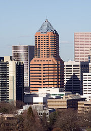
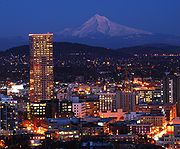
Portland has several high rise buildings. The five tallest are:- Wells Fargo CenterWells Fargo Center (Portland, Oregon)Wells Fargo Center is an office building located in Portland, Oregon, United States. The tower rises 546 feet with 40 floors of office space and three levels of parking below the surface...
: rises to 166 meters (544 feet) and was constructed in 1972 - US Bancorp TowerUS Bancorp Tower (Portland, Oregon)US Bancorp Tower is the second tallest skyscraper in Portland, Oregon. It stands at with 42 floors. The building has nearly of office space inside, making it the largest office building in Oregon in terms of volume, and the second tallest building in Oregon, with only the Wells Fargo Center...
, or "Big Pink": rises to 163 meters (534 feet) and was constructed in 1983 - KOIN CenterKOIN CenterKOIN Center is a , 35-storey, skyscraper in Portland, Oregon. The building, the third tallest in the city, was designed by the firm of Zimmer Gunsul Frasca Partnership and opened in 1984 at a cost of .-History:...
: rises to 155 meters (508 feet) and was constructed in 1984 - PacWest CenterPacWest CenterPacWest Center is an office skyscraper in Portland, Oregon. At , it is the fourth-tallest building in Portland. The 29-story building was designed by Hugh Stubbins & Associates of Cambridge, Massachusetts and completed in 1984....
: rises to 127 meters (416 feet) and was constructed in 1984 - Fox TowerFox Tower (Portland, Oregon)Fox Tower is a 27-story office building in Portland, Oregon. It opened in 2000, making it Portland's most recently opened major office building. TVA Architects designed the building and Tom Moyer developed the property...
: rises to 113 meters (370 feet) and was constructed in 2000
While not located in the downtown area, another notable building is the Oregon Convention Center
Oregon Convention Center
The Oregon Convention Center is a convention center in Portland, Oregon. Opened in 1990, it located on the east side of the Willamette River in the Lloyd District neighborhood. It is best known for the twin spire towers which provide light into the building's interior and for housing the world's...
, the largest convention center
Convention center
A convention center is a large building that is designed to hold a convention, where individuals and groups gather to promote and share common interests. Convention centers typically offer sufficient floor area to accommodate several thousand attendees...
in the Pacific Northwest
Pacific Northwest
The Pacific Northwest is a region in northwestern North America, bounded by the Pacific Ocean to the west and, loosely, by the Rocky Mountains on the east. Definitions of the region vary and there is no commonly agreed upon boundary, even among Pacific Northwesterners. A common concept of the...
, which draws many people across the river to downtown.
Adjacent districts
- Old Town ChinatownOld Town Chinatown, Portland, OregonOld Town Chinatown is a neighborhood in the Northwest section of Portland, Oregon. The Willamette River forms its eastern boundary, separating it from the Lloyd District and the Kerns and Buckman neighborhoods...
– northeast, and extending south of West Burnside St. near the river - Pearl DistrictPearl District, Portland, OregonThe Pearl District is an area of Portland, Oregon, formerly occupied by warehouses, light industry and railroad classification yards and now noted for its art galleries, upscale businesses and residences. The area has been undergoing significant urban renewal since the late 1990s, including the...
– north, adjacent to Chinatown - Goose HollowGoose Hollow, Portland, OregonGoose Hollow is a neighborhood in southwest Portland, Oregon. It acquired its distinctive name through early residents’ practice of letting their geese run free near the wooded ravine in the Tualatin Mountains now known as the Tanner Creek Canyon and in the now infilled Tanner Creek Gulch...
– residential, west of PSU, north of US 26 - Southwest HillsSouthwest Hills, Portland, OregonSouthwest Hills is a neighborhood in the West Hills in the southwest section of Portland, Oregon, United States. The northeastern part of the neighborhood, above Goose Hollow and Downtown Portland, is known as Portland Heights...
– residential, west of PSU, south of US 26 - Marquam HillMarquam Hill, Portland, OregonMarquam Hill is a populated hill located just south of Downtown Portland, Oregon, United States in the Homestead neighborhood. It is also called Pill Hill because it is home to Oregon Health & Science University, Portland VA Medical Center and Portland Shriners Hospital.Marquam Hill was named for...
(colloquially "Pill Hill") – south, including OHSUOregon Health & Science UniversityOregon Health & Science University is a public university in Oregon with a main campus, including two hospitals, in Portland and a smaller campus in Hillsboro...
and the Veteran's Hospital - RiverPlaceRiverplaceRiverplace may refer to:* Riverplace Tower, a skyscraper in Jacksonville, Florida* Riverplace , a JTA Skyway station in Jacksonville, Florida* RiverPlace Condominiums, a proposed residential tower in Baton Rouge, Louisiana...
– at southeast corner of downtown - South WaterfrontSouth WaterfrontThe South Waterfront is a high-rise district under construction on former brownfield industrial land in the South Portland neighborhood south of downtown Portland, Oregon, U.S. It is one of the largest urban redevelopment projects in the United States...
– south of downtown, east of Interstate 5