
Leadfield, California
Encyclopedia
Leadfield was an unincorporated community
, and historic mining town
in Inyo County
, California
. It is now a ghost town
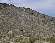
. It is located in Titus Canyon
in the Grapevine Mountains
, east of Death Valley
in Death Valley National Park
. Leadfield lies at an elevation of 4058 feet (1237 m). It is on the National Register of Historic Places
.
 Ore
Ore
was being exploited in Titus Canyon as early as 1905, but the townsite of Leadfield at the head of the canyon dates to the years 1925 and 1926. The product of extensive and fraudulent advertising by the Western Lead Mine Company and C.C. Julian, the town boomed in 1925. His advertising posters showed steamboats navigating the Amargosa River
to Leadfield, ignoring the fact at the Amargosa River is dry much of the time and does not run within 20 miles of Leadfield.
Fifteen miles of road were built up the canyon to connect with the road to Beatty, Nevada
, a concrete
foundation for a Stamp mill
was poured, and the beginning of a series of power poles for electric line
s were installed.
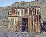
Historic photographs show some frame and corrugated metal buildings and there is evidence of a few dugouts, but the majority of the denizens of Leadfield lived in tents of varying sizes and construction. The population peaked at around 300 in 1926, with a post office opening in August of that year. However, by February 1927, the post office closed down and the town died.
Julian disappeared and the inhabitants soon became disillusioned and quickly drifted away. The significance of the site lies in the fact it was an example of one of the get-rich-quick schemes of the wild 1920s.
, near Beatty, Nevada
.
Unincorporated area
In law, an unincorporated area is a region of land that is not a part of any municipality.To "incorporate" in this context means to form a municipal corporation, a city, town, or village with its own government. An unincorporated community is usually not subject to or taxed by a municipal government...
, and historic mining town
Mining town
A mining community, also known as a mining town or a mining camp, is a community that houses miners. Mining communities are usually created around a mine or a quarry for the extraction or smeltering of ore.-United States:...
in Inyo County
Inyo County, California
-National protected areas:* Death Valley National Park * Inyo National Forest * Manzanar National Historic Site-Major highways:* U.S. Route 6* U.S. Route 395* State Route 127* State Route 136* State Route 168* State Route 178...
, California
California
California is a state located on the West Coast of the United States. It is by far the most populous U.S. state, and the third-largest by land area...
. It is now a ghost town
Ghost town
A ghost town is an abandoned town or city. A town often becomes a ghost town because the economic activity that supported it has failed, or due to natural or human-caused disasters such as floods, government actions, uncontrolled lawlessness, war, or nuclear disasters...
. It is located in Titus Canyon
Titus Canyon
Titus Canyon is a deep, narrow gorge cut into the steep face of the Grapevine Mountains to the east of Death Valley in the Mojave Desert of southeastern California...
in the Grapevine Mountains
Grapevine Mountains
The Grapevine Mountains are located along the eastern border of California in the United States. The mountain range is about long and lies in a northwest-southeasterly direction along the Nevada-California state line. The range reaches an elevation of at Grapevine Peak, near Phinney Canyon on the...
, east of Death Valley
Death Valley
Death Valley is a desert valley located in Eastern California. Situated within the Mojave Desert, it features the lowest, driest, and hottest locations in North America. Badwater, a basin located in Death Valley, is the specific location of the lowest elevation in North America at 282 feet below...
in Death Valley National Park
Death Valley National Park
Death Valley National Park is a national park in the U.S. states of California and Nevada located east of the Sierra Nevada in the arid Great Basin of the United States. The park protects the northwest corner of the Mojave Desert and contains a diverse desert environment of salt-flats, sand dunes,...
. Leadfield lies at an elevation of 4058 feet (1237 m). It is on the National Register of Historic Places
National Register of Historic Places
The National Register of Historic Places is the United States government's official list of districts, sites, buildings, structures, and objects deemed worthy of preservation...
.
History
Ore
An ore is a type of rock that contains minerals with important elements including metals. The ores are extracted through mining; these are then refined to extract the valuable element....
was being exploited in Titus Canyon as early as 1905, but the townsite of Leadfield at the head of the canyon dates to the years 1925 and 1926. The product of extensive and fraudulent advertising by the Western Lead Mine Company and C.C. Julian, the town boomed in 1925. His advertising posters showed steamboats navigating the Amargosa River
Amargosa River
The Amargosa River is an intermittent waterway, long, in southern Nevada and eastern California in the United States. It drains a high desert region, the Amargosa Valley in the Amargosa Desert northwest of Las Vegas, into the Mojave Desert, and finally into Death Valley where it disappears into...
to Leadfield, ignoring the fact at the Amargosa River is dry much of the time and does not run within 20 miles of Leadfield.
Fifteen miles of road were built up the canyon to connect with the road to Beatty, Nevada
Beatty, Nevada
Beatty is a census-designated place along the Amargosa River in Nye County in the U.S. state of Nevada. U.S. Route 95 runs through the CDP, which lies between Tonopah, about to the north, and Las Vegas, about to the southeast. State Route 374 connects Beatty to Death Valley National Park, about ...
, a concrete
Concrete
Concrete is a composite construction material, composed of cement and other cementitious materials such as fly ash and slag cement, aggregate , water and chemical admixtures.The word concrete comes from the Latin word...
foundation for a Stamp mill
Stamp mill
A stamp mill is a type of mill machine that crushes material by pounding rather than grinding, either for further processing or for extraction of metallic ores. Breaking material down is a type of unit operation....
was poured, and the beginning of a series of power poles for electric line
Electric line
Electric line may refer to:*Electrical wiring*Overhead lines that power a railway*Metra Electric Line, a commuter rail line serving the Chicago area...
s were installed.
Historic photographs show some frame and corrugated metal buildings and there is evidence of a few dugouts, but the majority of the denizens of Leadfield lived in tents of varying sizes and construction. The population peaked at around 300 in 1926, with a post office opening in August of that year. However, by February 1927, the post office closed down and the town died.
Julian disappeared and the inhabitants soon became disillusioned and quickly drifted away. The significance of the site lies in the fact it was an example of one of the get-rich-quick schemes of the wild 1920s.
Visiting
The remains of the town include a few rusted metal sheds and two locked, abandoned mine shafts, as of 2005. The town is reachable by one-way Titus Canyon Road at the eastern end of Titus CanyonTitus Canyon
Titus Canyon is a deep, narrow gorge cut into the steep face of the Grapevine Mountains to the east of Death Valley in the Mojave Desert of southeastern California...
, near Beatty, Nevada
Beatty, Nevada
Beatty is a census-designated place along the Amargosa River in Nye County in the U.S. state of Nevada. U.S. Route 95 runs through the CDP, which lies between Tonopah, about to the north, and Las Vegas, about to the southeast. State Route 374 connects Beatty to Death Valley National Park, about ...
.