
Origins of the Sino-Indian border dispute
Encyclopedia
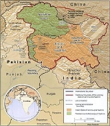
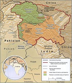
Sovereignty
over two separated pieces of territory was contested during the Sino-Indian War
. One is Aksai Chin
is located either in the Indian province of Kashmir
or the Chinese province of Xinjiang
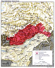
in the west. It is a virtually uninhabited high-altitude wasteland crossed by the Xinjiang-Tibet Highway. The other disputed area lies to the east is referred to as Arunachal Pradesh
by India and South Tibet by China. It is a sparsely inhabited area with numerous local tribes.
 At 17,000 feet elevation, the desolation of Aksai Chin had no human importance other than an ancient trade route that crossed over it, providing a brief pass during summer for caravans of yaks between Xinjiang and Tibet.
One of the earliest treaties regarding the boundaries in the western sector was issued in 1842. The Sikh Confederacy
of the Punjab region
in India had annexed Ladakh
into the state of Jammu
in 1834. In 1841, they invaded Tibet with an army. Chinese forces defeated the Sikh army and in turn entered Ladakh and besieged Leh. After being checked by the Sikh forces, the Chinese and the Sikhs signed a treaty in September 1842, which stipulated no transgressions or interference in the other country's frontiers. The British defeat of the Sikhs in 1846
resulted in transfer of sovereignty over Ladakh to the British, and British commissioners attempted to meet with Chinese officials to discuss the border they now shared. However, both sides were apparently sufficiently satisfied that a traditional border was recognized and defined by natural delements, and the border was not demarcated. The boundaries at the two extremities, Pangong Lake and Karakoram Pass
, were well-defined, but the Aksai Chin area in between lay undefined.
 W. H. Johnson, a civil servant with the Survey of India
proposed the "Johnson Line" in 1865, which put Aksai Chin in Kashmir. This was the time of the Dungan revolt, when China did not control Xinjiang
, so this line was never presented to the Chinese. Johnson presented this line to the Maharaja of Kashmir, who then claimed the 18,000 square kilometres contained within, and by some accounts territory further north as far as the Sanju Pass
in the Kun Lun Mountains. Johnson's work was severely criticized for gross inaccuracies, with description of his boundary as "patently absurd", and he was reprimanded by the British Government and resigned from the Survey. The Maharajah of Kashmir apparently sent a few soldiers to man the abandoned fort at Shahidulla (modern-day Xaidulla
) at one point, by the time most sources placed Shahidulla and the upper Karakash River
firmly within the territory of Xinjiang (see accompanying map). According to Francis Younghusband
, who explored the region in the late 1880s, there was only an abandoned fort and not one inhabited house at Shahidulla when he was there - it was just a convenient staging post and a convenient headquarters for the nomadic Kirghiz. The abandoned fort had apparently been built a few years earlier by the Kashmiris. In 1878 the Chinese had reconquered Xinjiang, and by 1890 they already had Shahidulla before the issue was decided. By 1892, China had erected boundary markers at Karakoram Pass
.
In 1897 a British military officer, Sir John Ardagh, proposed a boundary line along the crest of the Kun Lun Mountains north of the Yarkand River
. At the time Britain was concerned at the danger of Russian expansion as China weakened, and Ardagh argued that his line was more defensible. The Ardagh line was effectively a modification of the Johnson line, and became known as the "Johnson-Ardagh Line".
n hands. In 1899, when China showed an interest in Aksai Chin, Britain proposed a revised boundary, initially suggested by George Macartney, which put most of Aksai Chin in Chinese territory. This border, along the Karakoram Mountains, was proposed and supported by British officials for a number of reasons. The Karakoram Mountains formed a natural boundary, which would set the British borders up to the Indus River
watershed
while leaving the Tarim River
watershed in Chinese control, and Chinese control of this tract would present a further obstacle to Russian advance in Central Asia. The British presented this line to the Chinese in a Note by Sir Claude MacDonald. The Chinese did not respond to the Note, and the British took that as Chinese acquiescence. This line, known as the Macartney-MacDonald line, is approximately the same as the current Line of Actual Control
.
resulted in the collapse of central power in China, and by the end of World War I
, the British officially used the Johnson Line. However they took no steps to establish outposts or assert actual control on the ground. In 1927, the line was adjusted again as the government of British India abandoned the Johnson line in favor of a line along the Karakoram range further south. However, the maps were not updated and still showed the Johnson Line.
When British officials learned of Soviet officials surveying the Aksai Chin for Sheng Shicai
, warlord of Xinjiang
in 1940-1941, they again advocated the Johnson Line. At this point the British had still made no attempts to establish outposts or control over the Aksai Chin, nor was the issue ever discussed with the governments of China or Tibet, and the boundary remained undemarcated at India's independence.
used the Johnson Line as the basis for its official boundary in the west, which included the Aksai Chin From the Karakoram Pass (which is not under dispute), the Indian claim line extends northeast of the Karakoram Mountains through the salt flats of the Aksai Chin, to set a boundary at the Kunlun Mountains
, and incorporating part of the Karakash River
and Yarkand River
watersheds. From there, it runs east along the Kunlun Mountains, before turning southwest through the Aksai Chin salt flats, through the Karakoram Mountains, and then to Panggong Lake.
On July 1, 1954 Prime Minister Nehru wrote a memo directing that the maps of India be revised to show definite boundaries on all frontiers. Up to this point, the boundary in the Aksai Chin
sector, based on the Johnson Line, had been described as "undemarcated."
During the 1950s, the People's Republic of China
built a 1,200 km (750 mi) road connecting Xinjiang
and western Tibet
, of which 179 km (112 mi) ran south of the Johnson Line through the Aksai Chin region claimed by India. Aksai Chin was easily accessible to the Chinese, but was more difficult for the Indians on the other side of the Karakorams to reach. The Indians did not learn of the existence of the road until 1957, which was confirmed when the road was shown in Chinese maps published in 1958.
The Indian position, as stated by prime minister Jawalharlal Nehru, was that the Aksai Chin was "part of the Ladakh region
of India for centuries" and that this northern border was a "firm and definite one which was not open to discussion with anybody".
The Chinese minister, Zhou Enlai
argued that the western border had never been delimited, that the Macartney-MacDonald Line, which left the Aksai Chin within Chinese borders was the only line ever proposed to a Chinese government, and that the Aksai Chin was already under Chinese jurisdiction, and that negotiations should take into account the status quo.
, where China adjoins Pakistan-administered Gilgit-Baltistan. On October 13, 1962, China and Pakistan began negotiations over the boundary west of the Karakoram Pass. In 1963, the two countries settled their boundaries largely on the basis of the Macartney-MacDonald Line, which left the Trans Karakoram Tract in China, although the agreement provided for renegotiation in the event of a settlement of the Kashmir dispute. India does not recognise that Pakistan and China have a common border, and claims the tract as part of the domains of the pre-1947 state of Kashmir and Jammu. However, India's claim line in that area does not extend as far north of the Karakoram
Mountains as the Johnson Line
 British India and China gained a common border in 1826, with British annexation of Assam
in the Treaty of Yandabo
at the conclusion of the First Anglo-Burmese War (1824–1826). Subsequent annexations in further Anglo-Burmese Wars expanded China's borders with British India eastwards, to include the border with what is now Myanmar
.
In 1913-14, representatives of Britain, China, and Tibet
attended a conference in Simla
, India and drew up an agreement concerning Tibet's status and borders. The McMahon Line
, a proposed boundary between Tibet and India for the eastern sector, was drawn by British negotiator Henry McMahon
on a map attached to the agreement. All three representatives initiated the agreement, but Beijing immediately objected to the proposed Sino-Tibet boundary and repudiated the agreement. After approving a note which stated that China could not enjoy rights under the agreement unless she ratified it, the British and Tibetan negotiators signed the Simla Convention as a bilateral accord. Neville Maxwell
states that McMahon had been instructed not to sign bilaterally with Tibetans if China refused, but he did so without the Chinese representative present and then kept the declaration secret.
V.K. Singh argues that the basis of these boundaries, accepted by British India and Tibet, were that the historical boundaries of India were the Himalayas
and the areas south of the Himalayas were traditionally Indian and associated with India. The high watershed of the Himalayas was proposed as the border between India and its northern neighbours. India's government held the view that the Himalayas were the ancient boundaries of the Indian subcontinent
and thus should be the modern boundaries of British India and later the Republic of India.
Chinese boundary markers, including one set up by the newly created Chinese Republic, stood near Walong
until January 1914, when T. O'Callaghan, an assistant administrator of NEFA's eastern sector, relocated them north to locations closer to the McMahon Line (albeit still South of the Line). He then went to Rima, met with Tibetan officials, and saw no Chinese influence in the area.
By signing the Simla Agreement with Tibet, the British had violated the Anglo-Russian Convention of 1907, in which both parties were not to negotiate with Tibet, "except through the intermediary of the Chinese Government", as well as the Anglo-Chinese Convention of 1906, which bound the British government "not to annex Tibetan territory." Because of doubts concerning the legal status of the accord, the British did not put the McMahon Line on their maps until 1937, nor did they publish the Simla Convention in the treaty record until 1938. Rejecting Tibet's 1913 declaration of independence, China argued that the Simla Convention and McMahon Line were illegal and that Tibetan government was merely a local government without treaty-making powers. In 1947, Tibet requested that India recognize Tibetan authority in the trading town of Tawang, south of the McMahon Line. Tibet did not object to any other portion of the McMahon line. In reply, the Indians asked Tibet to continue the relationship on the basis of the previous British Government.
Tibetan officials continued to administer Tawang
and refused to concede territory during negotiations in 1938. The governor of Assam asserted that Tawang was "undoubtedly British" but noted that it was "controlled by Tibet, and none of its inhabitants have any idea that they are not Tibetan." During World War II, with India's east threatened by Japanese troops and with the threat of Chinese expansionism, British troops secured Tawang for extra defense.
China's claim on areas south of the McMahon Line, encompassed in the North East Frontier Agency, were based on traditional boundaries. India believes that the boundaries China proposed in Ladakh
and Arunachal Pradesh
have no written basis and no documentation of acceptance by anyone apart from China. Indians argue that China claims the territory on the basis that it was under Chinese imperial control in the past, while Chinese argue that India claims the territory on the basis that it was under British imperial control in the past The last Qing
emperor's 1912 edict of abdication authorized its succeeding republican government
to form a union of "five peoples, namely, Manchus, Han Chinese
, Mongols
, Muslims
, and Tibetans together with their territory in its integrity" However, V.K. Singh cites the presence of the Mauryan Empire and Chola Dynasty
in regions India does not place a claim to but which were heavily influenced by Indian culture.
Parts of India's claim line in the eastern sector follows a modified version of the McMahon Line. The original line drawn up by Henry McMahon on the Simla Treaty map starts at 27°44’30’’N, starting a trijunction between Bhutan, China, and India, and from there, extends eastwards. Most of the fighting in the eastern sector before the start of the war would take place north of this line. However, India claims that the intent of the treaty was to follow the highest ridges of the Himalayas. They claimed that South of the high ridges should be Indian territory and North of the high ridges should be Chinese territory. In the Indian claim, the two armies would be separated from each other by the highest mountains in the world.
Starting from the 1950s, when India began patrolling this area, they found that they at multiple locations, the highest ridges fell north of the McMahon Line as shown in the treaty map and their own maps, and they modified their maps to extend northwards to include features such as Thag La, Longju, and Khinzemane as Indian territory. Thus, the Indian version of the McMahon Line moves the Bhutan-China-India trijunction north to 27°48’N. India would claim that the treaty map ran along features such as Thag La, though the actual treaty map itself is topographically vague (as the treaty was not accompanied with demarcation), and the treaty includes no verbal description of geographic features nor description of the highest ridges.
Sovereignty
Sovereignty is the quality of having supreme, independent authority over a geographic area, such as a territory. It can be found in a power to rule and make law that rests on a political fact for which no purely legal explanation can be provided...
over two separated pieces of territory was contested during the Sino-Indian War
Sino-Indian War
The Sino-Indian War , also known as the Sino-Indian Border Conflict , was a war between China and India that occurred in 1962. A disputed Himalayan border was the main pretext for war, but other issues played a role. There had been a series of violent border incidents after the 1959 Tibetan...
. One is Aksai Chin
Aksai Chin
Aksai Chin is one of the two main disputed border areas between China and India, and the other is South Tibet, which comprises most of India's Arunachal Pradesh. It is administered by China as part of Hotan County in the Hotan Prefecture of Xinjiang Autonomous Region, but is also claimed by India...
is located either in the Indian province of Kashmir
Kashmir
Kashmir is the northwestern region of the Indian subcontinent. Until the mid-19th century, the term Kashmir geographically denoted only the valley between the Great Himalayas and the Pir Panjal mountain range...
or the Chinese province of Xinjiang
Xinjiang
Xinjiang is an autonomous region of the People's Republic of China. It is the largest Chinese administrative division and spans over 1.6 million km2...
in the west. It is a virtually uninhabited high-altitude wasteland crossed by the Xinjiang-Tibet Highway. The other disputed area lies to the east is referred to as Arunachal Pradesh
Arunachal Pradesh
Arunachal Pradesh is a state of India, located in the far northeast. It borders the states of Assam and Nagaland to the south, and shares international borders with Burma in the east, Bhutan in the west, and the People's Republic of China in the north. The majority of the territory is claimed by...
by India and South Tibet by China. It is a sparsely inhabited area with numerous local tribes.
Aksai Chin
One of the earliest treaties regarding the boundaries in the western sector was issued in 1842. The Sikh Confederacy
Sikh Confederacy
The Sikh Empire was an imperial power from the Indian Subcontinent. The empire, based around the Punjab region, existed from 1799 to 1849. It was forged, on the foundations of the Khalsa, under the leadership of Maharaja Ranjit Singh from a collection of autonomous Punjabi Misls...
of the Punjab region
Punjab region
The Punjab , also spelled Panjab |water]]s"), is a geographical region straddling the border between Pakistan and India which includes Punjab province in Pakistan and the states of the Punjab, Haryana, Himachal Pradesh, Chandigarh and some northern parts of the National Capital Territory of Delhi...
in India had annexed Ladakh
Ladakh
Ladakh is a region of Jammu and Kashmir, the northernmost state of the Republic of India. It lies between the Kunlun mountain range in the north and the main Great Himalayas to the south, inhabited by people of Indo-Aryan and Tibetan descent...
into the state of Jammu
Jammu
Jammu , also known as Duggar, is one of the three administrative divisions within Jammu and Kashmir, the northernmost state in India.Jammu city is the largest city in Jammu and the winter capital of Jammu and Kashmir...
in 1834. In 1841, they invaded Tibet with an army. Chinese forces defeated the Sikh army and in turn entered Ladakh and besieged Leh. After being checked by the Sikh forces, the Chinese and the Sikhs signed a treaty in September 1842, which stipulated no transgressions or interference in the other country's frontiers. The British defeat of the Sikhs in 1846
Second Anglo-Sikh War
The Second Anglo-Sikh War took place in 1848 and 1849, between the Sikh Empire and the British East India Company. It resulted in the subjugation of the Sikh Empire, and the annexation of the Punjab and what subsequently became the North-West Frontier Province by the East India Company.-Background...
resulted in transfer of sovereignty over Ladakh to the British, and British commissioners attempted to meet with Chinese officials to discuss the border they now shared. However, both sides were apparently sufficiently satisfied that a traditional border was recognized and defined by natural delements, and the border was not demarcated. The boundaries at the two extremities, Pangong Lake and Karakoram Pass
Karakoram Pass
The Karakoram Pass is a mountain pass between India and China in the Karakoram Range. It is the highest pass on the ancient caravan route between Leh in Ladakh and Yarkand in the Tarim Basin...
, were well-defined, but the Aksai Chin area in between lay undefined.
The Johnson Line
Survey of India
The Survey of India is India's central engineering agency in charge of mapping and surveying. Set up in 1767 to help consolidate the territories of the British East India Company, it is one of the oldest Engineering Departments of the Government of India...
proposed the "Johnson Line" in 1865, which put Aksai Chin in Kashmir. This was the time of the Dungan revolt, when China did not control Xinjiang
Xinjiang
Xinjiang is an autonomous region of the People's Republic of China. It is the largest Chinese administrative division and spans over 1.6 million km2...
, so this line was never presented to the Chinese. Johnson presented this line to the Maharaja of Kashmir, who then claimed the 18,000 square kilometres contained within, and by some accounts territory further north as far as the Sanju Pass
Sanju Pass
The Sanju, or Sanju-la, is a mountain pass in the Kun Lun Mountains in Xinjiang, China. It was the last on a series of difficult passes on the most common summer caravan route between Ladakh and the Tarim Basin....
in the Kun Lun Mountains. Johnson's work was severely criticized for gross inaccuracies, with description of his boundary as "patently absurd", and he was reprimanded by the British Government and resigned from the Survey. The Maharajah of Kashmir apparently sent a few soldiers to man the abandoned fort at Shahidulla (modern-day Xaidulla
Xaidulla
Xaidulla, Shahidullah or Shahidula is a small settlement or camping ground on the upper Karakash River strategically located just to the north of the Karakoram Pass on the old caravan route from the Tarim Basin to Ladakh...
) at one point, by the time most sources placed Shahidulla and the upper Karakash River
Karakash River
The Karakash or Black Jade River, also spelled Karakax , is a river in the Xinjiang autonomous region of the People's Republic of China, which lies partially in the disputed Aksai Chin region. The river originates near Sumde on the northern slopes of the Karakoram range in the Aksai Chin region of...
firmly within the territory of Xinjiang (see accompanying map). According to Francis Younghusband
Francis Younghusband
Lieutenant Colonel Sir Francis Edward Younghusband, KCSI, KCIE was a British Army officer, explorer, and spiritual writer...
, who explored the region in the late 1880s, there was only an abandoned fort and not one inhabited house at Shahidulla when he was there - it was just a convenient staging post and a convenient headquarters for the nomadic Kirghiz. The abandoned fort had apparently been built a few years earlier by the Kashmiris. In 1878 the Chinese had reconquered Xinjiang, and by 1890 they already had Shahidulla before the issue was decided. By 1892, China had erected boundary markers at Karakoram Pass
Karakoram Pass
The Karakoram Pass is a mountain pass between India and China in the Karakoram Range. It is the highest pass on the ancient caravan route between Leh in Ladakh and Yarkand in the Tarim Basin...
.
In 1897 a British military officer, Sir John Ardagh, proposed a boundary line along the crest of the Kun Lun Mountains north of the Yarkand River
Yarkand River
The Yarkand River is a river in the Xinjiang Uyghur Autonomous Region of western China. It is one of the headstreams of the Tarim River. It is approximately 970 km in length....
. At the time Britain was concerned at the danger of Russian expansion as China weakened, and Ardagh argued that his line was more defensible. The Ardagh line was effectively a modification of the Johnson line, and became known as the "Johnson-Ardagh Line".
The Macartney-Macdonald Line
In the 1890s Britain and China were allies and Britain was principally concerned that Aksai Chin not fall into RussiaRussia
Russia or , officially known as both Russia and the Russian Federation , is a country in northern Eurasia. It is a federal semi-presidential republic, comprising 83 federal subjects...
n hands. In 1899, when China showed an interest in Aksai Chin, Britain proposed a revised boundary, initially suggested by George Macartney, which put most of Aksai Chin in Chinese territory. This border, along the Karakoram Mountains, was proposed and supported by British officials for a number of reasons. The Karakoram Mountains formed a natural boundary, which would set the British borders up to the Indus River
Indus River
The Indus River is a major river which flows through Pakistan. It also has courses through China and India.Originating in the Tibetan plateau of western China in the vicinity of Lake Mansarovar in Tibet Autonomous Region, the river runs a course through the Ladakh district of Jammu and Kashmir and...
watershed
Water divide
A drainage divide, water divide, divide or watershed is the line separating neighbouring drainage basins...
while leaving the Tarim River
Tarim River
The Tarim River is the principal river of the Xinjiang Uygur Autonomous Region in the People's Republic of China...
watershed in Chinese control, and Chinese control of this tract would present a further obstacle to Russian advance in Central Asia. The British presented this line to the Chinese in a Note by Sir Claude MacDonald. The Chinese did not respond to the Note, and the British took that as Chinese acquiescence. This line, known as the Macartney-MacDonald line, is approximately the same as the current Line of Actual Control
Line of Actual Control
The Line of Actual Control is the effective border between India and People's Republic of China . The LAC is 4,057-km long and traverses three areas of northern Indian states: western , middle and eastern...
.
1899 to 1947
Both the Johnson-Ardagh and the Macartney-MacDonald lines were used on British maps of India. Until at least 1908, the British took the Macdonald line to be the boundary, but in 1911, the Xinhai RevolutionXinhai Revolution
The Xinhai Revolution or Hsinhai Revolution, also known as Revolution of 1911 or the Chinese Revolution, was a revolution that overthrew China's last imperial dynasty, the Qing , and established the Republic of China...
resulted in the collapse of central power in China, and by the end of World War I
World War I
World War I , which was predominantly called the World War or the Great War from its occurrence until 1939, and the First World War or World War I thereafter, was a major war centred in Europe that began on 28 July 1914 and lasted until 11 November 1918...
, the British officially used the Johnson Line. However they took no steps to establish outposts or assert actual control on the ground. In 1927, the line was adjusted again as the government of British India abandoned the Johnson line in favor of a line along the Karakoram range further south. However, the maps were not updated and still showed the Johnson Line.
When British officials learned of Soviet officials surveying the Aksai Chin for Sheng Shicai
Sheng Shicai
Sheng Shicai was a Chinese warlord who "ruled" Xinjiang province from April 12, 1933 to August 29, 1944....
, warlord of Xinjiang
Xinjiang
Xinjiang is an autonomous region of the People's Republic of China. It is the largest Chinese administrative division and spans over 1.6 million km2...
in 1940-1941, they again advocated the Johnson Line. At this point the British had still made no attempts to establish outposts or control over the Aksai Chin, nor was the issue ever discussed with the governments of China or Tibet, and the boundary remained undemarcated at India's independence.
Since 1947
Upon independence in 1947, the government of IndiaIndia
India , officially the Republic of India , is a country in South Asia. It is the seventh-largest country by geographical area, the second-most populous country with over 1.2 billion people, and the most populous democracy in the world...
used the Johnson Line as the basis for its official boundary in the west, which included the Aksai Chin From the Karakoram Pass (which is not under dispute), the Indian claim line extends northeast of the Karakoram Mountains through the salt flats of the Aksai Chin, to set a boundary at the Kunlun Mountains
Kunlun Mountains
The Kunlun Mountains are one of the longest mountain chains in Asia, extending more than 3,000 km. In the broadest sense, it forms the northern edge of the Tibetan Plateau south of the Tarim Basin and the Gansu Corridor and continues east south of the Wei River to end at the North China Plain.The...
, and incorporating part of the Karakash River
Karakash River
The Karakash or Black Jade River, also spelled Karakax , is a river in the Xinjiang autonomous region of the People's Republic of China, which lies partially in the disputed Aksai Chin region. The river originates near Sumde on the northern slopes of the Karakoram range in the Aksai Chin region of...
and Yarkand River
Yarkand River
The Yarkand River is a river in the Xinjiang Uyghur Autonomous Region of western China. It is one of the headstreams of the Tarim River. It is approximately 970 km in length....
watersheds. From there, it runs east along the Kunlun Mountains, before turning southwest through the Aksai Chin salt flats, through the Karakoram Mountains, and then to Panggong Lake.
On July 1, 1954 Prime Minister Nehru wrote a memo directing that the maps of India be revised to show definite boundaries on all frontiers. Up to this point, the boundary in the Aksai Chin
Aksai Chin
Aksai Chin is one of the two main disputed border areas between China and India, and the other is South Tibet, which comprises most of India's Arunachal Pradesh. It is administered by China as part of Hotan County in the Hotan Prefecture of Xinjiang Autonomous Region, but is also claimed by India...
sector, based on the Johnson Line, had been described as "undemarcated."
During the 1950s, the People's Republic of China
People's Republic of China
China , officially the People's Republic of China , is the most populous country in the world, with over 1.3 billion citizens. Located in East Asia, the country covers approximately 9.6 million square kilometres...
built a 1,200 km (750 mi) road connecting Xinjiang
Xinjiang
Xinjiang is an autonomous region of the People's Republic of China. It is the largest Chinese administrative division and spans over 1.6 million km2...
and western Tibet
Tibet
Tibet is a plateau region in Asia, north-east of the Himalayas. It is the traditional homeland of the Tibetan people as well as some other ethnic groups such as Monpas, Qiang, and Lhobas, and is now also inhabited by considerable numbers of Han and Hui people...
, of which 179 km (112 mi) ran south of the Johnson Line through the Aksai Chin region claimed by India. Aksai Chin was easily accessible to the Chinese, but was more difficult for the Indians on the other side of the Karakorams to reach. The Indians did not learn of the existence of the road until 1957, which was confirmed when the road was shown in Chinese maps published in 1958.
The Indian position, as stated by prime minister Jawalharlal Nehru, was that the Aksai Chin was "part of the Ladakh region
Ladakh
Ladakh is a region of Jammu and Kashmir, the northernmost state of the Republic of India. It lies between the Kunlun mountain range in the north and the main Great Himalayas to the south, inhabited by people of Indo-Aryan and Tibetan descent...
of India for centuries" and that this northern border was a "firm and definite one which was not open to discussion with anybody".
The Chinese minister, Zhou Enlai
Zhou Enlai
Zhou Enlai was the first Premier of the People's Republic of China, serving from October 1949 until his death in January 1976...
argued that the western border had never been delimited, that the Macartney-MacDonald Line, which left the Aksai Chin within Chinese borders was the only line ever proposed to a Chinese government, and that the Aksai Chin was already under Chinese jurisdiction, and that negotiations should take into account the status quo.
Trans Karakoram Tract
The Johnson Line is not used west of the Karakoram PassKarakoram Pass
The Karakoram Pass is a mountain pass between India and China in the Karakoram Range. It is the highest pass on the ancient caravan route between Leh in Ladakh and Yarkand in the Tarim Basin...
, where China adjoins Pakistan-administered Gilgit-Baltistan. On October 13, 1962, China and Pakistan began negotiations over the boundary west of the Karakoram Pass. In 1963, the two countries settled their boundaries largely on the basis of the Macartney-MacDonald Line, which left the Trans Karakoram Tract in China, although the agreement provided for renegotiation in the event of a settlement of the Kashmir dispute. India does not recognise that Pakistan and China have a common border, and claims the tract as part of the domains of the pre-1947 state of Kashmir and Jammu. However, India's claim line in that area does not extend as far north of the Karakoram
Karakoram
The Karakoram, or Karakorum , is a large mountain range spanning the borders between Pakistan, India and China, located in the regions of Gilgit-Baltistan , Ladakh , and Xinjiang region,...
Mountains as the Johnson Line
The McMahon Line
Assam
Assam , also, rarely, Assam Valley and formerly the Assam Province , is a northeastern state of India and is one of the most culturally and geographically distinct regions of the country...
in the Treaty of Yandabo
Treaty of Yandabo
The Treaty of Yandabo was the peace treaty that ended the First Anglo-Burmese War. The treaty was signed on 24 February 1826, nearly two years after the war formally broke out on 5 March 1824, by General Sir Archibald Campbell on the British side, and by Governor of Legaing Maha Min Hla Kyaw Htin...
at the conclusion of the First Anglo-Burmese War (1824–1826). Subsequent annexations in further Anglo-Burmese Wars expanded China's borders with British India eastwards, to include the border with what is now Myanmar
Myanmar
Burma , officially the Republic of the Union of Myanmar , is a country in Southeast Asia. Burma is bordered by China on the northeast, Laos on the east, Thailand on the southeast, Bangladesh on the west, India on the northwest, the Bay of Bengal to the southwest, and the Andaman Sea on the south....
.
In 1913-14, representatives of Britain, China, and Tibet
Tibet
Tibet is a plateau region in Asia, north-east of the Himalayas. It is the traditional homeland of the Tibetan people as well as some other ethnic groups such as Monpas, Qiang, and Lhobas, and is now also inhabited by considerable numbers of Han and Hui people...
attended a conference in Simla
Shimla
Shimla , formerly known as Simla, is the capital city of Himachal Pradesh. In 1864, Shimla was declared the summer capital of the British Raj in India. A popular tourist destination, Shimla is often referred to as the "Queen of Hills," a term coined by the British...
, India and drew up an agreement concerning Tibet's status and borders. The McMahon Line
McMahon Line
The McMahon Line is a line agreed to by Great Britain and Tibet as part of Simla Accord, a treaty signed in 1914. Although its legal status is disputed by China, it is the effective boundary between China and India....
, a proposed boundary between Tibet and India for the eastern sector, was drawn by British negotiator Henry McMahon
Henry McMahon (diplomat)
Lieutenant-Colonel Sir Arthur Henry McMahon, GCMG, GCVO, KCIE, CSI was a British diplomat and Indian Army officer who served as the High Commissioner in Egypt from 1915 to 1917. He was also an administrator in British India, and served twice as Chief Commissioner of Balochistan...
on a map attached to the agreement. All three representatives initiated the agreement, but Beijing immediately objected to the proposed Sino-Tibet boundary and repudiated the agreement. After approving a note which stated that China could not enjoy rights under the agreement unless she ratified it, the British and Tibetan negotiators signed the Simla Convention as a bilateral accord. Neville Maxwell
Neville Maxwell
Neville Maxwell is a British journalist.Born in London, Maxwell was educated at McGill University and Cambridge University. He joined The Times as a foreign correspondent in 1955 and spent three years in the Washington bureau. In 1959 he was posted to New Delhi as South Asia correspondent...
states that McMahon had been instructed not to sign bilaterally with Tibetans if China refused, but he did so without the Chinese representative present and then kept the declaration secret.
V.K. Singh argues that the basis of these boundaries, accepted by British India and Tibet, were that the historical boundaries of India were the Himalayas
Himalayas
The Himalaya Range or Himalaya Mountains Sanskrit: Devanagari: हिमालय, literally "abode of snow"), usually called the Himalayas or Himalaya for short, is a mountain range in Asia, separating the Indian subcontinent from the Tibetan Plateau...
and the areas south of the Himalayas were traditionally Indian and associated with India. The high watershed of the Himalayas was proposed as the border between India and its northern neighbours. India's government held the view that the Himalayas were the ancient boundaries of the Indian subcontinent
Indian subcontinent
The Indian subcontinent, also Indian Subcontinent, Indo-Pak Subcontinent or South Asian Subcontinent is a region of the Asian continent on the Indian tectonic plate from the Hindu Kush or Hindu Koh, Himalayas and including the Kuen Lun and Karakoram ranges, forming a land mass which extends...
and thus should be the modern boundaries of British India and later the Republic of India.
Chinese boundary markers, including one set up by the newly created Chinese Republic, stood near Walong
Walong
Walong is a small cantonment and administrative town in the Anjaw District of the state of Arunachal Pradesh in northeastern India. Walong is also the easternmost town in India Anjaw was carved out of Lohit District in 2004. Walong's approximate position is 28 degrees 06 minutes North, 97 degrees...
until January 1914, when T. O'Callaghan, an assistant administrator of NEFA's eastern sector, relocated them north to locations closer to the McMahon Line (albeit still South of the Line). He then went to Rima, met with Tibetan officials, and saw no Chinese influence in the area.
By signing the Simla Agreement with Tibet, the British had violated the Anglo-Russian Convention of 1907, in which both parties were not to negotiate with Tibet, "except through the intermediary of the Chinese Government", as well as the Anglo-Chinese Convention of 1906, which bound the British government "not to annex Tibetan territory." Because of doubts concerning the legal status of the accord, the British did not put the McMahon Line on their maps until 1937, nor did they publish the Simla Convention in the treaty record until 1938. Rejecting Tibet's 1913 declaration of independence, China argued that the Simla Convention and McMahon Line were illegal and that Tibetan government was merely a local government without treaty-making powers. In 1947, Tibet requested that India recognize Tibetan authority in the trading town of Tawang, south of the McMahon Line. Tibet did not object to any other portion of the McMahon line. In reply, the Indians asked Tibet to continue the relationship on the basis of the previous British Government.
Tibetan officials continued to administer Tawang
Tawang District
Tawang district is one of the 16 administrative districts of Arunachal Pradesh in eastern India. The area is historically Tibetan territory and is claimed by both India and Republic of China as a part of South Tibet...
and refused to concede territory during negotiations in 1938. The governor of Assam asserted that Tawang was "undoubtedly British" but noted that it was "controlled by Tibet, and none of its inhabitants have any idea that they are not Tibetan." During World War II, with India's east threatened by Japanese troops and with the threat of Chinese expansionism, British troops secured Tawang for extra defense.
China's claim on areas south of the McMahon Line, encompassed in the North East Frontier Agency, were based on traditional boundaries. India believes that the boundaries China proposed in Ladakh
Ladakh
Ladakh is a region of Jammu and Kashmir, the northernmost state of the Republic of India. It lies between the Kunlun mountain range in the north and the main Great Himalayas to the south, inhabited by people of Indo-Aryan and Tibetan descent...
and Arunachal Pradesh
Arunachal Pradesh
Arunachal Pradesh is a state of India, located in the far northeast. It borders the states of Assam and Nagaland to the south, and shares international borders with Burma in the east, Bhutan in the west, and the People's Republic of China in the north. The majority of the territory is claimed by...
have no written basis and no documentation of acceptance by anyone apart from China. Indians argue that China claims the territory on the basis that it was under Chinese imperial control in the past, while Chinese argue that India claims the territory on the basis that it was under British imperial control in the past The last Qing
Qing Dynasty
The Qing Dynasty was the last dynasty of China, ruling from 1644 to 1912 with a brief, abortive restoration in 1917. It was preceded by the Ming Dynasty and followed by the Republic of China....
emperor's 1912 edict of abdication authorized its succeeding republican government
Republic of China
The Republic of China , commonly known as Taiwan , is a unitary sovereign state located in East Asia. Originally based in mainland China, the Republic of China currently governs the island of Taiwan , which forms over 99% of its current territory, as well as Penghu, Kinmen, Matsu and other minor...
to form a union of "five peoples, namely, Manchus, Han Chinese
Han Chinese
Han Chinese are an ethnic group native to China and are the largest single ethnic group in the world.Han Chinese constitute about 92% of the population of the People's Republic of China , 98% of the population of the Republic of China , 78% of the population of Singapore, and about 20% of the...
, Mongols
Mongols
Mongols ) are a Central-East Asian ethnic group that lives mainly in the countries of Mongolia, China, and Russia. In China, ethnic Mongols can be found mainly in the central north region of China such as Inner Mongolia...
, Muslims
Hui people
The Hui people are an ethnic group in China, defined as Chinese speaking people descended from foreign Muslims. They are typically distinguished by their practice of Islam, however some also practice other religions, and many are direct descendants of Silk Road travelers.In modern People's...
, and Tibetans together with their territory in its integrity" However, V.K. Singh cites the presence of the Mauryan Empire and Chola Dynasty
Chola Dynasty
The Chola dynasty was a Tamil dynasty which was one of the longest-ruling in some parts of southern India. The earliest datable references to this Tamil dynasty are in inscriptions from the 3rd century BC left by Asoka, of Maurya Empire; the dynasty continued to govern over varying territory until...
in regions India does not place a claim to but which were heavily influenced by Indian culture.
Parts of India's claim line in the eastern sector follows a modified version of the McMahon Line. The original line drawn up by Henry McMahon on the Simla Treaty map starts at 27°44’30’’N, starting a trijunction between Bhutan, China, and India, and from there, extends eastwards. Most of the fighting in the eastern sector before the start of the war would take place north of this line. However, India claims that the intent of the treaty was to follow the highest ridges of the Himalayas. They claimed that South of the high ridges should be Indian territory and North of the high ridges should be Chinese territory. In the Indian claim, the two armies would be separated from each other by the highest mountains in the world.
Starting from the 1950s, when India began patrolling this area, they found that they at multiple locations, the highest ridges fell north of the McMahon Line as shown in the treaty map and their own maps, and they modified their maps to extend northwards to include features such as Thag La, Longju, and Khinzemane as Indian territory. Thus, the Indian version of the McMahon Line moves the Bhutan-China-India trijunction north to 27°48’N. India would claim that the treaty map ran along features such as Thag La, though the actual treaty map itself is topographically vague (as the treaty was not accompanied with demarcation), and the treaty includes no verbal description of geographic features nor description of the highest ridges.