
Mount Diablo State Park
Encyclopedia
Contra Costa County, California
Contra Costa County is a primarily suburban county in the San Francisco Bay Area of the U.S. state of California. As of the 2010 census, it had a population of 1,049,025...
in the San Francisco Bay Area
San Francisco Bay Area
The San Francisco Bay Area, commonly known as the Bay Area, is a populated region that surrounds the San Francisco and San Pablo estuaries in Northern California. The region encompasses metropolitan areas of San Francisco, Oakland, and San Jose, along with smaller urban and rural areas...
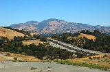
, located south of Clayton
Clayton, California
Clayton is a city in Contra Costa County, California, United States. The population was 10,897 as of the 2010 census.- Geography :...
and northeast of Danville
Danville, California
The Town of Danville is located in the San Ramon Valley in Contra Costa County, California. It is one of the incorporated municipalities in California that uses "town" in its name instead of "city". The population was 42,039 in 2010. Danville is one of the wealthiest suburbs of Oakland and San...
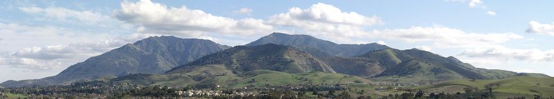
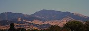
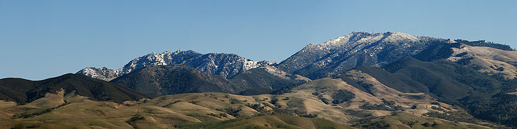
. It is an isolated upthrust peak of 3864 feet (1,178 m), visible from most of the San Francisco Bay Area and much of northern California. Mount Diablo appears from many angles to be a double pyramid and includes many subsidiary peaks, the largest and closest of which is the other half of the double pyramid, North Peak, nearly as high in elevation at 3557 feet (1,084 m) and about one mile northeast of the main summit.
The peak is the centerpiece of Mount Diablo State Park, a state park
State park
State parks are parks or other protected areas managed at the federated state level within those nations which use "state" as a political subdivision. State parks are typically established by a state to preserve a location on account of its natural beauty, historic interest, or recreational...
of about 20000 acres (8,093.7 ha) in area. The park was the first public open space
Open space reserve
Open space reserve, open space preserve, and open space reservation, are planning and conservation ethics terms used to describe areas of protected or conserved land or water on which development is indefinitely set aside...
of a complex—according to Save Mount Diablo—now including 38 preserves, including nearby city open spaces, regional parks, watershed
Drainage basin
A drainage basin is an extent or an area of land where surface water from rain and melting snow or ice converges to a single point, usually the exit of the basin, where the waters join another waterbody, such as a river, lake, reservoir, estuary, wetland, sea, or ocean...
s, etc., buffered in some areas with private lands protected with conservation easement
Easement
An easement is a certain right to use the real property of another without possessing it.Easements are helpful for providing pathways across two or more pieces of property or allowing an individual to fish in a privately owned pond...
s. Preserved lands on and around Mount Diablo total more than 90000 acres (36,421.7 ha). The day use fee for Mount Diablo State Park is $10 per vehicle.
Except for distant views from the Central Valley, Mount Diablo's northwestern double pyramid view is most familiar to California residents. This view however includes a minor part of the mountain's acreage, most of which stretches east and southeast from the summit through Altamont Pass
Altamont Pass
Altamont Pass, formerly Livermore Pass, is a mountain pass in the Diablo Range between Livermore in the Livermore Valley and Tracy in the San Joaquin Valley in Northern California...
to the rest of the northern Diablo Range
Diablo Range
The Diablo Range is a mountain range in the California Coast Ranges subdivision of the Pacific Coast Ranges. It is located in the eastern San Francisco Bay area south to the Salinas Valley area of northern California, the United States.-Geography:...
.
Geography
From the summit on a clear day the Sierra Nevada range is plainly visible. The southernmost mountain of the volcanicVolcano
2. Bedrock3. Conduit 4. Base5. Sill6. Dike7. Layers of ash emitted by the volcano8. Flank| 9. Layers of lava emitted by the volcano10. Throat11. Parasitic cone12. Lava flow13. Vent14. Crater15...
Cascade Range
Cascade Range
The Cascade Range is a major mountain range of western North America, extending from southern British Columbia through Washington and Oregon to Northern California. It includes both non-volcanic mountains, such as the North Cascades, and the notable volcanoes known as the High Cascades...
, Mount Lassen, is sometimes barely visible 181 miles (291.3 km) away, and people have claimed to see Mount Shasta
Mount Shasta
Mount Shasta is located at the southern end of the Cascade Range in Siskiyou County, California and at is the second highest peak in the Cascades and the fifth highest in California...
240 miles away. (The latter isn't actually out of the question, though mistaken identification seems more likely.) Half Dome
Half Dome
Half Dome is a granite dome in Yosemite National Park, located in northeastern Mariposa County, California, at the eastern end of Yosemite Valley — possibly Yosemite's most familiar rock formation. The granite crest rises more than above the valley floor....
in Yosemite National Park
Yosemite National Park
Yosemite National Park is a United States National Park spanning eastern portions of Tuolumne, Mariposa and Madera counties in east central California, United States. The park covers an area of and reaches across the western slopes of the Sierra Nevada mountain chain...
, about 125 miles (201.2 km) to the east, can be viewed with a telescope when the atmosphere is exceptionally clear. The best views are after a winter storm; summer visibility is likely to be hazy. From Stockton
Stockton, California
Stockton, California, the seat of San Joaquin County, is the fourth-largest city in the Central Valley of the U.S. state of California. With a population of 291,707 at the 2010 census, Stockton ranks as this state's 13th largest city...
and much of the northern San Joaquin Valley
San Joaquin Valley
The San Joaquin Valley is the area of the Central Valley of California that lies south of the Sacramento – San Joaquin River Delta in Stockton...
, Mount Diablo and the Diablo Range
Diablo Range
The Diablo Range is a mountain range in the California Coast Ranges subdivision of the Pacific Coast Ranges. It is located in the eastern San Francisco Bay area south to the Salinas Valley area of northern California, the United States.-Geography:...
are a familiar nightly sunset backdrop.
Historic claims that the mountain's viewshed
Viewshed
A viewshed is an area of land, water, or other environmental element that is visible to the human eye from a fixed vantage point. The term is used widely in such areas as urban planning, archaeology, and military science...
is the largest in the world—or second largest after Mount Kilimanjaro
Mount Kilimanjaro
Kilimanjaro, with its three volcanic cones, Kibo, Mawenzi, and Shira, is a dormant volcano in Kilimanjaro National Park, Tanzania and the highest mountain in Africa at above sea level .-Geology:...
—are unfounded. It does boast one of the largest viewsheds in the Western United States and it played a key role in California
California
California is a state located on the West Coast of the United States. It is by far the most populous U.S. state, and the third-largest by land area...
history. Countless peaks in the state are taller, but Mount Diablo has a remarkable visual prominence for a mountain of such modest elevation. Its highly recognizable form and looming presence over so much of the bay
San Francisco Bay Area
The San Francisco Bay Area, commonly known as the Bay Area, is a populated region that surrounds the San Francisco and San Pablo estuaries in Northern California. The region encompasses metropolitan areas of San Francisco, Oakland, and San Jose, along with smaller urban and rural areas...
, delta, and Central Valley, and good visibility even from the Mother Lode
Mother Lode
Mother lode is a principal vein or zone of veins of gold or silver ore. The term probably came from a literal translation of the Spanish veta madre, a term common in old Mexican mining...
, all key regions during the gold rush
California Gold Rush
The California Gold Rush began on January 24, 1848, when gold was found by James W. Marshall at Sutter's Mill in Coloma, California. The first to hear confirmed information of the gold rush were the people in Oregon, the Sandwich Islands , and Latin America, who were the first to start flocking to...
and early statehood, made it not just a well-known visual touchstone but one of the most important landmarks for mapping and navigation.
The summit is accessible by foot, bicycle, or motor vehicle. Road access is via North Gate Road or South Gate Road. The record time by bicycle from The Athenian School
The Athenian School
The Athenian School is a college preparatory school located in Danville, California. Athenian educates students in grades 6-12 on a campus at the base of Mt. Diablo, located near San Francisco in Northern California...
in the town of Danville to the summit is 43:33 minutes.
Cultural history
Mount Diablo is sacred to many California Native AmericanNative Americans in the United States
Native Americans in the United States are the indigenous peoples in North America within the boundaries of the present-day continental United States, parts of Alaska, and the island state of Hawaii. They are composed of numerous, distinct tribes, states, and ethnic groups, many of which survive as...
peoples; according to Miwok mythology
Miwok mythology
The mythology of the Miwok Native Americans are myths of their world order, their creation stories and 'how things came to be' created. Miwok myths suggest their spiritual and philosophical world view...
and Ohlone mythology
Ohlone mythology
The mythology of the Ohlone Native American people of Northern California include creation myths as well as other ancient narratives that contain elements of their spiritual and philosophical belief systems, and their conception of the world order...
, it was the point of creation. Prior to European entry, the creation narrative varied among surrounding local groups. In one surviving narrative fragment, Mount Diablo and Reed's Peak were surrounded by water; from these two islands the creator Coyote and his assistant Eagle-man made Indian people and the world. In another, Molok the Condor brought forth his grandson Wek-Wek the Falcon Hero, from within the mountain.
Earliest names
About 25 independent tribal groups with well-defined territories lived in the surrounding East Bay countryside. Their members spoke dialects of three distinct languages: OhloneOhloneThe Ohlone people, also known as the Costanoan, are a Native American people of the central California coast. When Spanish explorers and missionaries arrived in the late 18th century, the Ohlone inhabited the area along the coast from San Francisco Bay through Monterey Bay to the lower Salinas Valley...
, Bay MiwokBay MiwokThe Bay Miwok were a cultural and linguistic group of Miwok, a Native American people in Northern California who lived in Contra Costa County. They joined the Franciscan mission system during the early nineteenth century, suffered a devastating population decline, and lost their language as they...
, and Northern Valley Yokuts. Most of Mount Diablo, including its peak, was within the homeland of the early VolvonBay MiwokThe Bay Miwok were a cultural and linguistic group of Miwok, a Native American people in Northern California who lived in Contra Costa County. They joined the Franciscan mission system during the early nineteenth century, suffered a devastating population decline, and lost their language as they...
, a Bay Miwok-speaking group, and as early as 1811, the mountain was called [in Spanish] Cerro Alto de los Bolbones (High Point of the Volvon). The ChochenyoChochenyoThe Chochenyo are one of the divisions of the indigenous Ohlone people of Northern California...
-speaking Ohlone from the Mission San Jose and East Bay area, called the mountain Tuyshtak, meaning 'at the day'. The NisenanNisenanThe Nisenan, also known as the Southern Maidu and Valley Maidu, are one of many native groups of the Central Valley. The name Nisenan, derives from the ablative plural pronoun nisena·n, "from among us"...
of the Sacramento Valley called it Sukkú jaman, or as Nisenan elder Dalbert Castro once explained, 'the place where dogs came from in trade'.
A Southern Miwok name was Supemenenu. It has been suggested that an early Indian name for the mountain is Kawukum or Kahwookum, but there is no evidence to confirm the assertion. According to Indian historian Bev Ortiz and "Save Mount Diablo": "The name "Kahwookum" was made up in 1866—with no real Indian connection—referred to the California Legislature's Committee on Public Morals, and tabled. It resurfaced as a real estate gimmick in 1916 with a supposed new translation, "Laughing Mountain", attributed without documentation to Diablo area Volvon Indians.
Current name
The conventional view is that the peak derives its name from the 1805 escape of several ChupcanBay Miwok
The Bay Miwok were a cultural and linguistic group of Miwok, a Native American people in Northern California who lived in Contra Costa County. They joined the Franciscan mission system during the early nineteenth century, suffered a devastating population decline, and lost their language as they...
Native Americans from the Spanish in a nearby willow thicket. The natives seemed to disappear, and the Spanish soldiers thus gave the area the name "Monte del Diablo", meaning "thicket of the devil." Monte was later misinterpreted by English speakers as mount or mountain.
General Mariano G. Vallejo, in an 1850 report to the California State legislature, gave this much romanticized story of the derivation of the name of Mount Diablo from its Spanish to Anglo form, related to the mountain and an evil spirit. Vallejo's report could be interpreted to align with Gudde's account. (Kyle, and Ortiz)
This name was later applied to Salvio Pacheco's Rancho Monte del Diablo
Rancho Monte del Diablo
Rancho Monte del Diablo was a Mexican land grant in present day Contra Costa County, California given in 1834 by Governor José Figueroa to Salvio Pacheco. The name "Monte del Diablo" means "thicket of the devil" in Spanish. The name was later incorrectly translated as Mount Diablo...
, the present-day site of the city of Concord
Concord, California
Concord is the largest city in Contra Costa County, California, USA. At the 2010 census, the city had a population of 122,067. Originally founded in 1869 as the community of Todos Santos by Salvio Pacheco, the name was changed to Concord within months...
. The name's origin was misinterpreted by English-speaking newcomers to refer to the mountain rather than the settlement.
The name Monte del Diablo (‘Mount of the Devil’) appears on the "Plano topográfico de la Misión de San José" about 1824, where there was an Indian settlement at the approximate site of the present town of Concord. {Pacheco} On August 24, 1828 the name was applied to the Monte del Diablo land grant for which Salvio Pacheco had petitioned in 1827.
One attribute that makes the name Mount Diablo appropriate is that the mountain glows red at sunset.
Attempts to rename
In 2005 Arthur Mijares from the neighboring town of OakleyOakley, California
Oakley is a city in Contra Costa County, California, United States. The population was 35,432 at the 2010 U.S. Census. Oakley is part of the East Contra Costa Bicycle Plan, which has existing facilities in Oakley as well as plans for further expansion....
, petitioned the federal government to change the name of the mountain, claiming it offended his Christian beliefs. Additionally, he claimed that Diablo is a living person, and so is banned under federal law. He initially suggested renaming the mountain Mount Kawukum, and later, Mount Yahweh
Yahweh
Yahweh is the name of God in the Bible, the God of Abraham, Isaac, Jacob, Jews and Christians.The word Yahweh is a modern scholarly convention for the Hebrew , transcribed into Roman letters as YHWH and known as the Tetragrammaton, for which the original pronunciation is unknown...
. Other renaming suggestions by other individuals included Mount Miwok
Miwok
Miwok can refer to any one of four linguistically related groups of Native Americans, native to Northern California, who spoke one of the Miwokan languages in the Utian family...
and Mount Ohlone
Ohlone
The Ohlone people, also known as the Costanoan, are a Native American people of the central California coast. When Spanish explorers and missionaries arrived in the late 18th century, the Ohlone inhabited the area along the coast from San Francisco Bay through Monterey Bay to the lower Salinas Valley...
, after local Indian tribal names. Finally he proposed Mount Reagan
Ronald Reagan
Ronald Wilson Reagan was the 40th President of the United States , the 33rd Governor of California and, prior to that, a radio, film and television actor....
, but the board rejected it on the grounds that a person must be deceased for five years to have a geographic landmark named after them. Eventually, the U.S. Board on Geographic Names rejected the petitions, saying there was no compelling reason to change the name.
In summer of 2009 Mijares again proposed the name Mount Reagan to the United States Board of Geographic Names because Reagan was now an eligible recipient of a place name. The board gave the Contra Costa County Supervisor's Committee until March 31 to file an opinion. Individual members of the committee have responded that although they respect Reagan, Mount Reagan is not an appropriate name for the historic mountain. Later, the board unanimously voted against renaming the mountain, citing its historical significance.
Early uses
In 1851 the south peak of the mountain was selected by Colonel Leander Ransom as the initial point — where the Mount Diablo Base and Meridian lines intersect — for cadastral surveys of a large area. Subsequent surveys in much of CaliforniaCalifornia
California is a state located on the West Coast of the United States. It is by far the most populous U.S. state, and the third-largest by land area...
, Nevada
Nevada
Nevada is a state in the western, mountain west, and southwestern regions of the United States. With an area of and a population of about 2.7 million, it is the 7th-largest and 35th-most populous state. Over two-thirds of Nevada's people live in the Las Vegas metropolitan area, which contains its...
and Oregon
Oregon
Oregon is a state in the Pacific Northwest region of the United States. It is located on the Pacific coast, with Washington to the north, California to the south, Nevada on the southeast and Idaho to the east. The Columbia and Snake rivers delineate much of Oregon's northern and eastern...
were located with reference to this point. Toll road
Toll road
A toll road is a privately or publicly built road for which a driver pays a toll for use. Structures for which tolls are charged include toll bridges and toll tunnels. Non-toll roads are financed using other sources of revenue, most typically fuel tax or general tax funds...
s up the mountain were created in 1874 by Joseph Seavey Hall and William Camron (sometimes "Cameron"); Hall's Mount Diablo Summit Road was officially opened on May 2, 1874. Camron's "Green Valley" road opened later. Hall also built the 16-room Mountain House Hotel near the junction of the two roads, a mile below the summit (2,500 foot elevation, operated through the 1880s, abandoned 1895, burned c. 1901). An aerial navigation
Navigation
Navigation is the process of monitoring and controlling the movement of a craft or vehicle from one place to another. It is also the term of art used for the specialized knowledge used by navigators to perform navigation tasks...
beacon, the Standard Diablo tower was erected by Standard Oil at the summit in 1928. The beacon became known as the "Eye of Diablo" and was visible for a hundred miles.
Parks and protection of land
After initial legislation in 1921, the state of California acquired enough land in 1931 to create a small state park around the peak. Many improvements were carried out in the 1930s by the Civilian Conservation CorpsCivilian Conservation Corps
The Civilian Conservation Corps was a public work relief program that operated from 1933 to 1942 in the United States for unemployed, unmarried men from relief families, ages 18–25. A part of the New Deal of President Franklin D...
but park expansion slowed in the 1940s through the 1960s. Significantly, botanist Mary Leolin Bowerman
Mary Bowerman
Dr. Mary Leolin Bowerman was a botanist and author of The Flowering Plants and Ferns of Mount Diablo, California; Their Distribution and Association into Plant Communities, and co-founder of "Save Mount Diablo" helped to preserve tens of thousands of acres of Mount Diablo in the San Francisco East...
(1908–2005), founder of Save Mount Diablo in 1971, published her Ph.D in 1936 at the University of California, Berkeley
University of California, Berkeley
The University of California, Berkeley , is a teaching and research university established in 1868 and located in Berkeley, California, USA...
and then in 1944 the book, The Flowering Plants and Ferns of Mount Diablo, California. Her study boundaries became the basis for the state park's first map and for the park's eventual expansion, as well as the origin of many of the park's place names.
KOVR
KOVR, channel 13, is an owned-and-operated station of the CBS Television Network located in Sacramento, California and licensed to Stockton. KOVR-TV shares its offices and studio facilities with sister station KMAX-TV in West Sacramento, California, and its transmitter is located in Walnut Grove,...
erected its television transmitter tower on the mountain. One of the workers involved in the project said that parts of the tower were trucked up to the summit and assembled there. Based in Stockton, the station eventually became affiliated with ABC
American Broadcasting Company
The American Broadcasting Company is an American commercial broadcasting television network. Created in 1943 from the former NBC Blue radio network, ABC is owned by The Walt Disney Company and is part of Disney-ABC Television Group. Its first broadcast on television was in 1948...
and was known for its popular "Toonytown" program hosted by Art Finley
Art Finley
Art Finley is a former North American television and radio personality, mostly in San Francisco and Vancouver, until his retirement in 1995....
. With the completion of the mammoth television tower near Walnut Grove
Walnut Grove, California
Walnut Grove is a census-designated place in Sacramento County, California, United States. It is part of the Sacramento–Arden-Arcade–Roseville Metropolitan Statistical Area...
, KOVR moved its transmitter there and later relocated its studios to Sacramento
Sacramento, California
Sacramento is the capital city of the U.S. state of California and the county seat of Sacramento County. It is located at the confluence of the Sacramento River and the American River in the northern portion of California's expansive Central Valley. With a population of 466,488 at the 2010 census,...
.
This initial park has been greatly expanded over the years. Soon after Earth Day in 1971 the nonprofit organization "Save Mount Diablo" was created by co-founders Mary Bowerman and Art Bonwell, barely ahead of real estate developers. At the time, the state park included just 6788 acres (2,747 ha) and was the only park in the vicinity of the mountain. In 2007 the state park totaled almost 20000 acres (8,093.7 ha), and with 38 parks and preserves on and around the mountain, Diablo's public lands total more than 90000 acres (36,421.7 ha). According to Save Mount Diablo there are actually 50 individual preserves on and around Mount Diablo, some conservation easements covering a single parcel, others expected to eventually be absorbed into larger nearby parks; as of December 2007, the organization recognizes 38 specific Diablo parks and preserves. The State Park adjoins park lands of the East Bay Regional Park District
East Bay Regional Park District
The East Bay Regional Park District is a special district operating in Alameda County and Contra Costa County, California, within the East Bay area of the San Francisco Bay Area...
, including Morgan Territory
Morgan Territory
Morgan Territory is a region in California on the east side of Mount Diablo in the San Francisco East Bay's Contra Costa County. The area is named for settler Jeremiah Morgan .-Jeremiah Morgan:...
Regional Preserve, Brushy Peak Regional Preserve
Brushy Peak Regional Preserve
Brushy Peak Regional Preserve is a regional park that is part of the East Bay Regional Parks and the Livermore Area Recreation and Park District systems. It is located in unincorporated land just north of Livermore, California.- External links :...
, Vasco Caves Regional Preserve, and Round Valley Regional Preserve
Round Valley Regional Preserve
Round Valley Regional Preserve is a regional park just outside of Antioch, CA and Brentwood, CA that is part of the East Bay Regional Parks system.-External links:*...
s. It also adjoins protected areas owned or controlled by local cities such as the Borges Ranch Historic Farm
Old Borges Ranch
The Old Borges Ranch which is located at 1035 Castle Rock Road, Walnut Creek, California is a 1,035 acre Historic District containing four contributing buildings. In 1899 Frank Borges purchased 700 acres for a cattle ranch and home for his family. The former ranch of early Walnut Creek pioneer...
, the Concord Naval Weapons Station
Concord Naval Weapons Station
Concord Naval Weapons Station was a military base established in 1942 north of the city of Concord, California at the shore of the Sacramento River where it widens into Suisun Bay. The station functioned as a World War II armament storage depot, supplying ships at Port Chicago...
(now in the process of being converted to non military use), Indian Valley, Shell Ridge Open Space and Lime Ridge Open Spaces near city of Walnut Creek
Walnut Creek, California
Walnut Creek is an incorporated city located east of the city of Oakland. It lies in the East Bay region of the San Francisco Bay Area. While not as large as neighboring Concord, Walnut Creek serves as the business and entertainment hub for the neighboring cities within central Contra Costa...
, and east to the Los Vaqueros Reservoir
Los Vaqueros Reservoir
The Los Vaqueros Reservoir was completed by the Contra Costa Water District in 1998 to improve the quality of drinking water for its 550,000 customers in Central and Eastern Contra Costa County in Northern California...
watershed, The new Cowell Ranch State Park, and Black Diamond Mines Regional Preserve
Black Diamond Mines Regional Preserve
The Black Diamond Mines Regional Preserve is a 6,000-acre park located north of Mount Diablo in Contra Costa County, California under the administration of the East Bay Regional Park District. The 60 miles of trails in the Preserve cross rolling foothill terrain covered with grassland, California...
, are among the open spaces stretching back to the north. In this way the open spaces controlled by cities, the East Bay Regional Park District, Mount Diablo State Park, and various regional preserves now adjoin and protect much of the elevated regions of the mountain, with significant exceptions in Arroyo del cerro, Curry Canyon, the Marsh creek region and on the northern slopes of North Peak, and in a number of inholdings surrounded by preserve land.
Park expansion continues on all sides of the mountain although its western boundaries are largely complete. Extensive development continues in the southwestern foothills and Tassajara region, such as the upscale development of Blackhawk
Blackhawk, California
Blackhawk is an unincorporated master planned community and census-designated place located in Contra Costa County, California, east of Danville and Oakland. The ZIP Code is 94506. The community is inside area code 925.-Blackhawk Ranch, 1917 to 1979:...
and individual estates overlooking the Livermore Valley on Morgan Territory Road. Other large projects are proposed in the northern Black Diamond Mines and Los Medanos foothills, at the Concord Naval Weapons Station, and near Cowell Ranch State Park. Large scale development of other private parcels is restricted by city and county urban limit lines, by lack of water, excessive slope and sensitive resources including rare species. Smaller ranchette subdivisions continue to fragment and threaten many parcels and large areas of habitat.
Map of protected lands
In 2007 Save Mount Diablo published Mount Diablo, Los Vaqueros & Surrounding Parks, Featuring the Diablo Trail, the most accurate and up-to-date map of Mount Diablo's more than 90000 acres (36,421.7 ha) of protected lands, including 100 access points, 520 miles (836.9 km) of trail and 400 miles (643.7 km) of private fire roads. Updated acreages and trail mileages were discussed in accompanying press materials and news articles.Geology
Mount Diablo is a geologic anomaly about 30 mile east of San Francisco. The mountain is the result of geologic compression and uplift caused by the movements of the Earth's platesPlate tectonics
Plate tectonics is a scientific theory that describes the large scale motions of Earth's lithosphere...
. The mountain lies between converging earthquake
Earthquake
An earthquake is the result of a sudden release of energy in the Earth's crust that creates seismic waves. The seismicity, seismism or seismic activity of an area refers to the frequency, type and size of earthquakes experienced over a period of time...
faults and continues to grow slowly. While the principal faults in the region are of the strike-slip
Strike-slip tectonics
Strike-slip tectonics is concerned with the structures formed by, and the tectonic processes associated with, zones of lateral displacement within the crust or lithosphere.-Deformation styles:-Riedel shear structures:...
type, a significant thrust fault (with no surface trace) is found on the mountain's southwest flank. The uplift and subsequent weathering and erosion have exposed ancient oceanic Jurassic
Jurassic
The Jurassic is a geologic period and system that extends from about Mya to Mya, that is, from the end of the Triassic to the beginning of the Cretaceous. The Jurassic constitutes the middle period of the Mesozoic era, also known as the age of reptiles. The start of the period is marked by...
and Cretaceous
Cretaceous
The Cretaceous , derived from the Latin "creta" , usually abbreviated K for its German translation Kreide , is a geologic period and system from circa to million years ago. In the geologic timescale, the Cretaceous follows the Jurassic period and is followed by the Paleogene period of the...
age rocks that now form the summit. The mountain grows from three to five millimeters each year.
The upper portion of the mountain is made up of volcanic and sedimentary deposits of what once was one or more island arcs of the Pacific Plate dating back to the Jurassic and Cretaceous periods, between 190 and 90 million years ago. During this time, the Pacific Plate was subducting beneath the North American continent. These deposits were scraped off the top and accreted onto the North American Plate. This resulted in the highly distorted and fractured basalt and serpentine of the Mount Diablo Ophiolite and metasediments of the Franciscan complex around the summit. East of the subduction zone, a basin was filling with sediment from the ancestral Sierra further to the east. Up to 60,000 feet (18,000 m) of sandstone, mudstone, and limestone of the Great Valley Sequence were deposited from 150 to 66 million years ago. These deposits are now found faulted against the Ophiolite and Franciscan deposits.
Over the past 20 million years continental deposits have been periodically laid down and subsequently jostled around by the newly-formed San Andreas Fault system, forming the Coast Ranges. Within the last four million years, local faulting has resulted in compression, folding, buckling, and erosion, bringing the various formations into their current juxtaposition. This faulting action continues to change the shape of Mount Diablo, along with the rest of the Coast Ranges.
The summit area of Mount Diablo is made up of deposits of gray sandstone
Sandstone
Sandstone is a sedimentary rock composed mainly of sand-sized minerals or rock grains.Most sandstone is composed of quartz and/or feldspar because these are the most common minerals in the Earth's crust. Like sand, sandstone may be any colour, but the most common colours are tan, brown, yellow,...
(graywacke), chert
Chert
Chert is a fine-grained silica-rich microcrystalline, cryptocrystalline or microfibrous sedimentary rock that may contain small fossils. It varies greatly in color , but most often manifests as gray, brown, grayish brown and light green to rusty red; its color is an expression of trace elements...
, oceanic volcanic basalts (greenstone) and a minor amount of shale
Shale
Shale is a fine-grained, clastic sedimentary rock composed of mud that is a mix of flakes of clay minerals and tiny fragments of other minerals, especially quartz and calcite. The ratio of clay to other minerals is variable. Shale is characterized by breaks along thin laminae or parallel layering...
. The hard red Franciscan chert is sedimentary in origin and rich in microscopic radiolaria fossil
Fossil
Fossils are the preserved remains or traces of animals , plants, and other organisms from the remote past...
s. In the western foothills of the mountain there are large deposits of younger sandstone rocks rich in seashells, severely tilted and in places forming dramatic ridgelines. Mount Diablo is a double pyramid and some say it resembles a volcano (which it isn't).
Deposits of glassmaking-grade sand and lower-quality coal
Coal
Coal is a combustible black or brownish-black sedimentary rock usually occurring in rock strata in layers or veins called coal beds or coal seams. The harder forms, such as anthracite coal, can be regarded as metamorphic rock because of later exposure to elevated temperature and pressure...
north of the mountain were mined in the 19th century and early 20th century, but are now open to visitors as the Black Diamond Mines Regional Preserve
Black Diamond Mines Regional Preserve
The Black Diamond Mines Regional Preserve is a 6,000-acre park located north of Mount Diablo in Contra Costa County, California under the administration of the East Bay Regional Park District. The 60 miles of trails in the Preserve cross rolling foothill terrain covered with grassland, California...
. Guided tours of the sand mines and coal field are provided.
Vegetation
Oak
An oak is a tree or shrub in the genus Quercus , of which about 600 species exist. "Oak" may also appear in the names of species in related genera, notably Lithocarpus...
woodland and savannah and open grassland with extensive areas of chaparral
Chaparral
Chaparral is a shrubland or heathland plant community found primarily in the U.S. state of California and in the northern portion of the Baja California peninsula, Mexico...
and a number of endemic plant species, such as the Mount Diablo manzanita
Arctostaphylos auriculata
Arctostaphylos auriculata is an endangered species of Arctostaphylos endemic to California, and limited in geography to the area surrounding Mount Diablo, in Contra Costa County.-Description:...
(Arctostaphylos auriculata), Mount Diablo fairy-lantern
Calochortus pulchellus
Calochortus pulchellus is a rare species of flowering plant in the lily family known by the common name Mt. Diablo fairy-lantern. It is endemic to California, where it is mainly restricted to Mount Diablo in Contra Costa County. There are historical occurrences in surrounding counties. It grows in...
(Calochortus pulchellus), chaparral bellflower
Campanula exigua
The annual flower of the bluebell family Campanula exigua has several common names, including chaparral bellflower, rock harebell, and Rattan campanula. It is a rare plant endemic to California and is found in a few isolated spots around Mount Diablo State Park in the east Bay Area...
(Campanula exigua), Mount Diablo bird's beak
Cordylanthus nidularius
Cordylanthus nidularius is a rare species of flowering plant in the broomrape family known by the common name Mt. Diablo bird's beak. It is endemic to Mount Diablo in the San Francisco Bay Area in California, where it grows in chaparral on serpentine soils. This small annual herb is red-tinted...
(Cordylanthus nidularius), and Mount Diablo sunflower (Helianthella castanea). The park includes substantial thickets, isolated examples, and mixed ground cover of western poison-oak
Western Poison-oak
Toxicodendron diversilobum, western poison oak or Pacific poison-oak is in the Anacardiaceae family and is a plant best known for its ability to cause allergic rashes after contact...
. (It is best to learn the characteristics of this shrub and its toxin before hiking on narrow trails through brush and to be aware that it can be bare of leaves (but toxic to contact) in the winter.)
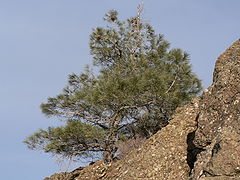
At higher altitudes and on north slopes is the widely distributed foothill pine (Pinus sabiniana). Knobcone pine (Pinus attenuata) may be found along Knobcone Pine Road in the southern part of the park. The park and nearby Black Diamond Mines Regional Preserve
Black Diamond Mines Regional Preserve
The Black Diamond Mines Regional Preserve is a 6,000-acre park located north of Mount Diablo in Contra Costa County, California under the administration of the East Bay Regional Park District. The 60 miles of trails in the Preserve cross rolling foothill terrain covered with grassland, California...
mark the northern extreme of the range of Coulter pine
Coulter Pine
The Coulter Pine or Big-cone Pine is a native of the coastal mountains of southern California and northern Baja California . Isolated groves are found as far north as the San Francisco Bay Area in Mt. Diablo State Park and Black Diamond Mines Regional Preserve...
(Pinus coulteri). This species may be seen along the Coulter Pine Trail near the north (Mitchell Canyon) entrance.
In 2005 the endangered species
Endangered species
An endangered species is a population of organisms which is at risk of becoming extinct because it is either few in numbers, or threatened by changing environmental or predation parameters...
Mount Diablo buckwheat
Mount Diablo buckwheat
Eriogonum truncatum, the Mount Diablo buckwheat, is a small pink wildflower, believed to have been extinct since 1936 until its rediscovery in 2005. The species is only known to live on Mount Diablo in Contra Costa County, northern California....
(Eriogonum truncatum), thought to be extinct since last seen in 1936, was rediscovered in a remote area of the mountain.
Wildlife
All vegetation, minerals and wildlife within the park are protected and it is illegal to remove such items or to harass any wildlife.Commonly seen animals include coyote
Coyote
The coyote , also known as the American jackal or the prairie wolf, is a species of canine found throughout North and Central America, ranging from Panama in the south, north through Mexico, the United States and Canada...
, bobcat
Bobcat
The bobcat is a North American mammal of the cat family Felidae, appearing during the Irvingtonian stage of around 1.8 million years ago . With twelve recognized subspecies, it ranges from southern Canada to northern Mexico, including most of the continental United States...
, Black-tailed Deer
Black-tailed Deer
Two forms of black-tailed deer or blacktail deer occupying coastal temperate rainforest on North America's Pacific coast are subspecies of the mule deer. They have sometimes been treated as a species, but virtually all recent authorities maintain they are subspecies...
, California Ground Squirrel
California Ground Squirrel
The California ground squirrel , is a common and easily observed ground squirrel of the western United States and the Baja California peninsula; it is common in Oregon and California and its range has relatively recently extended into Washington and northwestern Nevada...
s, Fox Squirrel
Fox Squirrel
The fox squirrel is the largest species of tree squirrel native to North America...
s and Grey Foxes; many other mammals including Mountain lions are present. It is a chief remaining refuge for the threatened Alameda Whipsnake, California red-legged frog
California Red-legged Frog
The California red-legged frog, Rana draytonii, is a moderate to large species of frog. It is known under the scientific name Rana draytonii, after being long included with the northern red-legged frog The California red-legged frog, Rana draytonii, is a moderate to large (4.4–14 cm) species...
. Less common wildlife species include the reintroduced peregrine falcon
Peregrine Falcon
The Peregrine Falcon , also known as the Peregrine, and historically as the Duck Hawk in North America, is a widespread bird of prey in the family Falconidae. A large, crow-sized falcon, it has a blue-gray back, barred white underparts, and a black head and "moustache"...
, ringtail cats, and to the east American badger
American Badger
The American badger is a North American badger, somewhat similar in appearance to the European badger. It is found in the western and central United States, northern Mexico and central Canada, as well as in certain areas of southwestern British Columbia.Their habitat is typified by open...
s, San Joaquin kit fox, roadrunners, California tiger salamander
California Tiger Salamander
The California tiger salamander is a vulnerable amphibian native to Northern California. Previously considered to be a Tiger Salamander subspecies, the California tiger salamander was recently designated a separate species again...
, and burrowing owl
Burrowing Owl
The Burrowing Owl is a tiny but long-legged owl found throughout open landscapes of North and South America. Burrowing Owls can be found in grasslands, rangelands, agricultural areas, deserts, or any other open dry area with low vegetation. They nest and roost in burrows, such as those excavated...
s. There are also exotic (non-native) animals such as the Red Fox
Red Fox
The red fox is the largest of the true foxes, as well as being the most geographically spread member of the Carnivora, being distributed across the entire northern hemisphere from the Arctic Circle to North Africa, Central America, and the steppes of Asia...
and Opossum, the latter being North America's only marsupial
Marsupial
Marsupials are an infraclass of mammals, characterized by giving birth to relatively undeveloped young. Close to 70% of the 334 extant species occur in Australia, New Guinea, and nearby islands, with the remaining 100 found in the Americas, primarily in South America, but with thirteen in Central...
.
In September and October male Tarantula
Tarantula
Tarantulas comprise a group of often hairy and often very large arachnids belonging to the family Theraphosidae, of which approximately 900 species have been identified. Some members of the same Suborder may also be called "tarantulas" in the common parlance. This article will restrict itself to...
spiders can be seen (Aphonopelma smithi
Aphonopelma smithi
Aphonopelma smithi, also known as the Bay Area Blond tarantula, is an endemic spider to Northern California, found in California interior chaparral and woodlands habitats.-Habitat:...
) as they seek a mate. These spiders are harmless unless severely provoked, and their bite is only as bad as a bee sting. More dangerous are black widow spider
Black widow spider
Latrodectus mactans, the Southern black widow, is a highly venomous species of spider in the genus Latrodectus. They are well known for the distinctive black and red coloring of the female of the species and for the fact that she will occasionally eat her mate after reproduction. The species is...
s, far less likely to be encountered in the open.
In the wintertime, between November and February, Bald Eagle
Bald Eagle
The Bald Eagle is a bird of prey found in North America. It is the national bird and symbol of the United States of America. This sea eagle has two known sub-species and forms a species pair with the White-tailed Eagle...
s and Golden Eagle
Golden Eagle
The Golden Eagle is one of the best known birds of prey in the Northern Hemisphere. Like all eagles, it belongs to the family Accipitridae. Once widespread across the Holarctic, it has disappeared from many of the more heavily populated areas...
s are present. These birds are less easily seen than many raptors; Golden Eagles, particularly, fly at high elevations. Mount Diablo is part of the Altamont Area/Diablo Range, which enjoys the largest concentration of Golden Eagles anywhere. In recent years there have been credible sightings of California Condors, which have been reintroduced at Pinnacles National Monument, located to the south in the Gilroy-Hollister area.
Of special note as potential hazards are Northern Pacific rattlesnake. While generally shy and non-threatening, one should be observant and cautious of where one steps to avoid accidentally disturbing one. They are often found warming themselves in the open (as on trails and ledges) on cool, sunny days. Other wildlife to avoid include Poison Oak, Hop Tree, fleas, ticks and mosquitoes.
There has also been an increase in the mountain lion population in the larger region and one should know how to respond if these animals are encountered. Please see the mountain lion safety tips in the Mountain lion article.
Facilities
Walnut Creek, California
Walnut Creek is an incorporated city located east of the city of Oakland. It lies in the East Bay region of the San Francisco Bay Area. While not as large as neighboring Concord, Walnut Creek serves as the business and entertainment hub for the neighboring cities within central Contra Costa...
) and Diablo Road (in Danville
Danville, California
The Town of Danville is located in the San Ramon Valley in Contra Costa County, California. It is one of the incorporated municipalities in California that uses "town" in its name instead of "city". The population was 42,039 in 2010. Danville is one of the wealthiest suburbs of Oakland and San...
). The Danville entrance is also known as Southgate. If the gate houses are not operating, park fees may be paid at the junction ranger station, where the two roads join.
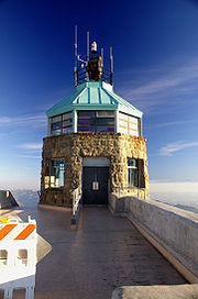
From here the road reaches the summit of the mountain, where there is a visitors center housing an observation deck and natural history exhibits. On busy days it is advisable to park at the large parking lot near the summit and take a short walk up to the summit. At this lot you may encounter hang gliders ready for launch. There is also a restroom here and at the summit.
From the elevation of the lower lot the Mary Bowerman Trail is a level wheelchair-accessible path and boardwalk with interpretive stations that extends part way around the mountain; a regular single track trail completes the loop. There are 520 miles (836.9 km) of hiking
Hiking
Hiking is an outdoor activity which consists of walking in natural environments, often in mountainous or other scenic terrain. People often hike on hiking trails. It is such a popular activity that there are numerous hiking organizations worldwide. The health benefits of different types of hiking...
and equestrian trails, some available for mountain biking
Mountain biking
Mountain biking is a sport which consists of riding bicycles off-road, often over rough terrain, using specially adapted mountain bikes. Mountain bikes share similarities with other bikes, but incorporate features designed to enhance durability and performance in rough terrain.Mountain biking can...
.
Camping
Camping
Camping is an outdoor recreational activity. The participants leave urban areas, their home region, or civilization and enjoy nature while spending one or several nights outdoors, usually at a campsite. Camping may involve the use of a tent, caravan, motorhome, cabin, a primitive structure, or no...
facilities are available within the park. There are numerous picnic sites. Pets are restricted and require proper documentation for rabies (not just a tag). Daytime visitors must exit the park by sunset except for special events. Some picnic spots may be reserved but most are available without reservation.
Alcohol is strictly forbidden in the park. Fires are allowed only during the wet season (generally December through April), and only in sanctioned fire pits. The park may be closed on windy days during the dry season due to extremely hazardous fire conditions.
Two additional entrances with parking for hikers are provided on the northwest side of the park at Mitchell Canyon and Donner Canyon. Mitchell Canyon provides easy access to Black Point and Eagle Peak. Donner Canyon provides hikers access to Eagle Peak, Mount Olympia, North Peak, and the popular Falls Trail, which features several seasonal waterfalls.
Climate
The National Weather ServiceNational Weather Service
The National Weather Service , once known as the Weather Bureau, is one of the six scientific agencies that make up the National Oceanic and Atmospheric Administration of the United States government...
maintains a weather station at Mount Diablo Junction, 2,170 feet (661 m) above sea level. The warmest month at the station is July with an average high of 85.2 °F (29.5 °C) and an average low of 59.6 °F (15.3 °C). The coolest month is January with an average high of 55.6 °F (13.1 °C) and an average low of 39.3° (4.1 °C). The highest temperature recorded there was 111 °F (43.9 °C) on July 15, 1972. The lowest temperature on record was 14 °F (-10 °C) on February 6, 1989, and on December 14, 1990. (The San Francisco Chronicle
San Francisco Chronicle
thumb|right|upright|The Chronicle Building following the [[1906 San Francisco earthquake|1906 earthquake]] and fireThe San Francisco Chronicle is a newspaper serving primarily the San Francisco Bay Area of the U.S. state of California, but distributed throughout Northern and Central California,...
reported that the temperature dropped to 10 °F (-12.2 °C) at the summit on January 21, 1962.) Temperatures reach 90 °F (32.2 °C) or higher on an average of 36.0 days each year and 100 °F (37.8 °C) or higher on 3.3 days each year. Lows of 32 °F (0 °C) or lower occur on an average of 15.4 days annually.
Annual precipitation averages 23.96 inches (60.9 cm). The most precipitation recorded in a month was 13.54 inches (34.4 cm) in February 1998. The greatest 24-hour precipitation was 5.02 inches (12.8 cm) on January 21, 1972. The average annual days with measurable precipitation is 65.3 days.
Snowfall at Mount Diablo Junction averages 1.2 inches (3 cm) each year. Prior to 2009, the most snowfall observed in a month was 17 inches (43.2 cm) in April 1975; that same month saw 6 inches (15.2 cm) in one day (April 4, 1975). The greatest snow depth was 3 inches (7.6 cm) on January 27, 1972. Measurable snowfall does not occur every year, so the annual average days with measurable snowfall is only .5 days. Snow is more common in the upper reaches of the mountain. On December 7, 2009 Mount Diablo received a rare snow event of 18 inches (45.7 cm), receiving more in one day than what it normally receives in one year.
Data-collecting note
It is important to note that the weather station is positioned at only about 55 percent of the mountain's height, and temperature and snow levels are notably different at the upper reaches of the mountain, where more snow and lower temperatures may have occurred, but simply not have been recorded. Nearby Bay Area mountains, like Mount HamiltonMount Hamilton (California)
Mount Hamilton is a mountain in California's Diablo Range, in Santa Clara County, California. Mount Hamilton, at is the tallest mountain overlooking Silicon Valley, and is the site of Lick Observatory, the first permanently occupied mountain-top observatory. The various summits along its...
, have their weather stations virtually at the maximum height of the mountain. This is why recorded snow levels on Mount Hamilton are much higher than the ones recorded at Mount Diablo Junction, even though the difference in height of Mount Hamilton and Mount Diablo is only about 400 foot.
Three conditions are measured at the actual summit, however: wind speed, wind direction and temperature; and are available by an automatic telephone voice response system. Recorded information concerning gate open times, road and pet restrictions, and events is available at another number. These numbers are posted at the park website.
Mount Diablo art and literature
University of California, Berkeley
The University of California, Berkeley , is a teaching and research university established in 1868 and located in Berkeley, California, USA...
, the California College of Arts, the actions of the organizations Save Mount Diablo and the Mount Diablo Interpretive Association, and area art centers, galleries, and museums. In modern times Mount Diablo art has been most strongly represented in plein aire painting, especially the group Artists for Action, and photography.
Representative work includes books and articles by classical writers such as William Brewer, Richard Henry Dana, Jr.
Richard Henry Dana, Jr.
Richard Henry Dana Jr. was an American lawyer and politician from Massachusetts, a descendant of an eminent colonial family who gained renown as the author of the American classic, the memoir Two Years Before the Mast...
, Alexandre Dumas, père
Alexandre Dumas, père
Alexandre Dumas, , born Dumas Davy de la Pailleterie was a French writer, best known for his historical novels of high adventure which have made him one of the most widely read French authors in the world...
, Bret Harte
Bret Harte
Francis Bret Harte was an American author and poet, best remembered for his accounts of pioneering life in California.- Life and career :...
, and the Reverend Thomas Starr King
Thomas Starr King
Thomas Starr King was an American Unitarian and Universalist minister, influential in California politics during the American Civil War. Starr King spoke zealously in favor of the Union and was credited by Abraham Lincoln with preventing California from becoming a separate republic...
, and modern ones such as Mark Allen Cunningham. Poets whose work features the mountain include Philip Lamantia
Philip Lamantia
Philip Lamantia was an American poet and lecturer. Lamantia's visionary poems were ecstatic, terror-filled, and erotic which explored the subconscious world of dreams and linked it to the experience of daily life.-Biography:...
and Helen Pinkerton.
Early painters include Thomas Almond Ayres, Eugene Camerer, W. H. Dougal, Eduard Hildebrandt, Charles Hittell, Edward Jump, William Keith, John Ross Key, Charles Koppel, Edward Lehman, Pascal Loomis, Henry Miller, Joseph Warren Revere, through Clarkson Dye and others, to modern painters such as Robert Becker, Frank J. Bette, Ruth Breve, Betty Boggess Lathrap, Paul Carey, Bob Chapla, Mary Lou Correia, Ellen Curtis, Pam Della, Susan Dennis, Warren Dreher, John Finger, Pam Glover, JoAnn Hanna, Peg Humphreys, Don Irwin, Jeanne Kapp, Geri Keary, Chris Kent, Paul Kratter, Eunice Kritscher, Fred Martin, Cathy Moloney, Shirley Nootbaar, Charlotte Panton, Greg Piatt, Kenneth Potter, Robin Purcell, Ocean Quigley, Don Reich, Mary Silverwood, Barbara Stanton, Bruce Stangeland, Marty Stanley, and even the recognized comic book painter Dan Brereton.
Photographers include Ansel Adams, Cleet Carlton, Alfred A. Hart, Scott Hein, Stephen Joseph, Don Paulson, Brad Perks, Robert Picker, Richard Rollins, David Sanger, Michael Sewell and Bob Walker.
The mountain has inspired musical artists ranging from the Kronos Quartet
Kronos Quartet
Kronos Quartet is a string quartet founded by violinist David Harrington in 1973 in Seattle, Washington. Since 1978, the quartet has been based in San Francisco, California. The longest-running combination of performers had Harrington and John Sherba on violin, Hank Dutt on viola, and Joan...
to commissioned works by the California Symphony.
The mountain's name is the source for the "Devils" part of the name of the Blue Devils Drum and Bugle Corps
Blue Devils Drum and Bugle Corps
The Blue Devils Drum and Bugle Corps is a World Class drum and bugle corps based in Concord, California and founded in 1957 as a Drum and Bell corps, and is a member corps of Drum Corps International...
, a 14 time Drum Corps International world champion corps, founded and based in Concord, California since 1957.
David Brevik, head of Blizzard North, got the idea for the popular computer games Diablo and Diablo II from Mt. Diablo while living nearby.
Famous residents
Mount Diablo has been the home of a number of famous residents.James "Grizzly" Adams was a frequent visitor and resident on Mount Diablo in the mid-1850s.
Robert Walter "Bob" Jones, the first professional baseball player from Contra Costa County, was born in the "Jones House" in Irish Canyon in 1889, a current acquisition project of Save Mount Diablo.
The Mount Diablo Ranch, or Diablo Ranch, was successively owned by Robert Noble Burgess (b. 1878 - d. 1965), who founded the community of Diablo and built the mountain's first auto roads, and millionaire Walter Paul Frick (aka W.P. Frick, b. 1875 - d. 1937), who lived in Diablo and was important in the creation of the State Park in 1931, including sale of six of the first seven parcels for the new park.
Jazz pianist Dave Brubeck
Dave Brubeck
David Warren "Dave" Brubeck is an American jazz pianist. He has written a number of jazz standards, including "In Your Own Sweet Way" and "The Duke". Brubeck's style ranges from refined to bombastic, reflecting his mother's attempts at classical training and his improvisational skills...
grew up on Brubeck Ranch near the park's Northgate entrance.
The area for the 6500 acres (2,630 ha) Blackhawk Farm, including the mountain's southern Black Hills, was acquired from Burgess and created by Ansel Mills Easton, the namesake uncle of photographer Ansel Adams. Eventually nearly two-thirds of the farm was added to Mount Diablo State Park. The remainder was developed as the community of Blackhawk
Blackhawk, California
Blackhawk is an unincorporated master planned community and census-designated place located in Contra Costa County, California, east of Danville and Oakland. The ZIP Code is 94506. The community is inside area code 925.-Blackhawk Ranch, 1917 to 1979:...
by resident developer Ken Behring
Ken Behring
Kenneth Eugene Behring is a real-estate developer, former owner of the Seattle Seahawks football team, and philanthropist.-Early years:...
.
Legends and folklore
Mount Diablo has long been the site of numerous reports pertaining to cryptozoologyCryptozoology
Cryptozoology refers to the search for animals whose existence has not been proven...
, hauntings
Ghost
In traditional belief and fiction, a ghost is the soul or spirit of a deceased person or animal that can appear, in visible form or other manifestation, to the living. Descriptions of the apparition of ghosts vary widely from an invisible presence to translucent or barely visible wispy shapes, to...
, mysterious lights
Will-o'-the-wisp
A will-o'-the-wisp or ignis fatuus , also called a "will-o'-wisp", "jack-o'-lantern" , "hinkypunk", "corpse candle", "ghost-light", "spook-light", "fairy light", "friar's lantern", "hobby lantern", "ghost orb", or simply "wisp", is a ghostly light or lights sometimes seen at night or twilight over...
, and various other Fortean phenomena (it is rumored that the name "Mount Diablo" is derived from the propensity for such weird events to be alleged at, or in the immediate vicinity, of the mountain). Phantom
Phantom cat
Phantom cats, also known as Alien Big Cats , are large felines, such as jaguars or cougars, which have been purported to appear in regions outside their indigenous range...
black "panthers
Black panther
A black panther is typically a melanistic color variant of any of several species of larger cat. Wild black panthers in Latin America are black jaguars , in Asia and Africa they are black leopards , and in North America they may be black jaguars or possibly black cougars A black panther is...
" are seen with unusual frequency on the slopes of the mountain, as well as at the "Devil's Hole" region of the Las Trampas Regional Wilderness
Las Trampas Regional Wilderness
Las Trampas Regional Wilderness is a regional park located in Alameda and Contra Costa counties in Northern California. It is part of the East Bay Regional Park District. It consists of two long, hilly ridges flanking a narrow valley which contains a horse stable and visitor parking. Some of the...
. As early as 1806, General Mariano Guadalupe Vallejo
Mariano Guadalupe Vallejo
Mariano Guadalupe Vallejo was a Californian military commander, politician, and rancher. He was born a subject of Spain, performed his military duties as an officer of Mexico, and shaped the transition of California from a Mexican district to an American state...
reported an encounter with a flying, spectral apparition, while engaged in military operations against the Bolgones band of the Bay Miwok
Bay Miwok
The Bay Miwok were a cultural and linguistic group of Miwok, a Native American people in Northern California who lived in Contra Costa County. They joined the Franciscan mission system during the early nineteenth century, suffered a devastating population decline, and lost their language as they...
tribe. In 1873, a live frog
Frog
Frogs are amphibians in the order Anura , formerly referred to as Salientia . Most frogs are characterized by a short body, webbed digits , protruding eyes and the absence of a tail...
was said to be found within a slab of limestone
Limestone
Limestone is a sedimentary rock composed largely of the minerals calcite and aragonite, which are different crystal forms of calcium carbonate . Many limestones are composed from skeletal fragments of marine organisms such as coral or foraminifera....
at a mine
Mining
Mining is the extraction of valuable minerals or other geological materials from the earth, from an ore body, vein or seam. The term also includes the removal of soil. Materials recovered by mining include base metals, precious metals, iron, uranium, coal, diamonds, limestone, oil shale, rock...
on Mount Diablo.
Events
Every year on December 7 the aircraft beacon atop the summit building is illuminated from sunset to dawn. A ceremony memorializing the attack on Pearl HarborAttack on Pearl Harbor
The attack on Pearl Harbor was a surprise military strike conducted by the Imperial Japanese Navy against the United States naval base at Pearl Harbor, Hawaii, on the morning of December 7, 1941...
on this day in 1941 is held at the summit, with some of the few remaining survivors who are present. The public is welcome and visitors on this day should enter the park before 4:00 PM. General parking will be at the lower lot on these days, with a short uphill walk by trail or road to the summit. Visitors may leave later than usual — this is one of the few opportunities to view the sunset from the peak, weather permitting, without an overnight stay.
Under cloudless conditions, more interesting than the sunset itself is the view of the progression of the mountain's shadow across the California Central Valley
California Central Valley
California's Central Valley is a large, flat valley that dominates the central portion of California. It is home to California's most productive agricultural efforts. The valley stretches approximately from northwest to southeast inland and parallel to the Pacific Ocean coast. Its northern half is...
to the distant Sierra Nevada, finally appearing for a few moments above the horizon as a shadow in the post-sunset sky glow.
In April 1946, an Army C-45 transport plane crashed on the north side of the mountain, killing the pilot and co-pilot.
Save Mount Diablo sponsors many spring and fall schedules of events on the mountain, Spring on Diablo and Autumn on Diablo, as well as many other special events, including its anniversary event, Moonlight on the Mountain; Four Days Diablo, a trip on the Diablo Trail; the Mount Diablo Challenge, an annual hill climb to the summit with more than 1,100 cyclists each October; and the Mount Diablo Trail Adventure, combined 10k and half-marathon hikes and runs.
The park is popular in winter, when Bay Area residents can enjoy the rare experience of snowfall on the mountain. Snow occurs from the lower reaches of the park all the way to the peak, as was the case in February 2001 and February and March 2006. On Friday, March 10, 2006, an extremely cold storm moved into the region from the Gulf of Alaska
Gulf of Alaska
The Gulf of Alaska is an arm of the Pacific Ocean defined by the curve of the southern coast of Alaska, stretching from the Alaska Peninsula and Kodiak Island in the west to the Alexander Archipelago in the east, where Glacier Bay and the Inside Passage are found.The entire shoreline of the Gulf is...
, and noticeable amounts of snow fell in all regions of the Bay Area above 500 feet (152 m). The summit of the mountain received around six inches (15 cm) of snow at its peak, and the access roads were closed to automobiles at the 3,000 feet (914 m) mark due to the hazardous icy conditions above.
Occasionally there will be public access to astronomical observations made by a local astronomy club. This club has been allocated a small parcel on the mountain and is developing a permanent observatory at this location. The instrument to be installed will have digital-imaging capabilities and visitors will be able to take home an astronomical image that they may display on their home computer system.
Mount Diablo Challenge bicycle race
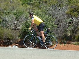
Course record
The course record for the Mount Diablo climb currently stands at 43 minutes, 33 seconds, set on Oct 5, 2008, by Nate English (ZteaM) 4 days after breaking his thumb in a bike accident. He broke the 44 minutes, 58 seconds record, set in 2004 by former professional cyclist Greg Drake (Webcor Cycling Team) of Redwood City, California. The previous course record was set by former professional cyclist Mike Engleman (Coors Light Pro Cycling Team) in 1990 with a time of 45 minutes, 20 seconds.The fastest woman's time recorded at the Mount Diablo climb was set in 2008 by Flavia Oliveira (51 minutes, 40 seconds). The following year, Flavia traveled to Europe to race professionally for Michela Fanini Record Rox based in Lucca, Italy.
Popular culture
Mount Chiliad, the mountain featured in the video game Grand Theft Auto: San AndreasGrand Theft Auto: San Andreas
Grand Theft Auto: San Andreas is a 2004 open world action video game developed by British games developer Rockstar North and published by Rockstar Games. It is the third 3D game in the Grand Theft Auto video game franchise, the fifth original console release and eighth game overall...
, is based on Mount Diablo.
Mount Diablo is also used in the Rick Riordan
Rick Riordan
Richard Russell "Rick" Riordan, Jr. is an American author best known for writing the Percy Jackson & the Olympians series. He also wrote the Tres Navarre mystery series for adults and helped to edit Demigods and Monsters, a collection of essays on the topic of his Percy Jackson series...
book The Lost Hero
The Lost Hero
The Lost Hero is a 2010 fantasy-adventure novel written by Rick Riordan and is based on Greek and Roman mythology. It is the first book in the series The Heroes of Olympus, the next series about Camp Half-Blood. It was preceded by the Percy Jackson & the Olympians series, which focused solely on...
as the home of the giant Enceladus
Enceladus (mythology)
In Greek mythology, Enceladus was one of the Gigantes, the enormous children of Gaia fertilized by the blood of castrated Uranus...
.
Mount Diablo is referenced in the title and lyrics of the song "Mt. Diablo" by the pop-punk band The Story So Far
The Story So Far
The Story So Far is the third album by the Tewkesbury ska punk band Spunge. It was released on 26 August 2002 on the B-Unique Records label and recorded at two studios, Sawmills and Jacobs...
.
See also
- Diablo, CaliforniaDiablo, CaliforniaDiablo is a census-designated place in Contra Costa County, California, United States. The population was 1,158 at the 2010 census. It is located east-northeast of Danville...
- List of highest points in California by county
- List of summits in the San Francisco Bay Area
External links
- Mount Diablo and Mount Diablo 2. Panoramic views from the summit of Mount Diablo. Mediacom.