

Longdendale
Encyclopedia
Glossop
Glossop is a market town within the Borough of High Peak in Derbyshire, England. It lies on the Glossop Brook, a tributary of the River Etherow, about east of the city of Manchester, west of the city of Sheffield. Glossop is situated near Derbyshire's county borders with Cheshire, Greater...
and south east of Holmfirth
Holmfirth
Holmfirth is a small town located on the A6024 Woodhead Road in the Holme Valley, within the Metropolitan Borough of Kirklees, West Yorkshire, England. Centred upon the confluence of the Holme and Ribble rivers, Holmfirth is south of Huddersfield and from Glossop. It mostly consists of...
. The name means "long wooded valley".
Geography
The eastern part of the valley is in the non-metropolitan county of DerbyshireDerbyshire
Derbyshire is a county in the East Midlands of England. A substantial portion of the Peak District National Park lies within Derbyshire. The northern part of Derbyshire overlaps with the Pennines, a famous chain of hills and mountains. The county contains within its boundary of approx...
and includes the village of Tintwistle
Tintwistle
Tintwistle is a village and civil parish in the High Peak district of the non-metropolitan county of Derbyshire, England. According to the 2001 census the parish had a population of 1,401. The village is just north of Glossop at the lower end of Longdendale Valley...
and, further east, part of the Peak District
Peak District
The Peak District is an upland area in central and northern England, lying mainly in northern Derbyshire, but also covering parts of Cheshire, Greater Manchester, Staffordshire, and South and West Yorkshire....
National Park, with the last half mile or so falling into the metropolitan borough
Metropolitan borough
A metropolitan borough is a type of local government district in England, and is a subdivision of a metropolitan county. Created in 1974 by the Local Government Act 1972, metropolitan boroughs are defined in English law as metropolitan districts, however all of them have been granted or regranted...
of Barnsley
Barnsley
Barnsley is a town in South Yorkshire, England. It lies on the River Dearne, north of the city of Sheffield, south of Leeds and west of Doncaster. Barnsley is surrounded by several smaller settlements which together form the Metropolitan Borough of Barnsley, of which Barnsley is the largest and...
. The western part of the valley, including the villages of Broadbottom
Broadbottom
Broadbottom is a suburban village within the Metropolitan Borough of Tameside in Greater Manchester, England. It lies within the ancient county boundaries of Cheshire, by the River Etherow, on Greater Manchester's border with Derbyshire.-Description:...
, Mottram in Longdendale
Mottram in Longdendale
Mottram in Longdendale is an unparished village within the Metropolitan Borough of Tameside, in Greater Manchester, England. It lies in the valley of Longdendale, on the border with Derbyshire and close to the Peak District neighbouring Broadbottom and Hattersley. Mottram in Longdendale Parish was...
and Hollingworth
Hollingworth
Hollingworth is a village within the Metropolitan Borough of Tameside, in Greater Manchester, England. It is about twelve miles east of Manchester on the Derbyshire border at Glossop...
is administered by the metropolitan borough
Metropolitan borough
A metropolitan borough is a type of local government district in England, and is a subdivision of a metropolitan county. Created in 1974 by the Local Government Act 1972, metropolitan boroughs are defined in English law as metropolitan districts, however all of them have been granted or regranted...
of Tameside
Tameside
The Metropolitan Borough of Tameside is a metropolitan borough of Greater Manchester in North West England. It is named after the River Tame which flows through the borough and spans the towns of Ashton-under-Lyne, Audenshaw, Denton, Droylsden, Dukinfield, Hyde, Mossley and Stalybridge. Its western...
in the metropolitan county
Metropolitan county
The metropolitan counties are a type of county-level administrative division of England. There are six metropolitan counties, which each cover large urban areas, typically with populations of 1.2 to 2.8 million...
of Greater Manchester
Greater Manchester
Greater Manchester is a metropolitan county in North West England, with a population of 2.6 million. It encompasses one of the largest metropolitan areas in the United Kingdom and comprises ten metropolitan boroughs: Bolton, Bury, Oldham, Rochdale, Stockport, Tameside, Trafford, Wigan, and the...
. The whole of Longdendale forms the easternmost extension of the lands which lie within the historic boundaries
Historic counties of England
The historic counties of England are subdivisions of England established for administration by the Normans and in most cases based on earlier Anglo-Saxon kingdoms and shires...
of the county palatine
County palatine
A county palatine or palatinate is an area ruled by an hereditary nobleman possessing special authority and autonomy from the rest of a kingdom or empire. The name derives from the Latin adjective palatinus, "relating to the palace", from the noun palatium, "palace"...
of Chester
Cheshire
Cheshire is a ceremonial county in North West England. Cheshire's county town is the city of Chester, although its largest town is Warrington. Other major towns include Widnes, Congleton, Crewe, Ellesmere Port, Runcorn, Macclesfield, Winsford, Northwich, and Wilmslow...
.
The River Etherow
River Etherow
The River Etherow is a river in northern England, and a tributary of the River Goyt. Although now passing through South Yorkshire, Derbyshire and Greater Manchester, it historically formed the ancient county boundary between Cheshire and Derbyshire. The upper valley is known as Longdendale...
, a tributary
Tributary
A tributary or affluent is a stream or river that flows into a main stem river or a lake. A tributary does not flow directly into a sea or ocean...
of the River Mersey
River Mersey
The River Mersey is a river in North West England. It is around long, stretching from Stockport, Greater Manchester, and ending at Liverpool Bay, Merseyside. For centuries, it formed part of the ancient county divide between Lancashire and Cheshire....
, rises south of Holmfirth
Holmfirth
Holmfirth is a small town located on the A6024 Woodhead Road in the Holme Valley, within the Metropolitan Borough of Kirklees, West Yorkshire, England. Centred upon the confluence of the Holme and Ribble rivers, Holmfirth is south of Huddersfield and from Glossop. It mostly consists of...
and then flows through a chain of six reservoirs known as the Longdendale Chain
Longdendale Chain
The Longdendale Chain is a sequence of six reservoirs on the River Etherow in the valley of Longdendale, in northern Derbyshire. They were constructed between 1848 and 1884 to a design by John Frederick Bateman to supply the growing population of Manchester and Salford with fresh water.The top...
: Arnfield Reservoir
Arnfield Reservoir
Arnfield Reservoir is a man-made lake in Longdendale in north Derbyshire. It was constructed in 1854 as part of the Longdendale chain to supply water from the River Etherow to the urban areas of Greater Manchester. Unlike the other reservoirs in the chain, Arnfield and Hollingworth Reservoir are...
, Bottoms Reservoir
Bottoms Reservoir, Derbyshire
Bottoms Reservoir is a man-made lake in Longdendale in north Derbyshire, England. It was constructed between 1865 and 1877, by John Frederick Bateman as part of the Longdendale chain to supply water from the River Etherow to the urban areas of Greater Manchester...
, Valehouse Reservoir
Valehouse Reservoir
Valehouse Reservoir is a man-made lake in Longdendale in north Derbyshire. It was built between 1865 and 1869 as part of the Longdendale chain, which was built to supply water from the River Etherow to the urban areas of Greater Manchester while maintaining a constant flow into the river...
, Rhodeswood Reservoir
Rhodeswood Reservoir
Rhodeswood Reservoir is a man-made lake in Longdendale in north Derbyshire. It was constructed by John Frederick Bateman between 1849 and June 1855 as part of the Longdendale chain to supply water from the River Etherow to the urban areas of Greater Manchester...
, Torside Reservoir
Torside Reservoir
Torside Reservoir is the largest man-made lake in Longdendale in north Derbyshire. It was constructed by John Frederick Bateman between April 1849 and July 1864 as part of the Longdendale chain to supply water from the River Etherow to the urban areas of Greater Manchester.The Manchester...
and Woodhead Reservoir
Woodhead Reservoir
Woodhead reservoir is a man-made lake near the hamlet of Woodhead in Longdendale in north Derbyshire. It was constructed by John Frederick Bateman between 1847 and June 1877 as part of the Longdendale chain to supply water from the River Etherow to the urban areas of Greater Manchester...
. There was a seventh reservoir at Hollingworth
Hollingworth
Hollingworth is a village within the Metropolitan Borough of Tameside, in Greater Manchester, England. It is about twelve miles east of Manchester on the Derbyshire border at Glossop...
, but it has now been abandoned.
Feudal estates
The lordship of Longdendale was an ancient feudal estate encompassing the medieval manorsManorialism
Manorialism, an essential element of feudal society, was the organizing principle of rural economy that originated in the villa system of the Late Roman Empire, was widely practiced in medieval western and parts of central Europe, and was slowly replaced by the advent of a money-based market...
of Godley, Hattersley
Hattersley
Hattersley is a residential area within the Metropolitan Borough of Tameside, in Greater Manchester, England. It is to the east of Hyde and 6 miles west of the Peak District National Park....
, Hollingworth
Hollingworth
Hollingworth is a village within the Metropolitan Borough of Tameside, in Greater Manchester, England. It is about twelve miles east of Manchester on the Derbyshire border at Glossop...
, Matley
Matley
Matley is a semi-rural area of Greater Manchester, England. It is located in the Metropolitan Borough of Tameside between the towns of Stalybridge, Hyde and Dukinfield. Matley was a township of Mottram in Longdendale, one of the eight ancient parishes of the Macclesfield Hundred of Cheshire. Under...
, Mottram
Mottram in Longdendale
Mottram in Longdendale is an unparished village within the Metropolitan Borough of Tameside, in Greater Manchester, England. It lies in the valley of Longdendale, on the border with Derbyshire and close to the Peak District neighbouring Broadbottom and Hattersley. Mottram in Longdendale Parish was...
, Newton, Staley
Stalybridge
Stalybridge is a town in the Metropolitan Borough of Tameside in Greater Manchester, England, with a population of 22,568. Historically a part of Cheshire, it is east of Manchester city centre and northwest of Glossop. With the construction of a cotton mill in 1776, Stalybridge became one of...
, Tintwistle
Tintwistle
Tintwistle is a village and civil parish in the High Peak district of the non-metropolitan county of Derbyshire, England. According to the 2001 census the parish had a population of 1,401. The village is just north of Glossop at the lower end of Longdendale Valley...
and Werneth
Werneth, Greater Manchester
Werneth is an area of Oldham, in Greater Manchester, England. It is west-southwest of Oldham's commercial centre and one of Oldham's most ancient localities.-History:...
. The lordship was created by the Earl of Chester
Earl of Chester
The Earldom of Chester was one of the most powerful earldoms in medieval England. Since 1301 the title has generally been granted to heirs-apparent to the English throne, and from the late 14th century it has been given only in conjunction with that of Prince of Wales.- Honour of Chester :The...
in the late twelfth century; William de Neville was the first lord of Longdendale, as appointed by the Earl of Chester. Buckton Castle
Buckton Castle
Buckton Castle is a medieval ringwork near Carrbrook, Stalybridge, England. It is listed as a Scheduled Ancient Monument due to its proximity to the Buckton Vale Quarry. The castle is oval, with a stone curtain wall wide, surrounded by a ditch wide and deep. Buckton Castle was probably...
, near Carrbrook
Carrbrook
Carrbrook is an area in the east of Stalybridge, in Greater Manchester, England. The area still has many seventeenth and eighteenth century buildings. Much of the late-nineteenth and early-twentieth century village was built during the industrial boom brought by the printworks. Modern Housing...
, was probably built by William de Neville in the late twelfth century and was also probably the centre of lordship of Longdendale as it is the only castle within the lordship. One of the privileges of the lordship was to carry out trial by combat. The lordship of Longdendale was passed from de Neville to his son in law, Thomas de Burgh, in 1211 on his death. The lordship reverted to the control of the crown in 1357, and remained under crown control until 1374. The lordship was given to Matilda Lovell and the Lovells controlled Longdendale until 1465 when control again reverted to the crown. The lordship was granted to Sir William Stanley in 1489, however the lordship once again reverted to the crown when Stanley was executed in 1495 as a supporter of Perkin Warbeck
Perkin Warbeck
Perkin Warbeck was a pretender to the English throne during the reign of King Henry VII of England. By claiming to be Richard of Shrewsbury, Duke of York, the younger son of King Edward IV, one of the Princes in the Tower, Warbeck was a significant threat to the newly established Tudor Dynasty,...
. In 1554 the lordship was granted to Richard Wilbraham. Tollemache family inherited lordship of Longdendale from the Wilbrahams in the 1690s. It was part of the Hundred of Macclesfield. An estate survey, or 'Extent' of the lordship for 1360 was published by the Record Society of Lancashire and Cheshire in July 2005.
Salt trade
Packhorse
.A packhorse or pack horse refers generally to an equid such as a horse, mule, donkey or pony used for carrying goods on their backs, usually carried in sidebags or panniers. Typically packhorses are used to cross difficult terrain, where the absence of roads prevents the use of wheeled vehicles. ...
route called a saltway was maintained from the Middle Ages onwards for the purpose of allowing the export of salt from the Cheshire
Cheshire
Cheshire is a ceremonial county in North West England. Cheshire's county town is the city of Chester, although its largest town is Warrington. Other major towns include Widnes, Congleton, Crewe, Ellesmere Port, Runcorn, Macclesfield, Winsford, Northwich, and Wilmslow...
wiches of Nantwich
Nantwich
Nantwich is a market town and civil parish in the Borough of Cheshire East and the ceremonial county of Cheshire, England. The town gives its name to the parliamentary constituency of Crewe and Nantwich...
, Northwich
Northwich
Northwich is a town and civil parish in the unitary authority of Cheshire West and Chester and the ceremonial county of Cheshire, England. It lies in the heart of the Cheshire Plain, at the confluence of the rivers Weaver and Dane...
and Middlewich
Middlewich
Middlewich is a market town in the unitary authority of Cheshire East and the ceremonial county of Cheshire, England. It is east of the city of Chester, east of Winsford, southeast of Northwich and northwest of Sandbach....
across the Pennines
Pennines
The Pennines are a low-rising mountain range, separating the North West of England from Yorkshire and the North East.Often described as the "backbone of England", they form a more-or-less continuous range stretching from the Peak District in Derbyshire, around the northern and eastern edges of...
. The passing trade brought prosperity to settlements along the route. The importance of the salt trade along such saltways is shown by surviving placenames; for example Salter's Brook is where the saltway forked, with one route leading to Wakefield
Wakefield
Wakefield is the main settlement and administrative centre of the City of Wakefield, a metropolitan district of West Yorkshire, England. Located by the River Calder on the eastern edge of the Pennines, the urban area is and had a population of 76,886 in 2001....
and another to Barnsley
Barnsley
Barnsley is a town in South Yorkshire, England. It lies on the River Dearne, north of the city of Sheffield, south of Leeds and west of Doncaster. Barnsley is surrounded by several smaller settlements which together form the Metropolitan Borough of Barnsley, of which Barnsley is the largest and...
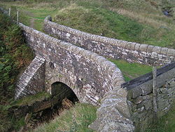
. The stone Lady Shaw Bridge still exists at this point, as do the ruins of an old inn. The bridge is just wide enough for a packhorse, though it is suspected that the bridge may have originally been wider, and deliberately narrowed when the Saltersbrook turnpike was built to prevent vehicles bypassing the toll barrier.
Turnpike road
The turnpikeTurnpike trust
Turnpike trusts in the United Kingdom were bodies set up by individual Acts of Parliament, with powers to collect road tolls for maintaining the principal highways in Britain from the 17th but especially during the 18th and 19th centuries...
road from Manchester to Saltersbrook connected to further turnpikes for Yorkshire
Yorkshire
Yorkshire is a historic county of northern England and the largest in the United Kingdom. Because of its great size in comparison to other English counties, functions have been increasingly undertaken over time by its subdivisions, which have also been subject to periodic reform...
destinations and was built in the mid-eighteenth century, based on the older saltway route.
The reservoirs
The Longdendale catchment exceeds 30 square miles (77.7 km²) and has an annual rainfall of 52.5 inches (1,333.5 mm). The civil engineer John Frederick BatemanJohn Frederick Bateman
John Frederick Bateman was an English civil engineer whose work formed the basis of the modern United Kingdom water supply industry. For over 50 years from 1835 he designed and constructed reservoirs and waterworks. His largest project was the system that supplied Manchester with much of its...
, recognised the potential and conceived a plan to deliver this water to Manchester and Salford, while still maintaining the flow in the River Etherow that was needed to power the mills of Tintwistle
Tintwistle
Tintwistle is a village and civil parish in the High Peak district of the non-metropolitan county of Derbyshire, England. According to the 2001 census the parish had a population of 1,401. The village is just north of Glossop at the lower end of Longdendale Valley...
and Glossop
Glossop
Glossop is a market town within the Borough of High Peak in Derbyshire, England. It lies on the Glossop Brook, a tributary of the River Etherow, about east of the city of Manchester, west of the city of Sheffield. Glossop is situated near Derbyshire's county borders with Cheshire, Greater...
. The six reservoirs have a capacity of 4,200 million gallons.. A tunnel was built at a depth of 200 feet (61 m) to carry the water from Longdendale into the valley of the River Tame
River Tame, Greater Manchester
The River Tame flows through Greater Manchester, England.-Source:The Tame rises on Denshaw Moor in Greater Manchester, close to the border with West Yorkshire but within the historic West Riding of Yorkshire.-Course:...
.An Act of Parliament
Act of Parliament
An Act of Parliament is a statute enacted as primary legislation by a national or sub-national parliament. In the Republic of Ireland the term Act of the Oireachtas is used, and in the United States the term Act of Congress is used.In Commonwealth countries, the term is used both in a narrow...
(10 Victoria Cap.cciii) (9 July 1847) was passed to allow the land to be acquired and construction to commence.
The railway
The first railway line between ManchesterManchester
Manchester is a city and metropolitan borough in Greater Manchester, England. According to the Office for National Statistics, the 2010 mid-year population estimate for Manchester was 498,800. Manchester lies within one of the UK's largest metropolitan areas, the metropolitan county of Greater...
and Sheffield
Sheffield
Sheffield is a city and metropolitan borough of South Yorkshire, England. Its name derives from the River Sheaf, which runs through the city. Historically a part of the West Riding of Yorkshire, and with some of its southern suburbs annexed from Derbyshire, the city has grown from its largely...
was constructed between 1839 and 1845 on the south side of the reservoir chain by 1,500 navvies of whom many died and most suffered illness. The three-mile-long double Woodhead Tunnel
Woodhead Tunnel
The Woodhead Tunnels are three parallel trans-Pennine 3-mile long railway tunnels on the Woodhead Line, a former major rail link from Manchester to Sheffield in northern England...
was, for a time, the longest tunnel in the country. It was replaced by a single, larger tunnel in 1954. The first tunnel was subsequently used by CEGB
CEGB
The Central Electricity Generating Board was the cornerstone of the British electricity industry for almost 40 years; from 1957, to privatisation in the 1990s....
to reroute the main high-voltage link up the valley and through the National Park underground. The railway line ceased to be economical, and in 1970 the passenger service ceased, followed in 1981 by the freight service. The passenger service was adversely affected by the requirement to keep the Hope Valley line open, whilst the freight service was affected by the falloff in Trans-Pennine coal traffic. The track was lifted in 1986. There have been plans to re-open the railway at various times since it was closed, but none have gained planning approval.
Administrative change
Hollingworth and Mottram were part of the Longdendale urban districtUrban district
In the England, Wales and Ireland, an urban district was a type of local government district that covered an urbanised area. Urban districts had an elected Urban District Council , which shared local government responsibilities with a county council....
in the administrative county
Administrative county
An administrative county was an administrative division in England and Wales and Ireland used for the purposes of local government. They are now abolished, although in Northern Ireland their former areas are used as the basis for lieutenancy....
of Cheshire from 1936. In 1974 the district was absorbed by Tameside metropolitan borough.
Walking and cycling
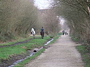
Longdendale Trail
Longdendale Trail is an English long-distance trail which follows the alignment of the former Woodhead railway line which used to run between Manchester and Sheffield...
constructed along its route. It is now part of the Trans-Pennine Trail (Sustrans
Sustrans
Sustrans is a British charity to promote sustainable transport. The charity is currently working on a number of practical projects to encourage people to walk, cycle and use public transport, to give people the choice of "travelling in ways that benefit their health and the environment"...
National Cycle Route 62) which, in its turn, is part of the 2000-mile European walking route E8
European walking route E8
The E8 European long distance path or E8 path is one of the European long-distance paths, leading 4700km across Europe, from Cork in Ireland to Istanbul in Turkey....
from Liverpool to Istanbul. The Pennine Way
Pennine Way
The Pennine Way is a National Trail in England. The trail runs from Edale, in the northern Derbyshire Peak District, north through the Yorkshire Dales and the Northumberland National Park and ends at Kirk Yetholm, just inside the Scottish border. The path runs along the Pennine hills, sometimes...
crosses Longdendale, descending from Bleaklow
Bleaklow
Bleaklow is a high, largely peat covered, gritstone moorland, just north of Kinder Scout, across the Snake Pass , in the Derbyshire High Peak near the town of Glossop...
to the south and ascending Black Hill
Black Hill (Peak District)
Black Hill is a hill in the Peak District, England.It used to be the highest point in Cheshire, but now lies on the border between the boroughs of Kirklees in West Yorkshire and High Peak in Derbyshire, reaching above sea level....
to the north. The youth hostel
YHA
YHA may refer to:* YHA Australia, a youth hostel association in Australia* Youth Hostels Association , a youth hostel charity in the United Kingdom* Youth Hostel Association of New Zealand, a youth hostel association in New Zealand...
at Crowden is a traditional stop after the first day's walking, from Edale
Edale
Edale is a small Derbyshire village and Civil parish in the Peak District, in the Midlands of England. The Parish of Edale,area ,is in the Borough of High Peak....
.
The circular walk known as 'The Longdendale Edges' takes in the high ground (at about the 1000–1500' level) on both sides of the valley. It is about 17 miles long and is 'not recommended in doubtful weather'. The detailed route, clockwise from Crowden Youth Hostel, is given in Peak District Walking Guide No.2, published by the Peak Park Planning Board.
Sailing
Torside Reservoir is home to Glossop & District Sailing Club (GDSC).Road
The M67 motorwayM67 motorway
The M67 is a urban motorway in Greater Manchester, England which heads east from the M60 motorway passing through Denton and Hyde before ending near Mottram. It had originally conceived as the first part of a trans-Pennine motorway between Manchester and Sheffield connecting the A57 motorway to...
starts at the M60 motorway
M60 motorway
The M60 motorway, or Manchester Orbital, is an orbital motorway circling Greater Manchester, a metropolitan county in North West England. It passes through all Greater Manchester's metropolitan boroughs except for Wigan and Bolton...
in Manchester and heads east where it currently terminates at Mottram in Longdendale
Mottram in Longdendale
Mottram in Longdendale is an unparished village within the Metropolitan Borough of Tameside, in Greater Manchester, England. It lies in the valley of Longdendale, on the border with Derbyshire and close to the Peak District neighbouring Broadbottom and Hattersley. Mottram in Longdendale Parish was...
. There were plans in the 1960s to extend it through the National Park to the M1 motorway
M1 motorway
The M1 is a north–south motorway in England primarily connecting London to Leeds, where it joins the A1 near Aberford. While the M1 is considered to be the first inter-urban motorway to be completed in the United Kingdom, the first road to be built to motorway standard in the country was the...
and Sheffield
Sheffield
Sheffield is a city and metropolitan borough of South Yorkshire, England. Its name derives from the River Sheaf, which runs through the city. Historically a part of the West Riding of Yorkshire, and with some of its southern suburbs annexed from Derbyshire, the city has grown from its largely...
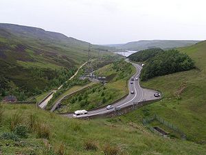
but it was never built. From here the A628
A628 road
The A628 is a major road in the north of England connecting Greater Manchester and South Yorkshire by crossing the Pennine chain of hills by way of the Woodhead Pass through the Peak District National Park. The height and the exposure of the road often creates problems during poor weather in winter...
runs through the valley to join the A616
A616 road
The A616 is a road which links Newark-on-Trent, Nottinghamshire, to the M1 motorway at Junction 30, then reappears at Junction 35A and goes on to Huddersfield, West Yorkshire....
.
As of January 2008 there are advanced plans to improve the A628 route by bypassing Mottram
Mottram
Mottram may refer to:* People:** Craig Mottram, an Australian distance runner** Don Mottram, an English flavour chemist** Ralph Hale Mottram, an English writer** Richard Mottram, a senior UK civil servant** Eric Mottram, an English poet...
and Tintwistle
Tintwistle
Tintwistle is a village and civil parish in the High Peak district of the non-metropolitan county of Derbyshire, England. According to the 2001 census the parish had a population of 1,401. The village is just north of Glossop at the lower end of Longdendale Valley...
to the north with a spur to the A57 road
A57 road
The A57 is a major road in England. It runs east from Liverpool to Lincoln, via Warrington, Cadishead, Irlam, Patricroft, Eccles, Salford and Manchester, then through the Pennines over the Snake Pass , around the Ladybower Reservoir, through Sheffield and past Worksop...
. Known as the 'A57/A628 Mottram-in-Longdendale, Hollingworth & Tintwistle Bypass' or Longdendale Bypass
Longdendale Bypass
The Longdendale Bypass was a controversial road scheme in England by the Highways Agency. The aim was to alleviate traffic congestion on the A57 road/A628 road/A616 road routes that presently pass through the villages...
, the public inquiry has been adjourned four times and is currently adjourned 'indefinitely'.
Rail
The Woodhead LineWoodhead Line
The Woodhead Line was a railway line linking Sheffield, Penistone and Manchester in the north of England. A key feature of the route is the passage under the high moorlands of the northern Peak District through the Woodhead Tunnels...
used to run though the valley using the Woodhead Tunnel
Woodhead Tunnel
The Woodhead Tunnels are three parallel trans-Pennine 3-mile long railway tunnels on the Woodhead Line, a former major rail link from Manchester to Sheffield in northern England...
. The national grid intend to install cable runs in the newest tunnel although others wish to re-open the line for freight.
Politics
Traditionally, Longdendale was in the County palatine of Chester. Up until local government reformsLocal Government Act 1972
The Local Government Act 1972 is an Act of Parliament in the United Kingdom that reformed local government in England and Wales on 1 April 1974....
in 1974, Longdendale Urban District, along with Tintwistle Rural District
Tintwistle
Tintwistle is a village and civil parish in the High Peak district of the non-metropolitan county of Derbyshire, England. According to the 2001 census the parish had a population of 1,401. The village is just north of Glossop at the lower end of Longdendale Valley...
, formed part of the administrative county of Cheshire; the Municipal Borough of Glossop
Glossop
Glossop is a market town within the Borough of High Peak in Derbyshire, England. It lies on the Glossop Brook, a tributary of the River Etherow, about east of the city of Manchester, west of the city of Sheffield. Glossop is situated near Derbyshire's county borders with Cheshire, Greater...
was in Derbyshire; and Penistone Rural District
Penistone Rural District
Penistone Rural District was a rural district in the West Riding of Yorkshire. It was named after but did not contain Penistone. The town itself was contained within the Penistone Urban District....
was in the West Riding of Yorkshire
West Riding of Yorkshire
The West Riding of Yorkshire is one of the three historic subdivisions of Yorkshire, England. From 1889 to 1974 the administrative county, County of York, West Riding , was based closely on the historic boundaries...
. Today, the valley is split between the Metropolitan Borough of Barnsley
Metropolitan Borough of Barnsley
The Metropolitan Borough of Barnsley is a metropolitan borough of the metropolitan county of South Yorkshire, England. Its main town is Barnsley....
in South Yorkshire, the Borough of High Peak in Derbyshire, and the Metropolitan Borough of Tameside
Tameside
The Metropolitan Borough of Tameside is a metropolitan borough of Greater Manchester in North West England. It is named after the River Tame which flows through the borough and spans the towns of Ashton-under-Lyne, Audenshaw, Denton, Droylsden, Dukinfield, Hyde, Mossley and Stalybridge. Its western...
in Greater Manchester.
The ward of Longdendale has three out of the fifty seven seats on Tameside Metropolitan Borough Council, and as of the 2007 local elections all three seats were held by the Labour Party
Labour Party (UK)
The Labour Party is a centre-left democratic socialist party in the United Kingdom. It surpassed the Liberal Party in general elections during the early 1920s, forming minority governments under Ramsay MacDonald in 1924 and 1929-1931. The party was in a wartime coalition from 1940 to 1945, after...
. The Councillors representing Longdendale on Tameside Council are:
- Janet Cooper - elected 2010 / end of term 2014
- Gill Peet - elected 2011 / end of term 2015
- Sean Parker-Perry - elected 2003 / end of term 2012
The ward is part of the Stalybrdige and Hyde constituency. In May 2010 Jonathan Reynolds
Jonathan Reynolds
Jonathan Neil Reynolds is a British Labour Co-operative politician, who has been the Member of Parliament for Stalybridge and Hyde since 2010....
became the MP for the constituency.
Longdendale lights
The valley and the surrounding area has a reputation for strange phenomena, including unexplained lights and allegedly supernaturalSupernatural
The supernatural or is that which is not subject to the laws of nature, or more figuratively, that which is said to exist above and beyond nature...
apparitions and has become a centre of attention for UFO and ghost hunters. It has, however, been suggested that the lights may be "earth lights" produced by pressure on the underlying rocks.