

Bleaklow
Encyclopedia
Bleaklow is a high, largely peat covered, gritstone
moorland
, just north of Kinder Scout
, across the Snake Pass
(A57
), in the Derbyshire
High Peak near the town of Glossop
. Much of it is nearly 2,000 feet (610 m) above sea level and it is the source of the River Derwent
.
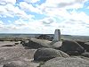
Bleaklow Head, the high point at the western side of the moor, is a Hewitt and is crossed by the Pennine Way
. It is one of three summits on this plateau above 2,000 feet, the others being Bleaklow Stones, some 1.9 miles (3 km) to the east along an indefinite ridge, and Higher Shelf Stones, 0.9 miles (1.5 km) south of Bleaklow Head. Bleaklow includes the most easterly point in the British Isles
over 2,000 feet, near Bleaklow Stones.
Much of the main plateau of Bleaklow is a boggy peat moorland, seamed by 'groughs' , and lacking strong changes in elevation – in poor conditions its traverse is probably the most navigationally challenging in the Peak District
.
Bleaklow is part of the National Trust's
High Peak Estate
.
In exceptional weather conditions it is possible to see Snowdonia
.
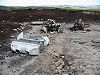
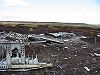
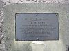
RB-29A Superfortress
44-61999 of the 16th Photographic Reconnaissance Squadron, 91st Reconnaissance Group, 311th Air Division, Strategic Air Command
, USAF
crashed at Higher Shelf Stones whilst on route from Scampton
to Burtonwood
. A large amount of wreckage is still visible.
Gritstone
Gritstone or Grit is a hard, coarse-grained, siliceous sandstone. This term is especially applied to such sandstones that are quarried for building material. British gritstone was used for millstones to mill flour, to grind wood into pulp for paper and for grindstones to sharpen blades. "Grit" is...
moorland
Moorland
Moorland or moor is a type of habitat, in the temperate grasslands, savannas, and shrublands biome, found in upland areas, characterised by low-growing vegetation on acidic soils and heavy fog...
, just north of Kinder Scout
Kinder Scout
Kinder Scout is a moorland plateau in the Dark Peak of the Derbyshire Peak District in England. Part of the moor, at 636 m above sea level, is the highest point in the Peak District, the highest point in Derbyshire, and the highest point in the East Midlands. It is accessible from the villages of...
, across the Snake Pass
Snake Pass
The Snake Pass is the name given to the remote, higher reaches of the A57 road where it crosses the Peak District between Manchester and Sheffield in the north of England...
(A57
A57 road
The A57 is a major road in England. It runs east from Liverpool to Lincoln, via Warrington, Cadishead, Irlam, Patricroft, Eccles, Salford and Manchester, then through the Pennines over the Snake Pass , around the Ladybower Reservoir, through Sheffield and past Worksop...
), in the Derbyshire
Derbyshire
Derbyshire is a county in the East Midlands of England. A substantial portion of the Peak District National Park lies within Derbyshire. The northern part of Derbyshire overlaps with the Pennines, a famous chain of hills and mountains. The county contains within its boundary of approx...
High Peak near the town of Glossop
Glossop
Glossop is a market town within the Borough of High Peak in Derbyshire, England. It lies on the Glossop Brook, a tributary of the River Etherow, about east of the city of Manchester, west of the city of Sheffield. Glossop is situated near Derbyshire's county borders with Cheshire, Greater...
. Much of it is nearly 2,000 feet (610 m) above sea level and it is the source of the River Derwent
River Derwent, Derbyshire
The Derwent is a river in the county of Derbyshire, England. It is 66 miles long and is a tributary of the River Trent which it joins south of Derby. For half its course, the river flows through the Peak District....
.
Bleaklow Head, the high point at the western side of the moor, is a Hewitt and is crossed by the Pennine Way
Pennine Way
The Pennine Way is a National Trail in England. The trail runs from Edale, in the northern Derbyshire Peak District, north through the Yorkshire Dales and the Northumberland National Park and ends at Kirk Yetholm, just inside the Scottish border. The path runs along the Pennine hills, sometimes...
. It is one of three summits on this plateau above 2,000 feet, the others being Bleaklow Stones, some 1.9 miles (3 km) to the east along an indefinite ridge, and Higher Shelf Stones, 0.9 miles (1.5 km) south of Bleaklow Head. Bleaklow includes the most easterly point in the British Isles
British Isles
The British Isles are a group of islands off the northwest coast of continental Europe that include the islands of Great Britain and Ireland and over six thousand smaller isles. There are two sovereign states located on the islands: the United Kingdom of Great Britain and Northern Ireland and...
over 2,000 feet, near Bleaklow Stones.
Much of the main plateau of Bleaklow is a boggy peat moorland, seamed by 'groughs' , and lacking strong changes in elevation – in poor conditions its traverse is probably the most navigationally challenging in the Peak District
Peak District
The Peak District is an upland area in central and northern England, lying mainly in northern Derbyshire, but also covering parts of Cheshire, Greater Manchester, Staffordshire, and South and West Yorkshire....
.
Bleaklow is part of the National Trust's
National Trust for Places of Historic Interest or Natural Beauty
The National Trust for Places of Historic Interest or Natural Beauty, usually known as the National Trust, is a conservation organisation in England, Wales and Northern Ireland...
High Peak Estate
High Peak Estate
The High Peak Estate is an area of Pennine moorland in the ownership of the National Trust in the Dark Peak area of Derbyshire, England.The National Trust High Peak Estate is to be known as the 'Dark Peak Area' from summer 2010 which is now part of the Peak District Estate...
.
In exceptional weather conditions it is possible to see Snowdonia
Snowdonia
Snowdonia is a region in north Wales and a national park of in area. It was the first to be designated of the three National Parks in Wales, in 1951.-Name and extent:...
.
Picture gallery
On 3 November 1948, BoeingBoeing
The Boeing Company is an American multinational aerospace and defense corporation, founded in 1916 by William E. Boeing in Seattle, Washington. Boeing has expanded over the years, merging with McDonnell Douglas in 1997. Boeing Corporate headquarters has been in Chicago, Illinois since 2001...
RB-29A Superfortress
B-29 Superfortress
The B-29 Superfortress is a four-engine propeller-driven heavy bomber designed by Boeing that was flown primarily by the United States Air Forces in late-World War II and through the Korean War. The B-29 was one of the largest aircraft to see service during World War II...
44-61999 of the 16th Photographic Reconnaissance Squadron, 91st Reconnaissance Group, 311th Air Division, Strategic Air Command
Strategic Air Command
The Strategic Air Command was both a Major Command of the United States Air Force and a "specified command" of the United States Department of Defense. SAC was the operational establishment in charge of America's land-based strategic bomber aircraft and land-based intercontinental ballistic...
, USAF
United States Air Force
The United States Air Force is the aerial warfare service branch of the United States Armed Forces and one of the American uniformed services. Initially part of the United States Army, the USAF was formed as a separate branch of the military on September 18, 1947 under the National Security Act of...
crashed at Higher Shelf Stones whilst on route from Scampton
RAF Scampton
Royal Air Force Station Scampton is a Royal Air Force station situated north of Lincoln in England, near the village of Scampton, on the site of an old First World War landing field.-First World War:...
to Burtonwood
RAF Burtonwood
RAF Burtonwood was a Royal Air Force station in England, 2 miles north-west of Warrington, Lancashire. During World War II and the Cold War it was used by the United States Air Force and was also known as USAAF station 590.- Overview :...
. A large amount of wreckage is still visible.
 |
 |
 |
 |
External links
- Computer generated summit panorama Bleaklow index
- There is a Dark Peak fieldwork website which includes a virtual tour of the Dark Peak area of the Peak District, and includes Bleaklow Dark Peak Co-authors are Cassandra Worman and Julia McMorrow (School of Geography, Manchester University). [link broken]
- PeakDistrictAirCrashes.co.uk. Resources about the B-29 wreck and other air accidents in this region.