
Bottoms Reservoir, Derbyshire
Encyclopedia
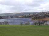
Bottoms Reservoir is a man-made lake
in Longdendale
in north Derbyshire
, England
. It was constructed between 1865 and 1877, by John Frederick Bateman
as part of the Longdendale chain
to supply water from the River Etherow
to the urban areas of Greater Manchester
. The upper reservoirs supplied the drinking water, while Bottoms and Vale House
reservoirs regulated the flow downstream for the benefit of local water-powered mills.
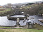 The reservoir was obliged to release 10m gallons a day; to ensure this, a gauging basin 40 feet in diameter,was built. The drinking water flowed by gravity through the Mottram Tunnel
to the Godley covered reservoir; Valehouse and Bottoms cannot contribute because they are too low.
In 1877 turbines were introduced at Bottoms to produce electricity that powered the company offices and the works electric train. These operated for 28 years.
In 1998 remedial safety work was done. The clay core and crest was raised by 2.5m, and a dry metalled track constructed on the crest. The bywash channel bridge was replaced to give greater clearance, and the stonework of the bywash channel and the tumbling bay was repointed.
Lake
A lake is a body of relatively still fresh or salt water of considerable size, localized in a basin, that is surrounded by land. Lakes are inland and not part of the ocean and therefore are distinct from lagoons, and are larger and deeper than ponds. Lakes can be contrasted with rivers or streams,...
in Longdendale
Longdendale
Longdendale is a valley in the north of England, north of Glossop and south east of Holmfirth. The name means "long wooded valley".- Geography :...
in north Derbyshire
Derbyshire
Derbyshire is a county in the East Midlands of England. A substantial portion of the Peak District National Park lies within Derbyshire. The northern part of Derbyshire overlaps with the Pennines, a famous chain of hills and mountains. The county contains within its boundary of approx...
, England
England
England is a country that is part of the United Kingdom. It shares land borders with Scotland to the north and Wales to the west; the Irish Sea is to the north west, the Celtic Sea to the south west, with the North Sea to the east and the English Channel to the south separating it from continental...
. It was constructed between 1865 and 1877, by John Frederick Bateman
John Frederick Bateman
John Frederick Bateman was an English civil engineer whose work formed the basis of the modern United Kingdom water supply industry. For over 50 years from 1835 he designed and constructed reservoirs and waterworks. His largest project was the system that supplied Manchester with much of its...
as part of the Longdendale chain
Longdendale Chain
The Longdendale Chain is a sequence of six reservoirs on the River Etherow in the valley of Longdendale, in northern Derbyshire. They were constructed between 1848 and 1884 to a design by John Frederick Bateman to supply the growing population of Manchester and Salford with fresh water.The top...
to supply water from the River Etherow
River Etherow
The River Etherow is a river in northern England, and a tributary of the River Goyt. Although now passing through South Yorkshire, Derbyshire and Greater Manchester, it historically formed the ancient county boundary between Cheshire and Derbyshire. The upper valley is known as Longdendale...
to the urban areas of Greater Manchester
Greater Manchester
Greater Manchester is a metropolitan county in North West England, with a population of 2.6 million. It encompasses one of the largest metropolitan areas in the United Kingdom and comprises ten metropolitan boroughs: Bolton, Bury, Oldham, Rochdale, Stockport, Tameside, Trafford, Wigan, and the...
. The upper reservoirs supplied the drinking water, while Bottoms and Vale House
Valehouse Reservoir
Valehouse Reservoir is a man-made lake in Longdendale in north Derbyshire. It was built between 1865 and 1869 as part of the Longdendale chain, which was built to supply water from the River Etherow to the urban areas of Greater Manchester while maintaining a constant flow into the river...
reservoirs regulated the flow downstream for the benefit of local water-powered mills.
Longdendale Chain
The Longdendale Chain is a sequence of six reservoirs on the River Etherow in the valley of Longdendale, in northern Derbyshire. They were constructed between 1848 and 1884 to a design by John Frederick Bateman to supply the growing population of Manchester and Salford with fresh water.The top...
to the Godley covered reservoir; Valehouse and Bottoms cannot contribute because they are too low.
In 1877 turbines were introduced at Bottoms to produce electricity that powered the company offices and the works electric train. These operated for 28 years.
In 1998 remedial safety work was done. The clay core and crest was raised by 2.5m, and a dry metalled track constructed on the crest. The bywash channel bridge was replaced to give greater clearance, and the stonework of the bywash channel and the tumbling bay was repointed.