
London-Brabant Island
Encyclopedia
The London-Brabant Massif or London-Brabant Platform is in the tectonic
structure of Europe a structural high
or massif
that stretches from the Rhineland
in western Germany
across northern Belgium
(in the province of Brabant
) and the North Sea
to the sites of East Anglia
and the middle Thames
in southern England
.
The massif also occurs in the Dutch subsurface, where it is bounded to the northeast by the Roer Valley Graben
that runs diagonally through Dutch Limburg
.
The Midlands Craton (southeastern Wales
and part of western England) is often considered part of the massif and to reflect this the names Wales-Brabant Massif, Wales-London-Brabant Massif and Wales-Brabant High are sometimes used.
The London-Brabant Massif is part of the former microcontinent Avalonia
. To the south it borders the Rhenohercynian Zone
of the Hercynian orogeny. To the northeast it is flanked by the Anglo-Dutch Basin in the subsurface of the North Sea.
At some moments in geologic history the London-Brabant Massif formed an island, which is called the London-Brabant Island.
(metamorphic
and igneous rock
s) with Proterozoic
to early Paleozoic
ages. It was deformed and metamorphosed
during the Cadomian orogeny
(Ediacaran
, about ago) and Caledonian orogeny
(Silurian
, about ). This basement is almost everywhere overlain by younger sedimentary rock
s, except for some places in the southwest of England and in Wales.
The continent Avalonia
was until the Ordovician
part of the large southern continent Gondwana
, but then began drifting
independently to lower latitude
s. As it passed through the dry latitudes represented today by the Namib Desert
1, it was eroded
and the soil
s became laterite
represented by the Old Red Sandstone
which shows its presence in the red soils of Devon
shire. The strata
, particularly of the Precambrian
are complex. Their continuity is also poorly understood because they are beyond the reach of most borehole
s.
. As the continent was drifting past the Equator
, on the island's shores, there grew a rich tropical forest swamp
. On the island's southern shore, it left the Dinantian
, Namurian
and Westphalian coal fields of France
, Belgium
and western Germany
. See Aachener Revier (in German).
To its northwest, the thinner crust between it and the Market Weighton Axis
was crumpled between the blocks leaving low ridges of wet land between strips of water such as the Widmerpool Gulf
. On the wet land, the coal fields of Leicestershire
, Nottinghamshire
and Derbyshire
were deposited. These extend further east but are now at ever greater depth. At the modern east Yorkshire
and north Lincolnshire
coast for example, their upper surface is at about 2 km depth. These Carboniferous beds are part of a system linking with those of Westphalia, around the north side of the island. On the north Norfolk
coast, the line of the Carboniferous shore roughly coincides with the modern one.2
and the red soils of Leicestershire and Rutland
.
The early Permian was the time of the height of the Variscan
earth movements as the crust to the south was crushed against the island. The great disturbances seen at the surface in Brittany
, the Ardennes
and the Rhineland
also lie below the Paris Basin. They fade out in the gentler anticline
of the downs and Weald of southern England which overlies the edge of the island. The axis of this anticline is normally called the northern Variscan front. However, the chalk of the downs is Upper Cretaceous, so the process continued well after the Permian. The point in the present context is that the stability of the island contrasts with the relatively unstable crust to its south, which was forced into a long mountain ridge.
To the north, economically important things were happening. Western Britain was pushed up as part of the Variscan Orogeny while the east of Britain, including the island began to subside leaving a broad basin, north of the island and south of Scandinavia. This formed a shallow sea in a very dry climate. Desert sands and salt basins were a result but there are also mudstones. This provided the alternating porous and imperveous rocks which have trapped the gas escaping when the coal measures, below were subjected to geothermal heat. This has left a group of gas fields off the Norfolk coast. That is to say, off the coast of the island.
, the Rhaetic sea flooded much of the Permian
plain. On the margin of the London-Brabant Island, the estuarine
conditions which left the Lower Estuarine Series
prevailed for a while before the sea rose so as to deposit the Lincolnshire limestone
s before falling again so that the Upper Estuarine Series was left. Again the sea rose to deposit the Blisworth Limestone
, the Blisworth Clay and the Upper Jurassic clays.
The same general pattern occurred in France leaving the Paris Basin
flooded from Anjou to Luxembourg.
 By the Cretaceous
the island had sunk much further in relation to the sea level. Before the end of the period, the British end was buried in Upper Cretaceous chalk. This happened because the Pacific Ocean bed swelled up causing the world’s seas to rise but also, the process released much carbon dioxide.
, commonly Moho) to depths greater than 40 kilometres as against a figure at the top of the continental shelf
of about thirty and less than fifteen below oceanic depths
.3
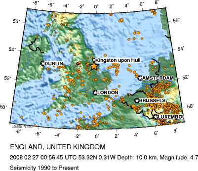
The map shows that there is some tendency for such seismic activity as there is in the region, to occur around the margin of the massif. It was into this pattern that the Dover Straits earthquake of 1580
and the 2008 Lincolnshire earthquake
, the latter marked by an orange star, fell.
Tectonics
Tectonics is a field of study within geology concerned generally with the structures within the lithosphere of the Earth and particularly with the forces and movements that have operated in a region to create these structures.Tectonics is concerned with the orogenies and tectonic development of...
structure of Europe a structural high
High (tectonics)
A high is in structural geology and tectonics an area where tectonic uplift has taken place relative to its surroundings. Highs are often bounded by normal faults and can be regarded as the opposites of basins. A related word is a massif, an area where relative old rocks layers are found at the...
or massif
Massif
In geology, a massif is a section of a planet's crust that is demarcated by faults or flexures. In the movement of the crust, a massif tends to retain its internal structure while being displaced as a whole...
that stretches from the Rhineland
Rhineland
Historically, the Rhinelands refers to a loosely-defined region embracing the land on either bank of the River Rhine in central Europe....
in western Germany
Germany
Germany , officially the Federal Republic of Germany , is a federal parliamentary republic in Europe. The country consists of 16 states while the capital and largest city is Berlin. Germany covers an area of 357,021 km2 and has a largely temperate seasonal climate...
across northern Belgium
Belgium
Belgium , officially the Kingdom of Belgium, is a federal state in Western Europe. It is a founding member of the European Union and hosts the EU's headquarters, and those of several other major international organisations such as NATO.Belgium is also a member of, or affiliated to, many...
(in the province of Brabant
Province of Brabant
Brabant was a province of the United Kingdom of the Netherlands from 1815 until 1830 and a province of Belgium from 1830 until 1995, when it was split into the Dutch-speaking Flemish Brabant, the French-speaking Walloon Brabant and the bilingual Brussels-Capital Region.-United Kingdom of the...
) and the North Sea
North Sea
In the southwest, beyond the Straits of Dover, the North Sea becomes the English Channel connecting to the Atlantic Ocean. In the east, it connects to the Baltic Sea via the Skagerrak and Kattegat, narrow straits that separate Denmark from Norway and Sweden respectively...
to the sites of East Anglia
East Anglia
East Anglia is a traditional name for a region of eastern England, named after an ancient Anglo-Saxon kingdom, the Kingdom of the East Angles. The Angles took their name from their homeland Angeln, in northern Germany. East Anglia initially consisted of Norfolk and Suffolk, but upon the marriage of...
and the middle Thames
River Thames
The River Thames flows through southern England. It is the longest river entirely in England and the second longest in the United Kingdom. While it is best known because its lower reaches flow through central London, the river flows alongside several other towns and cities, including Oxford,...
in southern England
England
England is a country that is part of the United Kingdom. It shares land borders with Scotland to the north and Wales to the west; the Irish Sea is to the north west, the Celtic Sea to the south west, with the North Sea to the east and the English Channel to the south separating it from continental...
.
The massif also occurs in the Dutch subsurface, where it is bounded to the northeast by the Roer Valley Graben
Graben
In geology, a graben is a depressed block of land bordered by parallel faults. Graben is German for ditch. Graben is used for both the singular and plural....
that runs diagonally through Dutch Limburg
Limburg (Belgium)
Limburg is the easternmost province of modern Flanders, which is one of the three main political and cultural sub-divisions of modern Belgium. It is located west of the river Meuse . It borders on the Dutch provinces of North Brabant and Limburg and the Belgian provinces of Liège, Flemish Brabant...
.
The Midlands Craton (southeastern Wales
Wales
Wales is a country that is part of the United Kingdom and the island of Great Britain, bordered by England to its east and the Atlantic Ocean and Irish Sea to its west. It has a population of three million, and a total area of 20,779 km²...
and part of western England) is often considered part of the massif and to reflect this the names Wales-Brabant Massif, Wales-London-Brabant Massif and Wales-Brabant High are sometimes used.
The London-Brabant Massif is part of the former microcontinent Avalonia
Avalonia
Avalonia was a microcontinent in the Paleozoic era. Crustal fragments of this former microcontinent underlie south-west Great Britain, and the eastern coast of North America. It is the source of many of the older rocks of Western Europe, Atlantic Canada, and parts of the coastal United States...
. To the south it borders the Rhenohercynian Zone
Rhenohercynian Zone
The Rhenohercynian Zone is in structural geology a fold belt of west and central Europe, formed during the Hercynian orogeny . The zone consists of folded and thrusted Devonian and early Carboniferous sedimentary rocks that were deposited in a back-arc basin along the southern margin of the then...
of the Hercynian orogeny. To the northeast it is flanked by the Anglo-Dutch Basin in the subsurface of the North Sea.
At some moments in geologic history the London-Brabant Massif formed an island, which is called the London-Brabant Island.
Formation
The massif is composed of crystalline basementBasement (geology)
In geology, the terms basement and crystalline basement are used to define the rocks below a sedimentary platform or cover, or more generally any rock below sedimentary rocks or sedimentary basins that are metamorphic or igneous in origin...
(metamorphic
Metamorphic rock
Metamorphic rock is the transformation of an existing rock type, the protolith, in a process called metamorphism, which means "change in form". The protolith is subjected to heat and pressure causing profound physical and/or chemical change...
and igneous rock
Igneous rock
Igneous rock is one of the three main rock types, the others being sedimentary and metamorphic rock. Igneous rock is formed through the cooling and solidification of magma or lava...
s) with Proterozoic
Proterozoic
The Proterozoic is a geological eon representing a period before the first abundant complex life on Earth. The name Proterozoic comes from the Greek "earlier life"...
to early Paleozoic
Paleozoic
The Paleozoic era is the earliest of three geologic eras of the Phanerozoic eon, spanning from roughly...
ages. It was deformed and metamorphosed
Metamorphism
Metamorphism is the solid-state recrystallization of pre-existing rocks due to changes in physical and chemical conditions, primarily heat, pressure, and the introduction of chemically active fluids. Mineralogical, chemical and crystallographic changes can occur during this process...
during the Cadomian orogeny
Cadomian Orogeny
The Cadomian Orogeny was a tectonic event or series of events in the late Neoproterozoic, about 650-550 Ma, which probably included the formation of mountains. This occurred on the margin of the Gondwana continent, involving one or more collisions of island arcs and accretion of other material at a...
(Ediacaran
Ediacaran
The Ediacaran Period , named after the Ediacara Hills of South Australia, is the last geological period of the Neoproterozoic Era and of the Proterozoic Eon, immediately preceding the Cambrian Period, the first period of the Paleozoic Era and of the Phanerozoic Eon...
, about ago) and Caledonian orogeny
Caledonian orogeny
The Caledonian orogeny is a mountain building era recorded in the northern parts of the British Isles, the Scandinavian Mountains, Svalbard, eastern Greenland and parts of north-central Europe. The Caledonian orogeny encompasses events that occurred from the Ordovician to Early Devonian, roughly...
(Silurian
Silurian
The Silurian is a geologic period and system that extends from the end of the Ordovician Period, about 443.7 ± 1.5 Mya , to the beginning of the Devonian Period, about 416.0 ± 2.8 Mya . As with other geologic periods, the rock beds that define the period's start and end are well identified, but the...
, about ). This basement is almost everywhere overlain by younger sedimentary rock
Sedimentary rock
Sedimentary rock are types of rock that are formed by the deposition of material at the Earth's surface and within bodies of water. Sedimentation is the collective name for processes that cause mineral and/or organic particles to settle and accumulate or minerals to precipitate from a solution....
s, except for some places in the southwest of England and in Wales.
The continent Avalonia
Avalonia
Avalonia was a microcontinent in the Paleozoic era. Crustal fragments of this former microcontinent underlie south-west Great Britain, and the eastern coast of North America. It is the source of many of the older rocks of Western Europe, Atlantic Canada, and parts of the coastal United States...
was until the Ordovician
Ordovician
The Ordovician is a geologic period and system, the second of six of the Paleozoic Era, and covers the time between 488.3±1.7 to 443.7±1.5 million years ago . It follows the Cambrian Period and is followed by the Silurian Period...
part of the large southern continent Gondwana
Gondwana
In paleogeography, Gondwana , originally Gondwanaland, was the southernmost of two supercontinents that later became parts of the Pangaea supercontinent. It existed from approximately 510 to 180 million years ago . Gondwana is believed to have sutured between ca. 570 and 510 Mya,...
, but then began drifting
Continental drift
Continental drift is the movement of the Earth's continents relative to each other. The hypothesis that continents 'drift' was first put forward by Abraham Ortelius in 1596 and was fully developed by Alfred Wegener in 1912...
independently to lower latitude
Latitude
In geography, the latitude of a location on the Earth is the angular distance of that location south or north of the Equator. The latitude is an angle, and is usually measured in degrees . The equator has a latitude of 0°, the North pole has a latitude of 90° north , and the South pole has a...
s. As it passed through the dry latitudes represented today by the Namib Desert
Namib Desert
The Namib Desert is a desert in Namibia and southwest Angola that forms part of the Namib-Naukluft National Park, the largest game reserve in Africa. The name "Namib" is of Nama origin and means "vast place"...
1, it was eroded
Erosion
Erosion is when materials are removed from the surface and changed into something else. It only works by hydraulic actions and transport of solids in the natural environment, and leads to the deposition of these materials elsewhere...
and the soil
Soil
Soil is a natural body consisting of layers of mineral constituents of variable thicknesses, which differ from the parent materials in their morphological, physical, chemical, and mineralogical characteristics...
s became laterite
Laterite
Laterites are soil types rich in iron and aluminium, formed in hot and wet tropical areas. Nearly all laterites are rusty-red because of iron oxides. They develop by intensive and long-lasting weathering of the underlying parent rock...
represented by the Old Red Sandstone
Old Red Sandstone
The Old Red Sandstone is a British rock formation of considerable importance to early paleontology. For convenience the short version of the term, 'ORS' is often used in literature on the subject.-Sedimentology:...
which shows its presence in the red soils of Devon
Devon
Devon is a large county in southwestern England. The county is sometimes referred to as Devonshire, although the term is rarely used inside the county itself as the county has never been officially "shired", it often indicates a traditional or historical context.The county shares borders with...
shire. The strata
Stratum
In geology and related fields, a stratum is a layer of sedimentary rock or soil with internally consistent characteristics that distinguish it from other layers...
, particularly of the Precambrian
Precambrian
The Precambrian is the name which describes the large span of time in Earth's history before the current Phanerozoic Eon, and is a Supereon divided into several eons of the geologic time scale...
are complex. Their continuity is also poorly understood because they are beyond the reach of most borehole
Borehole
A borehole is the generalized term for any narrow shaft bored in the ground, either vertically or horizontally. A borehole may be constructed for many different purposes, including the extraction of water or other liquid or gases , as part of a geotechnical investigation, environmental site...
s.
The Carboniferous
The period from which the island has exercised most economic influence on modern Europe was the CarboniferousCarboniferous
The Carboniferous is a geologic period and system that extends from the end of the Devonian Period, about 359.2 ± 2.5 Mya , to the beginning of the Permian Period, about 299.0 ± 0.8 Mya . The name is derived from the Latin word for coal, carbo. Carboniferous means "coal-bearing"...
. As the continent was drifting past the Equator
Equator
An equator is the intersection of a sphere's surface with the plane perpendicular to the sphere's axis of rotation and containing the sphere's center of mass....
, on the island's shores, there grew a rich tropical forest swamp
Swamp
A swamp is a wetland with some flooding of large areas of land by shallow bodies of water. A swamp generally has a large number of hammocks, or dry-land protrusions, covered by aquatic vegetation, or vegetation that tolerates periodical inundation. The two main types of swamp are "true" or swamp...
. On the island's southern shore, it left the Dinantian
Dinantian
Dinantian is the name of a series or epoch from the Lower Carboniferous system in Europe. It can stand for a series of rocks in Europe or the time span in which they were deposited....
, Namurian
Namurian
The Namurian is a stage in the regional stratigraphy of northwest Europe with an age between roughly 326 and 313 Ma . It is a subdivision of the Carboniferous system or period and the regional Silesian series. The Namurian is named for the Belgian city and province of Namur where strata of this age...
and Westphalian coal fields of France
France
The French Republic , The French Republic , The French Republic , (commonly known as France , is a unitary semi-presidential republic in Western Europe with several overseas territories and islands located on other continents and in the Indian, Pacific, and Atlantic oceans. Metropolitan France...
, Belgium
Belgium
Belgium , officially the Kingdom of Belgium, is a federal state in Western Europe. It is a founding member of the European Union and hosts the EU's headquarters, and those of several other major international organisations such as NATO.Belgium is also a member of, or affiliated to, many...
and western Germany
Westphalia
Westphalia is a region in Germany, centred on the cities of Arnsberg, Bielefeld, Dortmund, Minden and Münster.Westphalia is roughly the region between the rivers Rhine and Weser, located north and south of the Ruhr River. No exact definition of borders can be given, because the name "Westphalia"...
. See Aachener Revier (in German).
To its northwest, the thinner crust between it and the Market Weighton Axis
Market Weighton Axis
The Market Weighton Axis is a geological feature which forms the south-eastern part of Yorkshire, England. The feature goes under a number of names such as 'block' or 'area' while the name of the town, Market Weighton is retained...
was crumpled between the blocks leaving low ridges of wet land between strips of water such as the Widmerpool Gulf
Widmerpool Gulf
The Widmerpool Gulf is a name given to a sedimentary basin that existed as an area of open water during the Early Carboniferous . It is named after Widmerpool, near Nottingham and was an extension eastwards as far as Lincolnshire, of the North Staffordshire Gulf...
. On the wet land, the coal fields of Leicestershire
Leicestershire
Leicestershire is a landlocked county in the English Midlands. It takes its name from the heavily populated City of Leicester, traditionally its administrative centre, although the City of Leicester unitary authority is today administered separately from the rest of Leicestershire...
, Nottinghamshire
Nottinghamshire
Nottinghamshire is a county in the East Midlands of England, bordering South Yorkshire to the north-west, Lincolnshire to the east, Leicestershire to the south, and Derbyshire to the west...
and Derbyshire
Derbyshire
Derbyshire is a county in the East Midlands of England. A substantial portion of the Peak District National Park lies within Derbyshire. The northern part of Derbyshire overlaps with the Pennines, a famous chain of hills and mountains. The county contains within its boundary of approx...
were deposited. These extend further east but are now at ever greater depth. At the modern east Yorkshire
Yorkshire
Yorkshire is a historic county of northern England and the largest in the United Kingdom. Because of its great size in comparison to other English counties, functions have been increasingly undertaken over time by its subdivisions, which have also been subject to periodic reform...
and north Lincolnshire
Lincolnshire
Lincolnshire is a county in the east of England. It borders Norfolk to the south east, Cambridgeshire to the south, Rutland to the south west, Leicestershire and Nottinghamshire to the west, South Yorkshire to the north west, and the East Riding of Yorkshire to the north. It also borders...
coast for example, their upper surface is at about 2 km depth. These Carboniferous beds are part of a system linking with those of Westphalia, around the north side of the island. On the north Norfolk
Norfolk
Norfolk is a low-lying county in the East of England. It has borders with Lincolnshire to the west, Cambridgeshire to the west and southwest and Suffolk to the south. Its northern and eastern boundaries are the North Sea coast and to the north-west the county is bordered by The Wash. The county...
coast, the line of the Carboniferous shore roughly coincides with the modern one.2
The Permian and Triassic
As the continent drifted northwards, away from the Equator, through the latitudes represented today by the Sahara desert, the erosion was renewed. This time, the lateritic soils are represented by the New Red SandstoneNew Red Sandstone
The New Red Sandstone is a chiefly British geological term for the beds of red sandstone and associated rocks laid down throughout the Permian to the beginning of the Triassic that underlie the Jurassic Lias; the term distinguishes it from the Old Red Sandstone which is largely Devonian in...
and the red soils of Leicestershire and Rutland
Rutland
Rutland is a landlocked county in central England, bounded on the west and north by Leicestershire, northeast by Lincolnshire and southeast by Peterborough and Northamptonshire....
.
The early Permian was the time of the height of the Variscan
Variscan orogeny
The Variscan orogeny is a geologic mountain-building event caused by Late Paleozoic continental collision between Euramerica and Gondwana to form the supercontinent of Pangaea.-Naming:...
earth movements as the crust to the south was crushed against the island. The great disturbances seen at the surface in Brittany
Brittany
Brittany is a cultural and administrative region in the north-west of France. Previously a kingdom and then a duchy, Brittany was united to the Kingdom of France in 1532 as a province. Brittany has also been referred to as Less, Lesser or Little Britain...
, the Ardennes
Ardennes
The Ardennes is a region of extensive forests, rolling hills and ridges formed within the Givetian Ardennes mountain range, primarily in Belgium and Luxembourg, but stretching into France , and geologically into the Eifel...
and the Rhineland
Rhineland
Historically, the Rhinelands refers to a loosely-defined region embracing the land on either bank of the River Rhine in central Europe....
also lie below the Paris Basin. They fade out in the gentler anticline
Anticline
In structural geology, an anticline is a fold that is convex up and has its oldest beds at its core. The term is not to be confused with antiform, which is a purely descriptive term for any fold that is convex up. Therefore if age relationships In structural geology, an anticline is a fold that is...
of the downs and Weald of southern England which overlies the edge of the island. The axis of this anticline is normally called the northern Variscan front. However, the chalk of the downs is Upper Cretaceous, so the process continued well after the Permian. The point in the present context is that the stability of the island contrasts with the relatively unstable crust to its south, which was forced into a long mountain ridge.
To the north, economically important things were happening. Western Britain was pushed up as part of the Variscan Orogeny while the east of Britain, including the island began to subside leaving a broad basin, north of the island and south of Scandinavia. This formed a shallow sea in a very dry climate. Desert sands and salt basins were a result but there are also mudstones. This provided the alternating porous and imperveous rocks which have trapped the gas escaping when the coal measures, below were subjected to geothermal heat. This has left a group of gas fields off the Norfolk coast. That is to say, off the coast of the island.
Rhaetic Transgression
In the early JurassicJurassic
The Jurassic is a geologic period and system that extends from about Mya to Mya, that is, from the end of the Triassic to the beginning of the Cretaceous. The Jurassic constitutes the middle period of the Mesozoic era, also known as the age of reptiles. The start of the period is marked by...
, the Rhaetic sea flooded much of the Permian
Permian
The PermianThe term "Permian" was introduced into geology in 1841 by Sir Sir R. I. Murchison, president of the Geological Society of London, who identified typical strata in extensive Russian explorations undertaken with Edouard de Verneuil; Murchison asserted in 1841 that he named his "Permian...
plain. On the margin of the London-Brabant Island, the estuarine
Estuary
An estuary is a partly enclosed coastal body of water with one or more rivers or streams flowing into it, and with a free connection to the open sea....
conditions which left the Lower Estuarine Series
Lower Estuarine Series
The Lower Estuarine Series, also called in more modern publications, the Grantham Formation, is a relatively complex but generally thin set of geological strata which are usually considered as a group. It forms a lower part of the Inferior Oolite Series, which lies in the Middle Jurassic...
prevailed for a while before the sea rose so as to deposit the Lincolnshire limestone
Lincolnshire limestone
The Lincolnshire limestone is a feature of the Inferior Oolite Series of the Middle Jurassic strata of eastern England. It was formed around 165 million years ago, in a shallow, warm sea on the margin of the London Platform and has estuarine beds above and below it...
s before falling again so that the Upper Estuarine Series was left. Again the sea rose to deposit the Blisworth Limestone
Blisworth Limestone
The Blisworth Limestone is a stratum of limestone of the Bathonian stage, found in the Jurassic ridge which extends north and south through England. It was laid down in the shallows of the Jurassic sea and is part of the more widely defined Great Oölite Series. It is also known as the Great Oolite...
, the Blisworth Clay and the Upper Jurassic clays.
The same general pattern occurred in France leaving the Paris Basin
Paris Basin (geology)
The Paris Basin is one of the major geological regions of France having developed since the Triassic on a basement formed by the Variscan orogeny.-Extent:...
flooded from Anjou to Luxembourg.
Cretaceous
Cretaceous
The Cretaceous , derived from the Latin "creta" , usually abbreviated K for its German translation Kreide , is a geologic period and system from circa to million years ago. In the geologic timescale, the Cretaceous follows the Jurassic period and is followed by the Paleogene period of the...
the island had sunk much further in relation to the sea level. Before the end of the period, the British end was buried in Upper Cretaceous chalk. This happened because the Pacific Ocean bed swelled up causing the world’s seas to rise but also, the process released much carbon dioxide.
Modern existence
It is now best viewed as a block of dense crust floating deeply sunk into the mantle and overlain with less dense superficial rocks. It depresses the boundary of the crust and the mantle (Mohorovičić discontinuityMohorovičić discontinuity
The Mohorovičić discontinuity , usually referred to as the Moho, is the boundary between the Earth's crust and the mantle. Named after the pioneering Croatian seismologist Andrija Mohorovičić, the Moho separates both the oceanic crust and continental crust from underlying mantle...
, commonly Moho) to depths greater than 40 kilometres as against a figure at the top of the continental shelf
Continental shelf
The continental shelf is the extended perimeter of each continent and associated coastal plain. Much of the shelf was exposed during glacial periods, but is now submerged under relatively shallow seas and gulfs, and was similarly submerged during other interglacial periods. The continental margin,...
of about thirty and less than fifteen below oceanic depths
Oceanic crust
Oceanic crust is the part of Earth's lithosphere that surfaces in the ocean basins. Oceanic crust is primarily composed of mafic rocks, or sima, which is rich in iron and magnesium...
.3
The map shows that there is some tendency for such seismic activity as there is in the region, to occur around the margin of the massif. It was into this pattern that the Dover Straits earthquake of 1580
Dover Straits earthquake of 1580
Though severe earthquakes in the north of France and Britain are rare, the Dover Straits earthquake of 6 April 1580 appears to have been one of the largest in the recorded history of England, Flanders or northern France...
and the 2008 Lincolnshire earthquake
2008 Lincolnshire earthquake
The 2008 Lincolnshire earthquake struck Lincolnshire, in the United Kingdom, on 27 February 2008 at 00:56:47.8s GMT. According to the British Geological Survey, the quake registered a reading of 5.2 on the Richter scale with the epicentre 2.5 miles north of Market Rasen and 15 miles ...
, the latter marked by an orange star, fell.
External links
Belgian Geological Service – Cartography – Subcrop map – Brabant MassifFootnote
- Note 1: Reference to modern climate regions is intended to be helpful in envisaging events but although the basic climate zonesClimeThe seven climes was a notion of dividing the Earth into zones in Classical Antiquity....
persisted throughout the story, the changing configuration of the continents had a great and changing effect on the configuration of the climate zones. - Note 2: Gallois, Figure 9 shows how the overlying strata lie in relation to it in north Norfolk.
- Note 3: Dercourt, Figure 6.2.