
Geography of Western Australia
Encyclopedia
Western Australia
occupies nearly one third of the Australian continent. Due to the size and the isolation of the state, considerable emphasis has been made of these features; it is the second largest administrative territory in the world, after Yakutia in Russia
, and no other regional administrative jurisdiction in the world occupies such a high percentage of a continental land mass.
Its capital city, Perth
, is also considered to be amongst the world's most isolated, being closer to Jakarta
in Indonesia, than to the Australian national capital in Canberra
.
, and the Yilgarn Craton
of the Great Western Plateau, which occupies most of the state, has been above sea level for over 2.5 billion years, giving it some of the oldest soils of the planet. Equally, culturally, Charles Doortch has identified Aboriginal stone tools, found at Rottnest, as dating possibly to 70,000 years, making them amongst the first evidence of modern homo sapiens found outside Africa.
The European settlement of Western Australia started in 1827, at Albany
, but the state was only established as an administrative colony in 1829, and much of the state was only subsequently developed, with the extent of the pastoral industries from the 1860s and with the mineral industries from the 1890s to the present day. Western Australia has the highest proportion of non-state born population of any of the Australian states, and this coupled with the fact that over 76% of the population live in Perth means that the proportion of the population who have a deep understanding of the geography of their state is limited.
The geography of Western Australia has been of interest ever since the 17th century when the state was first visited by Dutch East India Company
(VOC) explorers, traveling the shorter "roaring forties
" route from Cape Town
to Batavia
(Jakarta) in what was then the Dutch East Indies (now Indonesia). Lacking the ability to accurately measure longitude, it was easy to overestimate the distance required to be traveled with the consequence that arrival upon the western shores of Western Australia became a more frequent occurrence.
Dutch explorers too often suffered from collision with the many reefs along the western coast, a result of the warm Leeuwin current, that baths the western shores, and has a huge effect upon creating the favourable Mediterranean climate of the south west corner of the state. Abel Janzoon Tasman, for instance, was sent from Batavia to scout the size of the new continent discovered. By the mid 18th century, the whole of the Western shoreline of the state had been mapped to a reasonable degree of accuracy, although these maps were improved subsequently by the British explorers George Vancouver
, Phillip Parker King and Matthew Flinders
.
 Western Australia is divided in half climatically by a belt of descending dry high pressure system airflow, generally along the Tropic of Capricorn
between the north, in which a summer rainfall pattern predominates, and the south, characterised by winter rainfall.
The northern part of the state, characterised by Monsoon
al circulation, in the winter months from May to September is of generally warm dry offshore winds, drawn across the Inter-Tropical Convergence Zone by the low pressure systems of Monsoon Asia. In summer, from November to March, with the displacement of the Intertropical Convergence over northern Australia, the weather is characterised by humid tropical onshore airflows, coupled with thunderstorms and an occasional cyclone
, these weather patterns bringing the bulk of the rainfall of the region. The highest wind-gust recorded on the Australian mainland was 259 km/h at Mardi during tropical cyclone Trixie, in 1975 and Whim Creek has the record for the highest rainfall, at 747 mm in 24 hours, associated with a cyclone in 1898.
In the southern part of the state the bulk of rainfall comes from west to east moving cold frontal low pressure depressions, originating off the edge of the winter pack-ice
in the Southern Ocean
, south of South Africa. Cold southern airflows, wedging beneath humid north westerly winds triggers vertical instabilities, bringing this region the bulk of its rain between May and August. During the summer months these frontal depressions travel well to the south, leading to warm high pressure systems dominating the southern part of the state.
As a result the state is classified with five climates in the Köppen climate classification
s, ranging from Aw Tropical wet-dry climates in the Kimberley region of the state, through BSh Semiarid (summer rainfall) to the south of the Kimberley, BW Arid climates, covering the Great Sandy Desert
, Central Australian Desert, Gibson Desert
and the Great Victoria Desert
, BSh Semiarid (winter rainfall), from Shark Bay to the Nullabor, and then a Csa Mediterranean climate
from Northampton
to Esperance
and covering the Southwest of the state.
records only 219 mm of rain over an average of 43 days. Whilst Laverton receives the bulk of its rain from frontal systems hat occasionally extend through to the Goldfields, Giles is generally dry from July through to September and gets the bulk of its rain from tropical cyclones which collapse into tropical depressions, bringing sudden rain into the interior.
effect along the Darling Scarp, with the result that the rainfall pattern shows an area of higher rainfalls extending from Collie north to the Chittering Brook and Karnet.
Western Australia emits 33.1 tonnes of net carbon dioxide equivalents (CO2-e) per capita, making the state one of the highest contributors per capita in the world.
There are 25 biogeographic regions of 80 in the country, in the Interim Biogeographic Regions of Australia
(IBRA) system. The IBRA was developed in 1993-94 under the coordination of Environment Australia by the States and Territories as a basis for developing priorities for the Commonwealth in funding additions to the reserve system under the National Reserve System Cooperative Program, in order to ensure that a balance of representative biogeographic areas were preserved by National Parks and Nature Reserves.
The detailed IBRA analyses addressed:
In Western Australia this involved small changes in the Carnarvon Shark Bay area which was added to the Geraldton Sandplain region, Extension of the Yalgoo Region to include part of the Carnarvon region, transfer of the Salmongum woodland region from the Coolgardie to the Mallee biogeographic region and minor changes to the Central Ranges outliers.
The Avon Wheatbelt
This is an area of active drainage dissecting a Tertiary plateau in Yilgarn Craton. The gently undulating landscape of low relief has Proteaceous scrub-heaths, rich in endemics, on residual lateritic uplands and derived sandplains; mixed eucalypt, Allocasuarina huegeliana
and Jam-York Gum woodlands on Quaternary alluvials and eluvials. The south eastern boundary has been modified incorporating a small portion into the Mallee region. The whole region has been extensively cleared for agriculture, and rapid dry-land salinity is a major problem.
The Carnarvon Region
The Carnarvon region comprises Quaternary alluvial, aeolian and marine sediments overlying Cretaceous strata. There is a mosaic of saline alluvial plains with samphire and saltbush low shrublands, Bowgada low woodland on sandy ridges and plains, Snakewood
scrubs on clay flats, and tree to shrub steppe over hummock grasslands on and between red sand dune fields. The Limestone strata are covered with Acacia startii and binervia
shrublands outcrop in the north, where extensive tidal flats in sheltered embayments support Mangal vegetation.
The Coolgardie Region
Granite strata of Yilgarn Craton characterises Coolgardie, with Archaean Greenstone intrusions in parallel belts. Drainage is arheic and occluded. Mallees and scrubs are found on sandplains associated with lateritised uplands, playas and granite outcrops. Diverse woodlands rich are in K strategy endemic eucalypts, on low greenstone hills, valley alluvials and broad plains of calcareous earths. In the west of the region, the scrubs are rich in endemic Proteaceae
, in the east they are rich in endemic acacia
s.
The Central Ranges
There are a high proportion of Proterozoic ranges and derived soil plains, interspersed with red Quaternary sandplains in this region. The sandplains support low open woodlands of either Desert Oak or Mulga
over Triodia basedowii hummock grasslands. Low open woodlands of Ironwood (Acacia estrophiolata
) and Corkwoods (Hakea
spp.) are found over tussock and hummock grasses which often fringe the ranges. The ranges support mixed wattle scrub or Callitris glaucophylla woodlands again over hummock and tussock grasslands.
Dampierland
contains four distinct landforms.
The Esperance Plains
Proteaceous Scrub and mallee heaths are found on the sandplain overlying Eocene sediments. This area is particularly rich in endemic speciess. Herbfield
s and heaths (rich in endemics) are found on abrupt granite and quartzite ranges that rise from the plain. Eucalypt woodlands occur in gullies and alluvial foot-slopes.
The Gascoyne
In the Gascoyne region rugged low Proterozoic sedimentary and granite ranges are divided by broad flat valleys. Open mulga woodlands occur on shallow earthy loams over hardpan on the plains, with mulga scrub and Eremophila
shrublands on the shallow stony loams of the ranges. For the Carnegie Salient, in the east, it is characterised by extensive salt lake features supporting succulent steppes.
The Gibson Desert
The Gibson Desert is basically a lateritised upland on flat-lying Jurassic and Cretaceous sandstones of Canning Basin. Mulga parkland over Triodia basedowii is found on lateritic "buckshot" plains. Mixed shrub steppe of Acacia
, Hakea
and Grevillea
over Triodia pungens occurs on red sand plains and dune fields. Lateritic uplands support shrub steppe in the north and mulga scrub in the south. Quaternary alluvia that are associated with palaeo-drainage features support Coolabah
woodlands over bunch grasses.
The Geraldton Sandplain
The Geraldton Sandplain is a highly biodiverse region. Vegetation is mainly of proteaceous scrub-heaths, rich in endemics, on the sandy earths of an extensive, undulating, lateritic sandplain mantling Permian to Cretaceous strata. Extensive York Gum and Jam woodlands occur on outwash plains associated drainage.
The Great Sandy Desert
The Great Sandy Desert is mainly a tree steppe grading to shrub steppe in south. It comprises open hummock grassland of Triodia pungens and Plectrachne schinzii with scattered trees of Owenia reticulata and Bloodwood
s, and shrubs of Acacia
species, Grevillea wickhamii
and Grevillia refracta, on Quaternary red longitudinal sand dune fields overlying Jurassic and Cretaceous sandstones of the Canning, Centralian, Arunta and Armadeus Basins. Casuarina decaisneana (Desert Oak) occurs in the far east of the region. Gently undulating lateritised uplands support shrub steppe such as Acacia pachycarpa shrublands over Triodia pungens hummock grass. Calcrete and evaporite surfaces are associated with occluded palaeo-drainage systems that traverse the desert; these include extensive salt lake chains with samphire low shrublands, and Melaleuca glomerata - Melaleuca lasiandra shrublands.
The Great Victoria Desert
The Great Victoria Desert is an arid active sand-ridge desert of deep Quaternary aeolian sands overlying Permian and Mesozoic strata of the Officer Basin. Between sand-dune ridges there is a tree steppe of Eucalyptus gongylocarpa, Mulga and Eucalyptus youngiana
over hummock grassland dominated by Triodia basedowii.
The Hampton Region
The Hampton Region comprises Quaternary marine dune systems on a coastal plain of the Eucla Basin, backed by stranded limestone scarp. Areas of marine sand are also perched along the top edge of the scarp. Various mallee communities dominate the limestone scree slopes and pavements, as well as the sandy surfaces. Alluvial and calcareous plains are found below the scarp support eucalypt woodlands and Myall
open low woodlands.
The Jarrah Woodlands
The Duricrusted plateau of the western edge of the Yilgarn Craton is characterised by Jarrah
-Marri
forest on laterite gravels and, in the eastern part, by Marri-Wandoo woodlands on clayey soils. Eluvial and alluvial deposits support Agonis shrublands. In areas of Mesozoic sediments, Jarrah forests occur in a mosaic with a variety of species-rich shrublands. This area has been heavily logged for timber, Jarrah here being largely regrowth.
The Little Sandy Desert
In this region red Quaternary dune fields have abrupt Proterozoic sandstone ranges of Bangemall Basin. There is a shrub steppe of acacias, Thryptomene and grevilleas over Plectrachne schinzii on sandy surfaces. Sparse shrub-steppe is found over Triodia basedowii on stony hills, with River Gum communities and bunch grasslands on alluvial deposits in and associated with ranges.
The Mallee Region
This region has been re-defined to include an area from the Coolgardie Bioregion – the area between Lake Hope, Forrestiana and Mount Holland, which comprises Salmon Gum and Morrell
woodlands on greenstone, with smaller areas of mallee and Acacia / Casuarina thicket on sandplains. The south-eastern part of Yilgarn Craton is gently undulating, with partially occluded drainage. Vegetation is mainly mallee over myrtaceous-proteaceous heaths on duplex (sand over clay) soils. Melaleuca
shrublands characterise alluvia, and Halosarcia low shrublands occur on saline alluvium. A mosaic of mixed eucalypt woodlands and mallee occurs on calcareous earth plains and sandplains overlying Eocene limestone strata in the east.
The Murchison
This arid region of Mulga low woodlands, is often rich in ephemerals, on outcrop hardpan washplains and fine-textured Quaternary alluvial and eluvial surfaces mantling granitic and greenstone strata of the northern part of the Yilgarn Craton. Surfaces are associated with the occluded drainage occur throughout with hummock grasslands on Quaternary sandplains, saltbush shrublands on calcareous soils and Halosarcia low shrublands on saline alluvia. Areas of red sandplains are covered with mallee-mulga parkland over hummock grasslands occurring widely in the east.
The Northern Kimberley
This is tissected plateau of Kimberley Basin, covered with savanna woodland of Woolybutt and Darwin Stringybark over high Sorghum grasses and Plectrachne schinzii hummock grasses on shallow sandy soils on outcropping Proterozoic siliceous sandstone strata. Savanna woodlands on Eucalyptus tectifica - Eucalyptus grandiflora alliance over high Sorghum grasses on red and yellow earths mantling basic Proterozoic volcanics. Riparian closed forests of paperbark trees and Pandanus occur along drainage lines. Extensive Mangal
occurs in estuaries and sheltered embayments. Numerous small patches of monsoon rainforest are scattered through the district.
The Nullarbor
The Nullarbor is a Tertiary limestone plain with subdued arid karst features. Bluebush
- Saltbush steppe are found widely in central areas, a low open woodlands of Myall over bluebush is found in peripheral areas, including Myoporum platycarpum and Eucalyptus oleosa
in the east and west.
The Ord Victoria Plain
s
Here level to gently undulating plains with scattered hills are found on Cambrian volcanics and Proterozoic sedimentary rocks; vertosols on plains and predominantly skeletal soils on hills; grassland with scattered Bloodwood
and Snappy Gum with spinifex and annual grasses. The climate is of dry hot tropical, semi-arid summer rainfall. The lithological mosaic has three main components:
The Pilbara
There are four major components to the Pilbara Craton.
The Swan Coastal Plain
This is arguably the most damaged ecosystem in the state. This is a low lying coastal plain, mainly covered with Tuart-Banksia
woodlands. It is dominated by Banksia or Tuart on sandy soils, Allocasuarina obesa on outwash plains, and paperbark in numerous former swampy areas. In the east, the plain rises to duricrusted Mesozoic sediments dominated by Jarrah
woodland. Three phases of marine sand dune development provide relief. The outwash plains, once dominated by Allocasuarina obesa-marri
woodlands and Melaleuca
shrublands, are extensive only in the southern part of the region.
The Tanami
The Tanami region is of mainly red Quaternary sandplains overlying Permian and Proterozoic strata which are exposed locally as hills and ranges. The sandplains support mixed shrub steppes of Hakea suberea, desert bloodwoods, acacia
s and grevillea
s over Triodia pungens hummock grasslands. Wattle scrub over Triodia pungens hummock grass communities occur on the ranges. Alluvial and lacustrine calcareous deposits occur throughout. In the north they are associated with Sturt Creek drainage, and support Crysopogon and Iseilema
short-grasslands often as savannas with River Gum.
The Victoria Bonaparte
Phanerozoic strata of the Bonaparte Basin in the north-western part are mantled by Quaternary marine sediments supporting Samphire
- Sporobolus
grasslands and mangal, and by red earth plains and black soil plains with an open savanna of high grasses. Outcrops of Devonian limestone karst in the west support tree steppe and vine thicket. Plateaux and abrupt ranges of Proterozoic sandstone, known as the Victoria Plateau, occur in the south and east, and are partially mantled by skeletal sandy soils with low tree savannas and hummock grasslands. In the south east there are limited areas of gently undulating terrain on a variety of sedimentary rocks supporting low Snappy Gum over hummock grasslands and also of gently sloping floodplains supporting Melaleuca minutifolia low woodland over annual sorghum
s.
The Warren
The Warren region is of dissected undulating country of the Leeuwin Complex and Albany Orogen with a wet Mediterranean climate, with loamy soils supporting Karri forest, laterites supporting Jarrah-Marri forest, leached sandy soils in depressions and plains supporting paperbark-sedge swamps, and Holocene marine dunes are covered with Agonis flexuosa
woodlands.
The Yalgoo Region
This region is an interzone between South-western Bioregions and Murchison. It is characterised by low woodlands to open woodlands of Eucalyptus
, Acacia
and Callitris
on red sandy plains of the Western Yilgarn Craton and southern Carnarvon Basin. The latter has a basement of Phanerozoic sediments. This Bioregion has been extended westwards to the boundary of the South-west Botanical Province, so that it now includes the Toolonga Plateau of the southern Carnarvon Basin.
Semi-arid to arid, warm, Mediterranean climate. Mulga
, Callitris
- Eucalyptus salubris
, and Bowgada
open woodlands and scrubs on earth to sandy-earth plains in the western Yilgarn Craton. Rich in ephemerals.
, Yamatji
, Wangai
, Ngaanyatjarra
and Kimberley cultures. In particular, firestick farming which through mosaic burning returned important nutrients to the soil, encouraged plant germination of indigenous pyrogenic species, and through accelerating plant growth increased the carrying capacity of the natural environment for indigenous fauna, reshaped the whole of Western Australia over the last 70,000 years. Many of the sites later to develop as European settlements had been Aboriginal meeting-grounds or campsites for a long time. Major roads too were located on Aboriginal trade routes and major hunting trails. These were used by Aboriginal guides and black-trackers who led European explorers to the most important local water supplies.
Unfortunately these were often fenced for sheep and cattle runs, and local Aboriginal groups excluded thereafter, trees cleared and local fauna shot. Nevertheless many Aboriginal people subsequently found employment as shepherds or domestic servants in the new European Australian economy.
Today, Europeans have monopolised most of the lands with temperate wet climates. In Semiarid areas, the existence of a long-lived pastoral industry formerly dependent on Agricultural labour, enabled Aboriginal people to maintain traditional connections to country to a far greater degree, whilst in Arid areas European settlements were not to develop, and traditional hunting and gathering continued to early modern times.
(1494), when the pope in adjudicating the territorial claims of Spain and Portugal, gave the Portuguese the East Indies and Spain, America and the Philippines. Holland, in taking possession of the Portuguese possessions in the Indies, with the fall of Malacca, claimed New Holland, as justified by the extended terms of that treaty. Cook, in claiming Eastern Australia for the British crown at Possession Island, only took the Spanish half of the continent, despite claims to the contrary. During and after the Napoleonic War, there was concerns that France would assume responsibility of Holland's Australian possessions, as she had temporarily done so in the Indies.
To prevent French claims, Governor Darling dispatched Major Edmund Lockyer, in 1827, in the brig Amity, to assume possession for the English crown of New Holland, at King George Sound, a natural strategic harbour. Two years later, Governor James Stirling
, established Perth, as the capital of the Swan River Company settlement, beginning the human settlement geography of Western Australia. Stirling, as a naval man, chose three sites that were easily defensible as the major towns for the colony. Fremantle, situated beneath the Monument, was to be the port, Perth, surrounded by water on three sides, with the barracks defending its western entrance, was to be the capital, and Guildford, also surrounded by water to the west south and north (the loop of the Swan and Helena Rivers), was to be the agricultural centre. Similar easily defended sites were chosen in the case of Australind and Bunbury, and Augusta. No account was taken of the wishes or desires of the indigenous Aboriginal people, who were progressively excluded from traditional lands owned by them.
At first all transport was by boat, and so settlers were keen to ensure that their properties had some river frontage. This meant that original land grants all were long and narrow, with the narrowest end facing the river (see Land Grants in the Swan River Colony
).
Subsequent settlements tended to follow Aboriginal tracks to sources of fresh water. Thus Albany Highway crossed the river at the fords of Matta Garrup (=Leg Deep Place), now known as the Causeway, going south to Thomas Peel's lands along the Murray, in Pinjareb country. Settlements developed at Kelmscott and Armadale.
Early settlement fanned out from these centres.
Local features:-
Regional divisions:-
Western Australia
Western Australia is a state of Australia, occupying the entire western third of the Australian continent. It is bounded by the Indian Ocean to the north and west, the Great Australian Bight and Indian Ocean to the south, the Northern Territory to the north-east and South Australia to the south-east...
occupies nearly one third of the Australian continent. Due to the size and the isolation of the state, considerable emphasis has been made of these features; it is the second largest administrative territory in the world, after Yakutia in Russia
Russia
Russia or , officially known as both Russia and the Russian Federation , is a country in northern Eurasia. It is a federal semi-presidential republic, comprising 83 federal subjects...
, and no other regional administrative jurisdiction in the world occupies such a high percentage of a continental land mass.
Its capital city, Perth
Perth, Western Australia
Perth is the capital and largest city of the Australian state of Western Australia and the fourth most populous city in Australia. The Perth metropolitan area has an estimated population of almost 1,700,000....
, is also considered to be amongst the world's most isolated, being closer to Jakarta
Jakarta
Jakarta is the capital and largest city of Indonesia. Officially known as the Special Capital Territory of Jakarta, it is located on the northwest coast of Java, has an area of , and a population of 9,580,000. Jakarta is the country's economic, cultural and political centre...
in Indonesia, than to the Australian national capital in Canberra
Canberra
Canberra is the capital city of Australia. With a population of over 345,000, it is Australia's largest inland city and the eighth-largest city overall. The city is located at the northern end of the Australian Capital Territory , south-west of Sydney, and north-east of Melbourne...
.
Introduction
Western Australia's geology has components that are considered some of the oldest and most recent. The oldest minerals of the world have been discovered at the Jack HillsJack Hills
The Jack Hills are a range of hills in Mid West Western Australia. They are best known as the source of the oldest material of terrestrial origin found to date: zircons that formed around 4.4 billion years ago...
, and the Yilgarn Craton
Yilgarn craton
The Yilgarn Craton is a large craton which constitutes the bulk of the Western Australian land mass. It is bounded by a mixture of sedimentary basins and Proterozoic fold and thrust belts...
of the Great Western Plateau, which occupies most of the state, has been above sea level for over 2.5 billion years, giving it some of the oldest soils of the planet. Equally, culturally, Charles Doortch has identified Aboriginal stone tools, found at Rottnest, as dating possibly to 70,000 years, making them amongst the first evidence of modern homo sapiens found outside Africa.
The European settlement of Western Australia started in 1827, at Albany
Albany, Western Australia
Albany is a port city in the Great Southern region of Western Australia, some 418 km SE of Perth, the state capital. As of 2009, Albany's population was estimated at 33,600, making it the 6th-largest city in the state....
, but the state was only established as an administrative colony in 1829, and much of the state was only subsequently developed, with the extent of the pastoral industries from the 1860s and with the mineral industries from the 1890s to the present day. Western Australia has the highest proportion of non-state born population of any of the Australian states, and this coupled with the fact that over 76% of the population live in Perth means that the proportion of the population who have a deep understanding of the geography of their state is limited.
The geography of Western Australia has been of interest ever since the 17th century when the state was first visited by Dutch East India Company
Dutch East India Company
The Dutch East India Company was a chartered company established in 1602, when the States-General of the Netherlands granted it a 21-year monopoly to carry out colonial activities in Asia...
(VOC) explorers, traveling the shorter "roaring forties
Roaring Forties
The Roaring Forties is the name given to strong westerly winds found in the Southern Hemisphere, generally between the latitudes of 40 and 49 degrees. Air displaced from the Equator towards the South Pole, which travels close to the surface between the latitudes of 30 and 60 degrees south, combines...
" route from Cape Town
Cape Town
Cape Town is the second-most populous city in South Africa, and the provincial capital and primate city of the Western Cape. As the seat of the National Parliament, it is also the legislative capital of the country. It forms part of the City of Cape Town metropolitan municipality...
to Batavia
Jakarta
Jakarta is the capital and largest city of Indonesia. Officially known as the Special Capital Territory of Jakarta, it is located on the northwest coast of Java, has an area of , and a population of 9,580,000. Jakarta is the country's economic, cultural and political centre...
(Jakarta) in what was then the Dutch East Indies (now Indonesia). Lacking the ability to accurately measure longitude, it was easy to overestimate the distance required to be traveled with the consequence that arrival upon the western shores of Western Australia became a more frequent occurrence.
Dutch explorers too often suffered from collision with the many reefs along the western coast, a result of the warm Leeuwin current, that baths the western shores, and has a huge effect upon creating the favourable Mediterranean climate of the south west corner of the state. Abel Janzoon Tasman, for instance, was sent from Batavia to scout the size of the new continent discovered. By the mid 18th century, the whole of the Western shoreline of the state had been mapped to a reasonable degree of accuracy, although these maps were improved subsequently by the British explorers George Vancouver
George Vancouver
Captain George Vancouver RN was an English officer of the British Royal Navy, best known for his 1791-95 expedition, which explored and charted North America's northwestern Pacific Coast regions, including the coasts of contemporary Alaska, British Columbia, Washington and Oregon...
, Phillip Parker King and Matthew Flinders
Matthew Flinders
Captain Matthew Flinders RN was one of the most successful navigators and cartographers of his age. In a career that spanned just over twenty years, he sailed with Captain William Bligh, circumnavigated Australia and encouraged the use of that name for the continent, which had previously been...
.
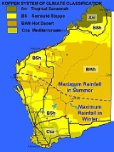
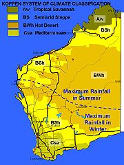
The climates of Western Australia
Tropic of Capricorn
The Tropic of Capricorn, or Southern tropic, marks the most southerly latitude on the Earth at which the Sun can be directly overhead. This event occurs at the December solstice, when the southern hemisphere is tilted towards the Sun to its maximum extent.Tropic of Capricorn is one of the five...
between the north, in which a summer rainfall pattern predominates, and the south, characterised by winter rainfall.
The northern part of the state, characterised by Monsoon
Monsoon
Monsoon is traditionally defined as a seasonal reversing wind accompanied by corresponding changes in precipitation, but is now used to describe seasonal changes in atmospheric circulation and precipitation associated with the asymmetric heating of land and sea...
al circulation, in the winter months from May to September is of generally warm dry offshore winds, drawn across the Inter-Tropical Convergence Zone by the low pressure systems of Monsoon Asia. In summer, from November to March, with the displacement of the Intertropical Convergence over northern Australia, the weather is characterised by humid tropical onshore airflows, coupled with thunderstorms and an occasional cyclone
Cyclone
In meteorology, a cyclone is an area of closed, circular fluid motion rotating in the same direction as the Earth. This is usually characterized by inward spiraling winds that rotate anticlockwise in the Northern Hemisphere and clockwise in the Southern Hemisphere of the Earth. Most large-scale...
, these weather patterns bringing the bulk of the rainfall of the region. The highest wind-gust recorded on the Australian mainland was 259 km/h at Mardi during tropical cyclone Trixie, in 1975 and Whim Creek has the record for the highest rainfall, at 747 mm in 24 hours, associated with a cyclone in 1898.
In the southern part of the state the bulk of rainfall comes from west to east moving cold frontal low pressure depressions, originating off the edge of the winter pack-ice
Drift ice
Drift ice is ice that floats on the surface of the water in cold regions, as opposed to fast ice, which is attached to a shore. Usually drift ice is carried along by winds and sea currents, hence its name, "drift ice"....
in the Southern Ocean
Southern Ocean
The Southern Ocean comprises the southernmost waters of the World Ocean, generally taken to be south of 60°S latitude and encircling Antarctica. It is usually regarded as the fourth-largest of the five principal oceanic divisions...
, south of South Africa. Cold southern airflows, wedging beneath humid north westerly winds triggers vertical instabilities, bringing this region the bulk of its rain between May and August. During the summer months these frontal depressions travel well to the south, leading to warm high pressure systems dominating the southern part of the state.
As a result the state is classified with five climates in the Köppen climate classification
Köppen climate classification
The Köppen climate classification is one of the most widely used climate classification systems. It was first published by Crimea German climatologist Wladimir Köppen in 1884, with several later modifications by Köppen himself, notably in 1918 and 1936...
s, ranging from Aw Tropical wet-dry climates in the Kimberley region of the state, through BSh Semiarid (summer rainfall) to the south of the Kimberley, BW Arid climates, covering the Great Sandy Desert
Great Sandy Desert
The Great Sandy Desert is a desert located in the North West of Western Australia straddling the Pilbara and southern Kimberley regions. It is the second largest desert in Australia after the Great Victoria Desert and encompasses an area of...
, Central Australian Desert, Gibson Desert
Gibson Desert
The Gibson Desert covers a large dry area in the state of Western Australia and is still largely in an almost "pristine" state. It is about in size, making it the 5th largest desert in Australia, after the Great Sandy, Great Victoria, Tanami and Simpson deserts.-Location and description:The Gibson...
and the Great Victoria Desert
Great Victoria Desert
The Great Victoria Desert is a barren and sparsely populated desert area of southern Australia.-Location and description:The Great Victoria is the biggest desert in Australia and consists of many small sandhills, grassland plains, areas with a closely packed surface of pebbles and salt lakes...
, BSh Semiarid (winter rainfall), from Shark Bay to the Nullabor, and then a Csa Mediterranean climate
Mediterranean climate
A Mediterranean climate is the climate typical of most of the lands in the Mediterranean Basin, and is a particular variety of subtropical climate...
from Northampton
Northampton, Western Australia
Northampton is a town north of Geraldton, in the Mid West region of Western Australia. At the 2006 census, the town had a population of 813. It is historic, with an outstanding National Trust building. The town lies on the North West Coastal Highway. Formerly named Gwalla after the location's...
to Esperance
Esperance, Western Australia
Esperance is a large town in the Goldfields-Esperance region of Western Australia, located on the Southern Ocean coastline approximately east-southeast of the state capital, Perth. The shire of Esperance is home to 9,536 people as of the 2006 census, its major industries are tourism, agriculture,...
and covering the Southwest of the state.
The Kimberley region
Between April and October the climate is characterised by dry months with clear blue skies, moderate daytime temperatures and cool nights. The "wet season" however, is hot and humid with monsoonal winds bringing consistent and sometimes torrential rain. Broome, (with a rainfall of 513 mm in 47 days) for instance has had 356 mm of rain in 24 hours. Cyclones forming off the coast, in the 1970s formed only twice a year and crossed the coast only every second year, although with global warming this frequency is increasing. The torrential rain swells the rivers through run-off, and the resulting floods in dry river beds can lead to loss of livestock, property damage and occasionally loss of life. Communities may be cut off through road flood damage. Prior to being dammed, the Order River delivered more than 50 million litres a second, past Wyndham (652 mm in 56 days) into the Cambridge Gulf.The Central and Goldfields region
This is a region of salt-lakes, sand-dune rides, and is covered with desert oaks and mulgas. Laverton for instance has an average rainfall of only 192 mm over 41 days in average, although this rainfall is extremely erratic, and the area can go without rainfall for nearly a year, and then receive the equivalent of its annual rainfall in only a few hours. On close to the centre of the Western Australian border Giles Meteorological StationGiles Weather Station
Giles Weather Station is located in Western Australia near the South Australian border, about West-South-West of Alice Springs and West of Uluru. It is the only staffed weather station within an area of about and is situated mid-continent and near the core of the subtropical jetstream...
records only 219 mm of rain over an average of 43 days. Whilst Laverton receives the bulk of its rain from frontal systems hat occasionally extend through to the Goldfields, Giles is generally dry from July through to September and gets the bulk of its rain from tropical cyclones which collapse into tropical depressions, bringing sudden rain into the interior.
The Gascoyne and Pilbara region
This semiarid region lies astride the summer and winter rainfall regimes. In the north Dampier, for instance, with 402 mm of rain over 23 days has its wettest months in January, February and March, whilst Carnarvon with 239 mm of rainfall over 45 days, peaking June and July. Like in the Kimberley, this region is characterised by an extreme tidal range, leaving the coast surrounded by mangroves and mudflats, which, again like the Kimberley, in earlier years were important as a source of wild pearls and oysters. Inland the river gorges are inclined to flash flooding with the occasional sudden downpours, giving sufficient water for sheep and cattle stations.The Southwest region
This region has cool wet winters, and hot dry summers, with rainfall decreasing and summer temperatures increasing with distance from the sea. The region ranges from Pemberton, located in the Karri Forest region of the extreme southwest corner of the state has an average rainfall of 1244 mm over 167 days, to Bencubbin in the northeast wheat belt with only 319 mm over 73 days. Coastal regions are generally free from frosts, although frost conditions on winter nights are not uncommon. The state is generally snow free throughout winter, although an occasional fall is reported once or twice a year on the Stirlings or Porongurups north of Albany (837 mm over 179 days). Snowfalls have been recorded as far north as Wongan Hills, and as late in the year as November. Perth is supposedly the second windiest city in the British Commonwealth (after Wellington, New Zealand), and it is not uncommon in winter to have wind-gusts of up to 135 km/h. Forested areas generally have the highest rainfall, and there is a marked rain shadowRain shadow
A rain shadow is a dry area on the lee side of a mountainous area. The mountains block the passage of rain-producing weather systems, casting a "shadow" of dryness behind them. As shown by the diagram to the right, the warm moist air is "pulled" by the prevailing winds over a mountain...
effect along the Darling Scarp, with the result that the rainfall pattern shows an area of higher rainfalls extending from Collie north to the Chittering Brook and Karnet.
Depletion of stratospheric ozone
The southern half of Western Australia is greatly affected by the depletion of atmospheric ozone. While the rate of increase in the size of the ozone hole is slowing, 2006 figures produced by NASA show that the size of the hole that year was the biggest on record, averaging 27.4 million square kilometers in extent. As a result the figures that suggest that 1/3 of Western Australians will in the course of their life suffer from skin cancers, has caused a huge change in popular behavior. From being a part of a nation of sun-loving beach-goers, Western Australians have adopted a habit of "slipping" on a shirt, "slopping" on a 15+ sunscreen and "slapping" on a hat. Unfortunately the effects of the ozone hole on Western Australian livestock, or on our native flora and fauna is much less understood. The increase in numbers of blind kangaroo suffering from ultraviolet caused cataracts has been recorded in local newspapers, but the overall effects has not been studied.Climate change and global warming
The International Panel on Climate Change has shown that the natural ecosystems can absorb approximately two tonnes of carbon dioxide per person per year. At the moment the world, through the burning of fossil fuels and the clearing of forests is emitting 6.8 tonnes of carbon dioxide per person per year, with the result that over the last century the concentration of carbon dioxide has gone from 280 parts per million to 380 parts per million, a change equivalent to that seen since the depths of the last Ice Age. While in Europe the average rate of emissions is currently about 10 tonnes per person, and the average in the US is over 20 tonnes, for Australia as a whole produces about 26 tonnes of greenhouse gas emissions per person.Western Australia emits 33.1 tonnes of net carbon dioxide equivalents (CO2-e) per capita, making the state one of the highest contributors per capita in the world.
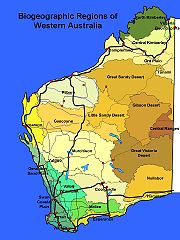
The biogeography of Western Australia
There are 25 biogeographic regions of 80 in the country, in the Interim Biogeographic Regions of Australia
Interim Biogeographic Regionalisation for Australia
The Interim Biogeographic Regionalisation for Australia is a biogeographic regionalisation of Australia developed by the Australian Government's Department of the Environment, Water, Heritage and the Arts...
(IBRA) system. The IBRA was developed in 1993-94 under the coordination of Environment Australia by the States and Territories as a basis for developing priorities for the Commonwealth in funding additions to the reserve system under the National Reserve System Cooperative Program, in order to ensure that a balance of representative biogeographic areas were preserved by National Parks and Nature Reserves.
The detailed IBRA analyses addressed:
- The representativeness of the existing reserve system;
- Biases in the existing reserve system;
- Major threatening processes within each IBRA region; and
- Identifying priority IBRA regions in urgent need of further reserve additions.
In Western Australia this involved small changes in the Carnarvon Shark Bay area which was added to the Geraldton Sandplain region, Extension of the Yalgoo Region to include part of the Carnarvon region, transfer of the Salmongum woodland region from the Coolgardie to the Mallee biogeographic region and minor changes to the Central Ranges outliers.
The Avon Wheatbelt
Avon Wheatbelt
Avon Wheatbelt is an Interim Biogeographic Regionalisation for Australia region in Western Australia and part of the larger Southwest Australia savanna ecoregion.-Further reading:...
This is an area of active drainage dissecting a Tertiary plateau in Yilgarn Craton. The gently undulating landscape of low relief has Proteaceous scrub-heaths, rich in endemics, on residual lateritic uplands and derived sandplains; mixed eucalypt, Allocasuarina huegeliana
Allocasuarina huegeliana
Allocasuarina huegeliana, commonly known as rock sheoak or sighing sheoak, is a tree in the family Casuarinaceae. Endemic to Western Australia, it occurs throughout the Wheatbelt. It is now especially common on road verges, where it sometimes forms thickets.Rock sheoak grows to a height of...
and Jam-York Gum woodlands on Quaternary alluvials and eluvials. The south eastern boundary has been modified incorporating a small portion into the Mallee region. The whole region has been extensively cleared for agriculture, and rapid dry-land salinity is a major problem.
The Carnarvon Region
Carnarvon (biogeographic region)
Carnarvon is an Interim Biogeographic Regionalisation for Australia region in Western Australia. This area is also referred to physiographically as the Carnarvon Basin, where it is a physiographic province of the larger West Australian Shield division....
The Carnarvon region comprises Quaternary alluvial, aeolian and marine sediments overlying Cretaceous strata. There is a mosaic of saline alluvial plains with samphire and saltbush low shrublands, Bowgada low woodland on sandy ridges and plains, Snakewood
Acacia xiphophylla
Acacia xiphophylla, commonly known as snakewood or snake-wood, is a tree in the family Fabaceae. Endemic to Western Australia, it occurs on saline semi-arid land in the Gascoyne River and Ashburton catchments east and north of Carnarvon....
scrubs on clay flats, and tree to shrub steppe over hummock grasslands on and between red sand dune fields. The Limestone strata are covered with Acacia startii and binervia
Acacia binervia
Acacia binervia, commonly known as the Coast Myall, is a wattle native to New South Wales and Victoria. It can grow as a shrub or as a tree reaching 16 m in height...
shrublands outcrop in the north, where extensive tidal flats in sheltered embayments support Mangal vegetation.
The Coolgardie Region
Coolgardie (biogeographic region)
Coolgardie is an Interim Biogeographic Regionalisation for Australia region and a World Wildlife Fund ecoregion consisting of an area of low hills and plains of infertile sandy soil in Western Australia. -Location and description:...
Granite strata of Yilgarn Craton characterises Coolgardie, with Archaean Greenstone intrusions in parallel belts. Drainage is arheic and occluded. Mallees and scrubs are found on sandplains associated with lateritised uplands, playas and granite outcrops. Diverse woodlands rich are in K strategy endemic eucalypts, on low greenstone hills, valley alluvials and broad plains of calcareous earths. In the west of the region, the scrubs are rich in endemic Proteaceae
Proteaceae
Proteaceae is a family of flowering plants distributed in the Southern Hemisphere. The family comprises about 80 genera with about 1600 species. Together with the Platanaceae and Nelumbonaceae they make up the order Proteales. Well known genera include Protea, Banksia, Embothrium, Grevillea,...
, in the east they are rich in endemic acacia
Acacia
Acacia is a genus of shrubs and trees belonging to the subfamily Mimosoideae of the family Fabaceae, first described in Africa by the Swedish botanist Carl Linnaeus in 1773. Many non-Australian species tend to be thorny, whereas the majority of Australian acacias are not...
s.
The Central Ranges
Central Ranges
Central Ranges is an Interim Biogeographic Regionalisation for Australia region in Western Australia, the Northern Territory and South Australia, and are a large part of the World Wide Fund for Nature Central Ranges xeric scrub ecoregion....
There are a high proportion of Proterozoic ranges and derived soil plains, interspersed with red Quaternary sandplains in this region. The sandplains support low open woodlands of either Desert Oak or Mulga
Mulga
Acacia aneura, commonly known as Mulga or True Mulga, is a shrub or small tree native to arid outback Australia of areas such as the Western Australian Mulga shrublands.-Description:...
over Triodia basedowii hummock grasslands. Low open woodlands of Ironwood (Acacia estrophiolata
Acacia estrophiolata
Acacia estrophiolata, commonly known as the Ironwood or Southern Ironwood, is a tree native to Central Australia.It is a graceful, pendulous shade tree, which grows from about 4-16 m tall and has a trunk with a diameter of up to about 0.45 m. Young plants are spiky leaved...
) and Corkwoods (Hakea
Hakea
Hakea is a genus of 149 species of shrubs and small trees in the Proteaceae, native to Australia. They are found throughout the country, with the highest species diversity being found in the south west of Western Australia....
spp.) are found over tussock and hummock grasses which often fringe the ranges. The ranges support mixed wattle scrub or Callitris glaucophylla woodlands again over hummock and tussock grasslands.
Dampierland
Dampierland
Dampierland is an Interim Biogeographic Regionalisation for Australia region in Western Australia. This area also is a distinct physiographic section of the larger Nullagine Platform province, which in turn is part of the larger West Australian Shield division.It is located in the West Kimberley ...
contains four distinct landforms.
- The Quaternary sandplain overlying Jurassic and Mesozoic sandstones is covered with PindanPindanPindan is a name given to the red-soil country of the south-western Kimberley region of Western Australia. The word “pindan” was first mentioned in print in August 1884 in the Perth Inquirer...
and with Hummock grasslands on hills. - Quaternary marine deposits are found on coastal plains, with MangalMangalMangal is the name for Turkish barbecue. In a more social context, it resembles braai of South Africa.Mangal is popular in Armenia, Azerbaijan, Iran, Iraq, Turkey, Israel, Pakistan, Kazakhstan, Uzbekistan and countries in the Levant...
, samphireSamphireSamphire is a name given to a number of very different edible plants that happen to grow in coastal areas.*Rock samphire, Crithmum maritimum is a coastal species with white flowers that grows in the United Kingdom...
- SporobolusSporobolusSporobolus is a genus of grasses in the family Poaceae. They are usually called dropseed grasses or sacaton grasses. They are typical prairie and savanna plants, and they occur in other types of open habitat in warmer climates....
grasslands, Melaleuca acacioides low forests, and SpinifexSpinifexSpinifex may refer to:* Spinifex , a genus of grass which is indigenous to the coastal areas of Australasia and Indonesia* Triodia , a hummock grass of arid Australia, covering twenty percent of the Australian continent ** Spinifex resin* Spinifex people, or Pila Nguru, an Australian...
- CrotalariaCrotalariaCrotalaria is a genus of herbaceous plants and woody shrubs in the Family Fabaceae commonly known as rattlepods. Some 600 or more species of Crotalaria are described worldwide, mostly from the tropics; at least 500 species are known from Africa. Some species of Crotalaria are grown as ornamentals...
strand communities. - Quaternary alluvial plains are associated with the Permian and Mesozoic sediments of Fitzroy Trough and support tree savannas of Crysopogon - DichanthiumDichanthiumDichanthium, also known as bluestem, is a genus of annual or perennial grass in the Poaceae family, found in Africa, temperate and tropical Asia, Australasia, Pacific islands, and North America and South America. It includes 59 species....
grasses with scattered Eucalyptus microthecaEucalyptus microthecaEucalyptus microtheca, commonly known as the coolibah, is a species of eucalypt native to Australia....
- Lysiphyllum cunninghamii. The Riparian forests of River Gum and Cadjeput fringe drainages along the Fitzroy River. - Devonian reef limestones in the north and east support sparse tree steppe over Triodia intermedia and T. wiseana hummock grasses and vine thicket elements.
The Esperance Plains
Esperance Plains
Esperance Plains, also known as Eyre Botanical District, is a biogeographic region in southern Western Australia. Located on the south coast between the Avon Wheatbelt and Hampton regions, and bordered to the north by the Mallee region, it is a plain punctuated by granite and quartz outcrops and...
Proteaceous Scrub and mallee heaths are found on the sandplain overlying Eocene sediments. This area is particularly rich in endemic speciess. Herbfield
Herbfield
Herbfields are plant communities dominated by herbaceous plants, especially forbs and grasses. They are found where climatic conditions do not allow large woody plants to grow, such as in subantarctic and alpine tundra environments...
s and heaths (rich in endemics) are found on abrupt granite and quartzite ranges that rise from the plain. Eucalypt woodlands occur in gullies and alluvial foot-slopes.
The Gascoyne
Gascoyne (biogeographic region)
Gascoyne is an Interim Biogeographic Regionalisation for Australia region in Western Australia and part of the Western Australian Mulga shrublands ecoregion .-Further reading:...
In the Gascoyne region rugged low Proterozoic sedimentary and granite ranges are divided by broad flat valleys. Open mulga woodlands occur on shallow earthy loams over hardpan on the plains, with mulga scrub and Eremophila
Eremophila (plant)
Eremophila is a genus of plants of the family Scrophulariaceae, with species known by the common names of Emu Bush, Poverty Bush or Fuchsia Bush. Currently, there are 215 recognised species, all of which are endemic to Australia...
shrublands on the shallow stony loams of the ranges. For the Carnegie Salient, in the east, it is characterised by extensive salt lake features supporting succulent steppes.
The Gibson Desert
Gibson Desert
The Gibson Desert covers a large dry area in the state of Western Australia and is still largely in an almost "pristine" state. It is about in size, making it the 5th largest desert in Australia, after the Great Sandy, Great Victoria, Tanami and Simpson deserts.-Location and description:The Gibson...
The Gibson Desert is basically a lateritised upland on flat-lying Jurassic and Cretaceous sandstones of Canning Basin. Mulga parkland over Triodia basedowii is found on lateritic "buckshot" plains. Mixed shrub steppe of Acacia
Acacia
Acacia is a genus of shrubs and trees belonging to the subfamily Mimosoideae of the family Fabaceae, first described in Africa by the Swedish botanist Carl Linnaeus in 1773. Many non-Australian species tend to be thorny, whereas the majority of Australian acacias are not...
, Hakea
Hakea
Hakea is a genus of 149 species of shrubs and small trees in the Proteaceae, native to Australia. They are found throughout the country, with the highest species diversity being found in the south west of Western Australia....
and Grevillea
Grevillea
Grevillea is a diverse genus of about 360 species of evergreen flowering plants in the protea family Proteaceae, native to Australia, New Guinea, New Caledonia, and Sulawesi. It was named in honour of Charles Francis Greville. The species range from prostrate shrubs less than 0.5 m tall to trees...
over Triodia pungens occurs on red sand plains and dune fields. Lateritic uplands support shrub steppe in the north and mulga scrub in the south. Quaternary alluvia that are associated with palaeo-drainage features support Coolabah
Coolabah
Coolabah may refer to:-* Eucalyptus coolabah, a species of Eucalyptus, an Australian steamship in service 1952-56...
woodlands over bunch grasses.
The Geraldton Sandplain
Geraldton Sandplains
Geraldton Sandplains is an Interim Biogeographic Regionalisation for Australia region in Western Australia and part of the larger Southwest Australia savanna ecoregion.It has two sub regions: -* Geraldton Hills sub region* Lesuer sub region...
The Geraldton Sandplain is a highly biodiverse region. Vegetation is mainly of proteaceous scrub-heaths, rich in endemics, on the sandy earths of an extensive, undulating, lateritic sandplain mantling Permian to Cretaceous strata. Extensive York Gum and Jam woodlands occur on outwash plains associated drainage.
The Great Sandy Desert
Great Sandy Desert
The Great Sandy Desert is a desert located in the North West of Western Australia straddling the Pilbara and southern Kimberley regions. It is the second largest desert in Australia after the Great Victoria Desert and encompasses an area of...
The Great Sandy Desert is mainly a tree steppe grading to shrub steppe in south. It comprises open hummock grassland of Triodia pungens and Plectrachne schinzii with scattered trees of Owenia reticulata and Bloodwood
Bloodwood
Bloodwood has several meanings. It is the name of a dark red wood, from South America. It is also a common name for several unrelated groups of trees, for instance:* Brosimum paraense, a tree found in Central and South America...
s, and shrubs of Acacia
Acacia
Acacia is a genus of shrubs and trees belonging to the subfamily Mimosoideae of the family Fabaceae, first described in Africa by the Swedish botanist Carl Linnaeus in 1773. Many non-Australian species tend to be thorny, whereas the majority of Australian acacias are not...
species, Grevillea wickhamii
Grevillea wickhamii
Grevillea wickhamii is an erect shrub or small tree to 6 metres in height which is endemic to Western Australia, Northern Territory and Queensland...
and Grevillia refracta, on Quaternary red longitudinal sand dune fields overlying Jurassic and Cretaceous sandstones of the Canning, Centralian, Arunta and Armadeus Basins. Casuarina decaisneana (Desert Oak) occurs in the far east of the region. Gently undulating lateritised uplands support shrub steppe such as Acacia pachycarpa shrublands over Triodia pungens hummock grass. Calcrete and evaporite surfaces are associated with occluded palaeo-drainage systems that traverse the desert; these include extensive salt lake chains with samphire low shrublands, and Melaleuca glomerata - Melaleuca lasiandra shrublands.
The Great Victoria Desert
Great Victoria Desert
The Great Victoria Desert is a barren and sparsely populated desert area of southern Australia.-Location and description:The Great Victoria is the biggest desert in Australia and consists of many small sandhills, grassland plains, areas with a closely packed surface of pebbles and salt lakes...
The Great Victoria Desert is an arid active sand-ridge desert of deep Quaternary aeolian sands overlying Permian and Mesozoic strata of the Officer Basin. Between sand-dune ridges there is a tree steppe of Eucalyptus gongylocarpa, Mulga and Eucalyptus youngiana
Eucalyptus youngiana
Eucalyptus youngiana, commonly known as Large-fruited Mallee, Ooldea Mallee and Yarldarlba, is a tree that occurs in arid and semi-arid areas of southern Western Australia and South Australia.-Description:...
over hummock grassland dominated by Triodia basedowii.
The Hampton Region
Hampton (biogeographic region)
Hampton is an Interim Biogeographic Regionalisation for Australia region in Western Australia.-Further reading:* Thackway, R and I D Cresswell An interim biogeographic regionalisation for Australia : a framework for setting priorities in the National Reserves System Cooperative Program Version...
The Hampton Region comprises Quaternary marine dune systems on a coastal plain of the Eucla Basin, backed by stranded limestone scarp. Areas of marine sand are also perched along the top edge of the scarp. Various mallee communities dominate the limestone scree slopes and pavements, as well as the sandy surfaces. Alluvial and calcareous plains are found below the scarp support eucalypt woodlands and Myall
Myall
Myalls are any of a group of closely related and very similar species of Acacia:* A. papyrocarpa, commonly known as western myall;** a weeping form of the species, commonly known as water myall;...
open low woodlands.
The Jarrah Woodlands
Jarrah Forest
Jarrah Forest is an Interim Biogeographic Regionalisation for Australia region in Western Australia.-Location and description:The ecoregion stands on the 300m high Yilgarn block inland plateau and includes wooded valleys such as those of Western Australia's Murray River and the Helena River near...
The Duricrusted plateau of the western edge of the Yilgarn Craton is characterised by Jarrah
Jarrah
Eucalyptus marginata is one of the most common species of Eucalyptus tree in the southwest of Western Australia. The tree and the wood are usually referred to by the Aboriginal name Jarrah...
-Marri
Corymbia calophylla
Corymbia calophylla is a bloodwood native to Western Australia. Common names include Marri and Port Gregory Gum, and a long standing usage has been Red Gum due to the red gum effusions often found on trunks.It is distinctive among bloodwoods for its very large buds and fruit Corymbia calophylla...
forest on laterite gravels and, in the eastern part, by Marri-Wandoo woodlands on clayey soils. Eluvial and alluvial deposits support Agonis shrublands. In areas of Mesozoic sediments, Jarrah forests occur in a mosaic with a variety of species-rich shrublands. This area has been heavily logged for timber, Jarrah here being largely regrowth.
The Little Sandy Desert
Little Sandy Desert
The Little Sandy Desert is a desert located in Western Australia south of the Great Sandy Desert and west of the Gibson Desert. It is to the east of Great Northern Highway south of Newman and approximately 200 kilometres north of Wiluna...
In this region red Quaternary dune fields have abrupt Proterozoic sandstone ranges of Bangemall Basin. There is a shrub steppe of acacias, Thryptomene and grevilleas over Plectrachne schinzii on sandy surfaces. Sparse shrub-steppe is found over Triodia basedowii on stony hills, with River Gum communities and bunch grasslands on alluvial deposits in and associated with ranges.
The Mallee Region
Mallee (biogeographic region)
Mallee, also known as Roe Botanical District, is a biogeographic region in southern Western Australia. Located between the Esperance Plains, Avon Wheatbelt and Coolgardie regions, it has a low, gently undulating topography, a semi-arid mediterranean climate, and extensive Eucalyptus mallee...
This region has been re-defined to include an area from the Coolgardie Bioregion – the area between Lake Hope, Forrestiana and Mount Holland, which comprises Salmon Gum and Morrell
Morrell
Morrell is a surname, and may refer to:* Andy Morrell, English footballer* Arthur Fleming Morrell, English naval officer* Benjamin Morrell, American sealing captain and explorer, after whom is named:...
woodlands on greenstone, with smaller areas of mallee and Acacia / Casuarina thicket on sandplains. The south-eastern part of Yilgarn Craton is gently undulating, with partially occluded drainage. Vegetation is mainly mallee over myrtaceous-proteaceous heaths on duplex (sand over clay) soils. Melaleuca
Melaleuca
Melaleuca is a genus of plants in the myrtle family Myrtaceae known for its natural soothing and cleansing properties. There are well over 200 recognised species, most of which are endemic to Australia...
shrublands characterise alluvia, and Halosarcia low shrublands occur on saline alluvium. A mosaic of mixed eucalypt woodlands and mallee occurs on calcareous earth plains and sandplains overlying Eocene limestone strata in the east.
The Murchison
Murchison (biogeographic region)
Murchison is an Interim Biogeographic Regionalisation for Australia region in Western Australia and part of the Western Australian Mulga shrublands ecoregion .-Further reading:...
This arid region of Mulga low woodlands, is often rich in ephemerals, on outcrop hardpan washplains and fine-textured Quaternary alluvial and eluvial surfaces mantling granitic and greenstone strata of the northern part of the Yilgarn Craton. Surfaces are associated with the occluded drainage occur throughout with hummock grasslands on Quaternary sandplains, saltbush shrublands on calcareous soils and Halosarcia low shrublands on saline alluvia. Areas of red sandplains are covered with mallee-mulga parkland over hummock grasslands occurring widely in the east.
The Northern Kimberley
Northern Kimberley
Northern Kimberley is an Interim Biogeographic Regionalisation for Australia region in Western Australia.-Further reading:* Thackway, R and I D Cresswell An interim biogeographic regionalisation for Australia : a framework for setting priorities in the National Reserves System Cooperative Program...
This is tissected plateau of Kimberley Basin, covered with savanna woodland of Woolybutt and Darwin Stringybark over high Sorghum grasses and Plectrachne schinzii hummock grasses on shallow sandy soils on outcropping Proterozoic siliceous sandstone strata. Savanna woodlands on Eucalyptus tectifica - Eucalyptus grandiflora alliance over high Sorghum grasses on red and yellow earths mantling basic Proterozoic volcanics. Riparian closed forests of paperbark trees and Pandanus occur along drainage lines. Extensive Mangal
Mangal
Mangal is the name for Turkish barbecue. In a more social context, it resembles braai of South Africa.Mangal is popular in Armenia, Azerbaijan, Iran, Iraq, Turkey, Israel, Pakistan, Kazakhstan, Uzbekistan and countries in the Levant...
occurs in estuaries and sheltered embayments. Numerous small patches of monsoon rainforest are scattered through the district.
The Nullarbor
The Nullarbor is a Tertiary limestone plain with subdued arid karst features. Bluebush
Bluebush
-Plants:* Acacia brachybotrya of Australia* Acacia caesiella of Australia* Chenopodium species in Australia* Diospyros lycioides of Africa* Maireana, the bluebushes proper...
- Saltbush steppe are found widely in central areas, a low open woodlands of Myall over bluebush is found in peripheral areas, including Myoporum platycarpum and Eucalyptus oleosa
Eucalyptus oleosa
Eucalyptus oleosa, red mallee, is a native tree of Australia. The leaves were once harvested for the production of cineole based eucalyptus oil. These days Eucalyptus cneorifolia is used because of a higher oil content in new growth....
in the east and west.
The Ord Victoria Plain
Ord Victoria Plain
Ord Victoria Plain is an Interim Biogeographic Regionalisation for Australia region in Western Australia. and Northern Territory.-Location and description:...
s
Here level to gently undulating plains with scattered hills are found on Cambrian volcanics and Proterozoic sedimentary rocks; vertosols on plains and predominantly skeletal soils on hills; grassland with scattered Bloodwood
Bloodwood
Bloodwood has several meanings. It is the name of a dark red wood, from South America. It is also a common name for several unrelated groups of trees, for instance:* Brosimum paraense, a tree found in Central and South America...
and Snappy Gum with spinifex and annual grasses. The climate is of dry hot tropical, semi-arid summer rainfall. The lithological mosaic has three main components:
- Abrupt Proterozoic and Phanerozoic ranges and scattered hills mantled by shallow sand and loam soils supporting TriodiaTriodia (plant genus)Triodia is a large genus of hummock-forming grass endemic to Australia; they are commonly known as spinifex, although they are not a part of the coastal genus Spinifex. There are currently 64 recognised species...
hummock grasslands with sparse low trees. - Cambrian volcanics and limestones form extensive plains with short grass (Enneapogon spp.) on dry calcareous soils and medium-height grassland communities (AstreblaAstreblaAstrebla is a small genus of xerophytic grasses endemic to Australia. They are commonly known as Mitchell Grass.Species in this genera are:*Astrebla elymoides; Hoop Mitchell Grass*Astrebla lappacea; Curly Mitchell Grass...
and DichanthiumDichanthiumDichanthium, also known as bluestem, is a genus of annual or perennial grass in the Poaceae family, found in Africa, temperate and tropical Asia, Australasia, Pacific islands, and North America and South America. It includes 59 species....
) on cracking clays. Riparian forests of River Gums fringe drainage lines. - In the south-west, Phanerozoic strata are expressed as often lateritised upland sandplains with sparse trees. This component recurs as the Sturt Plateau Region in central Northern Territory.
The Pilbara
There are four major components to the Pilbara Craton.
- Hamersley. Mountainous area of Proterozoic sedimentary ranges and plateaux with Mulga low woodland over bunch grasses are found on fine textured soils and Snappy Gum over Triodia brizoides on skeletal sandy soils of the ranges.
- The Fortescue Plains. This area comprises alluvial plains and river frontages. Salt marsh, mulga-bunch grass, and short grass communities are found on alluvial plains. River Gum woodlands fringe the drainage lines. This is the northern limit of Mulga (Acacia aneura).
- Chichester. Archaean granite and basalt plains support shrub steppe characterised by Acacia pyrifolia over Triodia pungens hummock grasses. Snappy Gum tree steppes occur on ranges.
- Roebourne. Quaternary alluvial plains are found with a grass savanna of mixed bunch and hummock grasses, and dwarf shrub steppe of Acacia translucens over Triodia pungens. SamphireSamphireSamphire is a name given to a number of very different edible plants that happen to grow in coastal areas.*Rock samphire, Crithmum maritimum is a coastal species with white flowers that grows in the United Kingdom...
, SporobolusSporobolusSporobolus is a genus of grasses in the family Poaceae. They are usually called dropseed grasses or sacaton grasses. They are typical prairie and savanna plants, and they occur in other types of open habitat in warmer climates....
and MangalMangalMangal is the name for Turkish barbecue. In a more social context, it resembles braai of South Africa.Mangal is popular in Armenia, Azerbaijan, Iran, Iraq, Turkey, Israel, Pakistan, Kazakhstan, Uzbekistan and countries in the Levant...
occur on marine alluvial flats.
The Swan Coastal Plain
This is arguably the most damaged ecosystem in the state. This is a low lying coastal plain, mainly covered with Tuart-Banksia
Banksia
Banksia is a genus of around 170 species in the plant family Proteaceae. These Australian wildflowers and popular garden plants are easily recognised by their characteristic flower spikes and fruiting "cones" and heads. When it comes to size, banksias range from prostrate woody shrubs to trees up...
woodlands. It is dominated by Banksia or Tuart on sandy soils, Allocasuarina obesa on outwash plains, and paperbark in numerous former swampy areas. In the east, the plain rises to duricrusted Mesozoic sediments dominated by Jarrah
Jarrah
Eucalyptus marginata is one of the most common species of Eucalyptus tree in the southwest of Western Australia. The tree and the wood are usually referred to by the Aboriginal name Jarrah...
woodland. Three phases of marine sand dune development provide relief. The outwash plains, once dominated by Allocasuarina obesa-marri
Corymbia calophylla
Corymbia calophylla is a bloodwood native to Western Australia. Common names include Marri and Port Gregory Gum, and a long standing usage has been Red Gum due to the red gum effusions often found on trunks.It is distinctive among bloodwoods for its very large buds and fruit Corymbia calophylla...
woodlands and Melaleuca
Melaleuca
Melaleuca is a genus of plants in the myrtle family Myrtaceae known for its natural soothing and cleansing properties. There are well over 200 recognised species, most of which are endemic to Australia...
shrublands, are extensive only in the southern part of the region.
The Tanami
Tanami Desert
The Tanami Desert is a desert in northern Australia situated in the Northern Territory. It has a rocky terrain with small hills. The Tanami was the Northern Territory's final frontier and was not fully explored until well into the twentieth century...
The Tanami region is of mainly red Quaternary sandplains overlying Permian and Proterozoic strata which are exposed locally as hills and ranges. The sandplains support mixed shrub steppes of Hakea suberea, desert bloodwoods, acacia
Acacia
Acacia is a genus of shrubs and trees belonging to the subfamily Mimosoideae of the family Fabaceae, first described in Africa by the Swedish botanist Carl Linnaeus in 1773. Many non-Australian species tend to be thorny, whereas the majority of Australian acacias are not...
s and grevillea
Grevillea
Grevillea is a diverse genus of about 360 species of evergreen flowering plants in the protea family Proteaceae, native to Australia, New Guinea, New Caledonia, and Sulawesi. It was named in honour of Charles Francis Greville. The species range from prostrate shrubs less than 0.5 m tall to trees...
s over Triodia pungens hummock grasslands. Wattle scrub over Triodia pungens hummock grass communities occur on the ranges. Alluvial and lacustrine calcareous deposits occur throughout. In the north they are associated with Sturt Creek drainage, and support Crysopogon and Iseilema
Iseilema
Iseilema is a genus of grass in the Poaceae family.- External links :*...
short-grasslands often as savannas with River Gum.
The Victoria Bonaparte
Victoria Bonaparte
Victoria Bonaparte is an Interim Biogeographic Regionalisation for Australia region in the Northern Territory and Western Australia.-Further reading:...
Phanerozoic strata of the Bonaparte Basin in the north-western part are mantled by Quaternary marine sediments supporting Samphire
Samphire
Samphire is a name given to a number of very different edible plants that happen to grow in coastal areas.*Rock samphire, Crithmum maritimum is a coastal species with white flowers that grows in the United Kingdom...
- Sporobolus
Sporobolus
Sporobolus is a genus of grasses in the family Poaceae. They are usually called dropseed grasses or sacaton grasses. They are typical prairie and savanna plants, and they occur in other types of open habitat in warmer climates....
grasslands and mangal, and by red earth plains and black soil plains with an open savanna of high grasses. Outcrops of Devonian limestone karst in the west support tree steppe and vine thicket. Plateaux and abrupt ranges of Proterozoic sandstone, known as the Victoria Plateau, occur in the south and east, and are partially mantled by skeletal sandy soils with low tree savannas and hummock grasslands. In the south east there are limited areas of gently undulating terrain on a variety of sedimentary rocks supporting low Snappy Gum over hummock grasslands and also of gently sloping floodplains supporting Melaleuca minutifolia low woodland over annual sorghum
Sorghum
Sorghum is a genus of numerous species of grasses, one of which is raised for grain and many of which are used as fodder plants either cultivated or as part of pasture. The plants are cultivated in warmer climates worldwide. Species are native to tropical and subtropical regions of all continents...
s.
The Warren
Warren (biogeographic region)
Warren, also known as Karri Forest Region and the Jarrah-Karri forest and shrublands ecoregion, is a biogeographic region in southern Western Australia. Located in the southwest corner of Western Australia between Cape Naturaliste and Albany, it is bordered to the north and east by the Jarrah...
The Warren region is of dissected undulating country of the Leeuwin Complex and Albany Orogen with a wet Mediterranean climate, with loamy soils supporting Karri forest, laterites supporting Jarrah-Marri forest, leached sandy soils in depressions and plains supporting paperbark-sedge swamps, and Holocene marine dunes are covered with Agonis flexuosa
Agonis flexuosa
Agonis flexuosa is a species of tree that grows in the south west of Western Australia. It is easily the most common of the Agonis species, and is one of the most recognisable trees of Western Australia, being commonly grown in parks and on road verges in Perth.The species is commonly known as...
woodlands.
The Yalgoo Region
Yalgoo (biogeographic region)
Yalgoo is an Interim Biogeographic Regionalisation for Australia region in Western Australia and part of the larger Southwest Australia savanna ecoregion.In the IBRA system it has the code of , and it has two sub-regions:...
This region is an interzone between South-western Bioregions and Murchison. It is characterised by low woodlands to open woodlands of Eucalyptus
Eucalyptus
Eucalyptus is a diverse genus of flowering trees in the myrtle family, Myrtaceae. Members of the genus dominate the tree flora of Australia...
, Acacia
Acacia
Acacia is a genus of shrubs and trees belonging to the subfamily Mimosoideae of the family Fabaceae, first described in Africa by the Swedish botanist Carl Linnaeus in 1773. Many non-Australian species tend to be thorny, whereas the majority of Australian acacias are not...
and Callitris
Callitris
Callitris is a genus of coniferous trees in the Cupressaceae . There are 15 species in the genus, of which 13 are native to Australia and the other two native to New Caledonia. Traditionally the most widely used common name is cypress-pine, a name shared by the closely related genus Actinostrobus...
on red sandy plains of the Western Yilgarn Craton and southern Carnarvon Basin. The latter has a basement of Phanerozoic sediments. This Bioregion has been extended westwards to the boundary of the South-west Botanical Province, so that it now includes the Toolonga Plateau of the southern Carnarvon Basin.
Semi-arid to arid, warm, Mediterranean climate. Mulga
Mulga
Acacia aneura, commonly known as Mulga or True Mulga, is a shrub or small tree native to arid outback Australia of areas such as the Western Australian Mulga shrublands.-Description:...
, Callitris
Callitris
Callitris is a genus of coniferous trees in the Cupressaceae . There are 15 species in the genus, of which 13 are native to Australia and the other two native to New Caledonia. Traditionally the most widely used common name is cypress-pine, a name shared by the closely related genus Actinostrobus...
- Eucalyptus salubris
Eucalyptus salubris
Eucalyptus salubris, commonly known as Gimlet, Fluted Gum Tree, Gimlet Gum and Silver-topped Gimlet, is a gum tree endemic to low-rainfall areas of the wheatbelt and goldfields regions of Western Australia.-Description:...
, and Bowgada
Bowgada
Acacia ramulosa var. linophylla, commonly known as bowgada, wanderry mulga, horse mulga or sometimes wanyu, is a tree in the family Fabaceae...
open woodlands and scrubs on earth to sandy-earth plains in the western Yilgarn Craton. Rich in ephemerals.
Indigenous practices
The Western Australian environment was a creation of the indigenous NoongarNoongar
The Noongar are an indigenous Australian people who live in the south-west corner of Western Australia from Geraldton on the west coast to Esperance on the south coast...
, Yamatji
Yamatji
Yamatji is a name commonly used by Aboriginal people in the Murchison and Gascoyne regions of Western Australia to refer to themselves, and sometimes also to Aboriginal people generally, when speaking English. The word comes from the Wajarri language where it has the meaning 'man' or 'human being'...
, Wangai
Wangai
Wangai, Wongai or Wankai is the name given by themselves to the 26 Aboriginal groups of the Goldfields of Western Australia. It comes from the word meaning "Speaker"...
, Ngaanyatjarra
Ngaanyatjarra
Ngaanyatjarra is an Indigenous Australian cultural group in the Western Desert, Central Australia.-Meaning and origin of the name:Ngaanya literally means 'this' and -tjarra means 'with/having' ; the compound term means 'those that use "ngaanya" to say "this"'...
and Kimberley cultures. In particular, firestick farming which through mosaic burning returned important nutrients to the soil, encouraged plant germination of indigenous pyrogenic species, and through accelerating plant growth increased the carrying capacity of the natural environment for indigenous fauna, reshaped the whole of Western Australia over the last 70,000 years. Many of the sites later to develop as European settlements had been Aboriginal meeting-grounds or campsites for a long time. Major roads too were located on Aboriginal trade routes and major hunting trails. These were used by Aboriginal guides and black-trackers who led European explorers to the most important local water supplies.
Unfortunately these were often fenced for sheep and cattle runs, and local Aboriginal groups excluded thereafter, trees cleared and local fauna shot. Nevertheless many Aboriginal people subsequently found employment as shepherds or domestic servants in the new European Australian economy.
Today, Europeans have monopolised most of the lands with temperate wet climates. In Semiarid areas, the existence of a long-lived pastoral industry formerly dependent on Agricultural labour, enabled Aboriginal people to maintain traditional connections to country to a far greater degree, whilst in Arid areas European settlements were not to develop, and traditional hunting and gathering continued to early modern times.
European practices
The geography of European settlement began as a result of the attempt to exclude the French from the possession of the Western third of the continent. The line drawn between what was originally New Holland and what is now called "the Eastern States" stemmed from the Treaty of TordesillasTreaty of Tordesillas
The Treaty of Tordesillas , signed at Tordesillas , , divided the newly discovered lands outside Europe between Spain and Portugal along a meridian 370 leagueswest of the Cape Verde islands...
(1494), when the pope in adjudicating the territorial claims of Spain and Portugal, gave the Portuguese the East Indies and Spain, America and the Philippines. Holland, in taking possession of the Portuguese possessions in the Indies, with the fall of Malacca, claimed New Holland, as justified by the extended terms of that treaty. Cook, in claiming Eastern Australia for the British crown at Possession Island, only took the Spanish half of the continent, despite claims to the contrary. During and after the Napoleonic War, there was concerns that France would assume responsibility of Holland's Australian possessions, as she had temporarily done so in the Indies.
To prevent French claims, Governor Darling dispatched Major Edmund Lockyer, in 1827, in the brig Amity, to assume possession for the English crown of New Holland, at King George Sound, a natural strategic harbour. Two years later, Governor James Stirling
James Stirling (Australian governor)
Admiral Sir James Stirling RN was a British naval officer and colonial administrator. His enthusiasm and persistence persuaded the British Government to establish the Swan River Colony and he became the first Governor and Commander-in-Chief of Western Australia...
, established Perth, as the capital of the Swan River Company settlement, beginning the human settlement geography of Western Australia. Stirling, as a naval man, chose three sites that were easily defensible as the major towns for the colony. Fremantle, situated beneath the Monument, was to be the port, Perth, surrounded by water on three sides, with the barracks defending its western entrance, was to be the capital, and Guildford, also surrounded by water to the west south and north (the loop of the Swan and Helena Rivers), was to be the agricultural centre. Similar easily defended sites were chosen in the case of Australind and Bunbury, and Augusta. No account was taken of the wishes or desires of the indigenous Aboriginal people, who were progressively excluded from traditional lands owned by them.
At first all transport was by boat, and so settlers were keen to ensure that their properties had some river frontage. This meant that original land grants all were long and narrow, with the narrowest end facing the river (see Land Grants in the Swan River Colony
Land grants in the Swan River Colony
The Swan River Colony, established in June 1829, was the only British colony in Australia established on the basis of land grants to settlers. Under the conditions stipulated by the Colonial Office, settlers would be granted land in proportion to the value of assets and labour that they brought to...
).
Subsequent settlements tended to follow Aboriginal tracks to sources of fresh water. Thus Albany Highway crossed the river at the fords of Matta Garrup (=Leg Deep Place), now known as the Causeway, going south to Thomas Peel's lands along the Murray, in Pinjareb country. Settlements developed at Kelmscott and Armadale.
Early settlement fanned out from these centres.
Political Geography
- For the evolution of the Boundaries of Western Australia - see States and territories of AustraliaStates and territories of AustraliaThe Commonwealth of Australia is a union of six states and various territories. The Australian mainland is made up of five states and three territories, with the sixth state of Tasmania being made up of islands. In addition there are six island territories, known as external territories, and a...
and Territorial evolution of AustraliaTerritorial evolution of AustraliaThis is a list of the evolution of the borders of the colonies and later states of Australia. It lists each change to the internal and external borders of Australia before and after Federation.-Pre-Federation:26 January 178816 July 18253 December 1825...
See also
Australian context:-- Geology of AustraliaGeology of AustraliaAustralia is a continent situated on the Indo-Australian Plate.The geology of Australia includes virtually all known rock types and from all geological time periods spanning over 3.8 billion years of the Earth's history.-Components:...
Local features:-
- List of islands of Western Australia, A-C and numerals and subsequent sections
- List of lakes in Western Australia, A-C and subsequent sections
- List of rocks in Western Australia
- List of watercourses in Western Australia
Regional divisions:-
- Interim Biogeographic Regionalisation for AustraliaInterim Biogeographic Regionalisation for AustraliaThe Interim Biogeographic Regionalisation for Australia is a biogeographic regionalisation of Australia developed by the Australian Government's Department of the Environment, Water, Heritage and the Arts...
- Regions of Western AustraliaRegions of Western AustraliaRegionalisations of Western Australia are systems by which Western Australia is divided into distinct geographic regions. The most commonly known regionalisation is the governmental division of the state into regions for economic development purposes, of which there are nine.Other regionalisations...
Further reading
- Gentilli, J (editor) (1979) Western landscapes Nedlands, W.A. University of Western Australia Press for the Education Committee of the 150th Anniversary Celebrations; Sesquicentenary Celebrations SeriesSesquicentenary Celebrations SeriesThe Sesquicentenary Celebrations Series is a series of books published by University of Western Australia Press for the 150th Anniversary Celebrations of Western Australia in 1979 - widely promoted as 'WAY 1979' at that time....
ISBN 085564155X - Jarvis, Neil (editor) (1986) Western Australia, an atlas of human endeavour Perth, W.A : Dept. of Lands and Surveys in association with the Education Dept. of Western Australia. 2nd ed. ISBN 0730900827 (first edition 1979)
Historic texts
- Jutson, J.T. (1914) An outline of the physiographical geology (physiography) of Western Australia Perth, W.A.: Government Printer. Bulletin (Geological Survey of Western Australia); no. 61.