

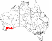
Mallee (biogeographic region)
Encyclopedia
Biogeography
Biogeography is the study of the distribution of species , organisms, and ecosystems in space and through geological time. Organisms and biological communities vary in a highly regular fashion along geographic gradients of latitude, elevation, isolation and habitat area...
region in southern Western Australia
Western Australia
Western Australia is a state of Australia, occupying the entire western third of the Australian continent. It is bounded by the Indian Ocean to the north and west, the Great Australian Bight and Indian Ocean to the south, the Northern Territory to the north-east and South Australia to the south-east...
. Located between the Esperance Plains
Esperance Plains
Esperance Plains, also known as Eyre Botanical District, is a biogeographic region in southern Western Australia. Located on the south coast between the Avon Wheatbelt and Hampton regions, and bordered to the north by the Mallee region, it is a plain punctuated by granite and quartz outcrops and...
, Avon Wheatbelt
Avon Wheatbelt
Avon Wheatbelt is an Interim Biogeographic Regionalisation for Australia region in Western Australia and part of the larger Southwest Australia savanna ecoregion.-Further reading:...
and Coolgardie
Coolgardie (biogeographic region)
Coolgardie is an Interim Biogeographic Regionalisation for Australia region and a World Wildlife Fund ecoregion consisting of an area of low hills and plains of infertile sandy soil in Western Australia. -Location and description:...
regions, it has a low, gently undulating topography
Topography
Topography is the study of Earth's surface shape and features or those ofplanets, moons, and asteroids...
, a semi-arid mediterranean climate
Mediterranean climate
A Mediterranean climate is the climate typical of most of the lands in the Mediterranean Basin, and is a particular variety of subtropical climate...
, and extensive Eucalyptus
Eucalyptus
Eucalyptus is a diverse genus of flowering trees in the myrtle family, Myrtaceae. Members of the genus dominate the tree flora of Australia...
mallee
Mallee (habit)
Mallee is the growth habit of certain eucalypt species that grow with multiple stems springing from an underground lignotuber, usually to a height of no more than ten metres...
vegetation. About half of the region has been cleared for intensive agriculture. Recognised as a region under the Interim Biogeographic Regionalisation for Australia
Interim Biogeographic Regionalisation for Australia
The Interim Biogeographic Regionalisation for Australia is a biogeographic regionalisation of Australia developed by the Australian Government's Department of the Environment, Water, Heritage and the Arts...
(IBRA), it was first defined by John Stanley Beard
John Stanley Beard
John Stanley Beard was a British-born forester and ecologist who resided in Australia. While working with the Forestry Division in Trinidad and Tobago during the 1940s, Beard developed a system of forest classification for Tropical America and described the forests of Trinidad, Tobago, and the...
in 1980.
Geography and geology
The Mallee region has a complex shape with tortuous boundaries, but may be roughly approximated as the triangular area south of a line from Bruce RockBruce Rock, Western Australia
Bruce Rock is a town located in the Eastern Wheatbelt region of Western Australia, approximately east of Perth and southwest of Merredin. It is the main town in the Shire of Bruce Rock....
to Eyre, but not within 40 kilometres (25 mi) of the south coast, except at its eastern limits. It has an area of about 79000 square kilometres (31000 mi²), making it about a quarter of the South West Botanic Province, 3% of the state, and 1% of Australia. It is bounded to the south by the Esperance Plains
Esperance Plains
Esperance Plains, also known as Eyre Botanical District, is a biogeographic region in southern Western Australia. Located on the south coast between the Avon Wheatbelt and Hampton regions, and bordered to the north by the Mallee region, it is a plain punctuated by granite and quartz outcrops and...
region; to the west and northwest by the Avon Wheatbelt
Avon Wheatbelt
Avon Wheatbelt is an Interim Biogeographic Regionalisation for Australia region in Western Australia and part of the larger Southwest Australia savanna ecoregion.-Further reading:...
region; and to the east by the Coolgardie
Coolgardie (biogeographic region)
Coolgardie is an Interim Biogeographic Regionalisation for Australia region and a World Wildlife Fund ecoregion consisting of an area of low hills and plains of infertile sandy soil in Western Australia. -Location and description:...
region.
There are a number of small towns in the west of the region, where wheat is grown. These include Gnowangerup
Gnowangerup, Western Australia
Gnowangerup is a town located south east of Katanning in the Great Southern region of Western Australia. The townsite was first gazetted in 1908 under the spelling of Ngowangerupp. Local dissatisfaction with this spelling led to it being altered to Gnowangerup in 1913.A branch railway from...
, Lake Grace
Lake Grace, Western Australia
-Natural disasters:In late 2005 and early 2006, Lake Grace experienced two natural disasters. The first was a hail storm on 16 October 2005, which destroyed 500 hectares of wheat and barley crop and damaged a further 5,500 hectares, with some farmers reporting fields covered by up to...
, Newdegate
Newdegate, Western Australia
Newdegate is a townsite in the great southern agricultural region, 399 km south-east of Perth and 52 km east of Lake Grace in Western Australia. The townsite was gazetted in 1925 and honours Sir Francis Newdegate, the Governor of Western Australia from 1920 to 1924...
, Kondinin
Kondinin, Western Australia
Kondinin is a town located in the Eastern Wheatbelt region of Western Australia, east of the state capital, Perth via the Brookton Highway and State Route 40 between Corrigin and Hyden. It is the main town in the Shire of Kondinin...
and Hyden
Hyden, Western Australia
The town of Hyden is located 339 km east of Perth, Western Australia in the Shire of Kondinin. Hyden is home to Wave Rock and Mulka's Cave, both popular local tourist attractions....
. Also of note is the tourist attraction Wave Rock
Wave Rock
Wave Rock is a natural rock formation located east of the small town of Hyden in Western Australia that is shaped like a tall breaking ocean wave.Wave Rock has cultural significance to Aborigines...
. Further east, the area is virtually uninhabited, except for Lake King
Lake King, Western Australia
Lake King is a town located in the Eastern Wheatbelt region of Western Australia, from Perth along State Route 107 between Wagin and Ravensthorpe....
, and a few small towns along the road from Norseman
Norseman, Western Australia
Norseman is a town located in the Goldfields-Esperance region of Western Australia along the Coolgardie-Esperance Highway, east of Perth and above sea level. It is also the starting point of the Eyre Highway, and the last major town in Western Australia before the South Australian border to the...
to Esperance
Esperance, Western Australia
Esperance is a large town in the Goldfields-Esperance region of Western Australia, located on the Southern Ocean coastline approximately east-southeast of the state capital, Perth. The shire of Esperance is home to 9,536 people as of the 2006 census, its major industries are tourism, agriculture,...
, such as Grass Patch
Grass Patch, Western Australia
Grass Patch is a small town in the Mallee region of Western Australia, located 79 km north of Esperance on the Coolgardie-Esperance Highway. The town was named after a nearby farm of the same name that had been settled around 1896 and was renowned for bountiful crops and good grass...
and Salmon Gums
Salmon Gums, Western Australia
Salmon Gums is a small town in Western Australia located 106 km north of Esperance on the Coolgardie-Esperance Highway. The name is derived from a prominent stretch of Eucalyptus salmonophloia trees which formed a landmark in the town's early days. The town is part of the Shire of Esperance...
.
Sand
Sand is a naturally occurring granular material composed of finely divided rock and mineral particles.The composition of sand is highly variable, depending on the local rock sources and conditions, but the most common constituent of sand in inland continental settings and non-tropical coastal...
over clay
Clay
Clay is a general term including many combinations of one or more clay minerals with traces of metal oxides and organic matter. Geologic clay deposits are mostly composed of phyllosilicate minerals containing variable amounts of water trapped in the mineral structure.- Formation :Clay minerals...
, overlying Archean
Archean
The Archean , also spelled Archeozoic or Archæozoic) is a geologic eon before the Paleoproterozoic Era of the Proterozoic Eon, before 2.5 Ga ago. Instead of being based on stratigraphy, this date is defined chronometrically...
and Proterozoic
Proterozoic
The Proterozoic is a geological eon representing a period before the first abundant complex life on Earth. The name Proterozoic comes from the Greek "earlier life"...
granite
Granite
Granite is a common and widely occurring type of intrusive, felsic, igneous rock. Granite usually has a medium- to coarse-grained texture. Occasionally some individual crystals are larger than the groundmass, in which case the texture is known as porphyritic. A granitic rock with a porphyritic...
of the Yilgarn Craton
Yilgarn craton
The Yilgarn Craton is a large craton which constitutes the bulk of the Western Australian land mass. It is bounded by a mixture of sedimentary basins and Proterozoic fold and thrust belts...
. At the eastern limits there is some calcareous
Calcareous
Calcareous is an adjective meaning mostly or partly composed of calcium carbonate, in other words, containing lime or being chalky. The term is used in a wide variety of scientific disciplines.-In zoology:...
soil overlying Eocene
Eocene
The Eocene Epoch, lasting from about 56 to 34 million years ago , is a major division of the geologic timescale and the second epoch of the Paleogene Period in the Cenozoic Era. The Eocene spans the time from the end of the Palaeocene Epoch to the beginning of the Oligocene Epoch. The start of the...
limestone
Limestone
Limestone is a sedimentary rock composed largely of the minerals calcite and aragonite, which are different crystal forms of calcium carbonate . Many limestones are composed from skeletal fragments of marine organisms such as coral or foraminifera....
. The region has a low, gently undulating topography
Topography
Topography is the study of Earth's surface shape and features or those ofplanets, moons, and asteroids...
, with somewhat occluded drainage
Drainage
Drainage is the natural or artificial removal of surface and sub-surface water from an area. Many agricultural soils need drainage to improve production or to manage water supplies.-Early history:...
, resulting in a series of playa lakes.
Climate
Mallee is semi-arid, with a warm, dry, Mediterranean climateMediterranean climate
A Mediterranean climate is the climate typical of most of the lands in the Mediterranean Basin, and is a particular variety of subtropical climate...
. It has seven to eight dry months. Rainfall in winter is typically between 300 and 500 millimetres (11½–19 in).
| Jan | Feb | Mar | Apr | May | Jun | Jul | Aug | Sep | Oct | Nov | Dec | Year | |
|---|---|---|---|---|---|---|---|---|---|---|---|---|---|
| Mean daily maximum temperature | 30.5°C Celsius Celsius is a scale and unit of measurement for temperature. It is named after the Swedish astronomer Anders Celsius , who developed a similar temperature scale two years before his death... 86.9°F Fahrenheit Fahrenheit is the temperature scale proposed in 1724 by, and named after, the German physicist Daniel Gabriel Fahrenheit . Within this scale, the freezing of water into ice is defined at 32 degrees, while the boiling point of water is defined to be 212 degrees... |
29.5°C 85.1°F |
27.2°C 81.0°F |
23.5°C 74.3°F |
19.6°C 67.3°F |
16.8°C 62.2°F |
16.0°C 60.8°F |
17.2°C 63.0°F |
20.4°C 68.7°F |
23.2°C 73.8°F |
26.1°C 79.0°F |
28.9°C 84.0°F |
23.2°C 73.8°F |
| Mean daily minimum temperature | 14.0°C 57.2°F |
14.2°C 57.6°F |
12.7°C 54.9°F |
10.0°C 50.0°F |
7.2°C 45.0°F |
5.6°C 42.1°F |
4.6°C 40.3°F |
4.7°C 40.5°F |
5.8°C 42.4°F |
7.5°C 45.5°F |
10.1°C 50.2°F |
12.3°C 54.1°F |
9.0°C 48.2°F |
| Mean total rainfall | 19.3 mm Millimetre The millimetre is a unit of length in the metric system, equal to one thousandth of a metre, which is the SI base unit of length.... 0.7 in Inch An inch is the name of a unit of length in a number of different systems, including Imperial units, and United States customary units. There are 36 inches in a yard and 12 inches in a foot... |
23.4 mm 0.9 in |
23.1 mm 0.9 in |
26.0 mm 1.0 in |
35.1 mm 1.4 in |
40.9 mm 1.6 in |
36.7 mm 1.4 in |
33.9 mm 1.3 in |
31.5 mm 1.2 in |
26.8 mm 1.0 in |
25.8 mm 1.0 in |
19.3 mm 0.7 in |
341.9 mm 13.2 in |
| Mean number of rain days | 3.9 | 4.1 | 4.9 | 7.1 | 9.4 | 10.8 | 11.9 | 11.5 | 9.7 | 7.7 | 5.7 | 4.2 | 90.9 |
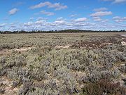
Vegetation
Myrtaceae
The Myrtaceae or Myrtle family are a family of dicotyledon plants, placed within the order Myrtales. Myrtle, clove, guava, feijoa, allspice, and eucalyptus belong here. All species are woody, with essential oils, and flower parts in multiples of four or five...
and proteaceous
Proteaceae
Proteaceae is a family of flowering plants distributed in the Southern Hemisphere. The family comprises about 80 genera with about 1600 species. Together with the Platanaceae and Nelumbonaceae they make up the order Proteales. Well known genera include Protea, Banksia, Embothrium, Grevillea,...
heath
Heath (habitat)
A heath or heathland is a dwarf-shrub habitat found on mainly low quality acidic soils, characterised by open, low growing woody vegetation, often dominated by plants of the Ericaceae. There are some clear differences between heath and moorland...
. Over 50% of the area is vegetated entirely by mallee, and a further 25% is mainly mallee but with patches of woodland; the latter vegetation occurs mainly on the calcareous soils to the east. The mallee consists of numerous Eucalyptus species, the most consistent being E. eremophila
Eucalyptus eremophila
Sand Mallee is a eucalypt native to semi-arid regions of Western Australia. The epithet eremophila means "desert-loving". It usually grows in a multi-stemmed mallee form, although single-stemmed individuals do occur. The bark is smooth and polished, shedding in late summer...
(Tall Sand Mallee). Seasonally wet and alluvial
Alluvium
Alluvium is loose, unconsolidated soil or sediments, eroded, deposited, and reshaped by water in some form in a non-marine setting. Alluvium is typically made up of a variety of materials, including fine particles of silt and clay and larger particles of sand and gravel...
areas are vegetated by Melaleuca
Melaleuca
Melaleuca is a genus of plants in the myrtle family Myrtaceae known for its natural soothing and cleansing properties. There are well over 200 recognised species, most of which are endemic to Australia...
shrublands where fresh
Fresh Water
Fresh Water is the debut album by Australian rock and blues singer Alison McCallum, released in 1972. Rare for an Australian artist at the time, it came in a gatefold sleeve...
, and Tecticornia low shrublands where saline
Salinity in Australia
Soil salinity and dryland salinity are two problems degrading the environment of Australia. Salinity is a concern in most states, but especially in the south-west of Western Australia....
. There are also occasional thickets of Allocasuarina
Allocasuarina
Allocasuarina is a genus of trees in the flowering plant family Casuarinaceae. They are endemic to Australia, occurring primarily in the south. Like the closely related genus Casuarina, they are commonly called sheoaks or she-oaks, they are notable for their long, segmented branchlets that...
, especially on greenstone
Greenstone belt
Greenstone belts are zones of variably metamorphosed mafic to ultramafic volcanic sequences with associated sedimentary rocks that occur within Archaean and Proterozoic cratons between granite and gneiss bodies....
hills.
As of 2007, the Mallee region is known to contain 3443 indigenous vascular plant species, and a further 239 naturalised alien species. As with other regions in semi-arid areas of the South West, it exhibits high endemism
Endemic (ecology)
Endemism is the ecological state of being unique to a defined geographic location, such as an island, nation or other defined zone, or habitat type; organisms that are indigenous to a place are not endemic to it if they are also found elsewhere. For example, all species of lemur are endemic to the...
, especially with respect to Eucalyptus and Acacia
Acacia
Acacia is a genus of shrubs and trees belonging to the subfamily Mimosoideae of the family Fabaceae, first described in Africa by the Swedish botanist Carl Linnaeus in 1773. Many non-Australian species tend to be thorny, whereas the majority of Australian acacias are not...
species. The endangered flora of the Mallee region consists of 55 species, with a further 325 species having been declared Priority Flora under the Department of Environment and Conservation's Declared Rare and Priority Flora List.
Species richness ranges from 17 to 48 species per 1000 m². The lowest species richness occurs in severe habitats such as alongside salt lakes, but also in the areas of highest soil nutrition, where dominant species suppress associated species. Conversely, the highest species richness occurs in soils with the lowest soil nutrition. Most species are killed by fire and regenerate from seed, suggesting that they have evolved in an environment in which fire is infrequent.
| Major Vegetation Group | Area before European settlement | Area circa 1997 |
|---|---|---|
| Cleared / modified native vegetation | - | 3,389,464 ha (45.8%) |
| Mallee woodlands and shrublands Mallee Woodlands and Shrublands Mallee Woodlands and Shrublands is a Major Vegetation Group which occurs in semi-arid areas of southern Australia. The vegetation is dominated by mallee eucalypts which are rarely over 6 metres high... |
4,208,658 ha (56.9%) | 2,152,520 (29.1%) |
| Eucalyptus open woodlands | 1,860,688 ha (25.2%) | 896,404 (12.1%) |
| Eucalpt woodlands | 587,132 ha (7.9%) | 587,132 (7.9%) |
| Heath | 432,536 ha (5.8%) | 196,164 ha (2.7%) |
| Mangroves, tidal mudflat, samphire and bare areas, claypan, sand, rock, salt lakes, lagoons, lakes | 212,504 ha (2.9%) | 105,308 ha (1.4%) |
| Other shrublands | 58,628 ha (0.8%) | 53,316 ha (0.7%) |
| Chenopod shrub, samphire shrub and forblands | 22,652 ha (0.3%) | 5,516 ha (0.1%) |
| Eucalypt low open forest | 6,100 ha (0.1%) | 4,492 ha (0.1%) |
| Low closed forest and closed shrublands | 2,912 ha (0.0%) | 2,668 ha (0.0%) |
| Acacia shrublands | 1,352 ha (0.0%) | 1,348 ha (0.0%) |
| Other grasslands, herblands, sedgelands and rushlands | 820 ha (0.0%) | 364 ha (0.0%) |
| Casuarina forest and woodlands | 612 ha (0.0%) | 116 ha (0.0%) |
| Tussock grasslands | 28 ha (0.0%) | 4 ha (0.0%) |
| Melaleuca forest and woodlands | 12 ha (0.0%) | 4 ha (0.0%) |
Land use
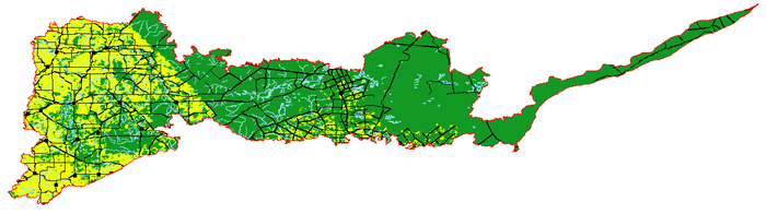
Approximately 56% of the Mallee region falls within what the Department of Agriculture and Food calls the "Intensive Land-use Zone" (ILZ), the area of Western Australia that has been largely cleared and developed for intensive agriculture such as cropping and livestock production. This includes most of the western parts of the region, and a smaller area along the road from Norseman to Esperance. Within this area, only 19.5% of the native vegetation remains uncleared. The remaining 44% of the region falls within the "Extensive Land-use Zone" (ELZ), where the native vegetation has not been cleared but may have been degraded by the grazing of introduced animals and/or changes to the fire regime. Thus about 44.9% of the total Mallee region has been cleared. The majority of clearing was undertaken by the Government of Western AustraliaGovernment of Western Australia
The formation of the Government of Western Australia is prescribed in its Constitution, which dates from 1890, although it has been amended many times since then...
between 1958 and 1969, under a program of assisted settlement in which the Government cleared, fenced and stocked virgin crown land
Crown land
In Commonwealth realms, Crown land is an area belonging to the monarch , the equivalent of an entailed estate that passed with the monarchy and could not be alienated from it....
, then sold it to aspiring settlers. There has been virtually no further clearing since 1980, when Beard estimated the cleared proportion of the region at 44%.
About 30% of the Esperance Plains region is now in protected areas
Protected areas of Western Australia
Western Australia is the second largest subnational entity in the world. It contains no fewer than 1224 separate Protected Areas with a total area of 170,610 km²...
. It therefore has only medium priority under Australia's National Reserve System.
Biogeography
Early biogeographic regionalisations of Western Australia do not recognise the Mallee region. It cannot be distinguished in Ludwig DielsLudwig Diels
Dr. Friedrich Ludwig Emil Diels , was a German botanist.Diels was born in Hamburg, the son of the classical scholar Hermann Alexander Diels. From 1900 to 1902 he traveled together with Ernst Pritzel through South Africa, Java, Australia and New Zealand. Shortly before the first world war he...
' 1906 regionalisation of the South West, and is treated as part of the Wheatbelt in Edward de Courcy Clarke
Edward de Courcy Clarke
Professor Edward de Courcy Clarke , was a teacher, researcher and field geologist, winner of the Clarke Medal in 1954.- Biography :Clarke was born in Waimate, New Zealand, and studied at the University of Auckland, graduating in 1901....
's 1926 map. It first appeared in Beard's 1980 phytogeographic
Phytogeography
Phytogeography , also called geobotany, is the branch of biogeography that is concerned with the geographic distribution of plant species...
regionalisation of Western Australia, but with an eastern limit of Point Culver
Point Culver
Point Culver is a headland on the south coast of Western Australia. It is located at 32° 54' S 124° 41' E, near the western end of the Great Australian Bight....
. Beard named it "Roe Botanical District" in honour of John Septimus Roe
John Septimus Roe
John Septimus Roe was the first Surveyor-General of Western Australia. He was a renowned explorer, and a Member of Western Australia's Legislative and Executive Councils for nearly 40 years.-Early life:...
, who explored the area in 1848. By 1984, Beard's phytogeographic regions were being presented more generally as "natural regions", and as such were given more widely recognisable names. Thus the "Roe Botanical District" became "Mallee".
When the IBRA was published in the 1990s, Beard's regionalisation was used as the baseline for Western Australia. The Mallee region was accepted as defined by Beard, and has since survived a number of revisions. The only significant change to its boundary is the extension of its eastern boundary eastwards along the coast as far as Eyre. The most recent revision, Version 6.1, defines two sub-regions for the Mallee region, Western Mallee
Western Mallee
Western Mallee is an Interim Biogeographic Regionalisation for Australia subregion in southern Western Australia. It is a sparsely populated subregion with an area of about 47,000 square kilometres, roughly centred on the town of Newdegate...
and Eastern Mallee
Eastern Mallee
Eastern Mallee is an Interim Biogeographic Regionalisation for Australia subregion in southern Western Australia.-Geography:Eastern Mallee is roughly defined as the eastern half of the Mallee biogeographic region. It has an area of around 46,000 square kilometres, and is very sparsely populated....
.
Under the World Wildlife Fund's biogeographic regionalisation of the Earth's land into "ecoregion
Ecoregion
An ecoregion , sometimes called a bioregion, is an ecologically and geographically defined area that is smaller than an ecozone and larger than an ecosystem. Ecoregions cover relatively large areas of land or water, and contain characteristic, geographically distinct assemblages of natural...
s", Mallee is combined with Esperance Plains to form the Esperance mallee
Esperance mallee
Esperance Mallee is a World Wide Fund for Nature ecoregion on the south coast of Western Australia, a coastal strip where the predominant vegetation consists of short eucalyptus trees and shrubs.-Location and description:...
ecoregion.
Further reading
- Thackway, R and I D Cresswell (1995) An interim biogeographic regionalisation for Australia : a framework for setting priorities in the National Reserves System Cooperative Program Version 4.0 Canberra : Australian Nature Conservation Agency, Reserve Systems Unit, 1995. ISBN 0642213712