

Little Sandy Desert
Encyclopedia
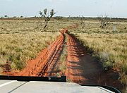

Desert
A desert is a landscape or region that receives an extremely low amount of precipitation, less than enough to support growth of most plants. Most deserts have an average annual precipitation of less than...
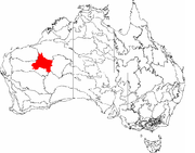
located in Western Australia
Western Australia
Western Australia is a state of Australia, occupying the entire western third of the Australian continent. It is bounded by the Indian Ocean to the north and west, the Great Australian Bight and Indian Ocean to the south, the Northern Territory to the north-east and South Australia to the south-east...
south of the Great Sandy Desert
Great Sandy Desert
The Great Sandy Desert is a desert located in the North West of Western Australia straddling the Pilbara and southern Kimberley regions. It is the second largest desert in Australia after the Great Victoria Desert and encompasses an area of...
and west of the Gibson Desert
Gibson Desert
The Gibson Desert covers a large dry area in the state of Western Australia and is still largely in an almost "pristine" state. It is about in size, making it the 5th largest desert in Australia, after the Great Sandy, Great Victoria, Tanami and Simpson deserts.-Location and description:The Gibson...
. It is to the east of Great Northern Highway
Great Northern Highway
The Great Northern Highway is a generally north-south Western Australian highway which links the state's capital Perth with its most northern port, Wyndham. It is in length, with being National Highway...
south of Newman
Newman, Western Australia
Newman, located about 1186 km north of Perth and 9 km north of the Tropic of Capricorn, is a town in the Pilbara region. It can be reached by the Great Northern Highway...
and approximately 200 kilometres north of Wiluna
Wiluna, Western Australia
Wiluna is a complex town in the Mid West region of Western Australia. It is situated on the edge of the Western Desert at the gateway to the Canning Stock Route and Gunbarrel Highway. It is the service centre of the local area for the local Aboriginal people, the pastoral industry, mining, and...
. To the north the nearest large area identifiable is the Karlamilyi National Park.
It is named because it is relatively close and similar to the Great Sandy Desert, but is much smaller. Its landforms, fauna and flora, etc., are all similar to the Great Sandy Desert. Both deserts are crossed by the Canning Stock Route
Canning Stock Route
The Canning Stock Route is one of the toughest and most remote tracks in the world. It runs to Halls Creek from Wiluna, both in Western Australia. With a total distance of around it is also the longest historic stock route in the world...
.
It is one of Western Australia's Interim Biogeographic Regionalisation for Australia
Interim Biogeographic Regionalisation for Australia
The Interim Biogeographic Regionalisation for Australia is a biogeographic regionalisation of Australia developed by the Australian Government's Department of the Environment, Water, Heritage and the Arts...
(IBRA) regions.
Indigenous groups that have identified with the region include the Mandildjara
Further reading
- Thackway, R and I D Cresswell (1995) An interim biogeographic regionalisation for Australia : a framework for setting priorities in the National Reserves System Cooperative Program Version 4.0 Canberra : Australian Nature Conservation Agency, Reserve Systems Unit, 1995. ISBN 0642213712