

Regions of Western Australia
Encyclopedia
Regionalisations of Western Australia are systems by which Western Australia
is divided into distinct geographic regions. The most commonly known regionalisation is the governmental division of the state into regions for economic development purposes, of which there are nine.
Other regionalisations include those made for purposes of land management, such as agriculture or conservation; and information gathering, such as statistical or meteorological.
Although most regionalisations were defined for specific purposes and give specific boundaries, many regions will have similar names and extents across different regionalisations. As a result, the names and boundaries of regions can vary in popular usage.
 The most widely known regionalisation of Western Australia is the one defined by the State
Government
for purposes of economic development administration. Together, these constitute the whole of mainland Western Australia, with the exception of the Perth
metropolitan area which is not contained in a region.
These regions were established by the Regional Development Commissions Act 1993
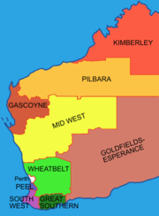
, which defined their extents and established Regional Development Commissions to promote their economic development. In defining the regions, an attempt was made to capture distinct socio-economic communities. For example, the Goldfields-Esperance region of Western Australia has an economy based heavily on mining, whereas the Wheatbelt region is economically dependent on agriculture.
The regions as determined are:
For the earlier land administrative divisions of Western Australia - see: - Lands administrative divisions of Western Australia#Land divisions
The BOM designates the forecast areas with finer detail on weather reports into points of the compass - as with the Interior area - southern interior, and western interior.
Numbers 7 to 13 are usually known as those forecast areas in the Southwest Land Division, and coastal zones for sea forecasts are dealt with in Coastal regions of Western Australia
Federal government
State government
Local government
Department of Education
Department of Agriculture and Food
Main Roads Western Australia
Department of Water
Department of Fisheries
Fisheries tends to separate the state into four main regions for the purpose of regulating recreational fishing:
Department of Mines and Petroleum
The Department produces statistical data based on the Regional Development Commissions Act regionalisation schema
Since the creation of the Department of Industry and Resources some rationalisation of mines administration has occurred, however the mineral fields and boundaries remain the same as when established.
(IBRA) regions, and the World Wildlife Fund's Ecoregions in Australia
, and the "natural regions" of John Stanley Beard
, all of which are based on biogeography
. Other natural regionalisations included the drainage basins and catchments of river systems, and highly specialised regionalisations dealing with such matters as geology and soil systems.
Administrative regionalisations include Landcare Districts and the Department of Agriculture's "Land-use Zones". However the Department of Agriculture publications - Technical Bulletins - usually titled An inventory and condition report/survey... of a particular region are very specifically focused upon land systems
that are based on natural features.
s legislation as determined by the Australian Wine and Brandy Corporation
.
Wine regions include:
Western Australia has the longest coastline of any state in Australia, at 10,194 km. The regions can be determined by the underlying geology, and in the case of the Bureau of Meteorology - features such as points and capes are useful indicators of coastal water forecasts.
Landgate
publishes touring maps that include coastal zones including:
, the Australian Bureau of Statistics
uses the Australian Standard Geographical Classification, a hierarchical regionalisation that divides Western Australia into statistical divisions, then statistical subdivisions, statistical local areas, and finally, census collection districts.
Statistical Divisions include:
The ABS produces Regional profiles for the nine ABS Statistical Divisions, and the ten Development Commission regions.
Western Australia
Western Australia is a state of Australia, occupying the entire western third of the Australian continent. It is bounded by the Indian Ocean to the north and west, the Great Australian Bight and Indian Ocean to the south, the Northern Territory to the north-east and South Australia to the south-east...
is divided into distinct geographic regions. The most commonly known regionalisation is the governmental division of the state into regions for economic development purposes, of which there are nine.
Other regionalisations include those made for purposes of land management, such as agriculture or conservation; and information gathering, such as statistical or meteorological.
Although most regionalisations were defined for specific purposes and give specific boundaries, many regions will have similar names and extents across different regionalisations. As a result, the names and boundaries of regions can vary in popular usage.
The Regional Development Commissions Act regionalisation
States and territories of Australia
The Commonwealth of Australia is a union of six states and various territories. The Australian mainland is made up of five states and three territories, with the sixth state of Tasmania being made up of islands. In addition there are six island territories, known as external territories, and a...
Government
Government of Western Australia
The formation of the Government of Western Australia is prescribed in its Constitution, which dates from 1890, although it has been amended many times since then...
for purposes of economic development administration. Together, these constitute the whole of mainland Western Australia, with the exception of the Perth
Perth, Western Australia
Perth is the capital and largest city of the Australian state of Western Australia and the fourth most populous city in Australia. The Perth metropolitan area has an estimated population of almost 1,700,000....
metropolitan area which is not contained in a region.
These regions were established by the Regional Development Commissions Act 1993
Regional Development Commissions Act 1993
The Regional Development Commissions Act 1993 is legislation passed by the Parliament of Western Australia:to establish regional development commissions, to coordinate and promote the development of regions and to establish a regional development council.The Act falls under the control of the...
, which defined their extents and established Regional Development Commissions to promote their economic development. In defining the regions, an attempt was made to capture distinct socio-economic communities. For example, the Goldfields-Esperance region of Western Australia has an economy based heavily on mining, whereas the Wheatbelt region is economically dependent on agriculture.
The regions as determined are:
- Gascoyne
- Goldfields-Esperance
- Great Southern
- Kimberley
- Mid West
- Peel
- Pilbara
- South West
- Wheatbelt
For the earlier land administrative divisions of Western Australia - see: - Lands administrative divisions of Western Australia#Land divisions
Bureau of Meteorology areas
The same terms used by the RDCA are also used by BOM - but do not directly coincide with the boundaries of the Regional Development defined boundaries above.The BOM designates the forecast areas with finer detail on weather reports into points of the compass - as with the Interior area - southern interior, and western interior.
Numbers 7 to 13 are usually known as those forecast areas in the Southwest Land Division, and coastal zones for sea forecasts are dealt with in Coastal regions of Western Australia
Coastal regions of Western Australia
Western Australia has the longest coastline of any state in Australia, at 10,194 km or 12,889 km.-Integrated Marine and Coastal Regionalisation of Australia:...
| BOM Map number | BOM name | RDCA name | BOM overlap areas | RDCA overlap areas | notes |
|---|---|---|---|---|---|
| 01 | Kimberley | Kimberley | South East Kimberley in BOM 'NE Interior' | close fit | |
| 02 | Pilbara | Pilbara | BOM North Interior in RDCA 'East Pilbara' | ||
| 03 | Gascoyne | Gascoyne | BOM South and East Gascoyne in RDCA 'Mid West' | ||
| 04 | Goldfields | Goldfields-Esperance | |||
| 05 | Eucla | Goldfields-Esperance | |||
| 06 | Interior | Goldfields-Esperance, Mid West, Pilbara | |||
| 07 | Central West | Mid West | |||
| 08 | Lower West | Perth, Peel | |||
| 09 | Southwest | South West | |||
| 10 | South Coastal | Great Southern | |||
| 11 | Southeast Coastal | Goldfields-Esperance | |||
| 12 | Great Southern | Great Southern | |||
| 13 | Central Wheat Belt | Wheatbelt | |||
Political regionalisations
Under Australia's three-tiered system of government, Western Australia has three political regionalisation schemes:Federal government
- Divisions of the Australian House of Representatives for election to the Australian House of RepresentativesAustralian House of RepresentativesThe House of Representatives is one of the two houses of the Parliament of Australia; it is the lower house; the upper house is the Senate. Members of Parliament serve for terms of approximately three years....
State government
- Electoral DistrictsElectoral districts of Western AustraliaThe Western Australian Legislative Assembly is elected from 59 single-member electoral districts. These districts are often referred to as electorates or seats....
for election to the Western Australian Legislative AssemblyWestern Australian Legislative AssemblyThe Legislative Assembly, or lower house, is one of the two chambers of parliament in the Australian state of Western Australia. It sits in Parliament House in the state capital, Perth.... - Electoral RegionsElectoral regions of Western AustraliaThe Western Australian Legislative Council is elected from six multi-member electoral regions, which are in turn composed of electoral districts which are used to elect the Legislative Assembly. The current number of electoral regions was established in 1989 under the Acts Amendment Act 1987,...
for election to the Western Australian Legislative CouncilWestern Australian Legislative CouncilThe Legislative Council, or upper house, is one of the two chambers of parliament in the Australian state of Western Australia. Its central purpose is to act as a house of review for legislation passed through the lower house, the Legislative Assembly. It sits in Parliament House in the state...
Local government
State government departmental regionalisations
Many government departments maintain systems of regional and district breakdowns of the state for their own internal purposes.Department of Education
- Goldfields
- Kimberley
- Midwest
- North Metro
- Pilbara
- South Metro
- Southwest
- Wheatbelt
Department of Agriculture and Food
- Northern Agricultural Region
- Rangelands Region
- Southern Agricultural Region
- Central Agricultural Region
- South West Agricultural
Main Roads Western Australia
Main Roads Western Australia
Main Roads Western Australia is an agency of the Government of Western Australia that is responsible for implementing the state's policies on road access and main roads. It operates under the Main Roads Act 1930 ....
- Kimberley
- Pilbara
- Gascoyne
- Mid-West
- Goldfields-Esperance
- Wheatbelt North
- Metropolitan
- Wheatbelt South
- Great Southern
- South-West
Department of Water
Department of Water (Western Australia)
The Department of Water is the department of the Government of Western Australia that is responsible for management of Western Australia's water resources....
- Kimberley
- Pilbara
- Mid West Gascoyne
- Goldfields
- Swan-Avon
- Kwinana Peel
- South West
- South Coast
Department of Fisheries
Fisheries tends to separate the state into four main regions for the purpose of regulating recreational fishing:
- Pilbara-Kimberley
- Gascoyne
- WestCoast
- South Coast.
Department of Mines and Petroleum
Department of Mines and Petroleum
The Department of Mines and Petroleum is a department of the Government of Western Australia. The department was formed on 1 January 2009, out of the former Department of Industry and Resources and Department of Consumer and Employment Protection, which were split into three new departments, the...
The Department produces statistical data based on the Regional Development Commissions Act regionalisation schema
Since the creation of the Department of Industry and Resources some rationalisation of mines administration has occurred, however the mineral fields and boundaries remain the same as when established.
Natural and land management
There are a number of regionalisations that purport or attempt to provide a regionalisation based on natural features. The best known of these are the Interim Biogeographic Regionalisation for AustraliaInterim Biogeographic Regionalisation for Australia
The Interim Biogeographic Regionalisation for Australia is a biogeographic regionalisation of Australia developed by the Australian Government's Department of the Environment, Water, Heritage and the Arts...
(IBRA) regions, and the World Wildlife Fund's Ecoregions in Australia
Ecoregions in Australia
Ecoregions in Australia are geographically distinct plant and animal communities, defined by the World Wide Fund for Nature based on geology, soils, climate, and predominant vegetation....
, and the "natural regions" of John Stanley Beard
John Stanley Beard
John Stanley Beard was a British-born forester and ecologist who resided in Australia. While working with the Forestry Division in Trinidad and Tobago during the 1940s, Beard developed a system of forest classification for Tropical America and described the forests of Trinidad, Tobago, and the...
, all of which are based on biogeography
Biogeography
Biogeography is the study of the distribution of species , organisms, and ecosystems in space and through geological time. Organisms and biological communities vary in a highly regular fashion along geographic gradients of latitude, elevation, isolation and habitat area...
. Other natural regionalisations included the drainage basins and catchments of river systems, and highly specialised regionalisations dealing with such matters as geology and soil systems.
Administrative regionalisations include Landcare Districts and the Department of Agriculture's "Land-use Zones". However the Department of Agriculture publications - Technical Bulletins - usually titled An inventory and condition report/survey... of a particular region are very specifically focused upon land systems
Land systems of Western Australia
Land systems of Western Australia are descriptions of the Western Australian landscape which takes into account the landform, the soils, the vegetation, and site types The Lands systems can be seen as sub-components of the IBRA system....
that are based on natural features.
Land tenure
Western Australia is divided into approximately 90 land districts for cadastral purposes. There are five land divisions in Western Australia, as specified in Schedule 1 of the Land Administration Act 1997.- Eastern Land Division
- Eucla Land Division
- Kimberley Land Division
- North-West Land Division
- South-West Land Division
Wine regions
Australia’s biggest State extends the western third of the continent, although the winemaking regions are almost entirely situated in the south-western tip of the State. It has nine regions, and five nominated subregions for wine under the Geographical indicationGeographical indication
A geographical indication is a name or sign used on certain products which corresponds to a specific geographical location or origin...
s legislation as determined by the Australian Wine and Brandy Corporation
Australian Wine and Brandy Corporation
Wine Australia , is an Australian Government authority that promotes and regulates the Australian wine industry. It was created in 1981 to replace the Australian Wine Board after the Australian Wine and Brandy Corporation Act 1980, now the Wine Australia Corporation Act 1980 was passed...
.
Wine regions include:
- Greater Perth
- Perth Hills
- Peel
- Swan DistrictSwan Valley, Western AustraliaThe Swan Valley is a region in the upper reaches of the Swan River between Guildford and Bells Rapids, Western Australia. It is bordered to the east by the Darling Scarp. Both Ellen Brook and Jane Brook lie within the region and discharge into the Swan River...
- South Western Australia
- Blackwood ValleyBlackwood ValleyBlackwood Valley is a region in the south-west of Western Australia, approximately 260 km south-south-east of Perth. The region was named after the Blackwood River, the longest continually flowing river in Western Australia...
- Geographe
- Great SouthernGreat Southern Wine RegionThe Great Southern Wine Region in Western Australia's South West is Australia's largest wine region a rectangle 200 kilometres from east to west and over 100 kilometers from north to south...
- Albany
- Denmark
- Frankland River
- Mount Barker
- Porongurup
- ManjimupManjimup, Western AustraliaManjimup is a town in Western Australia, south of the state capital, Perth. The town of Manjimup is a regional centre for the largest shire in the South West of Western Australia. At the 2006 census, Manjimup had a population of 4,239.-History:...
- Margaret RiverMargaret River (wine region)Margaret River is the foremost Geographical Indication wine region in the South West Australia Zone, with nearly 5,500 hectares under vine and over 138 wineries as at 2008. Margaret River wine region is made up predominately of boutique size wine producers; although winery operations range from the...
- PembertonPemberton, Western AustraliaPemberton is a town located in the South West region of Western Australia, named after the early settler Pemberton Walcott. It is the home of the karri tree, the largest tree in Western Australia and the third largest hardwood tree in the world...
- Blackwood Valley
Coastal regions
Western Australia has the longest coastline of any state in Australia, at 10,194 km. The regions can be determined by the underlying geology, and in the case of the Bureau of Meteorology - features such as points and capes are useful indicators of coastal water forecasts.
Landgate
Landgate
Landgate, formerly the Department of Land Information , the Department of Land Administration and the Department of Lands and Surveys is the statutory authority responsible for Western Australia's property and land information.-Current activities:Landgate maintains the official register of land...
publishes touring maps that include coastal zones including:
- Batavia Coast (incorporating the area of Cervantes, Jurien Bay, Dongara, Geraldton, and Kalbarri)
- Gascoyne Coast (Carnarvon, Coral Bay, Denham, Exmouth and the Coral Coast)
- Coral Coast (at the northern end of the Gascoyne Coast)
- Sunset CoastSunset CoastSunset Coast is the name given by the Tourism Western Australia to the coastal section of the northern metropolitan area of Perth, the capital city of Western Australia, and is one of the six component tourism precincts of the Perth region...
(Perth Metropolitan beachside suburbs from Cottesloe to Yanchep)
Census and Australian Bureau of Statistics
For the purposes of statistical geographyStatistical geography
Statistical geography is the study and practice of collecting, analysing and presenting data that has a geographic or areal dimension, such as census or demographics data. It uses techniques from spatial analysis, but also encompasses geographical activities such as the defining and naming of...
, the Australian Bureau of Statistics
Australian Bureau of Statistics
The Australian Bureau of Statistics is Australia's national statistical agency. It was created as the Commonwealth Bureau of Census and Statistics on 8 December 1905, when the Census and Statistics Act 1905 was given Royal assent. It had its beginnings in section 51 of the Constitution of Australia...
uses the Australian Standard Geographical Classification, a hierarchical regionalisation that divides Western Australia into statistical divisions, then statistical subdivisions, statistical local areas, and finally, census collection districts.
Statistical Divisions include:
- SD 505 - Perth
- SD 510 - South West
- SD 515 - Lower Great Southern
- SD 520 - Upper Great Southern
- SD 525 - Midlands
- SD 530 - South Eastern
- SD 535 - Central
- SD 540 - Pilbara
- SD 545 - Kimberley
The ABS produces Regional profiles for the nine ABS Statistical Divisions, and the ten Development Commission regions.
See also
- List of regions of Australia
- Geography of Western AustraliaGeography of Western AustraliaWestern Australia occupies nearly one third of the Australian continent. Due to the size and the isolation of the state, considerable emphasis has been made of these features; it is the second largest administrative territory in the world, after Yakutia in Russia, and no other regional...
- Australian Regional RivalriesAustralian regional rivalriesAustralian regional rivalries refers to the rivalries between Australian cities or regions.-Sydney - Melbourne rivalry:There has been a long standing rivalry between the cities of Sydney and Melbourne, the two largest cities in Australia...
External links
Further reading
- Regions Western Australia. Perth, W.A. : Dept. of Commerce and Trade. Issue 1 (Mar./June 1998)-issue 11 (February 2002)
- Regional futures: challenges and opportunities for Western Australia's regions: a discussion paper prepared by the Regional Development Council and the Department of Commerce and Trade. Perth, W.A. : The Council, Rev. June 1996.
- Western Australia: a statistical snapshot of the regions prepared by the Department of Commerce and Trade for the Regional Development Council. Perth: The Department., 1995.
- Western Australia tomorrow: population projections for the statistical divisions, planning regions and local government areas of Western Australia. Perth, W.A. : Western Australian Planning Commission, 2000. Population report (Western Australian Planning Commission) ; no. 4. ISBN 0730992225
Maps
- Streetsmart Travellers Atlas of Western Australia (2006) Department of Land Information and West Australian Newspapers,9th ed. ISBN 1-921048-13-1
- Quality Publishing Australia.(2007) Roads & tracks Western Australia: campsites directory, roads and tracks, all in one Jolimont, W.A.,Quality Publishing Australia, 5th ed ISBN 1876723351
- UBD Western Australia country road atlas (2005) Macquarie Park, N.S.W.UBD, a division of Universal Publishers, 11th ed ISBN 0-7319-1587-9