

Great Victoria Desert
Encyclopedia
Desert
A desert is a landscape or region that receives an extremely low amount of precipitation, less than enough to support growth of most plants. Most deserts have an average annual precipitation of less than...
area of southern Australia.
Location and description
The Great Victoria is the biggest desert in Australia and consists of many small sandhills, grasslandGrassland
Grasslands are areas where the vegetation is dominated by grasses and other herbaceous plants . However, sedge and rush families can also be found. Grasslands occur naturally on all continents except Antarctica...
plains, areas with a closely packed surface of pebbles (called desert pavement
Desert pavement
A desert pavement is a desert surface that is covered with closely packed, interlocking angular or rounded rock fragments of pebble and cobble size.-Formation:Several theories have been proposed for their formation...
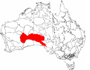
or gibber plains) and salt lakes. It is over 700 kilometres (435 mi) wide (from west to east) and covers an area of 424400 square kilometres (163,861.8 sq mi) from the Eastern Goldfields
Eastern Goldfields
The Eastern Goldfields is a figurative area used in speech to describe a region of Western Australia.-Name:The name is derived in two parts from, Eastern in relation to its location from Perth and Goldfields as the name suggests comes from the mining of Gold in the region...
region of Western Australia to the Gawler Ranges
Gawler Ranges
The Gawler Ranges are a range of stoney hills in South Australia to the north of Eyre Peninsula. The Eyre Highway skirts the south of the ranges. The Gawler Ranges National Park and Gawler Ranges Conservation Reserve are in the ranges north of Wudinna...
in South Australia
South Australia
South Australia is a state of Australia in the southern central part of the country. It covers some of the most arid parts of the continent; with a total land area of , it is the fourth largest of Australia's six states and two territories.South Australia shares borders with all of the mainland...
. The Western Australia Mallee shrub
Mallee Woodlands and Shrublands
Mallee Woodlands and Shrublands is a Major Vegetation Group which occurs in semi-arid areas of southern Australia. The vegetation is dominated by mallee eucalypts which are rarely over 6 metres high...
ecoregion lies to the west, the Little Sandy Desert
Little Sandy Desert
The Little Sandy Desert is a desert located in Western Australia south of the Great Sandy Desert and west of the Gibson Desert. It is to the east of Great Northern Highway south of Newman and approximately 200 kilometres north of Wiluna...
to the northwest, the Gibson Desert
Gibson Desert
The Gibson Desert covers a large dry area in the state of Western Australia and is still largely in an almost "pristine" state. It is about in size, making it the 5th largest desert in Australia, after the Great Sandy, Great Victoria, Tanami and Simpson deserts.-Location and description:The Gibson...
and the Central Ranges xeric shrublands to the north, the Tirari
Tirari Desert
The Tirari Desert is a desert in the eastern part of the Far North region of South Australia.-Location and description:The Tirari Desert features salt lakes and large north-south running sand dunes....
and Sturt Stony deserts to the east, while the Nullarbor Plain
Nullarbor Plain
The Nullarbor Plain is part of the area of flat, almost treeless, arid or semi-arid country of southern Australia, located on the Great Australian Bight coast with the Great Victoria Desert to its north. It is the world's largest single piece of limestone, and occupies an area of about...
to the south separates it from the Southern Ocean
Southern Ocean
The Southern Ocean comprises the southernmost waters of the World Ocean, generally taken to be south of 60°S latitude and encircling Antarctica. It is usually regarded as the fourth-largest of the five principal oceanic divisions...
. Average annual rain
Rain
Rain is liquid precipitation, as opposed to non-liquid kinds of precipitation such as snow, hail and sleet. Rain requires the presence of a thick layer of the atmosphere to have temperatures above the melting point of water near and above the Earth's surface...
fall is low and irregular, ranging from 200 to 250 mm (7.9 to 9.8 in) per year. Thunderstorms are relatively common in the Great Victoria Desert, with an average of 15–20 thunderstorms per annum. Summer daytime temperatures range from 32 to 40 °C (89.6 to 104 F) while in winter, this falls to 18 to 23 °C (64.4 to 73.4 F).
Habitation
In much of the region, the majority of people living in the area are Indigenous AustraliansIndigenous Australians
Indigenous Australians are the original inhabitants of the Australian continent and nearby islands. The Aboriginal Indigenous Australians migrated from the Indian continent around 75,000 to 100,000 years ago....
. Young Indigenous adults from the Great Victoria Desert region work in the Wilurarra Creative programs to maintain and develop their culture.
Almost no farming activity is carried out in this arid desert which is mostly unpopulated. Human activity has included some mining and nuclear weapons testing while today the desert is inhabited by different groups of Indigenous Australians
Indigenous Australians
Indigenous Australians are the original inhabitants of the Australian continent and nearby islands. The Aboriginal Indigenous Australians migrated from the Indian continent around 75,000 to 100,000 years ago....
including the Kogara, the Mirning
Mirning
The Mirning people are a group of Indigenous Australians whose traditional lands lie in the coastal region of the Great Australian Bight in the south-west of South Australia and bordering Western Australia.-People and Culture:...
and the Pitjantjatjara. Despite its isolated location the Great Victoria is bisected by very rough tracks including the Connie Sue Highway
Connie Sue Highway
The Connie Sue Highway is an outback road that runs from Rawlinna on the Trans-Australian Railway to the Aboriginal community of Warburton on the Great Central Road. Approximately long and running north-south, it lies entirely in the state of Western Australia and crosses the Nullarbor Plain and...
and the Anne Beadell Highway
Anne Beadell Highway
The Anne Beadell Highway is an outback unsealed track linking Coober Pedy, South Australia, and Laverton, Western Australia. The track was surveyed and built by Len Beadell, Australian surveyor, who named it after his wife. -Overview:...
.
History
In 1875, British explorer Ernest GilesErnest Giles
William Ernest Powell Giles , best known as Ernest Giles, was an Australian explorer who led three major expeditions in central Australia.- Early life :...
became the first European to cross the desert. He named the desert after the then-reigning British monarch, Queen Victoria
Victoria of the United Kingdom
Victoria was the monarch of the United Kingdom of Great Britain and Ireland from 20 June 1837 until her death. From 1 May 1876, she used the additional title of Empress of India....
. In 1891, David Lindsey's expedition traveled across this area from north to south. Frank Hann
Frank Hann
Frank Hugh Hann was an explorer in Western Australia, who in 1897 named Lake Disappointment. Hann was in the area exploring the east Pilbara, around Rudall River. He noticed creeks in the area flowed inland, and followed them expecting to find a large fresh water lake...
was looking for gold in this area between 1903 and 1908. Len Beadell
Len Beadell
Leonard Beadell OAM BEM FIEMS was a surveyor, roadbuilder , bushman, artist and author, responsible for opening up the last remaining isolated desert areas of central Australia from 1947 to 1963. Len is sometimes called "the last true Australian explorer"...
explored the area in the 1960s.
Environment
The Great Victoria desert is a World Wildlife Fund ecoregionEcoregion
An ecoregion , sometimes called a bioregion, is an ecologically and geographically defined area that is smaller than an ecozone and larger than an ecosystem. Ecoregions cover relatively large areas of land or water, and contain characteristic, geographically distinct assemblages of natural...
and an Interim Biogeographic Regionalisation for Australia
Interim Biogeographic Regionalisation for Australia
The Interim Biogeographic Regionalisation for Australia is a biogeographic regionalisation of Australia developed by the Australian Government's Department of the Environment, Water, Heritage and the Arts...
(IBRA) region of the same name.
As this area has never been used for agriculture, habitats remain largely undisturbed while parts of the desert are protected areas including Mamungari Conservation Park (formerly known as Unnamed Conservation Park) in South Australia, a large area of pristine arid zone wilderness which possesses cultural significance and is one of the fourteen World Biosphere
Biosphere
The biosphere is the global sum of all ecosystems. It can also be called the zone of life on Earth, a closed and self-regulating system...
Reserves
Biosphere reserve
The Man and the Biosphere Programme of UNESCO was established in 1971 to promote interdisciplinary approaches to management, research and education in ecosystem conservation and sustainable use of natural resources.-Development:...
in Australia. Habitat is also preserved in the large Aboriginal
Indigenous Australians
Indigenous Australians are the original inhabitants of the Australian continent and nearby islands. The Aboriginal Indigenous Australians migrated from the Indian continent around 75,000 to 100,000 years ago....
local government area of Anangu Pitjantjatjara Yankunytjatjara
Anangu Pitjantjatjara Yankunytjatjara
Anangu Pitjantjatjara Yankunytjatjara is a large Aboriginal local government area located in the remote north west of South Australia...
in South Australia and in the Great Victoria Desert Nature Reserve of Western Australia.
The nuclear weapons trials carried out by the United Kingdom at Maralinga
Maralinga, South Australia
Maralinga, South Australia in the remote western areas of South Australia was the home of the Maralinga Tjarutja, a southern Pitjantjatjara Indigenous Australian people. Maralinga was the site of the secret British nuclear tests in the 1950s. The site measures about 3,300 km² in area...
and Emu Field
Emu Field
Emu Field is located in the desert of South Australia, at . Variously known as Emu Field, Emu Junction or Emu, it was the site of the Operation Totem pair of nuclear tests conducted by the British government in October 1953.The site was surveyed by Len Beadell in 1952...
in the 1950s and early 1960s have left areas contaminated with plutonium-239
Plutonium-239
Plutonium-239 is an isotope of plutonium. Plutonium-239 is the primary fissile isotope used for the production of nuclear weapons, although uranium-235 has also been used and is currently the secondary isotope. Plutonium-239 is also one of the three main isotopes demonstrated usable as fuel in...
and other radioactive material.
Flora
Only the hardiest of plants can survive in much of this environment. Between the sand ridges there are areas of wooded steppe consisting of Eucalyptus gongylocarpa, Eucalyptus youngianaEucalyptus youngiana
Eucalyptus youngiana, commonly known as Large-fruited Mallee, Ooldea Mallee and Yarldarlba, is a tree that occurs in arid and semi-arid areas of southern Western Australia and South Australia.-Description:...
and mulga (Acacia aneura) shrubs scattered over areas of resilient spinifex
Spinifex (genus)
Spinifex is a genus of perennial coastal grasses. They are one of the most common plants that grow in sand dunes along the coasts of Australia, New Zealand and New Caledonia.. As they help stabilise the sand, these grasses are an important part of the entire sand dune ecosystem. Of the four species...
grasses particularly Triodia basedowii.
Fauna
Wildlife adapted to these harsh conditions includes few large birds or mammals but the desert does sustain many types of lizard including the vulnerable great desert skinkGreat Desert Skink
The Great Desert Skink is a species of skink in the genus Egernia native to the western half of Australia . They are burrowing lizards and extremely social.- Description :...
(Egernia kintorei) and a number of small marsupials including the Sandhill Dunnart
Sandhill Dunnart
The Sandhill Dunnart is a species of small carnivorous Australian marsupial of the family Dasyuridae. It is known from four scattered arid areas of Australia: near Lake Amadeus in Northern Territory, the central Eyre Peninsula in South Australia, the southwestern edge of the Great Victoria Desert...
(Sminthopsis psammophila) and the vulnerable Crest-tailed Mulgara
Crest-tailed Mulgara
The Crest-tailed Mulgara also called the Ampurta is a species of carnivorous marsupial from Australia. Also called the Crest-tailed Marsupial Mouse, this animal slightly resembles a placental rat....
(Dasycercus cristicauda). One way to survive here is to burrow into the sands, as a number of the desert's animals, including the endangered Southern Marsupial Mole
Southern Marsupial Mole
The Southern Marsupial Mole is a mole-like marsupial found in the desert of southwest Australia. It is extremely adapted to a burrowing way of life. It has large, shovel-like forepaws and silky fur, which helps it move easily. The Southern Marsupial Mole also lacks complete eyes as it has little...
(notoryctes typhlops), and the Water-holding Frog do. Birds include the Chestnut-breasted Whiteface
Chestnut-breasted Whiteface
The Chestnut-breasted Whiteface is a species of bird in the Pardalotidae family.It is endemic to Australia and found primarily in northern South Australia.-Habitat:...
(Aphelocephala pectoralis) found on the eastern edge of the desert and the malleefowl
Malleefowl
The Malleefowl is a stocky ground-dwelling Australian bird about the size of a domestic chicken...
of Mamungari Conservation Park. Predators of the desert include the dingo
Dingo
The Australian Dingo or Warrigal is a free-roaming wild dog unique to the continent of Australia, mainly found in the outback. Its original ancestors are thought to have arrived with humans from southeast Asia thousands of years ago, when dogs were still relatively undomesticated and closer to...
(as the desert is north of the Dingo Fence
Dingo Fence
The Dingo Fence or Dog Fence is a pest-exclusion fence that was built in Australia during the 1880s and finished in 1885, to keep dingoes out of the relatively fertile south-east part of the continent and protect the sheep flocks of southern Queensland. It is one of the longest structures in the...
) and two large monitor lizards, the perentie
Perentie
The Perentie is the largest monitor lizard or goanna native to Australia, and fourth largest lizard on earth, after the Komodo Dragon, crocodile monitor and the water monitor...
(Varanus giganteus) and the sand goanna
Sand goanna
The Sand goanna is a large Australian monitor lizard - also known as Gould's monitor, the Sand monitor, or Racehorse goanna....
(Varanus gouldii).
External links
- http://www.diamantina-tour.com.au/outback_info/deserts/great_victoria/great_victoria_index.html; Online natural history of Great Victoria Desert
- http://westprint.com.au; Maps of Great Victoria Desert
See also
- Nullarbor PlainNullarbor PlainThe Nullarbor Plain is part of the area of flat, almost treeless, arid or semi-arid country of southern Australia, located on the Great Australian Bight coast with the Great Victoria Desert to its north. It is the world's largest single piece of limestone, and occupies an area of about...