
Interim Biogeographic Regionalisation for Australia
Encyclopedia
The Interim Biogeographic Regionalisation for Australia (IBRA) is a biogeographic
regionalisation of Australia developed by the Australian Government's Department of the Environment, Water, Heritage and the Arts. It was developed for use as a planning tool, for example for the establishment of a National Reserve System.

Biogeography
Biogeography is the study of the distribution of species , organisms, and ecosystems in space and through geological time. Organisms and biological communities vary in a highly regular fashion along geographic gradients of latitude, elevation, isolation and habitat area...
regionalisation of Australia developed by the Australian Government's Department of the Environment, Water, Heritage and the Arts. It was developed for use as a planning tool, for example for the establishment of a National Reserve System.
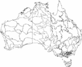
IBRA Version 6.1 regions and subregions
This is a list of region and subregions under IBRA Version 6.1. Region codes are given in parentheses.- Australian AlpsAustralian AlpsThe Australian Alps are the highest mountain ranges of mainland Australia. They are located in southeastern Australia and straddle the Australian Capital Territory, south-eastern New South Wales and eastern Victoria...
(AA)- Australian AlpsAustralian AlpsThe Australian Alps are the highest mountain ranges of mainland Australia. They are located in southeastern Australia and straddle the Australian Capital Territory, south-eastern New South Wales and eastern Victoria...
(AA1) - Victorian Alps (AA2)
- Australian Alps
- Arnhem Coast (ARC)
- Arnhem Coast P1 (ARC1)
- Arnhem Coast P2 (ARC2)
- Arnhem Coast P3 (ARC3)
- Arnhem Coast P4 Groote (ARC4)
- Arnhem Coast P5 Wessels (ARC5)
- Arnhem Plateau (ARP)
- Arnhem Plateau P1 (ARP1)
- Arnhem Plateau P2 (ARP2)
- Avon WheatbeltAvon WheatbeltAvon Wheatbelt is an Interim Biogeographic Regionalisation for Australia region in Western Australia and part of the larger Southwest Australia savanna ecoregion.-Further reading:...
(AW)- Avon Wheatbelt P1 (AW1)
- Avon Wheatbelt P2 (AW2)
- Brigalow Belt NorthBrigalow Belt NorthThe Brigalow Belt is a wide band of acacia wooded grassland that runs between tropical rainforest of the coast and the semi-desert interior of Queensland, Australia. The Northern and Southern Brigalow Belts are two of the 85 bioregions across Australia and the 15 bioregions in Queensland...
(BBN)- Townsville Plains (BBN1)
- Bogie River HillsBogie River HillsThe Bogie River Hills is a subregion of the Brigalow Belt North.The Bogie river Hills subregion has a total area of approximately 9000 sq kilometres and is oriented along a north-west - south-east axis...
(BBN2) - Cape River Hills (BBN3)
- Beucazon Hills (BBN4)
- Wyarra Hills (BBN5)
- Northern Bowen Basin (BBN6)
- Belyando Downs (BBN7)
- Upper Belyando Floodout (BBN8)
- Anakie Inlier (BBN9)
- Basalt Downs (BBN10)
- Isaac - Comet Downs (BBN11)
- Nebo - Connors Ranges (BBN12)
- South Drummond Basin (BBN13)
- Marlborough Plains (BBN14)
- Brigalow Belt South (BBS)
- Claude River Downs (BBS1)
- Woorabinda (BBS2)
- Boomer Range (BBS3)
- Mount Morgan Ranges (BBS4)
- Callide Creek Downs (BBS5)
- Arcadia (BBS6)
- Dawson River Downs (BBS7)
- Banana - Auburn Ranges (BBS8)
- Buckland Basalts (BBS9)
- Carnarvon Ranges (BBS10)
- Taroom Downs (BBS11)
- Southern Downs (BBS12)
- BarakulaBarakulaBarakula petersonorum is a species of beetle in the family Buprestidae, the only species in the genus Barakula....
(BBS13) - Dulacca Downs (BBS14)
- Weribone High (BBS15)
- Tara Downs (BBS16)
- Eastern Darling Downs (BBS17)
- Inglewood Sandstones (BBS18)
- Moonie R. - Commoron Creek Floodout (BBS19)
- Moonie - Barwon Interfluve (BBS20)
- Northern Basalts (BBS21)
- Northern Outwash (BBS22)
- Pilliga Outwash (BBS23)
- Pilliga (BBS24)
- Liverpool Plains (BBS25)
- Liverpool RangeLiverpool RangeThe Liverpool Range is a mountain range and a lava-field province in New South Wales, Australia.The Liverpool Range starts from the volcanic plateau known as the Barrington Tops and runs for about 100 km westwards, forming the northern boundary of the Hunter Valley district...
(BBS26) - Talbragar Valley (BBS27)
- Narrandool (BBS28)
- Ben LomondBen Lomond (Tasmania)Ben Lomond, 1,570 m AHD , is a mountain in the north of Tasmania. It is east of Launceston in the Ben Lomond National Park...
(BEL)- Ben LomondBen Lomond (Tasmania)Ben Lomond, 1,570 m AHD , is a mountain in the north of Tasmania. It is east of Launceston in the Ben Lomond National Park...
(BEL)
- Ben Lomond
- Broken Hill Complex (BHC)
- Barrier Range (BHC1)
- Mootwingee Downs (BHC2)
- Scopes Range (BHC3)
- Barrier Range Outwash (BHC4)
- Burt Plain (BRT)
- Burt Plain P1 (BRT1)
- Burt Plain P2 (BRT2)
- Burt Plain P3 (BRT3)
- Burt Plain P4 (BRT4)
- Central Arnhem (CA)
- Central Arnhem P1 (CA1)
- Central Arnhem P2 (CA2)
- CarnarvonCarnarvon (biogeographic region)Carnarvon is an Interim Biogeographic Regionalisation for Australia region in Western Australia. This area is also referred to physiographically as the Carnarvon Basin, where it is a physiographic province of the larger West Australian Shield division....
(CAR)- Cape RangeCape RangeThe Cape Range is a small subrange of the Kitimat Ranges, located on the southern end of Calvert Island, British Columbia, Canada.-References:* in the Canadian Mountain Encyclopedia...
(CAR1) - Wooramel (CAR2)
- Cape Range
- Channel CountryChannel CountryThe Channel Country is region of outback Australia located mostly in the state of Queensland but also in portions of South Australia, Northern Territory and New South Wales. The name comes from the numerous intertwined rivulets that cross the region, which cover 150,000 km²...
(CHC)- Toko Plains (CHC1)
- Sturt Stony Desert (CHC2)
- Goneaway Tablelands (CHC3)
- Diamantina-Eyre (CHC4)
- Cooper Plains (CHC5)
- Coongie (CHC6)
- Lake Pure (CHC7)
- Noccundra Slopes (CHC8)
- Tibooburra Downs (CHC9)
- Core Ranges (CHC10)
- Bulloo (CHC11)
- Bulloo Dunefields (CHC12)
- Central Depression (CHC13)
- Central KimberleyCentral KimberleyCentral Kimberley is an Interim Biogeographic Regionalisation for Australia region in Western Australia.-Further reading:* Thackway, R and I D Cresswell An interim biogeographic regionalisation for Australia : a framework for setting priorities in the National Reserves System Cooperative Program...
(CK)- Pentecost (CK1)
- Hart (CK2)
- Mount Eliza (Kimberley, Western Australia) (CK3)
- Central Mackay Coast (CMC)
- Whitsunday (CMC1)
- Proserpine - Sarina Lowlands (CMC2)
- Clarke - Connors Ranges (CMC3)
- Byfield (CMC4)
- Manifold (CMC5)
- Debella (CMC6)
- CoolgardieCoolgardie (biogeographic region)Coolgardie is an Interim Biogeographic Regionalisation for Australia region and a World Wildlife Fund ecoregion consisting of an area of low hills and plains of infertile sandy soil in Western Australia. -Location and description:...
(COO)- Mardabilla (COO1)
- Southern Cross (COO2)
- Eastern GoldfieldsEastern GoldfieldsThe Eastern Goldfields is a figurative area used in speech to describe a region of Western Australia.-Name:The name is derived in two parts from, Eastern in relation to its location from Perth and Goldfields as the name suggests comes from the mining of Gold in the region...
(COO3)
- Cobar Peneplain (CP)
- Boorindal Plains (CP1)
- Barnato Downs (CP2)
- Canbelego Downs (CP3)
- NymageeNymageeNymagee is a small town in the north west of New South Wales, situated 618 kilometres north west of Sydney, 130 kilometres south west of Nyngan and 89 kilometres south of Cobar. It is in the Shire of Cobar, The State Government area of Barwon and the Federal Government area of Calare...
(CP4) - Lachlan Plains (CP5)
- Central RangesCentral RangesCentral Ranges is an Interim Biogeographic Regionalisation for Australia region in Western Australia, the Northern Territory and South Australia, and are a large part of the World Wide Fund for Nature Central Ranges xeric scrub ecoregion....
(CR)- Mann-Musgrave Block (CR1)
- Wataru (CR2)
- Everard Block (CR3)
- Cape York PeninsulaCape York PeninsulaCape York Peninsula is a large remote peninsula located in Far North Queensland at the tip of the state of Queensland, Australia, the largest unspoilt wilderness in northern Australia and one of the last remaining wilderness areas on Earth...
(CYP)- Coen - Yambo Inlier (CYP1)
- Starke Coastal Lowlands (CYP2)
- Cape York - Torres Strait (CYP3)
- Jardine - Pascoe Sandstones (CYP4)
- Battle Camp Sandstones (CYP5)
- Laura Lowlands (CYP6)
- Weipa Plateau (CYP7)
- (Northern) Holroyd Plain (CYP8)
- Coastal Plains (CYP9)
- Daly Basin (DAB)
- Daly Basin (DAB)
- Darwin Coastal (DAC)
- Darwin Coastal (DAC)
- Desert Uplands (DEU)
- Prairie - Torrens Creeks Alluvials (DEU1)
- Alice Tableland (DEU2)
- Cape-Campaspe Plains (DEU3)
- Jericho (DEU4)
- DampierlandDampierlandDampierland is an Interim Biogeographic Regionalisation for Australia region in Western Australia. This area also is a distinct physiographic section of the larger Nullagine Platform province, which in turn is part of the larger West Australian Shield division.It is located in the West Kimberley ...
(DL)- Fitzroy Trough (DL1)
- Pindanland (DL2)
- Davenport Murchison Ranges (DMR)
- Davenport Murchison Range P1 (DMR1)
- Davenport Murchison Range P2 (DMR2)
- Davenport Murchison Range P3 (DMR3)
- Darling Riverine Plains (DRP)
- Culgoa-Bokhara (DRP1)
- Warrambool-Moonie (DRP2)
- Castlereagh-Barwon (DRP3)
- Bogan-Macquarie (DRP4)
- Louth Plains (DRP5)
- Wilcannia Plains (DRP6)
- Menindee (DRP7)
- Great Darling Anabranch (DRP8)
- Pooncarie-Darling (DRP9)
- Einasleigh UplandsEinasleigh UplandsThe Einasleigh Uplands are an ecoregion of savanna and woodland located on a large plateau in inland Queensland, Australia.-Location and description:...
(EIU)- Georgetown - Croydon (EIU1)
- Kidston (EIU2)
- Hodgkinson Basin (EIU3)
- Broken River (EIU4)
- Undara - Toomba Basalts (EIU5)
- Herberton - Wairuna (EIU6)
- Esperance PlainsEsperance PlainsEsperance Plains, also known as Eyre Botanical District, is a biogeographic region in southern Western Australia. Located on the south coast between the Avon Wheatbelt and Hampton regions, and bordered to the north by the Mallee region, it is a plain punctuated by granite and quartz outcrops and...
(ESP)- Fitzgerald (ESP1)
- Recherche (ESP2)
- Eyre Yorke BlockEyre Yorke BlockThe Eyre Yorke Block is an Interim Biogeographic Regionalisation for Australia region and a World Wildlife Fund ecoregion covering the Eyre and Yorke Peninsulas around the Spencer Gulf on the coast of South Australia. -Location and description:...
(EYB)- Southern Yorke (EYB1)
- St Vincent (EYB2)
- Eyre Hills (EYB3)
- Talia (EYB4)
- Eyre Mallee (EYB5)
- Finke (FIN)
- Finke P1 (FIN1)
- Finke P2 (FIN2)
- Tieyon, Finke P3 (FIN3)
- Pedirka (FIN4)
- Flinders Lofty Block (FLB)
- Mount Lofty RangesMount Lofty RangesThe Mount Lofty Ranges are the range of mountains just to the east of Adelaide in South Australia.-Location and description:The Mount Lofty Ranges stretch from the southernmost point of the Fleurieu Peninsula at Cape Jervis northwards for over before petering out north of Peterborough...
(FLB1) - Broughton (FLB2)
- Olary Spur (FLB3)
- Southern Flinders (FLB4)
- Northern Flinders (FLB5)
- Mount Lofty Ranges
- Flinders (FLI)
- Wilsons PromontoryWilsons PromontoryWilsons Promontory is a peninsula that forms the southernmost part of the Australian mainland and is located at . South Point at is the southernmost tip of Wilsons Promontory and hence of mainland Australia...
(FUR1) - Flinders (FUR2)
- Wilsons Promontory
- GascoyneGascoyne (biogeographic region)Gascoyne is an Interim Biogeographic Regionalisation for Australia region in Western Australia and part of the Western Australian Mulga shrublands ecoregion .-Further reading:...
(GAS)- Ashburton (GAS1)
- Carnegie (GAS2)
- Augustus (GAS3)
- Gawler (GAW)
- Myall Plains (GAW1)
- Gawler Volcanics (GAW2)
- Gawler Lakes (GAW3)
- Arcoona Plateau (GAW4)
- Kingoonya (GAW5)
- Gibson DesertGibson DesertThe Gibson Desert covers a large dry area in the state of Western Australia and is still largely in an almost "pristine" state. It is about in size, making it the 5th largest desert in Australia, after the Great Sandy, Great Victoria, Tanami and Simpson deserts.-Location and description:The Gibson...
(GD)- Lateritic Plain (GD1)
- Dune Field (GD2)
- Gulf Fall and Uplands (GFU)
- McArthur - South Nicholson Basins (GFU1)
- Gulf Fall and Uplands P2 (GFU2)
- Geraldton SandplainsGeraldton SandplainsGeraldton Sandplains is an Interim Biogeographic Regionalisation for Australia region in Western Australia and part of the larger Southwest Australia savanna ecoregion.It has two sub regions: -* Geraldton Hills sub region* Lesuer sub region...
(GS)- Geraldton Hills (GS1)
- Leseur Sandplain (GS2)
- Great Sandy DesertGreat Sandy DesertThe Great Sandy Desert is a desert located in the North West of Western Australia straddling the Pilbara and southern Kimberley regions. It is the second largest desert in Australia after the Great Victoria Desert and encompasses an area of...
(GSD)- McLarty (GSD1)
- Mackay (GSD2)
- Great Sandy Desert P3 (GSD3)
- Great Sandy Desert P4 (GSD4)
- Great Sandy Desert P5 (GSD5)
- Great Sandy Desert P6 (GSD6)
- Gulf Coastal (GUC)
- Gulf Coastal P1 (GUC1)
- Gulf Coastal P2 Pellews (GUC2)
- Gulf Plains (GUP)
- Karumba Plains (GUP1)
- Armraynald Plains (GUP2)
- Woondoola Plains (GUP3)
- Mitchell - Gilbert Fans (GUP4)
- Claraville Plains (GUP5)
- Holroyd Plain - Red Plateau (GUP6)
- Doomadgee Plains (GUP7)
- Donors Plateau (GUP8)
- Gilberton Plateau (GUP9)
- Wellesley IslandsWellesley IslandsThe Wellesley Islands are a group of islands off the coast of north Queensland, Australia, in the Gulf of Carpentaria. They were named by Matthew Flinders in honour of Richard Wellesley, 1st Marquess Wellesley. The largest island in the group is Mornington Island...
(GUP10)
- Great Victoria DesertGreat Victoria DesertThe Great Victoria Desert is a barren and sparsely populated desert area of southern Australia.-Location and description:The Great Victoria is the biggest desert in Australia and consists of many small sandhills, grassland plains, areas with a closely packed surface of pebbles and salt lakes...
(GVD)- Shield (GVD1)
- Central (GVD2)
- Eastern, Maralinga (GVD3)
- Kintore (GVD4)
- Tallaringa (GVD5)
- Yellabinna (GVD6)
- HamptonHampton (biogeographic region)Hampton is an Interim Biogeographic Regionalisation for Australia region in Western Australia.-Further reading:* Thackway, R and I D Cresswell An interim biogeographic regionalisation for Australia : a framework for setting priorities in the National Reserves System Cooperative Program Version...
(HAM)- HamptonHampton (biogeographic region)Hampton is an Interim Biogeographic Regionalisation for Australia region in Western Australia.-Further reading:* Thackway, R and I D Cresswell An interim biogeographic regionalisation for Australia : a framework for setting priorities in the National Reserves System Cooperative Program Version...
(HAM)
- Hampton
- Jarrah ForestJarrah ForestJarrah Forest is an Interim Biogeographic Regionalisation for Australia region in Western Australia.-Location and description:The ecoregion stands on the 300m high Yilgarn block inland plateau and includes wooded valleys such as those of Western Australia's Murray River and the Helena River near...
(JF)- Northern Jarrah Forest (JF1)
- Southern Jarrah Forest (JF2)
- Kanmantoo (KAN)
- Kangaroo IslandKangaroo IslandKangaroo Island is Australia's third-largest island after Tasmania and Melville Island. It is southwest of Adelaide at the entrance of Gulf St Vincent. Its closest point to the mainland is off Cape Jervis, on the tip of the Fleurieu Peninsula in the state of South Australia. The island is long...
(KAN1) - Fleurieu (KAN2)
- Kangaroo Island
- King(KIN)
- King (KIN)
- Little Sandy DesertLittle Sandy DesertThe Little Sandy Desert is a desert located in Western Australia south of the Great Sandy Desert and west of the Gibson Desert. It is to the east of Great Northern Highway south of Newman and approximately 200 kilometres north of Wiluna...
(LSD)- Rudall (LSD1)
- TrainorTrainorTrainor is a surname, and may refer to:*Bernard E. Trainor , American Marine Corps general and media military analyst*James H. Trainor , American physicist and NASA scientist*Jerry Trainor , American film and television actor...
(LSD2)
- MacDonnell RangesMacDonnell RangesThe MacDonnell Ranges of the Northern Territory, are a long series of mountain ranges located in the centre of Australia , and consist of parallel ridges running to the east and west of Alice Springs...
(MAC)- MacDonnell Ranges P1 (MAC1)
- MacDonnell Ranges P2 (MAC2)
- MacDonnell Ranges P3 (MAC3)
- MalleeMallee (biogeographic region)Mallee, also known as Roe Botanical District, is a biogeographic region in southern Western Australia. Located between the Esperance Plains, Avon Wheatbelt and Coolgardie regions, it has a low, gently undulating topography, a semi-arid mediterranean climate, and extensive Eucalyptus mallee...
(MAL)- Eastern MalleeEastern MalleeEastern Mallee is an Interim Biogeographic Regionalisation for Australia subregion in southern Western Australia.-Geography:Eastern Mallee is roughly defined as the eastern half of the Mallee biogeographic region. It has an area of around 46,000 square kilometres, and is very sparsely populated....
(MAL1) - Western MalleeWestern MalleeWestern Mallee is an Interim Biogeographic Regionalisation for Australia subregion in southern Western Australia. It is a sparsely populated subregion with an area of about 47,000 square kilometres, roughly centred on the town of Newdegate...
(MAL2)
- Eastern Mallee
- Murray Darling DepressionMurray Darling DepressionThe Murray Darling Depression , also known as the Murray-Darling woodlands and mallee, is a biogeographic region and an ecoregion in southeastern Australia consisting of a wooded plain through which flow two of Australia's biggest rivers, the Murray and the Darling.-Location and description:The...
(MDD)- South Olary Plain, Murray Basin Sands (MDD1)
- Murray MalleeMurray MalleeThe Murray Mallee is the grain-growing and sheep-farming area of South Australia bounded to the north and west by the Murray River, to the east by the Victorian border, and extending about 50 km south of the Mallee Highway....
(MDD2) - Murray Lakes and Coorong (MDD3)
- Lowan Mallee (MDD4)
- WimmeraWimmeraThe Wimmera is a region in the west of the Australian state of Victoria.It covers the dryland farming area south of the range of Mallee scrub, east of the South Australia border and north of the Great Dividing Range...
(MDD5) - Darling Depression (MDD6)
- Mitchell Grass Downs (MGD)
- Mitchell Grass Downs P1 (MGD1)
- Barkly Tableland (MGD2)
- Georgina Limestone (MGD3)
- Southwestern Downs (MGD4)
- Kynuna Plateau (MGD5)
- Northern Downs (MGD6)
- Central Downs (MGD7)
- Southern Wooded Downs (MGD8)
- Mount Isa Inlier (MII)
- Southwestern Plateaus & Floodouts (MII1)
- Thorntonia (MII2)
- Mount Isa Inlier (MII3)
- Mulga LandsMulga LandsThe Mulga Lands are an Interim Biogeographic Regionalisation for Australia region of eastern Australia consisting of dry sandy plains scattered with mulga trees.-Location and description:...
(ML)- West Balonne Plains (MUL1)
- Eastern Mulga Plains (MUL2)
- Nebine Plains, Block Range (MUL3)
- North Eastern Plains (MUL4)
- Warrego Plains (MUL5)
- Langlo Plains (MUL6)
- Cuttaburra-Paroo (MUL7)
- West Warrego (MUL8)
- Northern Uplands (MUL9)
- West Bulloo (MUL10)
- Urisino Sandplains (MUL11)
- Warrego Sands (MUL12)
- Kerribree Basin (MUL13)
- White Cliffs Plateau (MUL14)
- Paroo Overflow (MUL15)
- Paroo-Darling Sands (MUL16)
- MurchisonMurchison (biogeographic region)Murchison is an Interim Biogeographic Regionalisation for Australia region in Western Australia and part of the Western Australian Mulga shrublands ecoregion .-Further reading:...
(MUR)- Eastern Murchison (MUR1)
- Western Murchison (MUR2)
- Nandewar (NAN)
- Nandewar, Northern Complex (NAN1)
- Inverell Basalts (NAN2)
- Kaputar (NAN3)
- Peel (NAN4)
- Naracoorte Coastal Plain (NCP)
- Bridgewater (NCP1)
- Glenelg Plain (NCP2)
- Lucindale (NCP3)
- Tintinara (NCP4)
- New England TablelandsNew England (Australia)New England or New England North West is the name given to a generally undefined region about 60 kilometres inland, that includes the Northern Tablelands and the North West Slopes regions in the north of the state of New South Wales, Australia.-History:The region has been occupied by Indigenous...
(NET)- Bundarra Downs (NET1)
- Beardy River Hills (NET2)
- Walcha Plateau (NET3)
- Armidale Plateau (NET4)
- Wongwibinda Plateau (NET5)
- Deepwater Downs (NET6)
- Glenn Innes-Guyra Basalts (NET7)
- Ebor Basalts (NET8)
- Moredun Volcanics (NET9)
- Severn River Volcanics (NET10)
- Northeast Forest Lands (NET11)
- Tenterfield Plateau (NET12)
- Yarrowyck-Kentucky Downs (NET13)
- Binghi Plateau (NET14)
- Stanthorpe Plateau (NET15)
- Eastern Nandewars (NET16)
- Tingha Plateau (NET17)
- Nightcap (NET18)
- Round Mountain, New South Wales (NET19)
- Northern KimberleyNorthern KimberleyNorthern Kimberley is an Interim Biogeographic Regionalisation for Australia region in Western Australia.-Further reading:* Thackway, R and I D Cresswell An interim biogeographic regionalisation for Australia : a framework for setting priorities in the National Reserves System Cooperative Program...
(NK)- Mitchell (NK1)
- Berkeley (NK2)
- NSW North Coast (NNC)
- Washpool (NNC1)
- Cataract (NNC2)
- Dalmorton (NNC3)
- Chaelundi (NNC4)
- Yuraygir (NNC5)
- Coffs Coast & Escarpment (NNC6)
- Macleay Hastings (NNC7)
- Carrai Plateau (NNC8)
- Macleay Gorges (NNC9)
- Upper Manning (NNC10)
- Comboyne Plateau (NNC11)
- Mummel Escarpment (NNC12)
- Barrington (NNC13)
- Tomalla (NNC14)
- Ellerston (NNC15)
- Upper Hunter (NNC16)
- Karuah Manning (NNC17)
- Rocky River Gorge (NNC18)
- Guy Fawkes (NNC19)
- NSW South Western Slopes (NSS)
- Northern Inland Slopes, Upper Slopes (NSS1)
- Lower Slopes (NSS2)
- Nullarbor (NUL)
- Northern band, Carlisle (NUL1)
- Central band, Nullarbor Plain (NUL2)
- Yalata (NUL3)
- Ord Victoria PlainOrd Victoria PlainOrd Victoria Plain is an Interim Biogeographic Regionalisation for Australia region in Western Australia. and Northern Territory.-Location and description:...
(OVP)- Ord, Ord-Victoria Plains P1 (OVP1)
- South Kimberley Interzone (OVP2)
- Ord-Victoria Plains P3 (OVP3)
- Ord-Victoria Plains P4 (OVP4)
- Pine Creek (PCK)
- Pine Creek (PCK)
- Pilbara (PIL)
- Chichester (PIL1)
- Fortescue (PIL2)
- Hamersley (PIL3)
- Roebourne (PIL4)
- RiverinaRiverinaThe Riverina is an agricultural region of south-western New South Wales , Australia. The Riverina is distinguished from other Australian regions by the combination of flat plains, warm to hot climate and an ample supply of water for irrigation. This combination has allowed the Riverina to develop...
(RIV)- Lachlan (RIV1)
- Murrumbidgee (RIV2)
- Murray Fans (RIV3)
- Victorian Riverina (RIV4)
- Robinvale Plains (RIV5)
- Murray Scroll Belt (RIV6)
- Sydney BasinSydney BasinThe Sydney Basin is a sedimentary basin on the east coast of New South Wales, Australia consisting of Permian and Triassic sedimentary rocks...
(SB)- Kerrabee (SB1)
- Hunter (SB2)
- Capertee (SB3)
- Wollemi (SB4)
- Yengo (SB5)
- Wyong (SB6)
- Pittwater (SB7)
- Cumberland (SB8)
- Burragorang (SB9)
- Sydney Cataract (SB10)
- Moss Vale (SB11)
- IllawarraIllawarraIllawarra is a region in the Australian state of New South Wales. It is a coastal region situated immediately south of Sydney and north of the Shoalhaven or South Coast region. It encompasses the cities of Wollongong, Shellharbour, Shoalhaven and the town of Kiama. The central region contains Lake...
(SB12) - Ettrema (SB13)
- Jervis (SB14)
- South East Coastal Plain (SCP)
- Gippsland Plain (SCP1)
- Otway Plain (SCP2)
- Warrnambool Plain (SCP3)
- South East Corner (SEC)
- East Gippsland Lowlands (SEC1)
- South East Coastal Ranges (SEC2)
- Bateman (SEC3)
- Highlands - Far East (SEC4)
- South Eastern Highlands (SEH)
- Highlands - Southern Fall (SEH1)
- Highlands - Northern Fall (SEH2)
- Otway Ranges (SEH3)
- Strzelecki RangesStrzelecki RangesStrzelecki Ranges, also known as Strzelecki Hills is a low mountain range in the Gippsland region of south-eastern Australia between the Latrobe Valley to the north and Bass Strait to the south...
(SEH4) - South Eastern Highlands (SEH5)
- Murrumbateman (SEH6)
- Bungonia (SEH7)
- Kanangra (SEH8)
- Crookwell (SEH9)
- Oberon (SEH10)
- Bathurst (SEH11)
- Orange (SEH12)
- Hill End (SEH13)
- Bondo (SEH14)
- Kybeyan - Gourock (SEH15)
- Monaro (SEH16)
- South East QueenslandSouth East QueenslandSouth East Queensland is a region of the state of Queensland in Australia, which contains approximately two-thirds of the state population...
(SEQ)- Burnett - Curtis Hills and Ranges (SEQ1)
- Moreton Basin (SEQ2)
- Southeast Hills and Ranges, Murwillumbah (SEQ3)
- Southern Coastal Lowlands (SEQ4)
- Brisbane - Barambah Volcanics (SEQ5)
- South BurnettSouth BurnettThe South Burnett is a peanut growing and wine-producing region on the Great Dividing Range, north of the Darling Downs, in Queensland.-Towns:...
(SEQ6) - Gympie Block (SEQ7)
- Burnett - Curtis Coastal Lowlands (SEQ8)
- Great Sandy (SEQ9)
- Richmond - Tweed, Scenic Rim (SEQ10)
- Woodenbong (SEQ11)
- Clarence Sandstones (SEQ12)
- Clarence Lowlands (SEQ13)
- Simpson Strzelecki Dunefields (SSD)
- Simpson-Strzelecki Dunefields P1 (SSD1)
- Simpson DesertSimpson DesertThe Simpson Desert is a large area of dry, red sandy plain and dunes in Northern Territory, South Australia and Queensland in central Australia. It is the fourth largest Australian desert, with an area of 176,500 km² ....
(SSD2) - Dieri (SSD3)
- Warriner (SSD4)
- Strzelecki Desert, Western Dunefields (SSD5)
- Stony Plains (STP)
- Breakaways, Stony Plains (STP1)
- Oodnadatta (STP2)
- Murnpeowie (STP3)
- Peake-Dennison Inlier (STP4)
- Macumba (STP5)
- Sturt Plateau (STU)
- Sturt Plateau P1 (STU1)
- Sturt Plateau P2 (STU2)
- Sturt Plateau P3 (STU3)
- Swan Coastal PlainSwan Coastal PlainThe Swan Coastal Plain in Western Australia is the geographic feature which contains the Swan River as it travels west to the Indian Ocean. The coastal plain continues well beyond the boundaries of the Swan River and its tributaries, as a geological and biological zone, one of Western Australia's...
(SWA)- Dandarragan Plateau (SWA1)
- Perth (SWA2)
- Tanami (TAN)
- Tanami P1 (TAN1)
- Tanami P2 (TAN2)
- Tanami P3 (TAN3)
- Tasmanian Central Highlands (TCH)
- Central Highlands (TCH)
- Tiwi Cobourg (TIW)
- Tiwi-Cobourg P1 (TIW1)
- Tiwi-Cobourg P2 (TIW2)
- Tasmanian Northern Midlands (TNM)
- Northern Midlands (TNM)
- Tasmanian Northern Slopes (TNS)
- Northern Slopes (TNS)
- Tasmanian South East (TSE)
- South East (TSE)
- Tasmanian Southern Ranges (TSR)
- Southern Ranges (TSR)
- Tasmanian West (TWE)
- West (TWE)
- Victoria BonaparteVictoria BonaparteVictoria Bonaparte is an Interim Biogeographic Regionalisation for Australia region in the Northern Territory and Western Australia.-Further reading:...
(VB)- Victoria Bonaparte P1 (VB1)
- Victoria Bonaparte P2 (VB2)
- Victoria Bonaparte P3 (VB3)
- Victorian Midlands (VM)
- Goldfields (VM1)
- Central Victorian Uplands (VM2)
- Greater Grampians (VM3)
- Dundas Tablelands (VM4)
- Victorian Volcanic Plain (VVP)
- Victorian Volcanic Plain (VVP1)
- Mount Gambier (VVP2)
- WarrenWarren (biogeographic region)Warren, also known as Karri Forest Region and the Jarrah-Karri forest and shrublands ecoregion, is a biogeographic region in southern Western Australia. Located in the southwest corner of Western Australia between Cape Naturaliste and Albany, it is bordered to the north and east by the Jarrah...
(WAR)- WarrenWarren (biogeographic region)Warren, also known as Karri Forest Region and the Jarrah-Karri forest and shrublands ecoregion, is a biogeographic region in southern Western Australia. Located in the southwest corner of Western Australia between Cape Naturaliste and Albany, it is bordered to the north and east by the Jarrah...
(WAR)
- Warren
- Wet Tropics (WT)
- Herbert (WET1)
- Tully (WET2)
- Innisfail (WET3)
- Atherton (WET4)
- Paluma - Seaview (WET5)
- Kirrama - Hinchinbrook (WET6)
- Bellenden Ker - Lamb (WET7)
- MacalisterMacalister, QueenslandMacalister is a town in the Darling Downs region of Queensland, Australia. The town is located in the Western Downs Region local government area and on the Warrego Highway, north west of the state capital, Brisbane. At the 2006 census, Macalister and the surrounding area had a population of...
(WET8) - Daintree - Bloomfield (WET9)
- YalgooYalgoo (biogeographic region)Yalgoo is an Interim Biogeographic Regionalisation for Australia region in Western Australia and part of the larger Southwest Australia savanna ecoregion.In the IBRA system it has the code of , and it has two sub-regions:...
(YAL)- Edel (YAL1)
- Tallering (YAL2)
See also
- Ecoregions in AustraliaEcoregions in AustraliaEcoregions in Australia are geographically distinct plant and animal communities, defined by the World Wide Fund for Nature based on geology, soils, climate, and predominant vegetation....
- Integrated Marine and Coastal Regionalisation of AustraliaIntegrated Marine and Coastal Regionalisation of AustraliaThe Integrated Marine and Coastal Regionalisation of Australia , formerly the Interim Marine and Coastal Regionalisation for Australia, is a biogeographic regionalisation of the oceanic waters of Australia's Exclusive Economic Zone...
(IMCRA)