
Geography of Bangladesh
Encyclopedia
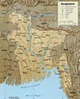
Bangladesh
is a low-lying, riverine country located in South Asia
with a largely marshy jungle coastline of 710 km (441 mi) on the northern littoral
of the Bay of Bengal
. Formed by a delta plain at the confluence of the Ganges (Padma)
, Brahmaputra (Jamuna)
, and Meghna River
s and their tributaries, Bangladesh's alluvial soil is highly fertile, but vulnerable to flood
and drought
. Hills rise above the plain only in the Chittagong Hill Tracts
in the far southeast and the Sylhet division in the northeast. Straddling the Tropic of Cancer
, Bangladesh has a tropical monsoon
climate characterized by heavy seasonal rainfall, high temperatures, and high humidity. Natural disasters, such as floods, tornadoes, and tidal bore
s affect the country yearly. Bangladesh also is affected by major cyclones, on average 16 times a decade. A cyclone struck the southeastern coast in May 1991, killing 136,000 people. Cyclone Sidr
struck the southwestern coast on November 15, 2007, affecting not only the coastal districts of the administrative division Khulna but also about half of the tropical forest Sundarbans
.
 The physical geography
of Bangladesh is varied and has an area characterized by two distinctive features: a broad deltaic
plain
subject to frequent flood
ing, and a small hilly region crossed by swiftly flowing rivers.The country has an area of 147,570 square kilometers and extends 820 kilometers north to south and 600 kilometers east to west. Bangladesh is bordered on the west, north, and east by a 4,095-kilometer land frontier with India
and, in the southeast, by a short land and water frontier (193 km) with Burma (Myanmar
). On the south is a highly irregular deltaic coastline of about 580 kilometers, fissured by many rivers and streams flowing into the Bay of Bengal
. The territorial waters
of Bangladesh extend 12 nautical miles (22.2 km), and the exclusive economic zone of the country is 200 nautical miles (370.4 km).
Roughly 80 % of the landmass is made up of fertile alluvial lowland called the Bangladesh Plain. The plain is part of the larger Plain of Bengal, which is sometimes called the Lower Gangetic Plain. Although altitudes up to 105 meters above sea level occur in the northern part of the plain, most elevations are less than 10 meters above sea level; elevations decrease in the coastal south, where the terrain is generally at sea level. With such low elevations and numerous rivers, water—and concomitant flooding—is a predominant physical feature. About 10,000 square kilometers of the total area of Bangladesh is covered with water, and larger areas are routinely flooded during the monsoon season.
The only exceptions to Bangladesh's low elevations are the Chittagong Hills in the southeast, the Low Hills of Sylhet in the northeast, and highlands in the north and northwest. The Chittagong Hills constitute the only significant hill system in the country and, in effect, are the western fringe of the north-south mountain ranges of Burma and eastern India. The Chittagong Hills rise steeply to narrow ridge lines, generally no wider than 36 meters, with altitude
s from 600 to 900 meters above sea level. At 1,052 meters altitude, the highest elevation in Bangladesh is found at Mowdok Mual
, in the southeastern part of the hills. Fertile valleys lie between the hill lines, which generally run north-south. West of the Chittagong Hills is a broad plain, cut by rivers draining into the Bay of Bengal, that rises to a final chain of low coastal hills, mostly below 200 meters, that attain a maximum elevation of 350 meters. West of these hills is a narrow, wet coastal plain located between the cities of Chittagong in the north and Cox's Bazar in the south.
About 67% of Bangladesh's nonurban land is arable. Permanent crops cover only 2%, meadows and pastures cover 4%, and forests and woodland cover about 16%. The country produces large quantities of quality timber, bamboo, and sugarcane. Bamboo grows in almost all areas, but high-quality timber grows mostly in the highland valleys. Rubber planting in the hilly regions of the country was undertaken in the 1980s, and rubber extraction had started by the end of the decade. A variety of wild animals are found in the forest areas, such as in the Sundarbans on the southwest coast, which is the home of the Royal Bengal Tiger. The alluvial soils in the Bangladesh Plain are generally fertile and are enriched with heavy silt deposits carried downstream during the rainy season.
and Comilla
are the most densely settled. The Sundarbans, an area of coastal tropical jungle in the southwest and last wild home of the Bengal Tiger
, and the Chittagong Hill Tracts on the southeastern border with Burma and India, are the least densely populated.
characterized by wide seasonal variations in rainfall, high temperatures, and high humidity. Regional climatic differences in this flat country are minor. Three seasons are generally recognized: a hot, muggy summer from March to June; a hot, humid and rainy monsoon season from June to November; and a warm-hot, dry winter from December to February. In general, maximum summer temperatures range between 38 and 41 °C (100.4 and 105.8 F). April is the hottest month in most parts of the country. January is the coolest month, when the average temperature for most of the country is 16–20 °C (60.8–68 F) during the day and around 10 °C (50 °F) at night. .
Winds are mostly from the north and northwest in the winter, blowing gently at 1 to 3 km/h (0.621371192734431 to 1.9 mph) in northern and central areas and 3 to 6 km/h (1.9 to 3.7 mph) near the coast. From March to May, violent thunderstorms, called northwesters by local English speakers, produce winds of up to 60 kilometres per hour (37.3 mph). During the intense storms of the early summer and late monsoon season, southerly winds of more than 160 kilometres per hour (99.4 mph) cause waves to crest as high as 6 metres (19.7 ft) in the Bay of Bengal, which brings disastrous flooding to coastal areas.
Heavy rainfall is characteristic of Bangladesh causing it to flood every year. With the exception of the relatively dry western region of Rajshahi , where the annual rainfall is about 1600 mm (63 in), most parts of the country receive at least 2300 mm (90.6 in) of rainfall per year. Because of its location just south of the foothills of the Himalayas, where monsoon winds turn west and northwest, the region of Sylhet in northeastern Bangladesh receives the greatest average precipitation. From 1977 to 1986, annual rainfall in that region ranged between 3280 and 4780 mm (129.1 and 188.2 in) per year. Average daily humidity ranged from March lows of between 55 and 81 % to July highs of between 94 and 100 %, based on readings taken at selected stations nationwide in 1986.
About 80 % of Bangladesh's rain falls during the monsoon season. The monsoons result from the contrasts between low and high air pressure areas that result from differential heating of land and water. During the hot months of April and May hot air rises over the Indian subcontinent, creating low-pressure areas into which rush cooler, moisture-bearing winds from the Indian Ocean. This is the southwest monsoon, commencing in June and usually lasting through September. Dividing against the Indian landmass, the monsoon flows in two branches, one of which strikes western India. The other travels up the Bay of Bengal and over eastern India and Bangladesh, crossing the plain to the north and northeast before being turned to the west and northwest by the foothills of the Himalayas.
Natural calamities, such as floods, tropical cyclones, tornadoes, and tidal bores—destructive waves or floods caused by flood tides rushing up estuaries—ravage the country, particularly the coastal belt, almost every year. Between 1947 and 1988, 13 severe cyclones hit Bangladesh, causing enormous loss of life and property. In May 1985, for example, a severe cyclonic storm packing 154 kilometres per hour (95.7 mph) winds and waves 4 metres (13.1 ft) high swept into southeastern and southern Bangladesh, killing more than 11,000 persons, damaging more than 94,000 houses, killing some 135,000 head of livestock, and damaging nearly 400 kilometres (248.5 mi) of critically needed embankments.
Annual monsoon flooding results in the loss of human life, damage to property and communication systems, and a shortage of drinking water, which leads to the spread of disease. For example, in 1988 two-thirds of Bangladesh's 64 districts experienced extensive flood damage in the wake of unusually heavy rains that flooded the river systems. Millions were left homeless and without potable water. Half of Dhaka, including the runways at the Shahjalal International Airport—an important transit point for disaster relief supplies—was flooded. About 2000000 t (2,204,623 ST; 1,968,407 LT) of crops were reported destroyed, and relief work was rendered even more challenging than usual because the flood made transportation of any kind exceedingly difficult. A tornado in April 1989 killed more than 600 people, possibly many more.
There are no precautions against cyclones and tidal bores except giving advance warning and providing safe public buildings where people may take shelter. Adequate infrastructure and air transport facilities that would ease the sufferings of the affected people had not been established by the late 1980s. Efforts by the government under the Third Five-Year Plan (1985–90) were directed toward accurate and timely forecast capability through agrometeorology, marine meteorology, oceanography, hydrometeorology, and seismology. Necessary expert services, equipment, and training facilities were expected to be developed under the United Nations Development Programme.
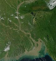
 The rivers of Bangladesh mark both the physiography of the nation and the life of the people. About 700 in number, these rivers generally flow south. The larger rivers serve as the main source of water for cultivation and as the principal arteries of commercial transportation. Rivers also provide fish, an important source of protein. Flooding of the rivers during the monsoon season causes enormous hardship and hinders development, but fresh deposits of rich silt replenish the fertile but overworked soil. The rivers also drain excess monsoon rainfall into the Bay of Bengal. Thus, the great river system is at the same time the country's principal resource and its greatest hazard.
The profusion of rivers can be divided into five major networks. The Jamuna-Brahmaputra is 292 kilometers long and extends from northern Bangladesh to its confluence with the Padma. Originating as the Yarlung Zangbo Jiang in China's Xizang Autonomous Region (Tibet) and flowing through India's state of Arunachal Pradesh, where it becomes known as the Brahmaputra ("Son of Brahma"), it receives waters from five major tributaries that total some 740 kilometers in length. At the point where the Brahmaputra meets the Tista River in Bangladesh, it becomes known as the Jamuna. The Jamuna is notorious for its shifting subchannels and for the formation of fertile silt islands (chars). No permanent settlements can exist along its banks.
The second system is the Padma-Ganges, which is divided into two sections: a 258-kilometer segment, the Ganges, which extends from the western border with India to its confluence with the Jamuna some 72 kilometers west of Dhaka, and a 126-kilometer segment, the Padma, which runs from the Ganges-Jamuna confluence to where it joins the Meghna River at Chandpur. The Padma-Ganges is the central part of a deltaic river system with hundreds of rivers and streams—some 2,100 kilometers in length—flowing generally east or west into the Padma.
The third network is the Surma-Meghna River System
, which courses from the northeastern border with India to Chandpur, where it joins the Padma. The Surma-Meghna, at 669 kilometers by itself the longest river in Bangladesh, is formed by the union of six lesser rivers. Below the city of Kalipur it is known as the Meghna. When the Padma and Meghna join together, they form the fourth river system—the Padma-Meghna—which flows 145 kilometers to the Bay of Bengal.
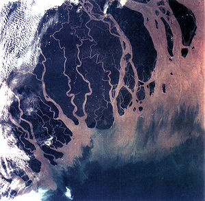
This mighty network of four river systems flowing through the Bangladesh Plain drains an area of some 1.5 million square kilometers. The numerous channels of the Padma-Meghna, its distributaries, and smaller parallel rivers that flow into the Bay of Bengal are referred to as the Mouths of the Ganges. Like the Jamuna, the Padma-Meghna and other estuaries on the Bay of Bengal are also known for their many chars.
A fifth river system, unconnected to the other four, is the Karnaphuli. Flowing through the region of Chittagong and the Chittagong Hills, it cuts across the hills and runs rapidly downhill to the west and southwest and then to the sea. The Feni, Karnaphuli, Sangu, and Matamuhari—an aggregate of some 420 kilometers—are the main rivers in the region. The port of Chittagong is situated on the banks of the Karnaphuli. The Karnaphuli Reservoir and Karnaphuli Dam are located in this area. The dam impounds the Karnaphuli River's waters in the reservoir for the generation of hydroelectric power.
During the annual monsoon period, the rivers of Bangladesh flow at about 140,000 cubic meters per second, but during the dry period they diminish to 7,000 cubic meters per second. Because water is so vital to agriculture, more than 60 % of the net arable land, some 91,000 km², is cultivated in the rainy season despite the possibility of severe flooding, and nearly 40 % of the land is cultivated during the dry winter months. Water resources development has responded to this "dual water regime" by providing flood protection, drainage to prevent overflooding and waterlogging, and irrigation facilities for the expansion of winter cultivation. Major water control projects have been developed by the national government to provide irrigation, flood control, drainage facilities, aids to river navigation and road construction, and hydroelectric power. In addition, thousands of tube wells and electric pumps are used for local irrigation. Despite severe resource constraints, the government of Bangladesh has made it a policy to try to bring additional areas under irrigation without salinity intrusion.
Water resources management, including gravity flow irrigation, flood control, and drainage, were largely the responsibility of the Bangladesh Water Development Board. Other public sector institutions, such as the Bangladesh Krishi Bank, the Bangladesh Rural Development Board, the Bangladesh Bank, and the Bangladesh Agricultural Development Corporation were also responsible for promotion and development of minor irrigation works in the private sector through government credit mechanisms.
total: 147,570 km²
country comparison to the world: 94
land: 133,910 km²
water: 10,090 km²
Area comparative:
Land boundaries:
total: 4,246 km
border countries: Myanmar 193 km, India 4,053 km
Coastline: 580 km
Maritime claims:
contiguous zone: 18 nmi (33.3 km; 20.7 mi)
continental shelf: up to the outer limits of the continental margin
exclusive economic zone: 200 nmi (370.4 km; 230.2 mi)
territorial sea: 12 nmi (22.2 km; 13.8 mi)
Elevation extremes:
lowest point: Indian Ocean
0 m
highest point: In the Mowdok range at 1052 m (at N 21°47'12" E 92°36'36"), NOT Keokradong
(883 m not 1,230 m) or Tajingdong (985 m not 1,280 m as sometimes reported)
, arable land
, timber
, coal
Land use:
Arable land
: 55.39%
Permanent crops: 3.08%
other: 41.53% (2005)
Irrigated land: 47,250 km² (2003)
Total renewable water resources: 1,210.6 km³ (1999)
Freshwater withdrawal (domestic/industrial/agricultural):
total: 79.4 km³/yr (3%/1%/96%)
per capita: 560 m³/yr (2000)
Cyclones; much of the country routinely swamped with water during the summer monsoon season; droughts
Environment - current issues:
many people are landless and forced to live on and cultivate flood-prone land; limited access to potable water; water-borne diseases prevalent; water pollution especially of fishing areas results from the use of commercial pesticides; ground water contaminated by naturally occurring arsenic
; intermittent water shortages because of falling water tables in the northern and central parts of the country; soil degradation and erosion; deforestation; severe overpopulation
Environment - international agreements:
party to:
Biodiversity, Climate Change, Climate Change-Kyoto Protocol, Desertification, Endangered Species, Environmental Modification, Hazardous Wastes, Law of the Sea, Ozone Layer Protection, Ship Pollution, Wetlands
signed, but not ratified: none of the selected agreements
; the Ganges unites with the Jamuna (main channel of the Brahmaputra) and later joins the Meghna to eventually empty into the Bay of Bengal
Bangladesh
Bangladesh , officially the People's Republic of Bangladesh is a sovereign state located in South Asia. It is bordered by India on all sides except for a small border with Burma to the far southeast and by the Bay of Bengal to the south...
is a low-lying, riverine country located in South Asia
South Asia
South Asia, also known as Southern Asia, is the southern region of the Asian continent, which comprises the sub-Himalayan countries and, for some authorities , also includes the adjoining countries to the west and the east...
with a largely marshy jungle coastline of 710 km (441 mi) on the northern littoral
Littoral
The littoral zone is that part of a sea, lake or river that is close to the shore. In coastal environments the littoral zone extends from the high water mark, which is rarely inundated, to shoreline areas that are permanently submerged. It always includes this intertidal zone and is often used to...
of the Bay of Bengal
Bay of Bengal
The Bay of Bengal , the largest bay in the world, forms the northeastern part of the Indian Ocean. It resembles a triangle in shape, and is bordered mostly by the Eastern Coast of India, southern coast of Bangladesh and Sri Lanka to the west and Burma and the Andaman and Nicobar Islands to the...
. Formed by a delta plain at the confluence of the Ganges (Padma)
Ganges River
The Ganges or Ganga, , is a trans-boundary river of India and Bangladesh. The river rises in the western Himalayas in the Indian state of Uttarakhand, and flows south and east through the Gangetic Plain of North India into Bangladesh, where it empties into the Bay of Bengal. By discharge it...
, Brahmaputra (Jamuna)
Brahmaputra River
The Brahmaputra , also called Tsangpo-Brahmaputra, is a trans-boundary river and one of the major rivers of Asia. It is the only Indian river that is attributed the masculine gender and thus referred to as a in Indo-Aryan languages and languages with Indo-Aryan influence...
, and Meghna River
Meghna River
The Meghna River is an important river in Bangladesh, one of the three that forms the Ganges Delta, the largest on earth fanning out to the Bay of Bengal. Being a part of the Surma-Meghna River System, Meghna is formed inside Bangladesh by the joining of different rivers originaing from the hilly...
s and their tributaries, Bangladesh's alluvial soil is highly fertile, but vulnerable to flood
Flood
A flood is an overflow of an expanse of water that submerges land. The EU Floods directive defines a flood as a temporary covering by water of land not normally covered by water...
and drought
Drought
A drought is an extended period of months or years when a region notes a deficiency in its water supply. Generally, this occurs when a region receives consistently below average precipitation. It can have a substantial impact on the ecosystem and agriculture of the affected region...
. Hills rise above the plain only in the Chittagong Hill Tracts
Chittagong Hill Tracts
The Chittagong Hill Tracts comprise an area of 13,295 km2 in south-eastern Bangladesh, and borders India and Myanmar . It was a single district of Bangladesh until 1984. In that year it was divided into three separate districts: Khagrachari, Rangamati and Bandarban. Topographically, this is the...
in the far southeast and the Sylhet division in the northeast. Straddling the Tropic of Cancer
Tropic of Cancer
The Tropic of Cancer, also referred to as the Northern tropic, is the circle of latitude on the Earth that marks the most northerly position at which the Sun may appear directly overhead at its zenith...
, Bangladesh has a tropical monsoon
Monsoon
Monsoon is traditionally defined as a seasonal reversing wind accompanied by corresponding changes in precipitation, but is now used to describe seasonal changes in atmospheric circulation and precipitation associated with the asymmetric heating of land and sea...
climate characterized by heavy seasonal rainfall, high temperatures, and high humidity. Natural disasters, such as floods, tornadoes, and tidal bore
Tidal bore
A tidal bore is a tidal phenomenon in which the leading edge of the incoming tide forms a wave of water that travel up a river or narrow bay against the direction of the river or bay's current...
s affect the country yearly. Bangladesh also is affected by major cyclones, on average 16 times a decade. A cyclone struck the southeastern coast in May 1991, killing 136,000 people. Cyclone Sidr
Cyclone Sidr
Cyclone Sidr was the strongest named cyclone in the Bay of Bengal...
struck the southwestern coast on November 15, 2007, affecting not only the coastal districts of the administrative division Khulna but also about half of the tropical forest Sundarbans
Sundarbans
The Sundarbans [Sundarban Tour Booking-9051115228] is the largest single block of tidal halophytic mangrove forest in the world.The name Sundarban can be literally translated as "beautiful jungle" or "beautiful forest" in the Bengali language...
.
Physical geography
Physical geography
Physical geography is one of the two major subfields of geography. Physical geography is that branch of natural science which deals with the study of processes and patterns in the natural environment like the atmosphere, biosphere and geosphere, as opposed to the cultural or built environment, the...
of Bangladesh is varied and has an area characterized by two distinctive features: a broad deltaic
River delta
A delta is a landform that is formed at the mouth of a river where that river flows into an ocean, sea, estuary, lake, reservoir, flat arid area, or another river. Deltas are formed from the deposition of the sediment carried by the river as the flow leaves the mouth of the river...
plain
Plain
In geography, a plain is land with relatively low relief, that is flat or gently rolling. Prairies and steppes are types of plains, and the archetype for a plain is often thought of as a grassland, but plains in their natural state may also be covered in shrublands, woodland and forest, or...
subject to frequent flood
Flood
A flood is an overflow of an expanse of water that submerges land. The EU Floods directive defines a flood as a temporary covering by water of land not normally covered by water...
ing, and a small hilly region crossed by swiftly flowing rivers.The country has an area of 147,570 square kilometers and extends 820 kilometers north to south and 600 kilometers east to west. Bangladesh is bordered on the west, north, and east by a 4,095-kilometer land frontier with India
India
India , officially the Republic of India , is a country in South Asia. It is the seventh-largest country by geographical area, the second-most populous country with over 1.2 billion people, and the most populous democracy in the world...
and, in the southeast, by a short land and water frontier (193 km) with Burma (Myanmar
Myanmar
Burma , officially the Republic of the Union of Myanmar , is a country in Southeast Asia. Burma is bordered by China on the northeast, Laos on the east, Thailand on the southeast, Bangladesh on the west, India on the northwest, the Bay of Bengal to the southwest, and the Andaman Sea on the south....
). On the south is a highly irregular deltaic coastline of about 580 kilometers, fissured by many rivers and streams flowing into the Bay of Bengal
Bay of Bengal
The Bay of Bengal , the largest bay in the world, forms the northeastern part of the Indian Ocean. It resembles a triangle in shape, and is bordered mostly by the Eastern Coast of India, southern coast of Bangladesh and Sri Lanka to the west and Burma and the Andaman and Nicobar Islands to the...
. The territorial waters
Territorial waters
Territorial waters, or a territorial sea, as defined by the 1982 United Nations Convention on the Law of the Sea, is a belt of coastal waters extending at most from the baseline of a coastal state...
of Bangladesh extend 12 nautical miles (22.2 km), and the exclusive economic zone of the country is 200 nautical miles (370.4 km).
Roughly 80 % of the landmass is made up of fertile alluvial lowland called the Bangladesh Plain. The plain is part of the larger Plain of Bengal, which is sometimes called the Lower Gangetic Plain. Although altitudes up to 105 meters above sea level occur in the northern part of the plain, most elevations are less than 10 meters above sea level; elevations decrease in the coastal south, where the terrain is generally at sea level. With such low elevations and numerous rivers, water—and concomitant flooding—is a predominant physical feature. About 10,000 square kilometers of the total area of Bangladesh is covered with water, and larger areas are routinely flooded during the monsoon season.
The only exceptions to Bangladesh's low elevations are the Chittagong Hills in the southeast, the Low Hills of Sylhet in the northeast, and highlands in the north and northwest. The Chittagong Hills constitute the only significant hill system in the country and, in effect, are the western fringe of the north-south mountain ranges of Burma and eastern India. The Chittagong Hills rise steeply to narrow ridge lines, generally no wider than 36 meters, with altitude
Altitude
Altitude or height is defined based on the context in which it is used . As a general definition, altitude is a distance measurement, usually in the vertical or "up" direction, between a reference datum and a point or object. The reference datum also often varies according to the context...
s from 600 to 900 meters above sea level. At 1,052 meters altitude, the highest elevation in Bangladesh is found at Mowdok Mual
Mowdok Mual
Mowdok Mual or Shaka Haphong is a peak in Bangladesh, often considered the highest point of this country, with an altitude of 1,052 metres . It is located on the border between Bangladesh and Burma....
, in the southeastern part of the hills. Fertile valleys lie between the hill lines, which generally run north-south. West of the Chittagong Hills is a broad plain, cut by rivers draining into the Bay of Bengal, that rises to a final chain of low coastal hills, mostly below 200 meters, that attain a maximum elevation of 350 meters. West of these hills is a narrow, wet coastal plain located between the cities of Chittagong in the north and Cox's Bazar in the south.
About 67% of Bangladesh's nonurban land is arable. Permanent crops cover only 2%, meadows and pastures cover 4%, and forests and woodland cover about 16%. The country produces large quantities of quality timber, bamboo, and sugarcane. Bamboo grows in almost all areas, but high-quality timber grows mostly in the highland valleys. Rubber planting in the hilly regions of the country was undertaken in the 1980s, and rubber extraction had started by the end of the decade. A variety of wild animals are found in the forest areas, such as in the Sundarbans on the southwest coast, which is the home of the Royal Bengal Tiger. The alluvial soils in the Bangladesh Plain are generally fertile and are enriched with heavy silt deposits carried downstream during the rainy season.
Human geography
Urbanization is proceeding rapidly, and it is estimated that only 30% of the population entering the labor force in the future will be absorbed into agriculture, although many will likely find other kinds of work in rural areas. The areas around DhakaDhaka
Dhaka is the capital of Bangladesh and the principal city of Dhaka Division. Dhaka is a megacity and one of the major cities of South Asia. Located on the banks of the Buriganga River, Dhaka, along with its metropolitan area, had a population of over 15 million in 2010, making it the largest city...
and Comilla
Comilla
Comilla is a city in south-eastern Bangladesh, located along the Dhaka-Chittagong Highway. It is the administrative center of the Comilla District, part of the Chittagong Division. The Eastern Wing of Bangladesh Highway Police is located in Comilla....
are the most densely settled. The Sundarbans, an area of coastal tropical jungle in the southwest and last wild home of the Bengal Tiger
Bengal Tiger
The Bengal tiger is a tiger subspecies native to the Indian subcontinent that in 2010 has been classified as endangered by IUCN...
, and the Chittagong Hill Tracts on the southeastern border with Burma and India, are the least densely populated.
Climate
Bangladesh has a tropical monsoon climateTropical monsoon climate
Tropical monsoon climate, occasionally also known as a tropical wet climate or tropical monsoon and trade-wind littoral climate in climate classification, is a relatively rare type of climate that corresponds to the Köppen climate classification category "Am."Tropical monsoon climates have monthly...
characterized by wide seasonal variations in rainfall, high temperatures, and high humidity. Regional climatic differences in this flat country are minor. Three seasons are generally recognized: a hot, muggy summer from March to June; a hot, humid and rainy monsoon season from June to November; and a warm-hot, dry winter from December to February. In general, maximum summer temperatures range between 38 and 41 °C (100.4 and 105.8 F). April is the hottest month in most parts of the country. January is the coolest month, when the average temperature for most of the country is 16–20 °C (60.8–68 F) during the day and around 10 °C (50 °F) at night. .
Winds are mostly from the north and northwest in the winter, blowing gently at 1 to 3 km/h (0.621371192734431 to 1.9 mph) in northern and central areas and 3 to 6 km/h (1.9 to 3.7 mph) near the coast. From March to May, violent thunderstorms, called northwesters by local English speakers, produce winds of up to 60 kilometres per hour (37.3 mph). During the intense storms of the early summer and late monsoon season, southerly winds of more than 160 kilometres per hour (99.4 mph) cause waves to crest as high as 6 metres (19.7 ft) in the Bay of Bengal, which brings disastrous flooding to coastal areas.
Heavy rainfall is characteristic of Bangladesh causing it to flood every year. With the exception of the relatively dry western region of Rajshahi , where the annual rainfall is about 1600 mm (63 in), most parts of the country receive at least 2300 mm (90.6 in) of rainfall per year. Because of its location just south of the foothills of the Himalayas, where monsoon winds turn west and northwest, the region of Sylhet in northeastern Bangladesh receives the greatest average precipitation. From 1977 to 1986, annual rainfall in that region ranged between 3280 and 4780 mm (129.1 and 188.2 in) per year. Average daily humidity ranged from March lows of between 55 and 81 % to July highs of between 94 and 100 %, based on readings taken at selected stations nationwide in 1986.
About 80 % of Bangladesh's rain falls during the monsoon season. The monsoons result from the contrasts between low and high air pressure areas that result from differential heating of land and water. During the hot months of April and May hot air rises over the Indian subcontinent, creating low-pressure areas into which rush cooler, moisture-bearing winds from the Indian Ocean. This is the southwest monsoon, commencing in June and usually lasting through September. Dividing against the Indian landmass, the monsoon flows in two branches, one of which strikes western India. The other travels up the Bay of Bengal and over eastern India and Bangladesh, crossing the plain to the north and northeast before being turned to the west and northwest by the foothills of the Himalayas.
Natural calamities, such as floods, tropical cyclones, tornadoes, and tidal bores—destructive waves or floods caused by flood tides rushing up estuaries—ravage the country, particularly the coastal belt, almost every year. Between 1947 and 1988, 13 severe cyclones hit Bangladesh, causing enormous loss of life and property. In May 1985, for example, a severe cyclonic storm packing 154 kilometres per hour (95.7 mph) winds and waves 4 metres (13.1 ft) high swept into southeastern and southern Bangladesh, killing more than 11,000 persons, damaging more than 94,000 houses, killing some 135,000 head of livestock, and damaging nearly 400 kilometres (248.5 mi) of critically needed embankments.
Annual monsoon flooding results in the loss of human life, damage to property and communication systems, and a shortage of drinking water, which leads to the spread of disease. For example, in 1988 two-thirds of Bangladesh's 64 districts experienced extensive flood damage in the wake of unusually heavy rains that flooded the river systems. Millions were left homeless and without potable water. Half of Dhaka, including the runways at the Shahjalal International Airport—an important transit point for disaster relief supplies—was flooded. About 2000000 t (2,204,623 ST; 1,968,407 LT) of crops were reported destroyed, and relief work was rendered even more challenging than usual because the flood made transportation of any kind exceedingly difficult. A tornado in April 1989 killed more than 600 people, possibly many more.
There are no precautions against cyclones and tidal bores except giving advance warning and providing safe public buildings where people may take shelter. Adequate infrastructure and air transport facilities that would ease the sufferings of the affected people had not been established by the late 1980s. Efforts by the government under the Third Five-Year Plan (1985–90) were directed toward accurate and timely forecast capability through agrometeorology, marine meteorology, oceanography, hydrometeorology, and seismology. Necessary expert services, equipment, and training facilities were expected to be developed under the United Nations Development Programme.
River systems
The profusion of rivers can be divided into five major networks. The Jamuna-Brahmaputra is 292 kilometers long and extends from northern Bangladesh to its confluence with the Padma. Originating as the Yarlung Zangbo Jiang in China's Xizang Autonomous Region (Tibet) and flowing through India's state of Arunachal Pradesh, where it becomes known as the Brahmaputra ("Son of Brahma"), it receives waters from five major tributaries that total some 740 kilometers in length. At the point where the Brahmaputra meets the Tista River in Bangladesh, it becomes known as the Jamuna. The Jamuna is notorious for its shifting subchannels and for the formation of fertile silt islands (chars). No permanent settlements can exist along its banks.
The second system is the Padma-Ganges, which is divided into two sections: a 258-kilometer segment, the Ganges, which extends from the western border with India to its confluence with the Jamuna some 72 kilometers west of Dhaka, and a 126-kilometer segment, the Padma, which runs from the Ganges-Jamuna confluence to where it joins the Meghna River at Chandpur. The Padma-Ganges is the central part of a deltaic river system with hundreds of rivers and streams—some 2,100 kilometers in length—flowing generally east or west into the Padma.
The third network is the Surma-Meghna River System
Surma-Meghna River System
The Surma-Meghna River System is a river complex in South Asia, one of the three that form the Ganges Delta, the largest on earth. It rises in the Manipur Hills of northeast India as the Barak River and flows west becoming the Surma River and then flows south as the Meghna River, a total of...
, which courses from the northeastern border with India to Chandpur, where it joins the Padma. The Surma-Meghna, at 669 kilometers by itself the longest river in Bangladesh, is formed by the union of six lesser rivers. Below the city of Kalipur it is known as the Meghna. When the Padma and Meghna join together, they form the fourth river system—the Padma-Meghna—which flows 145 kilometers to the Bay of Bengal.
This mighty network of four river systems flowing through the Bangladesh Plain drains an area of some 1.5 million square kilometers. The numerous channels of the Padma-Meghna, its distributaries, and smaller parallel rivers that flow into the Bay of Bengal are referred to as the Mouths of the Ganges. Like the Jamuna, the Padma-Meghna and other estuaries on the Bay of Bengal are also known for their many chars.
A fifth river system, unconnected to the other four, is the Karnaphuli. Flowing through the region of Chittagong and the Chittagong Hills, it cuts across the hills and runs rapidly downhill to the west and southwest and then to the sea. The Feni, Karnaphuli, Sangu, and Matamuhari—an aggregate of some 420 kilometers—are the main rivers in the region. The port of Chittagong is situated on the banks of the Karnaphuli. The Karnaphuli Reservoir and Karnaphuli Dam are located in this area. The dam impounds the Karnaphuli River's waters in the reservoir for the generation of hydroelectric power.
During the annual monsoon period, the rivers of Bangladesh flow at about 140,000 cubic meters per second, but during the dry period they diminish to 7,000 cubic meters per second. Because water is so vital to agriculture, more than 60 % of the net arable land, some 91,000 km², is cultivated in the rainy season despite the possibility of severe flooding, and nearly 40 % of the land is cultivated during the dry winter months. Water resources development has responded to this "dual water regime" by providing flood protection, drainage to prevent overflooding and waterlogging, and irrigation facilities for the expansion of winter cultivation. Major water control projects have been developed by the national government to provide irrigation, flood control, drainage facilities, aids to river navigation and road construction, and hydroelectric power. In addition, thousands of tube wells and electric pumps are used for local irrigation. Despite severe resource constraints, the government of Bangladesh has made it a policy to try to bring additional areas under irrigation without salinity intrusion.
Water resources management, including gravity flow irrigation, flood control, and drainage, were largely the responsibility of the Bangladesh Water Development Board. Other public sector institutions, such as the Bangladesh Krishi Bank, the Bangladesh Rural Development Board, the Bangladesh Bank, and the Bangladesh Agricultural Development Corporation were also responsible for promotion and development of minor irrigation works in the private sector through government credit mechanisms.
Area and boundaries
Area:total: 147,570 km²
country comparison to the world: 94
land: 133,910 km²
water: 10,090 km²
Area comparative:
- AustraliaAustraliaAustralia , officially the Commonwealth of Australia, is a country in the Southern Hemisphere comprising the mainland of the Australian continent, the island of Tasmania, and numerous smaller islands in the Indian and Pacific Oceans. It is the world's sixth-largest country by total area...
comparative: 1.5 times larger than TasmaniaTasmaniaTasmania is an Australian island and state. It is south of the continent, separated by Bass Strait. The state includes the island of Tasmania—the 26th largest island in the world—and the surrounding islands. The state has a population of 507,626 , of whom almost half reside in the greater Hobart... - CanadaCanadaCanada is a North American country consisting of ten provinces and three territories. Located in the northern part of the continent, it extends from the Atlantic Ocean in the east to the Pacific Ocean in the west, and northward into the Arctic Ocean...
comparative: twice the size of New BrunswickNew BrunswickNew Brunswick is one of Canada's three Maritime provinces and is the only province in the federation that is constitutionally bilingual . The provincial capital is Fredericton and Saint John is the most populous city. Greater Moncton is the largest Census Metropolitan Area... - United KingdomUnited KingdomThe United Kingdom of Great Britain and Northern IrelandIn the United Kingdom and Dependencies, other languages have been officially recognised as legitimate autochthonous languages under the European Charter for Regional or Minority Languages...
comparative: larger than EnglandEnglandEngland is a country that is part of the United Kingdom. It shares land borders with Scotland to the north and Wales to the west; the Irish Sea is to the north west, the Celtic Sea to the south west, with the North Sea to the east and the English Channel to the south separating it from continental... - United StatesUnited StatesThe United States of America is a federal constitutional republic comprising fifty states and a federal district...
comparative: slightly larger than IowaIowaIowa is a state located in the Midwestern United States, an area often referred to as the "American Heartland". It derives its name from the Ioway people, one of the many American Indian tribes that occupied the state at the time of European exploration. Iowa was a part of the French colony of New...
Land boundaries:
total: 4,246 km
border countries: Myanmar 193 km, India 4,053 km
Coastline: 580 km
Maritime claims:
contiguous zone: 18 nmi (33.3 km; 20.7 mi)
continental shelf: up to the outer limits of the continental margin
Continental margin
The continental margin is the zone of the ocean floor that separates the thin oceanic crust from thick continental crust. Continental margins constitute about 28% of the oceanic area....
exclusive economic zone: 200 nmi (370.4 km; 230.2 mi)
territorial sea: 12 nmi (22.2 km; 13.8 mi)
Elevation extremes:
lowest point: Indian Ocean
Indian Ocean
The Indian Ocean is the third largest of the world's oceanic divisions, covering approximately 20% of the water on the Earth's surface. It is bounded on the north by the Indian Subcontinent and Arabian Peninsula ; on the west by eastern Africa; on the east by Indochina, the Sunda Islands, and...
0 m
highest point: In the Mowdok range at 1052 m (at N 21°47'12" E 92°36'36"), NOT Keokradong
Keokradong
Keokradong is the third highest mountain peak located in South-Eastern Bangladesh. It was long claimed as the highest peak there, a mistaken information that still features in respected sources including some Bangladesh textbooks as well as the CIA World Factbook website.-Keokradong:Although it...
(883 m not 1,230 m) or Tajingdong (985 m not 1,280 m as sometimes reported)
Resources and land use
Natural resources: natural gasNatural gas
Natural gas is a naturally occurring gas mixture consisting primarily of methane, typically with 0–20% higher hydrocarbons . It is found associated with other hydrocarbon fuel, in coal beds, as methane clathrates, and is an important fuel source and a major feedstock for fertilizers.Most natural...
, arable land
Arable land
In geography and agriculture, arable land is land that can be used for growing crops. It includes all land under temporary crops , temporary meadows for mowing or pasture, land under market and kitchen gardens and land temporarily fallow...
, timber
Timber
Timber may refer to:* Timber, a term common in the United Kingdom and Australia for wood materials * Timber, Oregon, an unincorporated community in the U.S...
, coal
Coal
Coal is a combustible black or brownish-black sedimentary rock usually occurring in rock strata in layers or veins called coal beds or coal seams. The harder forms, such as anthracite coal, can be regarded as metamorphic rock because of later exposure to elevated temperature and pressure...
Land use:
Arable land
Arable land
In geography and agriculture, arable land is land that can be used for growing crops. It includes all land under temporary crops , temporary meadows for mowing or pasture, land under market and kitchen gardens and land temporarily fallow...
: 55.39%
Permanent crops: 3.08%
other: 41.53% (2005)
Irrigated land: 47,250 km² (2003)
Total renewable water resources: 1,210.6 km³ (1999)
Freshwater withdrawal (domestic/industrial/agricultural):
total: 79.4 km³/yr (3%/1%/96%)
per capita: 560 m³/yr (2000)
Environmental concerns
Natural hazards:Cyclones; much of the country routinely swamped with water during the summer monsoon season; droughts
Environment - current issues:
many people are landless and forced to live on and cultivate flood-prone land; limited access to potable water; water-borne diseases prevalent; water pollution especially of fishing areas results from the use of commercial pesticides; ground water contaminated by naturally occurring arsenic
Arsenic
Arsenic is a chemical element with the symbol As, atomic number 33 and relative atomic mass 74.92. Arsenic occurs in many minerals, usually in conjunction with sulfur and metals, and also as a pure elemental crystal. It was first documented by Albertus Magnus in 1250.Arsenic is a metalloid...
; intermittent water shortages because of falling water tables in the northern and central parts of the country; soil degradation and erosion; deforestation; severe overpopulation
Environment - international agreements:
party to:
Biodiversity, Climate Change, Climate Change-Kyoto Protocol, Desertification, Endangered Species, Environmental Modification, Hazardous Wastes, Law of the Sea, Ozone Layer Protection, Ship Pollution, Wetlands
signed, but not ratified: none of the selected agreements
Geography-note
Most of the country is situated on deltas of large rivers flowing from the HimalayasHimalayas
The Himalaya Range or Himalaya Mountains Sanskrit: Devanagari: हिमालय, literally "abode of snow"), usually called the Himalayas or Himalaya for short, is a mountain range in Asia, separating the Indian subcontinent from the Tibetan Plateau...
; the Ganges unites with the Jamuna (main channel of the Brahmaputra) and later joins the Meghna to eventually empty into the Bay of Bengal
Bay of Bengal
The Bay of Bengal , the largest bay in the world, forms the northeastern part of the Indian Ocean. It resembles a triangle in shape, and is bordered mostly by the Eastern Coast of India, southern coast of Bangladesh and Sri Lanka to the west and Burma and the Andaman and Nicobar Islands to the...
See also
- 2007 South Asian floods2007 South Asian floodsThe 2007 South Asian floods were a series of floods in India, Nepal, Bhutan, Pakistan and Bangladesh. News Agencies, citing the Indian and Bangladeshi governments, place the death toll in excess of 2,000...
- BangladeshBangladeshBangladesh , officially the People's Republic of Bangladesh is a sovereign state located in South Asia. It is bordered by India on all sides except for a small border with Burma to the far southeast and by the Bay of Bengal to the south...
- Bangladesh climate Multi Donor Trust FundBangladesh climate Multi Donor Trust FundThe Bangladesh climate Multi Donor Trust Fund is a proposed institution to collect and disburse climate adaptation funding for Bangladesh, to be administered by the World Bank....
- List of floods in Bangladesh
- List of islands of Bangladesh