Cyclone Sidr was the strongest named cyclone in the Bay of Bengal. The fourth named storm of the 2007 North Indian Ocean cyclone season, Sidr formed in the central
Bay of BengalThe Bay of Bengal , the largest bay in the world, forms the northeastern part of the Indian Ocean. It resembles a triangle in shape, and is bordered mostly by the Eastern Coast of India, southern coast of Bangladesh and Sri Lanka to the west and Burma and the Andaman and Nicobar Islands to the...
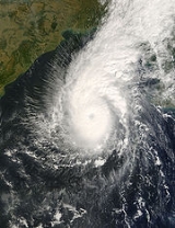
, and quickly strengthened to reach peak 1-minute sustained winds of 260 km/h (160 mp/h), which would make it a Category-5 equivalent tropical cyclone on the
Saffir-Simpson ScaleThe Saffir–Simpson Hurricane Scale , or the Saffir–Simpson Hurricane Wind Scale , classifies hurricanes — Western Hemisphere tropical cyclones that exceed the intensities of tropical depressions and tropical storms — into five categories distinguished by the intensities of their sustained winds...
. The storm eventually made landfall in
BangladeshBangladesh , officially the People's Republic of Bangladesh is a sovereign state located in South Asia. It is bordered by India on all sides except for a small border with Burma to the far southeast and by the Bay of Bengal to the south...
on November 15, 2007. The storm caused large-scale evacuations. 3,447 deaths were blamed on the storm.
Save the ChildrenSave the Children is an internationally active non-governmental organization that enforces children's rights, provides relief and helps support children in developing countries...
estimated the number of deaths to be between 5,000 and 10,000, while the Red Crescent Society reported on November 18 that the number of deaths could be up to 10,000. International groups pledged US$95 million to repair the damage, which was estimated at $1.7 billion (2007 USD).
Meteorological history
On November 9, an area of disturbed weather developed southeast of the
Andaman IslandsThe Andaman Islands are a group of Indian Ocean archipelagic islands in the Bay of Bengal between India to the west, and Burma , to the north and east...
, with a weak low-level circulation near the
Nicobar IslandsThe Nicobar Islands are an archipelagic island chain in the eastern Indian Ocean...
. Initially moderate upper-level
wind shearWind shear, sometimes referred to as windshear or wind gradient, is a difference in wind speed and direction over a relatively short distance in the atmosphere...
inhibited organization, while strong diffluence aloft aided in developing convection. Vertical shear decreased greatly as the circulation became better defined, and a
Tropical Cyclone Formation AlertA Tropical Cyclone Formation Alert is a bulletin released by the U.S. Navy-operated Joint Typhoon Warning Center in Honolulu, Hawaii or the Naval Maritime Forecast Center in Norfolk, Virginia, warning of the possibility of a tropical cyclone forming from a tropical disturbance that has been...
was issued on November 11 while located a short distance south of the Andaman Islands. Around the same time, the
India Meteorological DepartmentThe India Meteorological Department , also referred to as the Met Office, is an agency of the Ministry of Earth Sciences of the Government of India. It is the principal agency responsible for meteorological observations, weather forecasting and seismology...
(IMD) designated the system as Depression BOB 09. The
Joint Typhoon Warning CenterThe Joint Typhoon Warning Center is a joint United States Navy – United States Air Force task force located at the Naval Maritime Forecast Center in Pearl Harbor, Hawaii...
(JTWC) upgraded it to Tropical Cyclone 06B after
Dvorak estimatesThe Dvorak technique is a widely used system to subjectively estimate tropical cyclone intensity based solely on visible and infrared satellite images. Several agencies issue Dvorak intensity numbers for cyclones of sufficient intensity...
indicated winds of 65 km/h (40 mph). Later that day, it intensified into a deep depression as it moved slowly north-westward.
The IMD upgraded the system to Cyclonic Storm Sidr early on November 12. The system then began to intensify quickly as it moved slowly northwestward, and the IMD upgraded it to a severe cyclonic storm later that day and a very severe cyclonic storm early the next day. On the morning of November 15, the cyclone intensified to reach peak winds of 215 km/h (135 mph) according to the IMD, and a peak of 260 km/h (160 mph) according to the JTWC best track. Sidr officially made landfall around 1700
UTCCoordinated Universal Time is the primary time standard by which the world regulates clocks and time. It is one of several closely related successors to Greenwich Mean Time. Computer servers, online services and other entities that rely on having a universally accepted time use UTC for that purpose...
later that day, with sustained winds of 215 km/h (135 mph). It weakened quickly after landfall and the final advisories were issued early on November 16. The name Sidr was contributed by
OmanOman , officially called the Sultanate of Oman , is an Arab state in southwest Asia on the southeast coast of the Arabian Peninsula. It is bordered by the United Arab Emirates to the northwest, Saudi Arabia to the west, and Yemen to the southwest. The coast is formed by the Arabian Sea on the...
; it is an Arabic name of a tree belonging to the genus
ZiziphusZiziphus is a genus of about 40 species of spiny shrubs and small trees in the buckthorn family, Rhamnaceae, distributed in the warm-temperate and subtropical regions throughout the world. The leaves are alternate, entire, with three prominent basal veins, and long; some species are deciduous,...
, specifically the
Ziziphus spina-christi. There is another saying that it is derived from the Sinhalese Language where "Sidr" means 'hole' or 'eye.
Preparations
As it intensified to a Category 4-equivalent cyclone on November 15, thousands of emergency officials were put on standby in eastern India and
BangladeshBangladesh , officially the People's Republic of Bangladesh is a sovereign state located in South Asia. It is bordered by India on all sides except for a small border with Burma to the far southeast and by the Bay of Bengal to the south...
in advance of the storm's arrival. Forecast heights of the storm surge predicted by a numerical model developed by Dr. Hassan Mashriqui (
Louisiana State UniversityLouisiana State University and Agricultural and Mechanical College, most often referred to as Louisiana State University, or LSU, is a public coeducational university located in Baton Rouge, Louisiana. The University was founded in 1853 in what is now known as Pineville, Louisiana, under the name...
) was communicated to the emergency response authorities in Bangladesh, prompting a massive evacuations of low-lying coastal areas. A total of 2 million people in Bangladesh evacuated to emergency shelters. The Indian Metrological Department (IMD) also issued a cyclone alert for
OrissaOrissa , officially Odisha since Nov 2011, is a state of India, located on the east coast of India, by the Bay of Bengal. It is the modern name of the ancient nation of Kalinga, which was invaded by the Maurya Emperor Ashoka in 261 BC. The modern state of Orissa was established on 1 April...
and
West BengalWest Bengal is a state in the eastern region of India and is the nation's fourth-most populous. It is also the seventh-most populous sub-national entity in the world, with over 91 million inhabitants. A major agricultural producer, West Bengal is the sixth-largest contributor to India's GDP...
on November 14. In Bangladesh, an emergency cabinet meeting decided to withdraw weekly leave for the government officials to join the evacuation process. Over 40,000 Red Crescent volunteers were deployed to order residents in the 15 affected provinces into special cyclone and flood shelters. The main ports had been closed.
Impact
Coastal districts of Bangladesh faced heavy rainfall as an early impact of the cyclone.
DhakaDhaka is the capital of Bangladesh and the principal city of Dhaka Division. Dhaka is a megacity and one of the major cities of South Asia. Located on the banks of the Buriganga River, Dhaka, along with its metropolitan area, had a population of over 15 million in 2010, making it the largest city...
and other parts of Bangladesh experienced drizzle and gusty winds. Total damages came close to $450 million.
Storm surges reaching up to a height of 3 metres (9.8 ft) were reported in the coastal areas of north
ChennaiChennai , formerly known as Madras or Madarasapatinam , is the capital city of the Indian state of Tamil Nadu, located on the Coromandel Coast off the Bay of Bengal. Chennai is the fourth most populous metropolitan area and the sixth most populous city in India...
in southern state of
Tamil NaduTamil Nadu is one of the 28 states of India. Its capital and largest city is Chennai. Tamil Nadu lies in the southernmost part of the Indian Peninsula and is bordered by the union territory of Pondicherry, and the states of Kerala, Karnataka, and Andhra Pradesh...
in India, triggering panic among the fishing community.
The damage in Bangladesh was extensive, including tin shacks flattened, houses and schools blown away and enormous tree damage. Some local officials have described the damage as being even worse than that from the
1991 cyclone-External links:** from NIRAPAD disaster response organisation.**...
. The entire cities of Patuakhali, Barguna and Jhalokati District were hit hard by the storm surge of over 5 meters (16 ft). About a quarter of the world heritage site Sunderbans were damaged. Researchers said mangrove forest Sunderban will take at least 40 years to recover itself from this catastrophe.
Much of the capital city of
DhakaDhaka is the capital of Bangladesh and the principal city of Dhaka Division. Dhaka is a megacity and one of the major cities of South Asia. Located on the banks of the Buriganga River, Dhaka, along with its metropolitan area, had a population of over 15 million in 2010, making it the largest city...
was also severely affected, as electricity and water service were cut and significant damage was reported there due to winds and flooding. The local
agriculturalAgriculture is the cultivation of animals, plants, fungi and other life forms for food, fiber, and other products used to sustain life. Agriculture was the key implement in the rise of sedentary human civilization, whereby farming of domesticated species created food surpluses that nurtured the...
industry was also devastated, as many
riceRice is the seed of the monocot plants Oryza sativa or Oryza glaberrima . As a cereal grain, it is the most important staple food for a large part of the world's human population, especially in East Asia, Southeast Asia, South Asia, the Middle East, and the West Indies...
crops — which have a December harvest — were lost.
At least 3,447 deaths have been reported. The hardest-hit area was Barguna, where 423 people were reported to have been killed, according to local officials. Patuakhali was also hard-hit, with 385 deaths reported. Most of the deaths confirmed thus far were due to the winds, although 13 of them have been as a result of capsized boats in the Faridpur district of Bangladesh. The head of the Red Crescent in Bangladesh expects the death toll to reach as high as 10,000. Over 3,000 other fishermen were reported missing on over 500 fishing boats.
Disaster response
Cyclone Sidr slammed the highly vulnerable low lying densely populated coastal areas of Bangladesh with heavy rain, winds of up to 120 miles/hr, and a storm surge. Sidr may be the strongest cyclone to hit the country since
a cyclone-External links:** from NIRAPAD disaster response organisation.**...
killed over 143,000 Bangladeshis in 1991.
Although, the death from Sidr number in the hundreds but damage to homes, crops and livelihoods could be extensive. Under a Cyclone Preparedness Program, volunteers evacuated at least 600,000 Bangladeshis in the path of the storm. Many are housed in 1,800 multipurpose disaster shelters built along the coast. Relief organizations distributed seven-day emergency disaster kits of food, blankets and clothing for evacuated families.
Since 1991, the donor community, including the US and EC, has supported disaster-preparedness to mitigate the impact of tropical storms and improve post-disaster relief and reconstruction. Cyclone walls planted within trees are in place to protect vulnerable areas from storm surges. Disaster shelters on stilts housing refugees plus early warning systems and timely evacuations appear to have greatly reduced the fatalities from Sidr. It did kill 3,447 people, but this was much less than the 140,000 that died in 1991.
Aftermath
National response
After the storm, 18
Bangladesh Air ForceThe Bangladesh Air Force , is the air arm of the Bangladesh Armed Forces. Bangladesh Air Force currently employs more than 22,000 personnel including 600+ Pilots.-History:...
helicopters and five
Bangladesh NavyThe Bangladesh Navy is the naval arm of the Bangladesh Armed Forces. At present the navy is mostly limited to coastal patrolling, however it is implementing an ambitious procurement and expansion program to ensure the security of Bangladesh's maritime boundary...
ships were immediately dispatched with food, medicine, and relief supplies for the hardest-hit areas. Bangladesh Red Crescent Society initially asked 400 million Taka (US$5,807,594) to the international community. As part of the
Bangladeshi cricket team's tour in New ZealandThe Bangladesh cricket team toured New Zealand between December 19 2007 and January 16, 2008 to play three one day internationals and two Test matches. This was the second Bangladeshi tour to New Zealand and the third series between the countries following New Zealand's 2004-05 tour to Bangladesh...
, a charity
Twenty20Twenty20 is a form of cricket, originally introduced in England for professional inter-county competition by the England and Wales Cricket Board , in 2003. A Twenty20 game involves two teams, each has a single innings, batting for a maximum of 20 overs. Twenty20 cricket is also known as T20 cricket...
match was held with all funds raised going to the victims. In addition, the
International Cricket CouncilThe International Cricket Council is the international governing body of cricket. It was founded as the Imperial Cricket Conference in 1909 by representatives from England, Australia and South Africa, renamed the International Cricket Conference in 1965, and took up its current name in 1989.The...
donated US$250,000 to the funds at the start of the match. The Ministry of Food and Disaster Management allocated 4,000 metric tonnes of rice, 7,500 tents, 18,000 blankets, and 30 million Taka (US$435,569) in relief grants. About 13,000 housing packages, consisting of iron sheets for roofing and family kits were prepared for immediate distribution. A special 350 million Taka (US$5,081,645) fund for housing was established by November 22, 2007. At that time, 732 medical team were deployed to the affected areas.
International response
International communities had expanded their hands towards Bangladesh on this disaster. Below is a contribution list.
| Country / Institution |
Description |
Funding USD |
Uncommitted Pledges (in USD) |
| Australia |
safe water, sanitation, foods, clothes, blankets |
8294 |
2700000 |
| Belgium |
rehabilitation of houses, agricultural support |
3097157 |
0 |
| Bill and Melinda Gates foundation |
Humanitarian assistance |
500000 |
0 |
| Canada |
Health aid, non-food items, basic needs, foods, |
3700000 |
0 |
| Central emergency relief fund |
For protective health environment, support to reproductive health service, telecommunication support, nutrition supplement, |
19000000 |
0 |
| China |
Relief and rehabilitation |
0 |
1500000 |
| Denmark |
Humanitarian assistance |
2900000 |
0 |
| European commission humanitarian aid office |
Emergency assistance, foods, shelter, latrines, Relief and rehabilitation |
11000000 |
0 |
| Germany |
Foods, non-foods, |
3700000 |
0 |
| India |
medicine, foods, tents, blankets |
0 |
1000000 |
| Iran |
blankets, washing powder |
1300000 |
0 |
| Italy |
Foods |
6400000 |
0 |
| Japan |
Tents, blankets, sleeping mats, drinking water system, electricity generator |
1500000 |
2651862 |
| Korea, Republic of |
Foods,emergency relief |
100000 |
0 |
| Kuwait |
emergency assistance |
10000000 |
0 |
| Netherlands |
Humanitarian assistance, goods, transports |
9500000 |
0 |
| Norway |
water, sanitary, goods |
4000000 |
0 |
| Saudi Arabia |
Cash donation directly |
100000000 |
0 |
| Spain |
Foods, drinking water, tents, blankets, medicine |
200000 |
1080800 |
| Sweden |
Foods, sanitary, medicine, household |
3700000 |
0 |
| Switzerland |
emergency assistance |
1200000 |
0 |
| UK |
Foods, water, medicine |
163000 |
13000000 |
| USA |
Shelter, water, sanitation, medicine, hygiene, US Military Aid mission- formed by USS Tarawa, USS Kearsarge and stayed 1 month in cyclone affected area. |
3159353 |
0 |
Post-storm diseases
People of the cyclone affected area experienced severe health problems such as diseases like
diarrheaDiarrhea , also spelled diarrhoea, is the condition of having three or more loose or liquid bowel movements per day. It is a common cause of death in developing countries and the second most common cause of infant deaths worldwide. The loss of fluids through diarrhea can cause dehydration and...
, which spread due to shortage of drinking water. The landfall of Sidr had followed the devastation caused by consecutive floods earlier in 2007. By January 15, 2008, the
World Health OrganizationThe World Health Organization is a specialized agency of the United Nations that acts as a coordinating authority on international public health. Established on 7 April 1948, with headquarters in Geneva, Switzerland, the agency inherited the mandate and resources of its predecessor, the Health...
(WHO) reported that 44 people had
JaundiceJaundice is a yellowish pigmentation of the skin, the conjunctival membranes over the sclerae , and other mucous membranes caused by hyperbilirubinemia . This hyperbilirubinemia subsequently causes increased levels of bilirubin in the extracellular fluid...
, 3,572 had Diarrhoea, 3,210 had
PneumoniaPneumonia is an inflammatory condition of the lung—especially affecting the microscopic air sacs —associated with fever, chest symptoms, and a lack of air space on a chest X-ray. Pneumonia is typically caused by an infection but there are a number of other causes...
, 7,538 were suffering from a skin disease, 2,309 had eye infections, and 10,349 had
Typhoid FeverTyphoid fever, also known as Typhoid, is a common worldwide bacterial disease, transmitted by the ingestion of food or water contaminated with the feces of an infected person, which contain the bacterium Salmonella enterica, serovar Typhi...
. To help reduce further spreading of the diseases, the Government of Norway provided the WHO with four water treatment plants to be used in areas affected by Sidr.
See also
- List of Bangladesh tropical cyclones
- List of notable tropical cyclones
- List of North Indian cyclone seasons
- Geography of Bangladesh
Bangladesh is a low-lying, riverine country located in South Asia with a largely marshy jungle coastline of on the northern littoral of the Bay of Bengal. Formed by a delta plain at the confluence of the Ganges , Brahmaputra , and Meghna Rivers and their tributaries, Bangladesh's alluvial soil is...
- Timeline of the 2007 North Indian Ocean cyclone season
Below is a timeline of the 2007 North Indian Ocean cyclone season, documenting major events with regards to tropical cyclone formation, strengthening, weakening, landfall, extratropical transition, as well as dissipation...
External links
History of past cyclones in the Bay of Bengal (IMD)
BBC article on Cyclone Sidr
Automated Advanced Dvorak Technique estimate from UW-CIMSS
Crisis profile Cyclone Sidr From Reuters Alertnet