

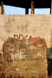
Keokradong
Encyclopedia
Mountain
Image:Himalaya_annotated.jpg|thumb|right|The Himalayan mountain range with Mount Everestrect 58 14 160 49 Chomo Lonzorect 200 28 335 52 Makalurect 378 24 566 45 Mount Everestrect 188 581 920 656 Tibetan Plateaurect 250 406 340 427 Rong River...
peak located in South-Eastern Bangladesh
Bangladesh
Bangladesh , officially the People's Republic of Bangladesh is a sovereign state located in South Asia. It is bordered by India on all sides except for a small border with Burma to the far southeast and by the Bay of Bengal to the south...
. It was long claimed as the highest peak there, a mistaken information that still features in respected sources including some Bangladesh textbooks as well as the CIA World Factbook website.
Keokradong
Although it is widely reported to be the highest point in Bangladesh at 1230 metres, recent SRTM data, GPS readings and Russian topographic mapping show that its true height is less than 1,000 metres.On the top of Keokradong there is a small shelter and a signboard put up by the Bangladeshi military proclaiming the altitude to be 3172 feet. Garmin GPS recorded 974 metres (3196 feet) at this location, a different team measured 986m with 3m accuracy by GPS, a measurement consistent with Russian topographic mapping and SRTM data. It is at 21°57′00"N 92°30′53"E. USGS and Russian mapping dispute the claim that this is the location correctly named Keokradong; they show Keokradong at an 883m summit further north.
Tazing Dong
Another peak that is sometimes claimed to be the highest peak of Bangladesh is nearby Tazing Dong (sometimes spelled as Tahjingdong, and also known as Bijoy). It has been claimed to be 1,280 metres. Its exact location is unclear but neither Russian topographic mapping nor SRTM data show anything in the area exceeding 1,000 metres.There are three peaks in that area known as Thajindong (Lungphe Tuang in US army 1:250K topo map and Russian 1:200k topo map). A local trekker team measured the highest two peaks and found the middle one (N 21° 49' 16.20" - E 92° 32' 11.61") is 871m (3m accuracy) and higher than the other peak which was at N 21° 48' 58.17" - E 92° 31' 49.87" with 829m (accuracy 3m) measured height. A different measurement done by another team using Garmin GPS shows the height of the other peak as 829.66m with 3m accuracy
Saka Haphong
The true high point of Bangladesh is a summit in the Mowdok range called Saka Haphong or Mowdok Mual (locally also known Saka Haphong), on the border with MyanmarMyanmar
Burma , officially the Republic of the Union of Myanmar , is a country in Southeast Asia. Burma is bordered by China on the northeast, Laos on the east, Thailand on the southeast, Bangladesh on the west, India on the northwest, the Bay of Bengal to the southwest, and the Andaman Sea on the south....
. In February 2006 a GPS reading of 1,064 metres was recorded on this summit by English adventurer Ginge Fullen. The location he recorded, 21°47′11"N 92°36′36"E, accurately matches the location given by Russian topographic mapping and SRTM data, although these sources show its height to be slightly lower, at 1,052 metres. Recently two trekking clubs counted the height of "Saka Haphong" as 3,488 and 3,461 feet respectively. Any of these two figure would make it the highest mountain in Bangladesh exceeding the height of Keokaradong, which is 3,172 feet high.
This peak is also known as Mowdok Taung (as per USGS Topo and Russian Topo map), Saka Haphong (by local Tripura tribes).