
Gandak
Encyclopedia
The Kali Gandaki or Gandaki River (also known as the Narayani in southern Nepal
and the Gandak in India
) is one of the major rivers of Nepal and a left bank tributary of the Ganges in India It is also called Krishna Gandaki in Nepal. In Nepal the river is notable for its deep gorge
through the Himalayas
and its enormous hydroelectric potential. It has a total catchment area of 46300 square kilometres (17,876.5 sq mi), most of it in Nepal. The basin also contains 3 of the world's 14 highest mountains over 8,000m, the three being Dhaulagiri I
, Manaslu
and Annapurna I
. Dhaulagiri I
is the highest point of the Gandaki basin. It lies between the similar Kosi system to the east and the Karnali
(Ghaghara) system to the west.
-Brahmaputra
divide. These are called Daraudi, Seti, Madi, Kali
, Marsyandi, Budhi, and Trisuli
.
The Kali Gandaki river source is at the border with Tibet
at an altitude of 6268 m (20,564.3 ft) at the Nhubine Himal Glacier in the Mustang
region of Nepal.
The headwaters stream on some maps is named the Chhuama Khola and then, nearing Lo Manthang
, the Nhichung Khola or Choro Khola. The Kali Gandaki then flows southwest (with the name of Mustang Khola on old, outdated maps) through a sheer-sided, deep canyon before widening at the steel footbridge at Chele, where part of its flow funnels through a rock tunnel, and from this point the now wide river is called the Kali Gandaki on all maps. In Kagbeni
a major tributary named Johng Khola or Kak Khola descends from Muktinath
.
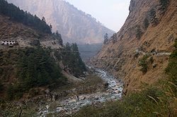
The river then flows southward through a steep gorge known as the Kali Gandaki Gorge
, or Andha Galchi, between the mountains Dhaulagiri
(8167 m) to the west and Annapurna I
(8091 m) to the east. If one measures the depth of a canyon by the difference between the river height and the heights of the highest peaks on either side, this gorge is the world's deepest. The portion of the river directly between Dhaulagiri and Annapurna I (7 km downstream from Tukuche
) is at an elevation of 2520 metres, 5571 metres lower than Annapurna I. The river is older than the Himalayas. As tectonic activity forces the mountains higher, the river has cut through the uplift.
South of the gorge, the river is joined by Rahughat Khola
at Galeshwor, Myagdi Khola at Beni, Modi Khola near Kushma and Badigaad at Rudrabeni above Ridi Bazaar. The river then turns east to run along the northern edge of the Mahabharat Range. The largest hydroelectricity
project in Nepal is located along this stretch of the river. Turning south again and breaking through the Mahabharats, Kali Gandaki is then joined by a major tributary, Trishuli at Devighat,The trisuli river is already mixed with five tibutaries named budugandaki,marshyandi,daraudi,seti and madi, then by the (East) Rapti draining the Inner Terai valley
known as Chitwan
. The Gandaki then crosses the outermost foothills of the Himalayas—Sivalik Hills—into the Terai plains of Nepal. From Devighat, the river flows southwest and is known as Narayani
or Sapt Gandaki. The river later curves back towards the southeast as it enters India where it is called the Gandak.
state through Champaran, Gopalganj, Saran and Muzaffarpur districts. It joins the Ganges near Patna
just downstream of Hajipur at Sonepur (also known as Harihar Kshetra). Its drainage area in India is 7620 km2.
From its exit from the outermost Siwaliks foothills to the Ganges, the Gandak has built an immense megafan
comprising Eastern Uttar Pradesh and North Western Bihar in the Middle Gangetic Plains. The megafan consists of sediments eroded from the rapidly-uplifting Himalaya. The river's course over this structure is constantly shifting. It is said that the river has shifted 80 km to the east due to tectonic tilting in the last 5,000 years.
Glacier lakes, among the most hazardous features of high mountains, are usually formed behind dams of moraine debris left behind by retreating glaciers, a trend that is observed all over the world. Even though glacial lake outburst flood
(GLOF) events have been occurring in Nepal for many decades, the Dig Tsho glacier outburst, which took place in 1985, has triggered detailed study of this phenomenon. In 1996, the Water and Energy Commission Secretariat (WECS) of Nepal reported that five lakes were potentially dangerous, namely, Dig Tsho, Imja
, Lower Barun, Tsho Rolpa
, and Thulagi, all lying above 4100 metres (13,451.4 ft). A recent study done by ICIMOD and UNEP (UNEP, 2001) reported 27 potentially dangerous lakes in Nepal. In ten of them GLOF events have occurred in the past few years and some have been regenerating after the event.
, Frankfurt, the BGR (Federal Institute for Geosciences and Natural Resources, Germany), in cooperation with the Department of Hydrology and Meteorology in Kathmandu, have carried out studies on the Thulagi Glacier and have concluded that even assuming the worst case, a disastrous outburst of the lake can be excluded in the near future.
, Jomsom
, Beni
, Baglung
, Kusma
, Ridi, Devghat
, Narayangarh, Valmikinagar and Triveni. The river also forms the western border of Chitwan National Park. Gorkha is an important town in the Trisuli river basin. Along the stretch in Nepal, the river carries heavy amounts of glacial silt, imparting the river a black color. Kali Gandaki, Marshyandi,Seti,is a popular whitewater adventure destination.
 The important towns in the Indian part of the Gandak river are the Valmikinagar(Bhainsalotan)- location of Gandak Barrage, Bagaha
, Bettia (district hqrs & field directorate of Valmiki Tiger Project), Harinagar (Ramnagar), Hajipur
(across the Ganges 10 km from Patna) and Sonepur (also Known as Harihar Kshetra), near Patna.
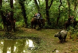
. The park is rich in flora and fauna, including Bengal Tigers and one of the last populations of single-horned Indian Rhinoceros (Rhinoceros unicornis). The area used to be known as the Chitwan Valley. It was a place for big game hunting and until 1951 it was a hunting reserve. At the park there is canoeing, elephant rides, and guided jungle walks.
The notable species of Wild Fauna include: Tiger, Leopard, Wild dog" Wild boar, Bison,Bear, Peacock, Partridge, Hornbill, Hill mynah,Woolly-necked stork, python, Crocodile, Deer,Sambar, Blue bull, Barking deer, Hog deer.
As per the Botanical Survey of India report 1998 there are seven types of vegetation consisting of seven classes of forests; home to 84 species of trees (subtropical trees such as Sal, Sagwan, Bamboo, Cane, etc.), 32 shrubs and climbers and 81 herbs and grasses.
Ashram (hermitage) and surrounding temples are located in the Chitwan National Park of Nepal.It is located at a distanace of about 7 km from Valmikinagar. It is approachable for pilgrimage only from Valmikinagar near Gandak Barrage, both from Nepal and India.
It is said that Valmiki Rishi (sage) wrote the great epic, "Ramayana
" here. It is also believed to be the birthplace of Luv & Kush (the two sons of Lord Ram
and his divine wife Sita
. The hermitage also has landmarks of Sita
’s ‘Falahar’ (eating place), Meditation place of the great Sage-Valmiki, the place where the Ashwamedh horse was tied, Amrit
(nectar of immortality) Kuan (well); Vishnu
Chakra (disc), and the Hawan (Yagna) Kund
(sacred square structure to perform fire rituals).
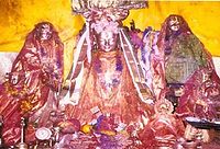
In the periphery of 3 to 4 km (1.9 to 2.5 ) around the Valmiki Ashram, the temples of importance are a) the Jatashankar (Shiv
) Temple, 2) Nardevi (Sweta Kali
)Temple (Form of Durga
and 3) Kaleshwaran (an avatar of the God Shiva) Temple. Triveni Temple is located across the Gandak Barrage in Nepal, about 3 km from the Gandak Barrage.
fossils) collected from the bed of the Gandaki River at a place close to Saligrama or Muktinath
(literally meaning "place of salvation") in the Mustang district of Nepal, (where a Hindu shrine of the Shrivaishnava sect founded by the great seer Ramanuja
exists) are called Saligram Silas and considered unique and are used for worship. It is also a sacred place for Buddhists who call it Chumig Gyatsa
, which in Tibetan
means 'Hundred Waters'..Muktinath
is also called by the Hindus as Mukthiksehtra, which literally means "place of salvation".
These stones are naturally formed round stones, with circular or spiral markings and are fossil ammonite stones found in the rivers of Himalayas, in particular kinds of ocean sediments, which have been uplifted to the top of the Himalayas.
Located between the Dhaulagiri
and Annapurna
mountain ranges, the Gandaki River flows through the village of Saligrama or Muktinath and the Ashrama of Pulaha. In ancient times, the mountain range surrounding Pulaha was called Salagiris due to the vast forests of Sala (sal) trees. The stones found in this region are therefore called Saligrama – Silas (stones found only in the region of Saligrama. It has great significance to Hindus, particularly to the Shrivaishnava and the Madhva
Sects who consider the place of availability of this stone in the river bed of the Gandaki River, and the Mukthinath temple as one of the 108 Divyakshetrams or Thirthastanas (temples and celestial abodes of Vishnu
) to be visited on a pilgrimage (at least once in their life). At the pilgrimage site of Muktinath (3,710m) one wonders in amazement at the presence of 108 small waterfalls and mysterious natural gas fires, worshipped as Jwalamukhi (in Sanskrit).
 For Tibetan Buddhists Muktinath-Chumig Gyatsa is a place of Dakini
s, goddesses known as Sky Dancers. It is of great importance for Buddhists that Chumig Gyatsa is one of the 24 Tantric
places.
The Tibetan Buddhist tradition states that for this reason Guru Rinpoche, also known as Padmasambhava
, the founder of Tibetan Buddhism
had meditated at Muktinath on his way to Tibet. It is one of the 51 Sakthi peetams.
The particular site in the course of the river where the stones become sacred is known as Chakra-Tirtha. The sanctity of this site is said to extend to three yojanas (24 miles) all round.
There is also a tributary called Chakra-nadi or Jhong Khola which flows from Muktinath and joins the Kali Gandaki at Kagbeni. This tributary is described in Garuda purana as created by Brahma
; and the great peak to the north of the river is said to contain the presence of Vishnu. All the stones found in the river as well as in the mountain are believed to bear the marks of Vishnu. The entire area (including streams and the mountainside to the north of Muktinath) covers as many as twelve yojanas (96 miles), according to the Puranic account. Among the Saligrama stones, some are from the waters (jalaja) and some are from the mountainside (sthalaja). Puranic texts testify that the sacred stones are what are found in the river, and not what are taken out of the rock on its banks.
made in the late medieval period (18th century), by one of the army commanders of Nepal. The temple brings-in a fresh pagoda-style architecture of the Himalayan Kingdom to the plains of the Ganges. This temple is built largely of wood. Another distinctive feature of this temple is its fine wooden carving, which includes, of others, generous erotic scenes.
Vaishali, which was the capital of one of the states in northern India during Buddha's lifetime, to Nalanda, which was the seat of a celebrated Buddhist monastic university in the 5th–12th century.
In Lauria block, about 1 km east of Nandan Garh, a lion pillar of Ashoka, made out of a single block of polished sand stone, measuring 35 feet (10.7 m) in height with a diameter of 35" at the base and 22" at the top, which is believed to be over 2,300 years old, is in an excellent condition. Its massiveness and exquisite finish furnish striking proof of the skill and resources of the masons of Ashokan age. Two more such pillars with their capitals removed have been discovered in Rampurwa village, close to Gandhi's Bhitiharawa Ashram in Gaunaha block. One of their capitals, the bull is now in the National Museum at New Delhi and the other, the lion, is at Calcutta Museum.
At Nandan Garh there are also Baudh (Buddha
) stupas made out of bricks and about 80 feet (24.4 m) high which according to the authoritative source are Ashoka Stupas, in which ashes of Lord Buddha’s funeral pyre are enshrined.
Someshwar Fort is situated in Narkatiaganj sub-division, near Nepal border, on top of Someshwar Hill at 2884 ft (879 m) altitude. It is in a ruined state but its remains are well defined.
The Bhitiharawa Ashram of Mahatma Gandhi
near Gaunaha in the eastern end of the Valmiki reserve. It is a village in Gaunaha block in Bihar from where Gandhiji started his freedom movement that came to be known as 'Champaran Satyagraha' in India history. The village houses the hut which is called Ashram and has become a place of Gandhian pilgrimage.
A major Indian firm has entered into a share purchase and joint venture agreement with a Nepalese firm to acquire 80 per cent stake of Nepalese Company for development of the Upper Marsyangdi HEP (250MW). Achieving the economically exploitable potential need would no more be a mirage.
Reportedly there are several other major projects being pursued by the Government of Nepal for private sector participation on IPP basis.
A hydroelectric generating station with an installed capacity of 15 MW (3x5 MW) has also been constructed and commissioned on the by pass to Eastern Gandak Canal.
Nepal
Nepal , officially the Federal Democratic Republic of Nepal, is a landlocked sovereign state located in South Asia. It is located in the Himalayas and bordered to the north by the People's Republic of China, and to the south, east, and west by the Republic of India...
and the Gandak in India
India
India , officially the Republic of India , is a country in South Asia. It is the seventh-largest country by geographical area, the second-most populous country with over 1.2 billion people, and the most populous democracy in the world...
) is one of the major rivers of Nepal and a left bank tributary of the Ganges in India It is also called Krishna Gandaki in Nepal. In Nepal the river is notable for its deep gorge
Canyon
A canyon or gorge is a deep ravine between cliffs often carved from the landscape by a river. Rivers have a natural tendency to reach a baseline elevation, which is the same elevation as the body of water it will eventually drain into. This forms a canyon. Most canyons were formed by a process of...
through the Himalayas
Himalayas
The Himalaya Range or Himalaya Mountains Sanskrit: Devanagari: हिमालय, literally "abode of snow"), usually called the Himalayas or Himalaya for short, is a mountain range in Asia, separating the Indian subcontinent from the Tibetan Plateau...
and its enormous hydroelectric potential. It has a total catchment area of 46300 square kilometres (17,876.5 sq mi), most of it in Nepal. The basin also contains 3 of the world's 14 highest mountains over 8,000m, the three being Dhaulagiri I
Dhaulagiri
Dhaulagiri is Earth's seventh highest mountain at ; one of fourteen over eight thousand metres. Dhaulagiri was first climbed May 13, 1960 by a Swiss/Austrian expedition....
, Manaslu
Manaslu
Manaslu , also known as Kutang) is the eighth highest mountain in the world, and is located in the Mansiri Himal, part of the Nepalese Himalayas, in the west-central part of Nepal. Its name, which means "Mountain of the Spirit", comes from the Sanskrit word Manasa, meaning "intellect" or "soul"...
and Annapurna I
Annapurna
Annapurna is a section of the Himalayas in north-central Nepal that includes Annapurna I, thirteen additional peaks over and 16 more over ....
. Dhaulagiri I
Dhaulagiri
Dhaulagiri is Earth's seventh highest mountain at ; one of fourteen over eight thousand metres. Dhaulagiri was first climbed May 13, 1960 by a Swiss/Austrian expedition....
is the highest point of the Gandaki basin. It lies between the similar Kosi system to the east and the Karnali
Ghaghara River
Karnali or Ghaghara is a perennial trans-boundary river originating on the Tibetan Plateau near Lake Mansarovar. It cuts through the Himalayas in Nepal and joins the Sarda River at Brahmaghat in India. Together they form the Ghaghra River, a major left bank tributary of the Ganges. With a length of...
(Ghaghara) system to the west.
Nepal
The river is called Sapta (seven) Gandaki for seven tributaries rising in the Himalaya or further north along the main GangesGanges River
The Ganges or Ganga, , is a trans-boundary river of India and Bangladesh. The river rises in the western Himalayas in the Indian state of Uttarakhand, and flows south and east through the Gangetic Plain of North India into Bangladesh, where it empties into the Bay of Bengal. By discharge it...
-Brahmaputra
Brahmaputra River
The Brahmaputra , also called Tsangpo-Brahmaputra, is a trans-boundary river and one of the major rivers of Asia. It is the only Indian river that is attributed the masculine gender and thus referred to as a in Indo-Aryan languages and languages with Indo-Aryan influence...
divide. These are called Daraudi, Seti, Madi, Kali
Kali Gandaki Gorge
The Kali Gandaki Gorge or Andha Galchi is the gorge of the Kali Gandaki in the Himalayas in Nepal, by some measures the deepest gorge in the world....
, Marsyandi, Budhi, and Trisuli
Trishuli River
The Trishuli River is a trans-boundary river and is one of the major tributaries of the Narayani River basin in central Nepal. It originates in Tibet Autonomous Region of China where it is called Kyirong Tsangpo...
.
The Kali Gandaki river source is at the border with Tibet
Tibet
Tibet is a plateau region in Asia, north-east of the Himalayas. It is the traditional homeland of the Tibetan people as well as some other ethnic groups such as Monpas, Qiang, and Lhobas, and is now also inhabited by considerable numbers of Han and Hui people...
at an altitude of 6268 m (20,564.3 ft) at the Nhubine Himal Glacier in the Mustang
Mustang (kingdom)
Mustang is the former Kingdom of Lo and now part of Nepal, in the north-central part of that country, bordering the People's Republic of China on the Tibetan plateau between the Nepalese provinces of Dolpo and Manang...
region of Nepal.
The headwaters stream on some maps is named the Chhuama Khola and then, nearing Lo Manthang
Lo Manthang
Lo Manthang is a medieval walled city and Village Development Committee in Mustang District in the Dhawalagiri Zone of northern Nepal. At the time of the 1991 Nepal census it had a population of 876 people living in 178 individual households....
, the Nhichung Khola or Choro Khola. The Kali Gandaki then flows southwest (with the name of Mustang Khola on old, outdated maps) through a sheer-sided, deep canyon before widening at the steel footbridge at Chele, where part of its flow funnels through a rock tunnel, and from this point the now wide river is called the Kali Gandaki on all maps. In Kagbeni
Kagbeni, Mustang
Kagbeni is a village in Upper Mustang, Nepal, located in the valley of the Kali Gandaki River. Administratively, Kagbeni is a Village Development Committee in Mustang District in the Dhawalagiri Zone of northern Nepal. At the time of the 1991 Nepal census it had a population of 1200 people...
a major tributary named Johng Khola or Kak Khola descends from Muktinath
Muktinath
Muktinath is a sacred place both for Hindus and Buddhists located in Muktinath Valley at an altitude of 3,710 meters at the foot of the Thorong La mountain pass , Mustang district, Nepal...
.
The river then flows southward through a steep gorge known as the Kali Gandaki Gorge
Kali Gandaki Gorge
The Kali Gandaki Gorge or Andha Galchi is the gorge of the Kali Gandaki in the Himalayas in Nepal, by some measures the deepest gorge in the world....
, or Andha Galchi, between the mountains Dhaulagiri
Dhaulagiri
Dhaulagiri is Earth's seventh highest mountain at ; one of fourteen over eight thousand metres. Dhaulagiri was first climbed May 13, 1960 by a Swiss/Austrian expedition....
(8167 m) to the west and Annapurna I
Annapurna
Annapurna is a section of the Himalayas in north-central Nepal that includes Annapurna I, thirteen additional peaks over and 16 more over ....
(8091 m) to the east. If one measures the depth of a canyon by the difference between the river height and the heights of the highest peaks on either side, this gorge is the world's deepest. The portion of the river directly between Dhaulagiri and Annapurna I (7 km downstream from Tukuche
Tukuche
Tukuche , sometimes spelt Tukche, is a village development committee in Mustang District in the Dhawalagiri Zone of northern Nepal. At the time of the 1991 Nepal census it had a population of 652 people living in 166 individual households....
) is at an elevation of 2520 metres, 5571 metres lower than Annapurna I. The river is older than the Himalayas. As tectonic activity forces the mountains higher, the river has cut through the uplift.
South of the gorge, the river is joined by Rahughat Khola
Rahughat Khola
The Rahughat Khola is a tributary of the Krishna Gandaki River in Nepal.-Course:The stream originates from several glaciers and snowfields on the south face of Dhaulagiri and flows southwest in its open glacial valley among old moraines, alpine pastures and sub-alpine forests...
at Galeshwor, Myagdi Khola at Beni, Modi Khola near Kushma and Badigaad at Rudrabeni above Ridi Bazaar. The river then turns east to run along the northern edge of the Mahabharat Range. The largest hydroelectricity
Hydroelectricity
Hydroelectricity is the term referring to electricity generated by hydropower; the production of electrical power through the use of the gravitational force of falling or flowing water. It is the most widely used form of renewable energy...
project in Nepal is located along this stretch of the river. Turning south again and breaking through the Mahabharats, Kali Gandaki is then joined by a major tributary, Trishuli at Devighat,The trisuli river is already mixed with five tibutaries named budugandaki,marshyandi,daraudi,seti and madi, then by the (East) Rapti draining the Inner Terai valley
Inner Terai Valleys of Nepal
The Inner Terai Valleys or Bhitri tarai are various elongated valleys in Nepal situated between the Himalayan foothills, the 600–900 m high Siwalik or Churia Range and the 2,000-3,000 m high Mahabharat Range further north. Major examples are the Chitwan Valley southwest of Kathmandu and the...
known as Chitwan
Chitwan Valley
Chitwan Valley is an Inner Terai valley in the south of Nepal, encompassing the districts of Makwanpur, Chitwan and Nawalparasi. The valley is part of the Terai-Duar savanna and grasslands ecoregion of about 150 km length and 30–48 km width....
. The Gandaki then crosses the outermost foothills of the Himalayas—Sivalik Hills—into the Terai plains of Nepal. From Devighat, the river flows southwest and is known as Narayani
Narayani
Narayani may refer to:* Narayani River, Nepalese name for the Gandaki River* Narayani Zone, one of fourteen administrative zones in Nepal* Narayani , Hindu Goddess...
or Sapt Gandaki. The river later curves back towards the southeast as it enters India where it is called the Gandak.
India
The entry point of the river at the Indo-Nepal border is also the confluence called Triveni with rivers Pachnad and Sonha descending from Nepal. Pandai river flows into Bihar (India) from Nepal in the eastern end of the Valmiki Sanctuary and meets Masan. The Gandak flows southeast 300 km across the Gangetic plain of BiharBihar
Bihar is a state in eastern India. It is the 12th largest state in terms of geographical size at and 3rd largest by population. Almost 58% of Biharis are below the age of 25, which is the highest proportion in India....
state through Champaran, Gopalganj, Saran and Muzaffarpur districts. It joins the Ganges near Patna
Patna
Paṭnā , is the capital of the Indian state of Bihar and the second largest city in Eastern India . Patna is one of the oldest continuously inhabited places in the world...
just downstream of Hajipur at Sonepur (also known as Harihar Kshetra). Its drainage area in India is 7620 km2.
From its exit from the outermost Siwaliks foothills to the Ganges, the Gandak has built an immense megafan
Alluvial fan
An alluvial fan is a fan-shaped deposit formed where a fast flowing stream flattens, slows, and spreads typically at the exit of a canyon onto a flatter plain. A convergence of neighboring alluvial fans into a single apron of deposits against a slope is called a bajada, or compound alluvial...
comprising Eastern Uttar Pradesh and North Western Bihar in the Middle Gangetic Plains. The megafan consists of sediments eroded from the rapidly-uplifting Himalaya. The river's course over this structure is constantly shifting. It is said that the river has shifted 80 km to the east due to tectonic tilting in the last 5,000 years.
Glaciers, glacial lakes and glacial lake outburst floods
The Gandaki river basin is reported to contain 1025 glaciers and 338 lakes. These contribute substantially to the lean season flows of the river.Glacier lakes, among the most hazardous features of high mountains, are usually formed behind dams of moraine debris left behind by retreating glaciers, a trend that is observed all over the world. Even though glacial lake outburst flood
Glacial lake outburst flood
A glacial lake outburst flood is a type of outburst flood that occurs when the dam containing a glacial lake fails. The dam can consist of glacier ice or a terminal moraine...
(GLOF) events have been occurring in Nepal for many decades, the Dig Tsho glacier outburst, which took place in 1985, has triggered detailed study of this phenomenon. In 1996, the Water and Energy Commission Secretariat (WECS) of Nepal reported that five lakes were potentially dangerous, namely, Dig Tsho, Imja
Imja Tsho, Nepal
Imja Tsho is a glacial lake created after melt water began collecting at the foot of the Imja Glacier in the 1960s. A 2009 study described this lake of melt water as one of the fastest-growing in the Himalaya...
, Lower Barun, Tsho Rolpa
Tsho Rolpa
Tsho Rolpa is one of the biggest glacial lakes in Nepal. The lake, which is located at an altitude of 4,580 metres in the Dolakha District, has grown considerably over the last 50 years due to glacial melting in the Himalayas...
, and Thulagi, all lying above 4100 metres (13,451.4 ft). A recent study done by ICIMOD and UNEP (UNEP, 2001) reported 27 potentially dangerous lakes in Nepal. In ten of them GLOF events have occurred in the past few years and some have been regenerating after the event.
Thulagi glacier
The Thulagi glacier, which is located in the Upper Marsyangdi River basin, is one out of the two moraine-dammed lakes (supra-glacial lakes), identified as a potentially dangerous lake. The KfWKreditanstalt für Wiederaufbau
KfW banking group is a German government-owned development bank, based in Frankfurt. Its name originally comes from Kreditanstalt für Wiederaufbau, meaning Reconstruction Credit Institute. It was formed in 1948 after World War II as part of the Marshall Plan.It is owned by the Federal Republic of...
, Frankfurt, the BGR (Federal Institute for Geosciences and Natural Resources, Germany), in cooperation with the Department of Hydrology and Meteorology in Kathmandu, have carried out studies on the Thulagi Glacier and have concluded that even assuming the worst case, a disastrous outburst of the lake can be excluded in the near future.
Important towns
Major towns and cities located along or near the banks of the Kali Gandaki are Lo ManthangLo Manthang
Lo Manthang is a medieval walled city and Village Development Committee in Mustang District in the Dhawalagiri Zone of northern Nepal. At the time of the 1991 Nepal census it had a population of 876 people living in 178 individual households....
, Jomsom
Jomsom
Jomsom , also known as Dzongsam or New Fort, is a town located at an altitude of 2800m in Mustang, Nepal. It extends over both the banks of the Kali Gandaki River. Along the banks of Kali Gandaki river there are rocks holy to the Hindus. The soaring peaks of Dhaulagiri and Nilgiri form a backdrop...
, Beni
Beni, Nepal
Beni is the district headquarters of Myagdi District in Dhawalagiri Zone, Nepal. It is located on the confluence of Kali River and Myagdi river at an altitude of 899 metres. It is the northernmost of the Tri-cities area of Nepal. It is located 12 km to the north of Zonal headquarters Baglung...
, Baglung
Baglung
Baglung, is a town in western Nepal, 275 km west of Kathmandu. It is the administrative headquarters of Baglung District and Dhawalagiri Zone. Baglung is a major business, financial, educational, and healthcare center for the people of Kali Gandaki valley....
, Kusma
Kusma, Nepal
Kusma is the headquarter of Parbat District, one of a district among 75 districts in Nepal, which lies in the western part of Nepal just about 57 Km away from one of a famous city of Nepal, Pokhara. Kusma falls under Western Development Region and Dhaoolagiri Zone of Nepal.It is located at...
, Ridi, Devghat
Devghat
Devghat is a town located at the junction of the Sapta Gandaki and Krishna Gandaki rivers in Central Nepal, and is one of the holiest places in Hindu mythology as well as a holy place for Hindu gods...
, Narayangarh, Valmikinagar and Triveni. The river also forms the western border of Chitwan National Park. Gorkha is an important town in the Trisuli river basin. Along the stretch in Nepal, the river carries heavy amounts of glacial silt, imparting the river a black color. Kali Gandaki, Marshyandi,Seti,is a popular whitewater adventure destination.
Bagaha
Bagaha is a city and a municipality in Pashchim Champaran district in the state of Bihar, India.-Geography:Bagaha is located at . It has an average elevation of 135 metres .-Demographics:...
, Bettia (district hqrs & field directorate of Valmiki Tiger Project), Harinagar (Ramnagar), Hajipur
Hajipur
Hajipur is the headquarters of Vaishali district in the Indian state of Bihar. It is famous for producing bananas, and has a modern railway zonal office. Patna, the capital of Bihar is only 10 km from Hajipur...
(across the Ganges 10 km from Patna) and Sonepur (also Known as Harihar Kshetra), near Patna.
In traditional and popular culture
- The Gandaki river is mentioned in the ancient SanskritSanskritSanskrit , is a historical Indo-Aryan language and the primary liturgical language of Hinduism, Jainism and Buddhism.Buddhism: besides Pali, see Buddhist Hybrid Sanskrit Today, it is listed as one of the 22 scheduled languages of India and is an official language of the state of Uttarakhand...
epic MahabharataMahabharataThe Mahabharata is one of the two major Sanskrit epics of ancient India and Nepal, the other being the Ramayana. The epic is part of itihasa....
. - Episode 1 of "The Living PlanetThe Living PlanetThe Living Planet: A Portrait of the Earth is a BBC nature documentary series written and presented by David Attenborough, first transmitted in the UK from 19 January 1984....
," David AttenboroughDavid AttenboroughSir David Frederick Attenborough OM, CH, CVO, CBE, FRS, FZS, FSA is a British broadcaster and naturalist. His career as the face and voice of natural history programmes has endured for more than 50 years...
's second nature documentary series, is set in the Kali Gandaki Gorge.
National Parks
Chitwan National Park of Nepal and Valmiki National Park of India are adjacent to each other in the vicinity of Valmikinagar around the Gandak Barrage.Chitwan National Park
Chitwan National Park covers an area of 932 km² and is the oldest national park of Nepal established in 1973. It was granted the status of a World Heritage Site in 1984. It is located in Chitwan, one of the Inner Terai Valleys of NepalInner Terai Valleys of Nepal
The Inner Terai Valleys or Bhitri tarai are various elongated valleys in Nepal situated between the Himalayan foothills, the 600–900 m high Siwalik or Churia Range and the 2,000-3,000 m high Mahabharat Range further north. Major examples are the Chitwan Valley southwest of Kathmandu and the...
. The park is rich in flora and fauna, including Bengal Tigers and one of the last populations of single-horned Indian Rhinoceros (Rhinoceros unicornis). The area used to be known as the Chitwan Valley. It was a place for big game hunting and until 1951 it was a hunting reserve. At the park there is canoeing, elephant rides, and guided jungle walks.
Valmiki National Park
Valmiki sanctuary covers about 800 km² of forest and is the 18th Tiger Reserve[projecttiger.nic.in/valmiki.htm] of the country and ranked fourth in terms density of Tiger population. Valmikinagar is located nearly 100 km from Bettiah in the northernmost part of the West Champaran district, bordering Nepal. Valmikinagar is a small town with scattered habitation, mostly within the forest area and has a railroad station in the district of West Champaran, close to the railhead of Narkatiaganj.It has diverse landscapes, sheltering rich wildlife habitats and floral and faunal composition with the prime protected carnivores and was included in the National Conservation Programme of the Project Tiger in the year 1994.As per Zoological Survey of India's report of 1998 the Sanctuary is reported to shelter 53 mammals, 145 birds, 26 reptile & 13 amphibians. and Tiger ReserveThe notable species of Wild Fauna include: Tiger, Leopard, Wild dog" Wild boar, Bison,Bear, Peacock, Partridge, Hornbill, Hill mynah,Woolly-necked stork, python, Crocodile, Deer,Sambar, Blue bull, Barking deer, Hog deer.
As per the Botanical Survey of India report 1998 there are seven types of vegetation consisting of seven classes of forests; home to 84 species of trees (subtropical trees such as Sal, Sagwan, Bamboo, Cane, etc.), 32 shrubs and climbers and 81 herbs and grasses.
Valmiki Ashram
The ancient ValmikiValmiki
Valmiki is celebrated as the poet harbinger in Sanskrit literature. He is the author of the epic Ramayana, based on the attribution in the text of the epic itself. He is revered as the Adi Kavi, which means First Poet, for he discovered the first śloka i.e...
Ashram (hermitage) and surrounding temples are located in the Chitwan National Park of Nepal.It is located at a distanace of about 7 km from Valmikinagar. It is approachable for pilgrimage only from Valmikinagar near Gandak Barrage, both from Nepal and India.
It is said that Valmiki Rishi (sage) wrote the great epic, "Ramayana
Ramayana
The Ramayana is an ancient Sanskrit epic. It is ascribed to the Hindu sage Valmiki and forms an important part of the Hindu canon , considered to be itihāsa. The Ramayana is one of the two great epics of India and Nepal, the other being the Mahabharata...
" here. It is also believed to be the birthplace of Luv & Kush (the two sons of Lord Ram
Rama
Rama or full name Ramachandra is considered to be the seventh avatar of Vishnu in Hinduism, and a king of Ayodhya in ancient Indian...
and his divine wife Sita
SITA
SITA is a multinational information technology company specialising in providing IT and telecommunication services to the air transport industry...
. The hermitage also has landmarks of Sita
SITA
SITA is a multinational information technology company specialising in providing IT and telecommunication services to the air transport industry...
’s ‘Falahar’ (eating place), Meditation place of the great Sage-Valmiki, the place where the Ashwamedh horse was tied, Amrit
Amrit
Amrit, also known as Marathos or Marathus, was an ancient city located near Tartous in Syria. It was founded during the Amorites period, 3rd millennium BC....
(nectar of immortality) Kuan (well); Vishnu
Vishnu
Vishnu is the Supreme god in the Vaishnavite tradition of Hinduism. Smarta followers of Adi Shankara, among others, venerate Vishnu as one of the five primary forms of God....
Chakra (disc), and the Hawan (Yagna) Kund
Kund
Kund is a village and one of the 51 Union Councils of Khushab District in the Punjab Province of Pakistan. It is located at 32°24'40N 72°12'17E.-Location:...
(sacred square structure to perform fire rituals).
In the periphery of 3 to 4 km (1.9 to 2.5 ) around the Valmiki Ashram, the temples of importance are a) the Jatashankar (Shiv
Shiv
The word Shiv or shiv may refer to:* Shiv , a type of sharp weapon* Shiva, a Hindu deity* A fictional location in Magic: The Gathering, see Dominaria* Shiv, a villain in the animated series Static Shock...
) Temple, 2) Nardevi (Sweta Kali
Kali
' , also known as ' , is the Hindu goddess associated with power, shakti. The name Kali comes from kāla, which means black, time, death, lord of death, Shiva. Kali means "the black one". Since Shiva is called Kāla - the eternal time, Kālī, his consort, also means "Time" or "Death" . Hence, Kāli is...
)Temple (Form of Durga
Durga
For the 1985 Hindi Film of Rajesh Khanna see DurgaaIn Hinduism, Durga ; ; meaning "the inaccessible" or "the invincible"; , durga) or Maa Durga "one who can redeem in situations of utmost distress" is a form of Devi, the supremely radiant goddess, depicted as having eighteen arms, riding a lion...
and 3) Kaleshwaran (an avatar of the God Shiva) Temple. Triveni Temple is located across the Gandak Barrage in Nepal, about 3 km from the Gandak Barrage.
Saligrama Sila and Mukthinath
The stones (AmmoniteAmmonite
Ammonite, as a zoological or paleontological term, refers to any member of the Ammonoidea an extinct subclass within the Molluscan class Cephalopoda which are more closely related to living coleoids Ammonite, as a zoological or paleontological term, refers to any member of the Ammonoidea an extinct...
fossils) collected from the bed of the Gandaki River at a place close to Saligrama or Muktinath
Muktinath
Muktinath is a sacred place both for Hindus and Buddhists located in Muktinath Valley at an altitude of 3,710 meters at the foot of the Thorong La mountain pass , Mustang district, Nepal...
(literally meaning "place of salvation") in the Mustang district of Nepal, (where a Hindu shrine of the Shrivaishnava sect founded by the great seer Ramanuja
Ramanuja
Ramanuja ; traditionally 1017–1137, also known as Ramanujacharya, Ethirajar , Emperumannar, Lakshmana Muni, was a theologian, philosopher, and scriptural exegete...
exists) are called Saligram Silas and considered unique and are used for worship. It is also a sacred place for Buddhists who call it Chumig Gyatsa
Chumig Gyatsa
Chumig Gyatsa is one of the 24 Buddhist Tantric places.Chumig Gyatsa means 'Hundred Waters' in Tibetan.It is the local name for the pilgrimage site Muktinath, a sacred place both for Hindus as well as the Buddhists, located at an altitude of 3,710 meters, at the foot of the Thorung La mountain...
, which in Tibetan
Tibetan language
The Tibetan languages are a cluster of mutually-unintelligible Tibeto-Burman languages spoken primarily by Tibetan peoples who live across a wide area of eastern Central Asia bordering the Indian subcontinent, including the Tibetan Plateau and the northern Indian subcontinent in Baltistan, Ladakh,...
means 'Hundred Waters'..Muktinath
Muktinath
Muktinath is a sacred place both for Hindus and Buddhists located in Muktinath Valley at an altitude of 3,710 meters at the foot of the Thorong La mountain pass , Mustang district, Nepal...
is also called by the Hindus as Mukthiksehtra, which literally means "place of salvation".
These stones are naturally formed round stones, with circular or spiral markings and are fossil ammonite stones found in the rivers of Himalayas, in particular kinds of ocean sediments, which have been uplifted to the top of the Himalayas.
Located between the Dhaulagiri
Dhaulagiri
Dhaulagiri is Earth's seventh highest mountain at ; one of fourteen over eight thousand metres. Dhaulagiri was first climbed May 13, 1960 by a Swiss/Austrian expedition....
and Annapurna
Annapurna
Annapurna is a section of the Himalayas in north-central Nepal that includes Annapurna I, thirteen additional peaks over and 16 more over ....
mountain ranges, the Gandaki River flows through the village of Saligrama or Muktinath and the Ashrama of Pulaha. In ancient times, the mountain range surrounding Pulaha was called Salagiris due to the vast forests of Sala (sal) trees. The stones found in this region are therefore called Saligrama – Silas (stones found only in the region of Saligrama. It has great significance to Hindus, particularly to the Shrivaishnava and the Madhva
Madhvacharya
Madhvācārya was the chief proponent of Tattvavāda "Philosophy of Reality", popularly known as the Dvaita school of Hindu philosophy. It is one of the three most influential Vedānta philosophies. Madhvācārya was one of the important philosophers during the Bhakti movement. He was a pioneer in...
Sects who consider the place of availability of this stone in the river bed of the Gandaki River, and the Mukthinath temple as one of the 108 Divyakshetrams or Thirthastanas (temples and celestial abodes of Vishnu
Vishnu
Vishnu is the Supreme god in the Vaishnavite tradition of Hinduism. Smarta followers of Adi Shankara, among others, venerate Vishnu as one of the five primary forms of God....
) to be visited on a pilgrimage (at least once in their life). At the pilgrimage site of Muktinath (3,710m) one wonders in amazement at the presence of 108 small waterfalls and mysterious natural gas fires, worshipped as Jwalamukhi (in Sanskrit).
Dakini
A dakini is a tantric deity described as a female embodiment of enlightened energy. In the Tibetan language, dakini is rendered khandroma which means 'she who traverses the sky' or 'she who moves in space'. Sometimes the term is translated poetically as 'sky dancer' or 'sky walker'. The dakini, in...
s, goddesses known as Sky Dancers. It is of great importance for Buddhists that Chumig Gyatsa is one of the 24 Tantric
Vajrayana
Vajrayāna Buddhism is also known as Tantric Buddhism, Tantrayāna, Mantrayāna, Secret Mantra, Esoteric Buddhism and the Diamond Vehicle...
places.
The Tibetan Buddhist tradition states that for this reason Guru Rinpoche, also known as Padmasambhava
Padmasambhava
Padmasambhava ; Mongolian ловон Бадмажунай, lovon Badmajunai, , Means The Lotus-Born, was a sage guru from Oddiyāna who is said to have transmitted Vajrayana Buddhism to Bhutan and Tibet and neighbouring countries in the 8th century...
, the founder of Tibetan Buddhism
Tibetan Buddhism
Tibetan Buddhism is the body of Buddhist religious doctrine and institutions characteristic of Tibet and certain regions of the Himalayas, including northern Nepal, Bhutan, and India . It is the state religion of Bhutan...
had meditated at Muktinath on his way to Tibet. It is one of the 51 Sakthi peetams.
The particular site in the course of the river where the stones become sacred is known as Chakra-Tirtha. The sanctity of this site is said to extend to three yojanas (24 miles) all round.
There is also a tributary called Chakra-nadi or Jhong Khola which flows from Muktinath and joins the Kali Gandaki at Kagbeni. This tributary is described in Garuda purana as created by Brahma
Brahma
Brahma is the Hindu god of creation and one of the Trimurti, the others being Vishnu and Shiva. According to the Brahma Purana, he is the father of Mānu, and from Mānu all human beings are descended. In the Ramayana and the...
; and the great peak to the north of the river is said to contain the presence of Vishnu. All the stones found in the river as well as in the mountain are believed to bear the marks of Vishnu. The entire area (including streams and the mountainside to the north of Muktinath) covers as many as twelve yojanas (96 miles), according to the Puranic account. Among the Saligrama stones, some are from the waters (jalaja) and some are from the mountainside (sthalaja). Puranic texts testify that the sacred stones are what are found in the river, and not what are taken out of the rock on its banks.
Nepali Mandir, Hajipur
It is a unique Shaivite shrine near HajipurHajipur
Hajipur is the headquarters of Vaishali district in the Indian state of Bihar. It is famous for producing bananas, and has a modern railway zonal office. Patna, the capital of Bihar is only 10 km from Hajipur...
made in the late medieval period (18th century), by one of the army commanders of Nepal. The temple brings-in a fresh pagoda-style architecture of the Himalayan Kingdom to the plains of the Ganges. This temple is built largely of wood. Another distinctive feature of this temple is its fine wooden carving, which includes, of others, generous erotic scenes.
Jamia Masjid, Hajipur
This mosque in Hajipur, called Jami Masjid, built in 1587, is a plain building measuring 84.5 ft (25.8 m) long and 33.5 ft (10.2 m) broad, crowned by three domes, the central one being larger than the others.Vaishali, which was the capital of one of the states in northern India during Buddha's lifetime, to Nalanda, which was the seat of a celebrated Buddhist monastic university in the 5th–12th century.
Places of Archaeological significance
Archaeologically important places around Valmikinagar are Lauriya-Nandangarh and Someshwar Fort.In Lauria block, about 1 km east of Nandan Garh, a lion pillar of Ashoka, made out of a single block of polished sand stone, measuring 35 feet (10.7 m) in height with a diameter of 35" at the base and 22" at the top, which is believed to be over 2,300 years old, is in an excellent condition. Its massiveness and exquisite finish furnish striking proof of the skill and resources of the masons of Ashokan age. Two more such pillars with their capitals removed have been discovered in Rampurwa village, close to Gandhi's Bhitiharawa Ashram in Gaunaha block. One of their capitals, the bull is now in the National Museum at New Delhi and the other, the lion, is at Calcutta Museum.
At Nandan Garh there are also Baudh (Buddha
Gautama Buddha
Siddhārtha Gautama was a spiritual teacher from the Indian subcontinent, on whose teachings Buddhism was founded. In most Buddhist traditions, he is regarded as the Supreme Buddha Siddhārtha Gautama (Sanskrit: सिद्धार्थ गौतम; Pali: Siddhattha Gotama) was a spiritual teacher from the Indian...
) stupas made out of bricks and about 80 feet (24.4 m) high which according to the authoritative source are Ashoka Stupas, in which ashes of Lord Buddha’s funeral pyre are enshrined.
Someshwar Fort is situated in Narkatiaganj sub-division, near Nepal border, on top of Someshwar Hill at 2884 ft (879 m) altitude. It is in a ruined state but its remains are well defined.
The Bhitiharawa Ashram of Mahatma Gandhi
Mahatma Gandhi
Mohandas Karamchand Gandhi , pronounced . 2 October 1869 – 30 January 1948) was the pre-eminent political and ideological leader of India during the Indian independence movement...
near Gaunaha in the eastern end of the Valmiki reserve. It is a village in Gaunaha block in Bihar from where Gandhiji started his freedom movement that came to be known as 'Champaran Satyagraha' in India history. The village houses the hut which is called Ashram and has become a place of Gandhian pilgrimage.
Mustang Caves
A chance discovery by a villager of an extraordinary art treasure that lay hidden from the world for centuries was made in 2007 in a partially collapsed cave (at 3,400 m elevation) containing the 12th to 14th century collection of 55 exquisite cave paintings depicting the life of Buddha. Mr. Fieni, a member of a team of Italian, US and Nepalese conservators and archaeologists which has explored these findings, has said that "Finding the cave was almost like a miracle, --- Unlike the murals in the monastery, the Mustang cave paintings do not reveal a Tibetan but a strong Indian influence, including the animals they depict - leopard, tiger, monkey and deer," said. "In fact, the style evokes the fabulous cave paintings of Ajanta, which predate the Mustang caves by several centuries." The exploration team has called it "the snow leopard cave" as the animal's footprints were found inside. The simultaneous discovery of ancient Tibetan manuscripts in nearby caves has also led to speculation that the caves might have been a teaching retreat on the lines of the Buddhist university in Nalanda.Nepal
In Nepal, Sapta Gandaki alone has a huge hydropower potential of 20,650 MW (economic exploitable potential is 5,270 MW) out of a total estimated potential of 83,290 MW (economically exploitable potential is 42,140 MW). The country has so far been able to generate only around 600 MW of hydropower out of which the Gandak basin projects contribute more than 44% - 266 MW. The hydropower projects built are the Trisuli at Nuwakot (21 MW), Devighat at Nuwakot (14 MW), Pokhra (1MW) and Western Gandak HEP, at Nawalparasi (15) MW, financed by the Government of India, Marsyangdi at Tanahu (69 MW), Kali Gandaki at Syanja (144 MW), and Syange 2 MW. Middle Marsyangdi HE Project (70 MW) at Lamjung is under final stage of construction. Several major projects are on the anvil for implementation in the near future. With Government of Nepal now according priority to private-sector participation in a multi-pronged approach, the pace of hydropower development will get accelerated.A major Indian firm has entered into a share purchase and joint venture agreement with a Nepalese firm to acquire 80 per cent stake of Nepalese Company for development of the Upper Marsyangdi HEP (250MW). Achieving the economically exploitable potential need would no more be a mirage.
Reportedly there are several other major projects being pursued by the Government of Nepal for private sector participation on IPP basis.
India
The Gandak terrain in India is mostly flat plains, hence does not have any large hydropower potential. Only, a few small canal head power stations are envisaged.Irrigation development - Nepal and India
The Gandak Project at Valmikinagar (Bhainsaloton), intercepts water of a catchment (37,410 sqkm – 90% area is in Nepal) which lies partly in Nepal and partly in India. An Agreement between His Majesty’s Government of Nepal and the Government of India on the Gandak Irrigation and Power Project, signed at Kathmandu on 4 December 1959; which came in force upon signature (somewhat modified in 1964), to construct the project comprising a barrage, canal head regulators and other appurtenant works about 33 m (100 ft) below the existing Triveni Canal Head Regulator and of taking out canal systems for purposes development of irrigation and power for Nepal and India. Some modification was subsequently made in this agreement in 1964 for the protection of Nepal’s riparian rights. Basically there is an agreed share of water for ‘western Canal System including a power station in Nepal and Eastern canal System. As a part of this bilateral agreement, the Gandak Barrage, a part of Gandak Project, has been built (1968/69.) over the Gandak river for providing irrigation to Nepal, U.P. and Bihar. The irrigation potential of this project is 11,510 km², spread in the district of West Champaran, East Champaran, Muzaffarpur, Samastipur, Saran, Siwan & Gopalganj. The Eastern Gandak Canal Project was taken up in 1960 and Main Canal system was completed in 1975 for flow irrigation in Nepal for the gross commanded area estimated to be 103500 acres (418.9 km²).A hydroelectric generating station with an installed capacity of 15 MW (3x5 MW) has also been constructed and commissioned on the by pass to Eastern Gandak Canal.
Flood management - Nepal and India
Flood management does not aim at total elimination or control of floods or providing total immunity from the effects of all magnitudes of floods, which is neither practicable from economic considerations nor even necessary, keeping in view other realities that are faced in the Indian context. Thus, a multi-pronged strategy ranging from modifying the floods by means of structural measures to learning to live with the floods by means of other non-structural measures is the goal of flood management. Measures for protection against extreme floods of low frequency are seldom economically feasible. The term "flood management" refers to the provision of a reasonable degree of protection against floods by measures to mitigate the recurring havoc caused by floods. This is what is being done in flood plains of Gandak River in Bihar and Uttar Pradesh which are affected by floods.Navigation on the river
Nepal has carried out studies on the feasibility of having navigational use of the Gandak river. Studies indicate that a) it is feasible only in the lower reaches, b) link it with India’s number 1 highway from Allahabad to haldia, and c) cognizance has to be taken of the adverse situation which could arise due to increased irrigation use in dry season which could restrict the level for maintaining river the river level for possible navigation.External links
- Map of the river at Trekking site.
- Hydroelectric Power Plants in India - Other States
- Thulagi Glacier and Lake
- WILD LIFE SANCTUARIES AND NATIONAL PARKS
- Valmiki Tiger Reserve
- http://www.guardian.co.uk/international/story/0,,2072736,00.html
- http://www.nepalnews.com.np/archive/2006/others/feature/sep/news_feature01.php
- GMR energy to acquire 80% stake in Nepal's Himtal Power
- GANDAK BARRAGE
- The India-Nepal Treaty
- http://www.bshpcltd.com/Commissioned.htm
- Ministry of Water Resources