
Manaslu
Encyclopedia
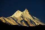
Manaslu also known as Kutang) is the eighth highest mountain
in the world, and is located in the Mansiri Himal
, part of the Nepal
ese Himalayas
, in the west-central part of Nepal. Its name, which means "Mountain of the Spirit", comes from the Sanskrit word Manasa, meaning "intellect" or "soul". Manaslu was first climbed on May 9, 1956 by Toshio Imanishi and Gyalzen Norbu, members of a Japan
ese expedition. It is said that "just as the British consider Everest their mountain, Manaslu has always been a Japanese mountain".
Manaslu at 8156 metres (26,758.5 ft) above mean sea level (m.s.l) is the highest peak in the Lamjung District
and is located about forty miles east of Annapurna
. The mountain's long ridges and valley glaciers offer feasible approaches from all directions, and culminate in a peak that towers steeply above its surrounding landscape, and is a dominant feature when viewed from afar.
The Manaslu region offers a variety of trekking options. The popular Manaslu trekking route of 177 kilometres (110 mi), skirts the Manaslu massif over the pass down to Annapurna
. The Nepalese Government only permitted trekking of this circuit in 1991. The trekking trail follows an ancient salt-trading route along the Budhi Gandaki river
. Enroute, 10 peaks over 6500 metres (21,325.5 ft) are visible, including a few over 7000 metres (22,965.9 ft). The highest point reached along the trek route is the Larkya La at an elevation of 5235 metres (17,175.2 ft). As of May 2008, the mountain has been climbed 297 times with 53 fatalities.
Manaslu Conservation Area has been established with the primary objective of achieving conservation and sustainable management of the delimited area, which includes Manaslu.
land of Nepal
, Manaslu is a serrated "wall of snow and ice hanging in the sky". The three sides of the mountain fall in steps to terraces down below, which are sparsely inhabited with agricultural operations practiced on the land. Apart from climbing Manaslu, trekking is popular in this mountain region, as part of the Manaslu Circuit, a notable path by trekkers in Nepal.
The Manaslu Conservation Area, declared as such in December 1998 under the National Parks and Wild Life Conservation Act, subsumes Manaslu within it. The area covered under the conservation zone is 1663 square kilometre and is managed by the National Trust for Nature Conservation (NTNC) of Nepal. The status of "conservation area" applied to the Manaslu area or region was with the basic objective "To conserve and sustainable management of the natural resources and rich cultural heritage and to promote ecotourism to improve livelihood of the local people in the MCA region."
Manaslu Himal, as it is popularly known among trekkers, provides views of the snow-covered mountains of the Himalayas and allows close interaction with the different ethnic groups who live in hill villages scattered along the trek route.
The trekking route is through mountains prone to the consequences of monsoon rainfall, land slides and land falls. Encounters with passing yaks, and hypothermia
and altitude sickness
, are common. Trekking to Manaslu is thus a test of endurance.
. Starting from Arughat and extending into the Larkhe La pass, the area covers six climatic zones: the tropical and sub-tropical zone, elevation varies from 1000–2000 m (3,280.8–6,561.7 ft); the temperate zone (within elevation range of 2000–3000 m (6,561.7–9,842.5 ft); the sub-alpine zone elevation range of 3000–4000 m (9,842.5–13,123.4 ft); the alpine zone, a range of 4000–5000 m (13,123.4–16,404.2 ft)) meadows; and the arctic zone (lying above 4500 metres (14,763.8 ft)). The zones coalesce with the variation of the altitude from about 600 metres (1,968.5 ft) in the tropical zone to the 8156 metres (26,758.5 ft) summit of Manaslu in the arctic zone.
Manaslu is known in the Tibetan language
as "Kutan l", in which "tang" means the Tibetan word for a flat place. It is a very large peak with an elevation of 8156 metres (26,758.5 ft) (the world’s eighth highest mountain). In view of its favourable topography of long ridges and glacial valleys, Manaslu offers several routes to mountaineers. Important peaks surrounding Manaslu include Ngadi Chuli, Himalchuli and Baudha. A glacial saddle known as Larkya La, with an elevation of 5213 metres (17,103 ft), lies across the Nepal–Tibet border. The peak is bounded on the east by the Ganesh Himal
and the Buri Gandaki River gorge, on the west by the deep fissures of the Marysyangdi Khola with its Annapurna range of hills, to the south is the Gorkha town
at the foot of the hill (from where trekking operates during the season), which is an aerial distance of 48 kilometres (29.8 mi) to the peak. There are six established trek routes to the peak, and on the mountain the south face is reportedly the most difficult for climbing.
Climate
The permanent snow line is reckoned above 5000 metres (16,404.2 ft) elevation. Precipitation in the area is both from snowfall and rainfall; the average annual rainfall is about 1900 millimetres (74.8 in) mostly during the monsoon period, which extends from June to September. The temperatures in the area also vary widely with the climatic zone: in the subtropical zone, the average summer and winter temperatures vary in the range of 31–34 °C (87.8–93.2 F) and 8–13 °C (46.4–55.4 F) respectively; in the temperate climatic zone, the summer temperatures are 22–25 °C (71.6–77 F) and winter temperatures are -2 C when snow and frost are also experienced; in the subalpine zone, during December to May snowfall generally occurs and the mean annual temperature is 6–10 °C (42.8–50 F). The arctic zone is distinct and falls within the permanent snow line; there, the temperatures lie much below freezing zone.
Fauna
Unlike many other regions, this valley is a sanctuary to many highly endangered animals, including Snow Leopard
s and Pandas. Over 110 species of birds, 33 mammals, 11 butterflies and 3 reptiles have been recorded. Conservation of wild life in the area has been achieved by monks of the monasteries in the area by putting a hunting ban in place. This action has helped the wildlife to prosper. The area is now an important habitat for the snow leopard, grey wolf, musk deer, blue sheep and the Himalayan Thar.
Vegetation
Three main categories of vegetation have been identified in the area. These are categorised on the basis of the altitude as Low hill, Middle mountain and High mountain types with its exclusive types of dominant forests and other associated species. The types of vegetation, however, tend to overlap the adjoining ones at places. Depending on the microclimate and other aspects, an overlap of vegetation is noticed in adjacent areas. However, the forest types are fairly well defined. The flora in different forest types also does not show much variation. The valley basin has a rich ecotone diversity and includes nineteen different types of forests, most prominently Rhododendron
, and also Himalayan blue pine, which is flanked by Ganesh Himal
and the Sringi ranges. Medicinal herbs and aromatic plants, have also been recorded in different forests types and adjoining vegetation. Overall, the presence of 19 types of forests and other forms of dominant vegetation have been recorded from the area.
Ethnicity
There are two ethnicities mainly inhabiting this region; Nubri and Tsum. The branching off of the river at Chhikur divides these two ethnic domains. While Nubri has been frequently visited after Nepal opened itself for the tourism in 1950, Tsum, still retains much of its traditional culture, art, and tradition. In the central hills of the region, Gurung
s are the main ethnic group who have joined the Gurkha army in large numbers. Closer to Tibet, the Bhutias (also spelt Bhotias), akin to the Sherpa group, of Tibetan ethnicity dominate the scene as can be discerned from their flat roofed houses, and they are distinctly Buddhists. The region is dotted with austere
monasteries, maniwalls, chortens and other Buddhist religious landmarks. The traditional faith of non-violence and compassion augments the wildlife diversity of the region.
with a small party of five compatriots. They walked on foot from the Kathmandu valley
(six days of trekking from the valley), and using Manang
as their base camp they started exploring the mountain ranges, peaks and valleys of the Annapurna massif. During this exploration, while making a reconnaissance of the higher reaches of the Dudh Khola, they clearly saw Manaslu from Bumtang. Three months later, after their aborted trip to Annapurna IV, Tilman, accompanied by Major J. O. M. Roberts
(who later became popular as "the father of Himalayan trekking"), trekked to Larkya La pass and from there saw Manaslu and its plateau and concluded that there was a direct route to the summit, although they did not make an attempt on it.
After the reconnaissance visit by Tilman, there were four Japan
ese expeditions between 1950 and 1955 that explored the possibility of climbing Manaslu by the north and east faces.
In 1952, a Japanese reconnaissance party visited the area after the monsoon
season. In the following year (1953), a team of 15 climbers led by Y. Mita, after setting up base camp at Samagaon, attempted to climb via the east side but failed to reach the summit. In this first attempt by a Japanese team to summit via the north-east face, three climbers reached a height of 7750 metres (25,426.5 ft), before turning back.
In 1954, a Japanese team approaching from the Buri Gandaki route to the peak faced a hostile group of villagers at Samagaon camp. The villagers thought that the previous expeditions had displeased the gods, causing the avalanches that destroyed the Pung-gyen Monastery and the death of 18 people. As a result of this hostility, the team made a hasty retreat to Ganesh Himal. To appease local sentiments, a large donation was made to rebuild the monastery. However, this philanthropic act did not ease the atmosphere of distrust and hostility towards Japanese expeditions. Even the expedition in 1956 which successfully climbed the mountain faced this situation and as a result the next Japanese expedition only took place in 1971.
T. Imanishi (Japan) and Gyalzen Norbu (Sherpa) made the first ascent
of Manaslu on May 9, 1956. The team was led by Yuko Maki.
In 1956, David Snellgrove
, a noted scholar in Tibetan culture
and religion
, undertook a seven-month sojourn of mid-west and central Nepal. The route that he followed, accompanied by three Nepalese people, was via Bumtang and Buri Gandaki river and crossing over to the Larkya La.
1970s
The next successful climb to the summit of Manslu was in 1971. On May 17, 1971, Kazuharu Kohara and Motoki, part of an 11-man Japanese team, reached the summit via the north-west spur. Also in 1971, Kim Ho-Sup led a Korea
n expedition attempt via the north-east face. Kim Ki-Sup fell to his death on May 4. In 1972, the south-west face was climbed for the first time by an Austria
n expedition led by Wolfgang Nairz. In 1972 only, the Koreans attempted the north-east face. On April 10, an avalanche
buried their camp at 6500 metres (21,325.5 ft), killing 15 climbers including 10 Sherpas
and the Korean expedition leader Kim Ho-sup, and Kazunari Yasuhisa from Japan. In 1972, an Austria
n expedition led by Wolfgang Nairz made the first ascent via the SW face. On April 22, 1973, Gerhard Schmatz, Gerhard, Sigi Hupfauer and a Sherpa climber reached the summit via the north-east face. In the same year, a Spanish expedition led by Jaume Garcia Orts could reach only to 6100 metres (20,013.1 ft). The first Japanese women expedition led by Kyoko Sato was successful on May 4, 1974, when all members reached the summit after a failed attempt from the East ridge. They were thus the first women team (Naoko Nakaseko, Masako Uchida Mieko Mori) with Jambu Sherpa to climb an 8000 metres (26,246.7 ft) peak. However, one climber died on May 5 when she fell between camps 4 and 5. On April 26, 1975, Gerald Garcia led a 12 member Spanish team for a second time. Two members of the team Jeronimo Lopez and Sonam Sherpa of a Spanish
reached the summit via the north-east face. On April 26, 1975, Gerald Garcia, Jeronimo Lopez and Sonam Sherpa of a Spanish
expedition reached the summit via the north-east face.
1980s
In the pre-monsoon period of 1980, a South Korean team led by Li In Jung reached the summit via the normal route, which was the eighth ascent to the peak. The year 1981 marked several expeditions: the largest contingent of 13 climbers of a team organized by the Sport-Eiselin of Zurich led by H. V. Kaenel, made it to the summit along the normal route; in autumn, French mountaineers opened a new route, a variation of the west face route; and a Japanese team, led by Y. Kato, made an ascent via the normal route. In 1983, two climbers from Yugoslavia
, trying to climb the peak from the south face, were buried under an avalanche
. A Korean team reached the summit in the autumn of the same year. A German team led by G. Harter was successful in climbing the peak via the south face, which followed the "1972 Tyrolean Route".
During the winter of 1983-84, a Polish
team led by L. Korniszewski successfully followed the Tyrolean Route. In the spring season of 1984, a Yugoslav team led by A. Kunaver climbed the peak via the south face. During the same year, in autumn, Polish teams climbed the south ridge and south-east face. On January 14, 1984, Maciej Berbeka
and Ryszard Gajewski
of a Polish
expedition made the first winter ascent via the normal route. On November 10, 1986, Jerzy Kukuczka
and Artur Hajzer reached the summit via a new route, in Alpine style
, with no supplementary oxygen. Carlos Carsolio climbed the east summit of Manaslu, and then Kukuczka and Hajzer climbed the main summit.
In 1986, a joint team from Poland
and Mexico
led by Kukuczka opened a new route along the east ridge, descending via the north-east face.
1990s
On May 2, 1993, Sepp Brunner, Gerhard Floßmann, Sepp Hinding and Dr. Michael Leuprecht reached the summit via the normal route and descended on skis from 7000 metres (22,965.9 ft) to the basecamp. The Austria
n expedition was led by Arthur Haid. On December 8, 1995, Anatoli Boukreev summited Manaslu with the Second Kazakhstan
Himalaya Expedition. On May 12, 1996, Carlos Carsolio
and his younger brother Alfredo, reached the summit of Manaslu. For Carsolio it was his fourteenth and final eight-thousander
, becoming the fourth person in history and the youngest to achieve the feat. In 1997, Charlie Mace made the first American
ascent, and on May 13, 2002, five Americans and two Sherpas reached the summit.
2000s
During the spring of 2000, there were four expeditions to Manaslu. One climb was on the east face by the 'Japan 2000 Expedition' led by Yoshio Maruyama. The other three were on the north-east ridge: the ETB 2000 Expedition of Spain led by Felix Maria I. Iriate; the 2000 Korean Manaslu Expedition of Korea led by Han Wang Yong; and the Manaslu 2000 Expedition from Italy led by Franco Brunello. On May 22, 2001, a three-member team of Ukraine
Himalaya 2001 Expedition comprising Serguiy Kovalov, Vadim Leontiev and Vladislav Terzyul successfully summited Manaslu via the challenging south-east face; all climbed without oxygen support. During the autumn of 2001, three members and a sherpa of the Japan Workers Alpine Federation climbed the peak via the north-east face on October 9, 2001.
Piotr Pustelnik and Krzysztof Tarasewicz climbed Manaslu on May 17, 2003. However, Dariusz Zaluski, Anna Czerwinska and Barbara Drousek, who started the climb after Piotr and Krzysztof, had to turn back due to strong winds and bad weather. With this ascent Pustelnik has summited 12 of the world's 14 highest peaks (Broad Peak and Annapurna are left).
On May 29, 2006, Australia
n mountaineer Sue Fear
died after falling into a crevasse on her descent after summiting. In 2008, Valerie Parkinson was the first British woman to climb Manaslu.
Risk
Traditionally, the "spring" or " pre-monsoon" season, is the least hazardous for bad weather, snowfall and avalanches. Manaslu is one of the more risky 8000ers to climb: as of May 2008, there have been 297 ascents of Manaslu and 53 deaths on the mountain, making it "the 4th most dangerous 8000m peak, behind Annapurna
, Nanga Parbat
, and K2
."
.
The trek follows an ancient salt–trading route along the steep sided Budhi Gandaki river. From Deng, the slopes of ravines ease and views of snow peaks start appearing from Ligaon. Further from Lhogaon, an impressive view of Manaslu, with its double peak, appears described as "a soaring monarch with a double-edged summit towering above fields of barley".
The route follows the pine-forested Syala village, which has the backdrop of many horseshoe-shaped peaks, and reaches the village of Samagaon (Sama) at the foot of Manaslu. There is a Buddhist monastery at Samagaon, where monks and nuns reside. After half a day’s trek from Samagaon, the village of Samdo is reached. Samdo is the highest village in the Budhi Gandaki valley and is inhabited by Bhotias. This village commands a view of the valley and Pang Phuchi village with a backdrop of the Tibetan border. Further trekking leads along a major secondary valley to the Larkha La. Along this route, Cheo Himal, Himlung Himal and Kang Guru are seen, along with occasional views of the Annapurna massif. From here, the meadowland of Bimtang (Bimdakhoti) at elevation 1500 metres (4,921.3 ft) is reached, from where Manaslu is clearly visible. From Manaslu, the circuit passes through Dudh Khola (a tributary of Marsyangdi river), criss-crosses Marsyangdi River before reaching Bhulbule, Tarukha Ghat, crosses the Chepe Khola and Dorandi Khola before returning to Gorkha.
Two alternative routes are also popular. One is on the Annapurna trail but leaves it at Dharapani to reach Manang
, crossing Thorong La and Jomsom
(Kali Gandaki valley). From Jomsom
flights depart to Pokhara
. The other alternative route is from Bhulbule, crossing Marsyangdi to Khudi, divert from Annapurna trail and trek cross country through valleys and ridges to Sisuwa town on the bank of Begnas Tal. From here a road approach is available to Pokhara.
When trekking through the Manaslu region, ten peaks of over 6500 metres (21,325.5 ft) in height are visible, including peaks of over7000 metres (22,965.9 ft) elevation. People add Tsum Valley and the Ganesh Himal Base Camp as acclimatization trips before going on expeditions through the high passes. The Tsum region, which was restricted for tourists for a long time, is now the centre of attraction for intrepid trekkers, with the government of Nepal recently opening it for group tourists. In order to retain its pristine culture and sustain its fragile ecosystem, the Tsum Welfare Committee is involved in the promotion of responsible tourism in Tsum. However, local participation for sustainable tourism
is still a challenging task with a long road ahead.
, the government of Nepal has an infrastructure project titled "Manaslu Eco-tourism Development Project" under implementation. The objective is to improve the capacity of the Manaslu area to support tourism in an environmentally benign manner.
Mountain
Image:Himalaya_annotated.jpg|thumb|right|The Himalayan mountain range with Mount Everestrect 58 14 160 49 Chomo Lonzorect 200 28 335 52 Makalurect 378 24 566 45 Mount Everestrect 188 581 920 656 Tibetan Plateaurect 250 406 340 427 Rong River...
in the world, and is located in the Mansiri Himal
Mansiri Himal
Mansiri Himal is a small, high subrange. of the Himalaya in north-central Nepal, about 100km northwest of Kathmandu. The Marsyangdi River separates the Mansiri from the Annapurnas to the southwest, then an upper tributary Dudh Khola separates Peri Himal to the northwest...
, part of the Nepal
Nepal
Nepal , officially the Federal Democratic Republic of Nepal, is a landlocked sovereign state located in South Asia. It is located in the Himalayas and bordered to the north by the People's Republic of China, and to the south, east, and west by the Republic of India...
ese Himalayas
Himalayas
The Himalaya Range or Himalaya Mountains Sanskrit: Devanagari: हिमालय, literally "abode of snow"), usually called the Himalayas or Himalaya for short, is a mountain range in Asia, separating the Indian subcontinent from the Tibetan Plateau...
, in the west-central part of Nepal. Its name, which means "Mountain of the Spirit", comes from the Sanskrit word Manasa, meaning "intellect" or "soul". Manaslu was first climbed on May 9, 1956 by Toshio Imanishi and Gyalzen Norbu, members of a Japan
Japan
Japan is an island nation in East Asia. Located in the Pacific Ocean, it lies to the east of the Sea of Japan, China, North Korea, South Korea and Russia, stretching from the Sea of Okhotsk in the north to the East China Sea and Taiwan in the south...
ese expedition. It is said that "just as the British consider Everest their mountain, Manaslu has always been a Japanese mountain".
Manaslu at 8156 metres (26,758.5 ft) above mean sea level (m.s.l) is the highest peak in the Lamjung District
Lamjung District
Lamjung District of 177,149. Lamjung mainly consists of agricultural villages. The picture on the right is a scene taken in a village called "Kapur Gaun". CHESS Nepal is based in Lamjung District.-Village Development Committees :*Archalebot...
and is located about forty miles east of Annapurna
Annapurna
Annapurna is a section of the Himalayas in north-central Nepal that includes Annapurna I, thirteen additional peaks over and 16 more over ....
. The mountain's long ridges and valley glaciers offer feasible approaches from all directions, and culminate in a peak that towers steeply above its surrounding landscape, and is a dominant feature when viewed from afar.
The Manaslu region offers a variety of trekking options. The popular Manaslu trekking route of 177 kilometres (110 mi), skirts the Manaslu massif over the pass down to Annapurna
Annapurna
Annapurna is a section of the Himalayas in north-central Nepal that includes Annapurna I, thirteen additional peaks over and 16 more over ....
. The Nepalese Government only permitted trekking of this circuit in 1991. The trekking trail follows an ancient salt-trading route along the Budhi Gandaki river
Budhi Gandak
The Burhi Gandak River is a tributary of the Ganges. It is known as Sikrahana in its upper reaches. The Burhi Gandak flows parallel to and east of the Gandak River in an old channel.-Course:...
. Enroute, 10 peaks over 6500 metres (21,325.5 ft) are visible, including a few over 7000 metres (22,965.9 ft). The highest point reached along the trek route is the Larkya La at an elevation of 5235 metres (17,175.2 ft). As of May 2008, the mountain has been climbed 297 times with 53 fatalities.
Manaslu Conservation Area has been established with the primary objective of achieving conservation and sustainable management of the delimited area, which includes Manaslu.
General
Set in the northern Himalayan range in the GorkhaGorkha District
Gorkha District of 288,134. It is the location of the Manakamana Temple. Also, the temples of great sage Gorakh Nath and goddess Gorakh Kali temple is located in district, after which the district got its name. Four major rivers run within and along it, they are Chepe, Daraudi, Marsyangdi and...
land of Nepal
Nepal
Nepal , officially the Federal Democratic Republic of Nepal, is a landlocked sovereign state located in South Asia. It is located in the Himalayas and bordered to the north by the People's Republic of China, and to the south, east, and west by the Republic of India...
, Manaslu is a serrated "wall of snow and ice hanging in the sky". The three sides of the mountain fall in steps to terraces down below, which are sparsely inhabited with agricultural operations practiced on the land. Apart from climbing Manaslu, trekking is popular in this mountain region, as part of the Manaslu Circuit, a notable path by trekkers in Nepal.
The Manaslu Conservation Area, declared as such in December 1998 under the National Parks and Wild Life Conservation Act, subsumes Manaslu within it. The area covered under the conservation zone is 1663 square kilometre and is managed by the National Trust for Nature Conservation (NTNC) of Nepal. The status of "conservation area" applied to the Manaslu area or region was with the basic objective "To conserve and sustainable management of the natural resources and rich cultural heritage and to promote ecotourism to improve livelihood of the local people in the MCA region."
Manaslu Himal, as it is popularly known among trekkers, provides views of the snow-covered mountains of the Himalayas and allows close interaction with the different ethnic groups who live in hill villages scattered along the trek route.
The trekking route is through mountains prone to the consequences of monsoon rainfall, land slides and land falls. Encounters with passing yaks, and hypothermia
Hypothermia
Hypothermia is a condition in which core temperature drops below the required temperature for normal metabolism and body functions which is defined as . Body temperature is usually maintained near a constant level of through biologic homeostasis or thermoregulation...
and altitude sickness
Altitude sickness
Altitude sickness—also known as acute mountain sickness , altitude illness, hypobaropathy, or soroche—is a pathological effect of high altitude on humans, caused by acute exposure to low partial pressure of oxygen at high altitude...
, are common. Trekking to Manaslu is thus a test of endurance.
Geography
The region, which is also termed the Manaslu Conservation Area, comprises sub-tropical Himalayan foothills to arid Trans-Himalayan high pastures bordering TibetTibet
Tibet is a plateau region in Asia, north-east of the Himalayas. It is the traditional homeland of the Tibetan people as well as some other ethnic groups such as Monpas, Qiang, and Lhobas, and is now also inhabited by considerable numbers of Han and Hui people...
. Starting from Arughat and extending into the Larkhe La pass, the area covers six climatic zones: the tropical and sub-tropical zone, elevation varies from 1000–2000 m (3,280.8–6,561.7 ft); the temperate zone (within elevation range of 2000–3000 m (6,561.7–9,842.5 ft); the sub-alpine zone elevation range of 3000–4000 m (9,842.5–13,123.4 ft); the alpine zone, a range of 4000–5000 m (13,123.4–16,404.2 ft)) meadows; and the arctic zone (lying above 4500 metres (14,763.8 ft)). The zones coalesce with the variation of the altitude from about 600 metres (1,968.5 ft) in the tropical zone to the 8156 metres (26,758.5 ft) summit of Manaslu in the arctic zone.
Manaslu is known in the Tibetan language
Tibetan language
The Tibetan languages are a cluster of mutually-unintelligible Tibeto-Burman languages spoken primarily by Tibetan peoples who live across a wide area of eastern Central Asia bordering the Indian subcontinent, including the Tibetan Plateau and the northern Indian subcontinent in Baltistan, Ladakh,...
as "Kutan l", in which "tang" means the Tibetan word for a flat place. It is a very large peak with an elevation of 8156 metres (26,758.5 ft) (the world’s eighth highest mountain). In view of its favourable topography of long ridges and glacial valleys, Manaslu offers several routes to mountaineers. Important peaks surrounding Manaslu include Ngadi Chuli, Himalchuli and Baudha. A glacial saddle known as Larkya La, with an elevation of 5213 metres (17,103 ft), lies across the Nepal–Tibet border. The peak is bounded on the east by the Ganesh Himal
Ganesh Himal
Ganesh Himāl is a sub-range of the Himalaya located mostly in north-central Nepal, but some peaks lie on the border with Tibet. TheTrisuli Gandaki valley on the east separates it from the Langtang Himal; the...
and the Buri Gandaki River gorge, on the west by the deep fissures of the Marysyangdi Khola with its Annapurna range of hills, to the south is the Gorkha town
Gurkha
Gurkha are people from Nepal who take their name from the Gorkha District. Gurkhas are best known for their history in the Indian Army's Gorkha regiments, the British Army's Brigade of Gurkhas and the Nepalese Army. Gurkha units are closely associated with the kukri, a forward-curving Nepalese knife...
at the foot of the hill (from where trekking operates during the season), which is an aerial distance of 48 kilometres (29.8 mi) to the peak. There are six established trek routes to the peak, and on the mountain the south face is reportedly the most difficult for climbing.
Climate
The permanent snow line is reckoned above 5000 metres (16,404.2 ft) elevation. Precipitation in the area is both from snowfall and rainfall; the average annual rainfall is about 1900 millimetres (74.8 in) mostly during the monsoon period, which extends from June to September. The temperatures in the area also vary widely with the climatic zone: in the subtropical zone, the average summer and winter temperatures vary in the range of 31–34 °C (87.8–93.2 F) and 8–13 °C (46.4–55.4 F) respectively; in the temperate climatic zone, the summer temperatures are 22–25 °C (71.6–77 F) and winter temperatures are -2 C when snow and frost are also experienced; in the subalpine zone, during December to May snowfall generally occurs and the mean annual temperature is 6–10 °C (42.8–50 F). The arctic zone is distinct and falls within the permanent snow line; there, the temperatures lie much below freezing zone.
Fauna
Unlike many other regions, this valley is a sanctuary to many highly endangered animals, including Snow Leopard
Snow Leopard
The snow leopard is a moderately large cat native to the mountain ranges of South Asia and Central Asia...
s and Pandas. Over 110 species of birds, 33 mammals, 11 butterflies and 3 reptiles have been recorded. Conservation of wild life in the area has been achieved by monks of the monasteries in the area by putting a hunting ban in place. This action has helped the wildlife to prosper. The area is now an important habitat for the snow leopard, grey wolf, musk deer, blue sheep and the Himalayan Thar.
Vegetation
Three main categories of vegetation have been identified in the area. These are categorised on the basis of the altitude as Low hill, Middle mountain and High mountain types with its exclusive types of dominant forests and other associated species. The types of vegetation, however, tend to overlap the adjoining ones at places. Depending on the microclimate and other aspects, an overlap of vegetation is noticed in adjacent areas. However, the forest types are fairly well defined. The flora in different forest types also does not show much variation. The valley basin has a rich ecotone diversity and includes nineteen different types of forests, most prominently Rhododendron
Rhododendron
Rhododendron is a genus of over 1 000 species of woody plants in the heath family, most with showy flowers...
, and also Himalayan blue pine, which is flanked by Ganesh Himal
Ganesh Himal
Ganesh Himāl is a sub-range of the Himalaya located mostly in north-central Nepal, but some peaks lie on the border with Tibet. TheTrisuli Gandaki valley on the east separates it from the Langtang Himal; the...
and the Sringi ranges. Medicinal herbs and aromatic plants, have also been recorded in different forests types and adjoining vegetation. Overall, the presence of 19 types of forests and other forms of dominant vegetation have been recorded from the area.
Ethnicity
There are two ethnicities mainly inhabiting this region; Nubri and Tsum. The branching off of the river at Chhikur divides these two ethnic domains. While Nubri has been frequently visited after Nepal opened itself for the tourism in 1950, Tsum, still retains much of its traditional culture, art, and tradition. In the central hills of the region, Gurung
Gurung
The Gurung people, also called Tamu, are an ethnic group that migrated from Mongolia in the 6th century to the central region of Nepal. Gurungs, like other east Asian featured peoples of Nepal such as Sherpa, Tamang, Thakali, Magar, Manaaggi, Mustaaggi, and Walunggi, are the indigenous people of...
s are the main ethnic group who have joined the Gurkha army in large numbers. Closer to Tibet, the Bhutias (also spelt Bhotias), akin to the Sherpa group, of Tibetan ethnicity dominate the scene as can be discerned from their flat roofed houses, and they are distinctly Buddhists. The region is dotted with austere
Austere
Austere is the first release by the band Sparta, just one year after break-up of their former band At the Drive-In.-Track listing:#"Mye" – 3:33#"Cataract" – 5:09#"Vacant Skies" – 3:32#"Echodyne Harmonic " – 3:50-Personnel:...
monasteries, maniwalls, chortens and other Buddhist religious landmarks. The traditional faith of non-violence and compassion augments the wildlife diversity of the region.
History
In 1950, H. W. Tilman was the first European to lead an expedition to the Annapurna RangeAnnapurna
Annapurna is a section of the Himalayas in north-central Nepal that includes Annapurna I, thirteen additional peaks over and 16 more over ....
with a small party of five compatriots. They walked on foot from the Kathmandu valley
Kathmandu Valley
The Kathmandu Valley , located in Nepal, lies at the crossroads of ancient civilizations of Asia, and has at least 130 important monuments, including several places of pilgrimage for the Hindus and the Buddhists. There are seven UNESCO World Heritage Sites within this valley.-Etymology:The city of...
(six days of trekking from the valley), and using Manang
Manang
Manang is a town in the Manang District of Nepal. It is located at 28°40'0N 84°1'0E with an altitude of . At the time of the 1991 Nepal census it had a population of 391 people living in 120 individual households....
as their base camp they started exploring the mountain ranges, peaks and valleys of the Annapurna massif. During this exploration, while making a reconnaissance of the higher reaches of the Dudh Khola, they clearly saw Manaslu from Bumtang. Three months later, after their aborted trip to Annapurna IV, Tilman, accompanied by Major J. O. M. Roberts
J. O. M. Roberts
James Owen Merion Roberts was one of the greatest Himalayan mountaineer-explorers of the twentieth century, a highly decorated Army officer who achieved his greatest renown as "the father of trekking" in Nepal...
(who later became popular as "the father of Himalayan trekking"), trekked to Larkya La pass and from there saw Manaslu and its plateau and concluded that there was a direct route to the summit, although they did not make an attempt on it.
After the reconnaissance visit by Tilman, there were four Japan
Japan
Japan is an island nation in East Asia. Located in the Pacific Ocean, it lies to the east of the Sea of Japan, China, North Korea, South Korea and Russia, stretching from the Sea of Okhotsk in the north to the East China Sea and Taiwan in the south...
ese expeditions between 1950 and 1955 that explored the possibility of climbing Manaslu by the north and east faces.
In 1952, a Japanese reconnaissance party visited the area after the monsoon
Monsoon
Monsoon is traditionally defined as a seasonal reversing wind accompanied by corresponding changes in precipitation, but is now used to describe seasonal changes in atmospheric circulation and precipitation associated with the asymmetric heating of land and sea...
season. In the following year (1953), a team of 15 climbers led by Y. Mita, after setting up base camp at Samagaon, attempted to climb via the east side but failed to reach the summit. In this first attempt by a Japanese team to summit via the north-east face, three climbers reached a height of 7750 metres (25,426.5 ft), before turning back.
In 1954, a Japanese team approaching from the Buri Gandaki route to the peak faced a hostile group of villagers at Samagaon camp. The villagers thought that the previous expeditions had displeased the gods, causing the avalanches that destroyed the Pung-gyen Monastery and the death of 18 people. As a result of this hostility, the team made a hasty retreat to Ganesh Himal. To appease local sentiments, a large donation was made to rebuild the monastery. However, this philanthropic act did not ease the atmosphere of distrust and hostility towards Japanese expeditions. Even the expedition in 1956 which successfully climbed the mountain faced this situation and as a result the next Japanese expedition only took place in 1971.
T. Imanishi (Japan) and Gyalzen Norbu (Sherpa) made the first ascent
First ascent
In climbing, a first ascent is the first successful, documented attainment of the top of a mountain, or the first to follow a particular climbing route...
of Manaslu on May 9, 1956. The team was led by Yuko Maki.
In 1956, David Snellgrove
David Snellgrove
David Llewellyn Snellgrove is a British Tibetologist noted for his pioneering work on Buddhism in Tibet as well as his many travelogues.-Biography:...
, a noted scholar in Tibetan culture
Tibetan culture
Tibetan culture developed under the influence of a number of factors. Contact with neighboring countries and cultures- including Nepal, India and China - have influenced the development of Tibetan culture, but the Himalayan region's remoteness and inaccessibility have preserved distinctive local...
and religion
Tibetan Buddhism
Tibetan Buddhism is the body of Buddhist religious doctrine and institutions characteristic of Tibet and certain regions of the Himalayas, including northern Nepal, Bhutan, and India . It is the state religion of Bhutan...
, undertook a seven-month sojourn of mid-west and central Nepal. The route that he followed, accompanied by three Nepalese people, was via Bumtang and Buri Gandaki river and crossing over to the Larkya La.
1970s
The next successful climb to the summit of Manslu was in 1971. On May 17, 1971, Kazuharu Kohara and Motoki, part of an 11-man Japanese team, reached the summit via the north-west spur. Also in 1971, Kim Ho-Sup led a Korea
Korea
Korea ) is an East Asian geographic region that is currently divided into two separate sovereign states — North Korea and South Korea. Located on the Korean Peninsula, Korea is bordered by the People's Republic of China to the northwest, Russia to the northeast, and is separated from Japan to the...
n expedition attempt via the north-east face. Kim Ki-Sup fell to his death on May 4. In 1972, the south-west face was climbed for the first time by an Austria
Austria
Austria , officially the Republic of Austria , is a landlocked country of roughly 8.4 million people in Central Europe. It is bordered by the Czech Republic and Germany to the north, Slovakia and Hungary to the east, Slovenia and Italy to the south, and Switzerland and Liechtenstein to the...
n expedition led by Wolfgang Nairz. In 1972 only, the Koreans attempted the north-east face. On April 10, an avalanche
Avalanche
An avalanche is a sudden rapid flow of snow down a slope, occurring when either natural triggers or human activity causes a critical escalating transition from the slow equilibrium evolution of the snow pack. Typically occurring in mountainous terrain, an avalanche can mix air and water with the...
buried their camp at 6500 metres (21,325.5 ft), killing 15 climbers including 10 Sherpas
Sherpa people
The Sherpa are an ethnic group from the most mountainous region of Nepal, high in the Himalayas. Sherpas migrated from the Kham region in eastern Tibet to Nepal within the last 300–400 years.The initial mountainous migration from Tibet was a search for beyul...
and the Korean expedition leader Kim Ho-sup, and Kazunari Yasuhisa from Japan. In 1972, an Austria
Austria
Austria , officially the Republic of Austria , is a landlocked country of roughly 8.4 million people in Central Europe. It is bordered by the Czech Republic and Germany to the north, Slovakia and Hungary to the east, Slovenia and Italy to the south, and Switzerland and Liechtenstein to the...
n expedition led by Wolfgang Nairz made the first ascent via the SW face. On April 22, 1973, Gerhard Schmatz, Gerhard, Sigi Hupfauer and a Sherpa climber reached the summit via the north-east face. In the same year, a Spanish expedition led by Jaume Garcia Orts could reach only to 6100 metres (20,013.1 ft). The first Japanese women expedition led by Kyoko Sato was successful on May 4, 1974, when all members reached the summit after a failed attempt from the East ridge. They were thus the first women team (Naoko Nakaseko, Masako Uchida Mieko Mori) with Jambu Sherpa to climb an 8000 metres (26,246.7 ft) peak. However, one climber died on May 5 when she fell between camps 4 and 5. On April 26, 1975, Gerald Garcia led a 12 member Spanish team for a second time. Two members of the team Jeronimo Lopez and Sonam Sherpa of a Spanish
Spain
Spain , officially the Kingdom of Spain languages]] under the European Charter for Regional or Minority Languages. In each of these, Spain's official name is as follows:;;;;;;), is a country and member state of the European Union located in southwestern Europe on the Iberian Peninsula...
reached the summit via the north-east face. On April 26, 1975, Gerald Garcia, Jeronimo Lopez and Sonam Sherpa of a Spanish
Spain
Spain , officially the Kingdom of Spain languages]] under the European Charter for Regional or Minority Languages. In each of these, Spain's official name is as follows:;;;;;;), is a country and member state of the European Union located in southwestern Europe on the Iberian Peninsula...
expedition reached the summit via the north-east face.
1980s
In the pre-monsoon period of 1980, a South Korean team led by Li In Jung reached the summit via the normal route, which was the eighth ascent to the peak. The year 1981 marked several expeditions: the largest contingent of 13 climbers of a team organized by the Sport-Eiselin of Zurich led by H. V. Kaenel, made it to the summit along the normal route; in autumn, French mountaineers opened a new route, a variation of the west face route; and a Japanese team, led by Y. Kato, made an ascent via the normal route. In 1983, two climbers from Yugoslavia
Yugoslavia
Yugoslavia refers to three political entities that existed successively on the western part of the Balkans during most of the 20th century....
, trying to climb the peak from the south face, were buried under an avalanche
Avalanche
An avalanche is a sudden rapid flow of snow down a slope, occurring when either natural triggers or human activity causes a critical escalating transition from the slow equilibrium evolution of the snow pack. Typically occurring in mountainous terrain, an avalanche can mix air and water with the...
. A Korean team reached the summit in the autumn of the same year. A German team led by G. Harter was successful in climbing the peak via the south face, which followed the "1972 Tyrolean Route".
During the winter of 1983-84, a Polish
Poland
Poland , officially the Republic of Poland , is a country in Central Europe bordered by Germany to the west; the Czech Republic and Slovakia to the south; Ukraine, Belarus and Lithuania to the east; and the Baltic Sea and Kaliningrad Oblast, a Russian exclave, to the north...
team led by L. Korniszewski successfully followed the Tyrolean Route. In the spring season of 1984, a Yugoslav team led by A. Kunaver climbed the peak via the south face. During the same year, in autumn, Polish teams climbed the south ridge and south-east face. On January 14, 1984, Maciej Berbeka
Maciej Berbeka
Maciej Berbeka is a Polish mountaineer.On January 14, 1984, together with Ryszard Gajewski he made the first winter ascent of Manaslu.On February 12, 1985, together with Maciej Pawlikowski he made the first winter ascent of Cho Oyu....
and Ryszard Gajewski
Ryszard Gajewski
Ryszard Gajewski is a Polish mountaineer best known for the first winter ascent of Manaslu on January 12, 1984 together with Maciej Berbeka.- Eight-thousanders :* Manaslu with Maciej Berbeka...
of a Polish
Poland
Poland , officially the Republic of Poland , is a country in Central Europe bordered by Germany to the west; the Czech Republic and Slovakia to the south; Ukraine, Belarus and Lithuania to the east; and the Baltic Sea and Kaliningrad Oblast, a Russian exclave, to the north...
expedition made the first winter ascent via the normal route. On November 10, 1986, Jerzy Kukuczka
Jerzy Kukuczka
Jerzy Kukuczka , born in Katowice, Poland, was a Polish alpine and high-altitude climber. On 18 September 1987, he became the second man, after Reinhold Messner, to climb all fourteen eight-thousanders in the world....
and Artur Hajzer reached the summit via a new route, in Alpine style
Alpine style
Alpine style refers to mountaineering in a self-sufficient manner, thereby carrying all of one's food, shelter, equipment etc. as one climbs, as opposed to expedition style mountaineering which involves setting up a fixed line of stocked camps on the mountain which can be accessed at one's leisure...
, with no supplementary oxygen. Carlos Carsolio climbed the east summit of Manaslu, and then Kukuczka and Hajzer climbed the main summit.
In 1986, a joint team from Poland
Poland
Poland , officially the Republic of Poland , is a country in Central Europe bordered by Germany to the west; the Czech Republic and Slovakia to the south; Ukraine, Belarus and Lithuania to the east; and the Baltic Sea and Kaliningrad Oblast, a Russian exclave, to the north...
and Mexico
Mexico
The United Mexican States , commonly known as Mexico , is a federal constitutional republic in North America. It is bordered on the north by the United States; on the south and west by the Pacific Ocean; on the southeast by Guatemala, Belize, and the Caribbean Sea; and on the east by the Gulf of...
led by Kukuczka opened a new route along the east ridge, descending via the north-east face.
1990s
On May 2, 1993, Sepp Brunner, Gerhard Floßmann, Sepp Hinding and Dr. Michael Leuprecht reached the summit via the normal route and descended on skis from 7000 metres (22,965.9 ft) to the basecamp. The Austria
Austria
Austria , officially the Republic of Austria , is a landlocked country of roughly 8.4 million people in Central Europe. It is bordered by the Czech Republic and Germany to the north, Slovakia and Hungary to the east, Slovenia and Italy to the south, and Switzerland and Liechtenstein to the...
n expedition was led by Arthur Haid. On December 8, 1995, Anatoli Boukreev summited Manaslu with the Second Kazakhstan
Kazakhstan
Kazakhstan , officially the Republic of Kazakhstan, is a transcontinental country in Central Asia and Eastern Europe. Ranked as the ninth largest country in the world, it is also the world's largest landlocked country; its territory of is greater than Western Europe...
Himalaya Expedition. On May 12, 1996, Carlos Carsolio
Carlos Carsolio
Carlos Carsolio Larrea is a Mexican mountain climber. Carsolio is known for being the fourth man and the second youngest to climb the world's 14 eight-thousander mountain peaks, all of them without supplementary oxygen .- Early years :Carsolio, the eldest of...
and his younger brother Alfredo, reached the summit of Manaslu. For Carsolio it was his fourteenth and final eight-thousander
Eight-thousander
The eight-thousanders are the fourteen independent mountains on Earth that are more than high above sea level. They are all located in the Himalayan and Karakoram mountain ranges in Asia....
, becoming the fourth person in history and the youngest to achieve the feat. In 1997, Charlie Mace made the first American
United States
The United States of America is a federal constitutional republic comprising fifty states and a federal district...
ascent, and on May 13, 2002, five Americans and two Sherpas reached the summit.
2000s
During the spring of 2000, there were four expeditions to Manaslu. One climb was on the east face by the 'Japan 2000 Expedition' led by Yoshio Maruyama. The other three were on the north-east ridge: the ETB 2000 Expedition of Spain led by Felix Maria I. Iriate; the 2000 Korean Manaslu Expedition of Korea led by Han Wang Yong; and the Manaslu 2000 Expedition from Italy led by Franco Brunello. On May 22, 2001, a three-member team of Ukraine
Ukraine
Ukraine is a country in Eastern Europe. It has an area of 603,628 km², making it the second largest contiguous country on the European continent, after Russia...
Himalaya 2001 Expedition comprising Serguiy Kovalov, Vadim Leontiev and Vladislav Terzyul successfully summited Manaslu via the challenging south-east face; all climbed without oxygen support. During the autumn of 2001, three members and a sherpa of the Japan Workers Alpine Federation climbed the peak via the north-east face on October 9, 2001.
Piotr Pustelnik and Krzysztof Tarasewicz climbed Manaslu on May 17, 2003. However, Dariusz Zaluski, Anna Czerwinska and Barbara Drousek, who started the climb after Piotr and Krzysztof, had to turn back due to strong winds and bad weather. With this ascent Pustelnik has summited 12 of the world's 14 highest peaks (Broad Peak and Annapurna are left).
On May 29, 2006, Australia
Australia
Australia , officially the Commonwealth of Australia, is a country in the Southern Hemisphere comprising the mainland of the Australian continent, the island of Tasmania, and numerous smaller islands in the Indian and Pacific Oceans. It is the world's sixth-largest country by total area...
n mountaineer Sue Fear
Sue Fear
Susan Erica Fear was an Australian mountain climber, passionate supporter of the Fred Hollows Foundation and a 2005 recipient of the Order of Australia medal in the Queen's birthday honours...
died after falling into a crevasse on her descent after summiting. In 2008, Valerie Parkinson was the first British woman to climb Manaslu.
Risk
Traditionally, the "spring" or " pre-monsoon" season, is the least hazardous for bad weather, snowfall and avalanches. Manaslu is one of the more risky 8000ers to climb: as of May 2008, there have been 297 ascents of Manaslu and 53 deaths on the mountain, making it "the 4th most dangerous 8000m peak, behind Annapurna
Annapurna
Annapurna is a section of the Himalayas in north-central Nepal that includes Annapurna I, thirteen additional peaks over and 16 more over ....
, Nanga Parbat
Nanga Parbat
Nanga Parbat is the ninth highest mountain on Earth, the second highest mountain in Pakistan and among the eight-thousanders with a summit elevation of 8,126 meters...
, and K2
K2
K2 is the second-highest mountain on Earth, after Mount Everest...
."
Trekking in the Manaslu region
The Manaslu region offers a variety of trekking options. The Manaslu Circuit Trek now usually starts in Arughat Bazaar and ends two to three weekshttp://wikitravel.org/en/Manaslu_Trek later in Besisahar, the starting point of the Annapurna Circuit Trek. Until recently the trek used require camping, but building of tea-houses means the trek can be completed using local accommodation. The trek requires a Restricted Area Permit of $50 per week and that trekkers travel in a group of two with a registered guide. The trek lies on the newly developed Great Himalaya TrailGreat Himalaya Trail
The Great Himalaya Trail is a proposed trail of more than 4500 km stretching the length of the Greater Himalaya range from Nanga Parbat in Pakistan to Namche Barwa in Tibet thus passing through Pakistan, India, Nepal, Bhutan and Tibet in China...
.
The trek follows an ancient salt–trading route along the steep sided Budhi Gandaki river. From Deng, the slopes of ravines ease and views of snow peaks start appearing from Ligaon. Further from Lhogaon, an impressive view of Manaslu, with its double peak, appears described as "a soaring monarch with a double-edged summit towering above fields of barley".
The route follows the pine-forested Syala village, which has the backdrop of many horseshoe-shaped peaks, and reaches the village of Samagaon (Sama) at the foot of Manaslu. There is a Buddhist monastery at Samagaon, where monks and nuns reside. After half a day’s trek from Samagaon, the village of Samdo is reached. Samdo is the highest village in the Budhi Gandaki valley and is inhabited by Bhotias. This village commands a view of the valley and Pang Phuchi village with a backdrop of the Tibetan border. Further trekking leads along a major secondary valley to the Larkha La. Along this route, Cheo Himal, Himlung Himal and Kang Guru are seen, along with occasional views of the Annapurna massif. From here, the meadowland of Bimtang (Bimdakhoti) at elevation 1500 metres (4,921.3 ft) is reached, from where Manaslu is clearly visible. From Manaslu, the circuit passes through Dudh Khola (a tributary of Marsyangdi river), criss-crosses Marsyangdi River before reaching Bhulbule, Tarukha Ghat, crosses the Chepe Khola and Dorandi Khola before returning to Gorkha.
Two alternative routes are also popular. One is on the Annapurna trail but leaves it at Dharapani to reach Manang
Manang
Manang is a town in the Manang District of Nepal. It is located at 28°40'0N 84°1'0E with an altitude of . At the time of the 1991 Nepal census it had a population of 391 people living in 120 individual households....
, crossing Thorong La and Jomsom
Jomsom
Jomsom , also known as Dzongsam or New Fort, is a town located at an altitude of 2800m in Mustang, Nepal. It extends over both the banks of the Kali Gandaki River. Along the banks of Kali Gandaki river there are rocks holy to the Hindus. The soaring peaks of Dhaulagiri and Nilgiri form a backdrop...
(Kali Gandaki valley). From Jomsom
Jomsom
Jomsom , also known as Dzongsam or New Fort, is a town located at an altitude of 2800m in Mustang, Nepal. It extends over both the banks of the Kali Gandaki River. Along the banks of Kali Gandaki river there are rocks holy to the Hindus. The soaring peaks of Dhaulagiri and Nilgiri form a backdrop...
flights depart to Pokhara
Pokhara
Pokhara Sub-Metropolitan City is the second largest city of Nepal. Pokhara is city of close to 350,000 inhabitants in central Nepal located at 28.25°N, 83.99°E, which is the centre of the country from east to west or from north to south, 198 km west of Kathmandu or 90 km west of Mugling, and...
. The other alternative route is from Bhulbule, crossing Marsyangdi to Khudi, divert from Annapurna trail and trek cross country through valleys and ridges to Sisuwa town on the bank of Begnas Tal. From here a road approach is available to Pokhara.
When trekking through the Manaslu region, ten peaks of over 6500 metres (21,325.5 ft) in height are visible, including peaks of over7000 metres (22,965.9 ft) elevation. People add Tsum Valley and the Ganesh Himal Base Camp as acclimatization trips before going on expeditions through the high passes. The Tsum region, which was restricted for tourists for a long time, is now the centre of attraction for intrepid trekkers, with the government of Nepal recently opening it for group tourists. In order to retain its pristine culture and sustain its fragile ecosystem, the Tsum Welfare Committee is involved in the promotion of responsible tourism in Tsum. However, local participation for sustainable tourism
Sustainable tourism
Sustainable tourism is tourism attempting to make a low impact on the environment and local culture, while helping to generate future employment for local people. The aim of sustainable tourism is to ensure that development brings a positive experience for local people, tourism companies and the...
is still a challenging task with a long road ahead.
Area development project
Under loan funds provided by the Asian Development BankAsian Development Bank
The Asian Development Bank is a regional development bank established on 22 August 1966 to facilitate economic development of countries in Asia...
, the government of Nepal has an infrastructure project titled "Manaslu Eco-tourism Development Project" under implementation. The objective is to improve the capacity of the Manaslu area to support tourism in an environmentally benign manner.