
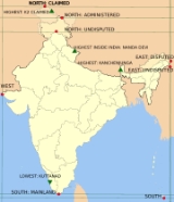
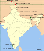
Extreme points of India
Encyclopedia
India
India , officially the Republic of India , is a country in South Asia. It is the seventh-largest country by geographical area, the second-most populous country with over 1.2 billion people, and the most populous democracy in the world...
; and the highest and the lowest altitudes in the country. Also included in this list is the southern-most Indian station in Antarctica. The northern-most and eastern-most points claimed by India are both in territory disputed between India and the People's Republic of China
People's Republic of China
China , officially the People's Republic of China , is the most populous country in the world, with over 1.3 billion citizens. Located in East Asia, the country covers approximately 9.6 million square kilometres...
. With the exception of Kanyakumari
Kanyakumari
Kanyakumari is a town in the state of Tamil Nadu in India. It is also sometimes referred to as Cape Comorin. Located at the southernmost tip of the Indian Peninsula, it is the geographical end of the Indian mainland. The district in Tamil Nadu where the town is located is called Kanyakumari...
(Cape Comorin), the southern-most location of mainland India, all other extreme locations are uninhabited.
The latitude and longitude are expressed in decimal degree notation, in which a positive latitude value refers to the northern hemisphere, and a negative value refers to the southern hemisphere. Similarly, a positive longitude value refers to the eastern hemisphere, and a negative value refers to the western hemisphere. The coordinates used in this article are sourced from Google Earth
Google Earth
Google Earth is a virtual globe, map and geographical information program that was originally called EarthViewer 3D, and was created by Keyhole, Inc, a Central Intelligence Agency funded company acquired by Google in 2004 . It maps the Earth by the superimposition of images obtained from satellite...
, which makes use of the WGS84
World Geodetic System
The World Geodetic System is a standard for use in cartography, geodesy, and navigation. It comprises a standard coordinate frame for the Earth, a standard spheroidal reference surface for raw altitude data, and a gravitational equipotential surface that defines the nominal sea level.The latest...
geodetic reference system. Additionally, a negative altitude value refers to land below sea level.
Extreme points
The northern-most point that India claims lies in territory now administered by China as part of XinjiangXinjiang
Xinjiang is an autonomous region of the People's Republic of China. It is the largest Chinese administrative division and spans over 1.6 million km2...
but once claimed by Hunza
Hunza
Hunza may refer to*Hunza Valley*Former State of Hunza*Hunza River*Hunza Peak*Hunza people*Hunza is the Muisca name of the city of Tunja, Colombia...
and therefore claimed by India as part of the disputed state of Kashmir
Kashmir
Kashmir is the northwestern region of the Indian subcontinent. Until the mid-19th century, the term Kashmir geographically denoted only the valley between the Great Himalayas and the Pir Panjal mountain range...
. The northern-most point administered by India lies in Kashmir. India's claim to the whole of Kashmir is disputed by Pakistan and China, with the territory currently partitioned into Pakistan-occupied Kashmir, Chinese occupied Aksai Chin
Aksai Chin
Aksai Chin is one of the two main disputed border areas between China and India, and the other is South Tibet, which comprises most of India's Arunachal Pradesh. It is administered by China as part of Hotan County in the Hotan Prefecture of Xinjiang Autonomous Region, but is also claimed by India...
and the Indian-administered state of Jammu and Kashmir
Jammu and Kashmir
Jammu and Kashmir is the northernmost state of India. It is situated mostly in the Himalayan mountains. Jammu and Kashmir shares a border with the states of Himachal Pradesh and Punjab to the south and internationally with the People's Republic of China to the north and east and the...
. This list provides the northern-most point as claimed by India; the northern-most disputed point that is administered by India; and the northern-most undisputed point in India. This case also applies to the highest elevated regions.
India's eastern-most state is Arunachal Pradesh
Arunachal Pradesh
Arunachal Pradesh is a state of India, located in the far northeast. It borders the states of Assam and Nagaland to the south, and shares international borders with Burma in the east, Bhutan in the west, and the People's Republic of China in the north. The majority of the territory is claimed by...
. Part of the state is claimed by China, though administered by India, The eastern-most of Indian-administered territory is located in this disputed region. Consequently, this list mentions both the disputed and undisputed eastern-most points in India.
| Heading | Location | Administrative entity | Bordering entity | CoordinatesCoordinates obtained from Google Earth Google Earth Google Earth is a virtual globe, map and geographical information program that was originally called EarthViewer 3D, and was created by Keyhole, Inc, a Central Intelligence Agency funded company acquired by Google in 2004 . It maps the Earth by the superimposition of images obtained from satellite... . Google Earth makes use of the WGS84 World Geodetic System The World Geodetic System is a standard for use in cartography, geodesy, and navigation. It comprises a standard coordinate frame for the Earth, a standard spheroidal reference surface for raw altitude data, and a gravitational equipotential surface that defines the nominal sea level.The latest... geodetic reference system. |
Ref |
|---|---|---|---|---|---|
| North (disputed, administered) |
Karakoram Pass Karakoram Pass The Karakoram Pass is a mountain pass between India and China in the Karakoram Range. It is the highest pass on the ancient caravan route between Leh in Ladakh and Yarkand in the Tarim Basin... , near the Siachen Glacier Siachen Glacier The Siachen Glacier is located in the eastern Karakoram range in the Himalaya Mountains at about , just east of the Line of Control between India-Pakistan. India controls all of the Siachen Glacier itself, including all tributary glaciers. At long, it is the longest glacier in the Karakoram and... |
Indian-administered Kashmir | Xinjiang Xinjiang Xinjiang is an autonomous region of the People's Republic of China. It is the largest Chinese administrative division and spans over 1.6 million km2... , People's Republic of China People's Republic of China China , officially the People's Republic of China , is the most populous country in the world, with over 1.3 billion citizens. Located in East Asia, the country covers approximately 9.6 million square kilometres... |
35.51769°N 77.81410°W | |
| North (disputed, claimed) |
Dafdar Dafdar Dafdar or Daftar is a village in the Taghdumbash Pamir located in Tashkurgan Tajik Autonomous County, Xinjiang Uyghur Autonomous Region, China. It is inhabited by Wakhis... in the Taghdumbash Pamir Taghdumbash Pamir Taghdumbash Pamir is a pamir or high valley in the south west of Tashkurgan Tajik Autonomous County, in the Xinjiang Uyghur Autonomous Region in China. It lies to the west of the Karakoram Highway... near Beyik Pass Beyik Pass The Beyik Pass, also written Payik Pass, is a mountain pass in the Sarikol Range between Gorno-Badakhshan Autonomous Province in Tajikistan and the Tashkurgan Tajik Autonomous County in Xinjiang, China. It is at an elevation of . There is no road across the pass.- References :... |
Xinjiang Xinjiang Xinjiang is an autonomous region of the People's Republic of China. It is the largest Chinese administrative division and spans over 1.6 million km2... , People's Republic of China People's Republic of China China , officially the People's Republic of China , is the most populous country in the world, with over 1.3 billion citizens. Located in East Asia, the country covers approximately 9.6 million square kilometres... |
Wakhan Corridor Wakhan Corridor Wakhan Corridor is commonly used as a synonym for Wakhan, an area of far north-eastern Afghanistan which forms a land link or "corridor" between Afghanistan and China. The Corridor is a long and slender panhandle or salient, roughly long and between wide. It separates Tajikistan in the north... , Badakhshan Province Badakhshan Province Badakhshan is one of the 34 provinces of Afghanistan, consisting of 28 districts. It is located in the north-east of the country, between the Hindu Kush and the Amu Darya. It is part of the Badakhshan region.-Geography:... , Afghanistan Afghanistan Afghanistan , officially the Islamic Republic of Afghanistan, is a landlocked country located in the centre of Asia, forming South Asia, Central Asia and the Middle East. With a population of about 29 million, it has an area of , making it the 42nd most populous and 41st largest nation in the world... |
37°24′00"N 75°24′00"E | |
| North (undisputed) |
Near Dharwas Dharwas Dharwas is the northernmost town in Himachal Pradesh in Chamba district.Dharwas is located in the Pangi Valley, on the Dalhousie-Kishtwar trek route. Pangi Valley is the remotest valley of Chamba district, and according to Dr. Hutchison, “unique in its grandeur and beauty.” Dharwas is the largest... , Chamba district Chamba district Chamba is the northwestern district of Himachal Pradesh, in India, with its headquarters in Chamba town. The towns of Dalhousie and Khajjhiar are popular hill stations and vacation spots for the people from the plains of northern India.... |
Himachal Pradesh Himachal Pradesh Himachal Pradesh is a state in Northern India. It is spread over , and is bordered by the Indian states of Jammu and Kashmir on the north, Punjab on the west and south-west, Haryana and Uttar Pradesh on the south, Uttarakhand on the south-east and by the Tibet Autonomous Region on the east... |
Indian-administered Kashmir | 33.24902°N 76.82704°W | |
| South | Indira Point Indira Point Indira Point is situated on the island of Great Nicobar in the Nicobar Islands, eastern Indian Ocean, and it represents the southernmost point of land in the territory of India. The point is located in the Union Territory of Andaman and Nicobar Islands and is named in honour of Indira Gandhi... in the Nicobar Islands Nicobar Islands The Nicobar Islands are an archipelagic island chain in the eastern Indian Ocean... |
Andaman and Nicobar Islands | Indian Ocean Indian Ocean The Indian Ocean is the third largest of the world's oceanic divisions, covering approximately 20% of the water on the Earth's surface. It is bounded on the north by the Indian Subcontinent and Arabian Peninsula ; on the west by eastern Africa; on the east by Indochina, the Sunda Islands, and... |
6.74678°N 93.84260°W | |
| South (mainland) | Cape Comorin near Kanyakumari | Tamil Nadu Tamil Nadu Tamil Nadu is one of the 28 states of India. Its capital and largest city is Chennai. Tamil Nadu lies in the southernmost part of the Indian Peninsula and is bordered by the union territory of Pondicherry, and the states of Kerala, Karnataka, and Andhra Pradesh... |
Indian Ocean Indian Ocean The Indian Ocean is the third largest of the world's oceanic divisions, covering approximately 20% of the water on the Earth's surface. It is bounded on the north by the Indian Subcontinent and Arabian Peninsula ; on the west by eastern Africa; on the east by Indochina, the Sunda Islands, and... |
8.06890°N 77.55230°W | |
| South (Antarctica) | Maitri Maitri Maitri is India's second permanent research station in Antarctica. It was built and finished in 1989, shortly before the first station Dakshin Gangotri was buried in ice and abandoned in 1990-91... in the Schirmacher Oasis Schirmacher Oasis The Schirmacher Oasis is a 25 km long and up to 3 km wide ice-free plateau with more than 100 fresh water lakes. It is situated in the Schirmacher Hills on the Princess Astrid Coast in Queen Maud Land in East Antarctica, and is on average 100 metres above sea level... area |
Antarctica | N/A | 70.76583°N 11.73583°W | |
| East (disputed, administered) |
Kibithu Kibithu Kibithu is a town in Arunachal Pradesh in Anjaw district. It is one of the easternmost permanently town of India, located on the LAC at . It is located on the last road head of extreme northeast of northeastern India. The Lohit River enters India at Kibithu.It is amongst the most beautiful town... in Anjaw district Anjaw district Anjaw District is an administrative district in the state of Arunachal Pradesh in north-east India. It is a newly created district, having been split from Lohit district on 16 February 2004 under The Arunachal Pradesh Re-organization of Districts Amendment Bill. The district borders China on the... |
Arunachal Pradesh Arunachal Pradesh Arunachal Pradesh is a state of India, located in the far northeast. It borders the states of Assam and Nagaland to the south, and shares international borders with Burma in the east, Bhutan in the west, and the People's Republic of China in the north. The majority of the territory is claimed by... |
Tibet Tibet Autonomous Region The Tibet Autonomous Region , Tibet or Xizang for short, also called the Xizang Autonomous Region is a province-level autonomous region of the People's Republic of China , created in 1965.... , People's Republic of China People's Republic of China China , officially the People's Republic of China , is the most populous country in the world, with over 1.3 billion citizens. Located in East Asia, the country covers approximately 9.6 million square kilometres... |
28.01744°N 97.40238°W | |
| East (undisputed) | Near Kumki, in the Changlang district Changlang District Changlang district is located in the Indian state of Arunachal Pradesh, located south of Lohit district and north of Tirap district. As of 2011 it is the second most populous district of Arunachal Pradesh , after Papum Pare.-Post-independence:... |
Arunachal Pradesh Arunachal Pradesh Arunachal Pradesh is a state of India, located in the far northeast. It borders the states of Assam and Nagaland to the south, and shares international borders with Burma in the east, Bhutan in the west, and the People's Republic of China in the north. The majority of the territory is claimed by... |
Kachin State Kachin State Kachin State , is the northernmost state of Burma. It is bordered by China to the north and east; Shan State to the south; and Sagaing Division and India to the west. It lies between north latitude 23° 27' and 28° 25' longitude 96° 0' and 98° 44'. The area of Kachin State is . The capital of the... , Myanmar Myanmar Burma , officially the Republic of the Union of Myanmar , is a country in Southeast Asia. Burma is bordered by China on the northeast, Laos on the east, Thailand on the southeast, Bangladesh on the west, India on the northwest, the Bay of Bengal to the southwest, and the Andaman Sea on the south.... |
27.12622°N 97.16712°W | |
| West | Ghuar Mota Ghuar Mota Ghuar Mota is the western-most inhabited village in India, in Kutch district in Gujarat at . It is located near the disputed Sir Creek.... in Kutch, near the Sir Creek Sir Creek The Sir Creek is a 96 km strip of water disputed between India and Pakistan in the Rann of Kutch marshlands. The creek, which opens up into the Arabian Sea, divides the Kutch region of the Indian state of Gujarat with the Sindh province of Pakistan. It is located at approximately .Originally... |
Gujarat | Arabian Sea Arabian Sea The Arabian Sea is a region of the Indian Ocean bounded on the east by India, on the north by Pakistan and Iran, on the west by the Arabian Peninsula, on the south, approximately, by a line between Cape Guardafui in northeastern Somalia and Kanyakumari in India... |
23.71307°N 68.03215°W |
Extreme altitude
| Extremity | Name | Altitude | Location | State | Coordinates | Ref |
|---|---|---|---|---|---|---|
| Highest (undisputed) | Kanchenjunga | 8586 m (28,169 ft) | West Sikkim West Sikkim West Sikkim is a district of theIndian state of Sikkim. Its capital is Geyzing, also known as Gyalshing. The district is a favourite with trekkers due to the high elevations. Other important towns include Pelling and Jorethang.-History:... on the India-Nepal border |
Sikkim Sikkim Sikkim is a landlocked Indian state nestled in the Himalayan mountains... |
27.70250°N 88.14833°W | |
| Highest (disputed) | K2 K2 K2 is the second-highest mountain on Earth, after Mount Everest... |
8611 m (28,251 ft) | Border between Kashmir and Xinjiang Xinjiang Xinjiang is an autonomous region of the People's Republic of China. It is the largest Chinese administrative division and spans over 1.6 million km2... |
Northern Areas Northern Areas Gilgit-Baltistan , is the northernmost political entity within Pakistan. It borders Pakistan's Khyber Pukhtunkhwa province to the west, Afghanistan's Wakhan Corridor to the north, China to the east and northeast, Azad Kashmir to the southwest, and Indian-administered Jammu and Kashmir to the... Pakistan-Occupied Kashmir |
35.88250°N 76.51333°W | |
| Highest (completely within India) |
Nanda Devi Nanda Devi Nanda Devi is the second highest mountain in India and the highest entirely within the country ; owing to this geography it was the highest known mountain in the world until computations on Dhaulagiri by western surveyors in 1808... |
7816 m (25,643 ft) | Garhwal Himalaya | Uttarakhand Uttarakhand Uttarakhand , formerly Uttaranchal, is a state in the northern part of India. It is often referred to as the Land of Gods due to the many holy Hindu temples and cities found throughout the state, some of which are among Hinduism's most spiritual and auspicious places of pilgrimage and worship... |
30.37667°N 79.97083°W | |
| Lowest | Kuttanad Kuttanad Kuttanadu is a region in the district of Alappuzha, in the state of Kerala, India, well known for its picturesque vast paddy fields and its geographical peculiarities. It's the region with the lowest altitude in India, and one of the few places in the world where farming is carried out below sea... |
-2.2 m | Alappuzha district Alappuzha district Alappuzha is one of the 14 districts in the state of Kerala in India. It was formed as Alleppey District on August 17, 1957. The name of the district was officially changed to Alappuzha in 1990. The district is a widely known tourist destination, and is well known for its coir factories. Most of... |
Kerala Kerala or Keralam is an Indian state located on the Malabar coast of south-west India. It was created on 1 November 1956 by the States Reorganisation Act by combining various Malayalam speaking regions.... |
9.15360°N 76.47300°W |