

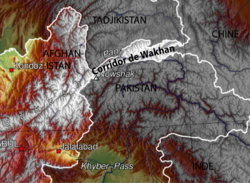
Wakhan Corridor
Encyclopedia
Wakhan
Wakhan or "the Wakhan" is a very mountainous and rugged part of the Pamir and Karakoram regions of Afghanistan. Wakhan District is a district in Badakshan Province.-Geography:...
, an area of far north-eastern Afghanistan
Afghanistan
Afghanistan , officially the Islamic Republic of Afghanistan, is a landlocked country located in the centre of Asia, forming South Asia, Central Asia and the Middle East. With a population of about 29 million, it has an area of , making it the 42nd most populous and 41st largest nation in the world...
which forms a land link or "corridor" between Afghanistan and China
China
Chinese civilization may refer to:* China for more general discussion of the country.* Chinese culture* Greater China, the transnational community of ethnic Chinese.* History of China* Sinosphere, the area historically affected by Chinese culture...
. The Corridor is a long and slender panhandle
Panhandle
A panhandle is an informal geographic term for an elongated arm-like protrusion of a geo-political entity, such as a subnational entity or a sovereign state.-Term:...
or salient, roughly 220 kilometres (136.7 mi) long and between 10 and 40 mi (16.1 and 64.4 ) wide. It separates Tajikistan
Tajikistan
Tajikistan , officially the Republic of Tajikistan , is a mountainous landlocked country in Central Asia. Afghanistan borders it to the south, Uzbekistan to the west, Kyrgyzstan to the north, and China to the east....
in the north from Pakistan
Pakistan
Pakistan , officially the Islamic Republic of Pakistan is a sovereign state in South Asia. It has a coastline along the Arabian Sea and the Gulf of Oman in the south and is bordered by Afghanistan and Iran in the west, India in the east and China in the far northeast. In the north, Tajikistan...
in the south.
The corridor was a political creation of the Great Game
The Great Game
The Great Game or Tournament of Shadows in Russia, were terms for the strategic rivalry and conflict between the British Empire and the Russian Empire for supremacy in Central Asia. The classic Great Game period is generally regarded as running approximately from the Russo-Persian Treaty of 1813...
. On the corridor's north side, agreements between Britain
United Kingdom
The United Kingdom of Great Britain and Northern IrelandIn the United Kingdom and Dependencies, other languages have been officially recognised as legitimate autochthonous languages under the European Charter for Regional or Minority Languages...
and Russia
Russia
Russia or , officially known as both Russia and the Russian Federation , is a country in northern Eurasia. It is a federal semi-presidential republic, comprising 83 federal subjects...
in 1873 and between Britain and Afghanistan in 1893 effectively split the historic area of Wakhan by making the Panj
Panj River
The Panj River , also known as Pyandzh River or Piandj River , is a tributary of the Amu Darya. The river is 1,125 km long and forms a considerable part of the Afghanistan - Tajikistan border....
and Pamir River
Pamir River
The Pamir is a river in Tajikistan and Afghanistan. It is a tributary of the Panj River, and forms the northern boundary of Wakhan.The river has its sources in the Pamir Mountains in Gorno-Badakhshan province in the far eastern part of Tajikistan. It flows between the Wakhan Range and the Southern...
s the border between Afghanistan and the Russian Empire
Russian Empire
The Russian Empire was a state that existed from 1721 until the Russian Revolution of 1917. It was the successor to the Tsardom of Russia and the predecessor of the Soviet Union...
. On its south side, the Durand Line
Durand Line
The Durand Line refers to the porous international border between Pakistan and Afghanistan, which has divided the ethnic Pashtuns . This poorly marked line is approximately long...
agreement of 1893 marked the boundary between British India and Afghanistan. This left a narrow strip of land as a buffer between the two empires, which became known as the Wakhan Corridor in the 20th century. The corridor has 12,000 inhabitants.
The term Wakhan Corridor is also used in a narrower sense to refer to the route along the Panj River
Panj River
The Panj River , also known as Pyandzh River or Piandj River , is a tributary of the Amu Darya. The river is 1,125 km long and forms a considerable part of the Afghanistan - Tajikistan border....
and the Wakhan River to China, and the northern part of the Wakhan is then referred to as the Afghan Pamir.
Geography
The Pamir RiverPamir River
The Pamir is a river in Tajikistan and Afghanistan. It is a tributary of the Panj River, and forms the northern boundary of Wakhan.The river has its sources in the Pamir Mountains in Gorno-Badakhshan province in the far eastern part of Tajikistan. It flows between the Wakhan Range and the Southern...
, flowing out of Lake Zorkul
Zorkul
Zorkul is a lake in the Pamir Mountains that runs along the border between Afghanistan and Tajikistan. It extends east to west for about 25 km. The Afghan-Tajik border runs along the lake from east to west, turning south towards Concord Peak , about 15 km south of the lake. The lake's northern...
, forms the northern border of the corridor. The Wakhan River passes through the corridor from the east to Kala-i-Panj, joining the Pamir River to become the Panj River
Panj River
The Panj River , also known as Pyandzh River or Piandj River , is a tributary of the Amu Darya. The river is 1,125 km long and forms a considerable part of the Afghanistan - Tajikistan border....
.
In the south, the corridor is bounded by the high mountains of the Hindu Kush
Hindu Kush
The Hindu Kush is an mountain range that stretches between central Afghanistan and northern Pakistan. The highest point in the Hindu Kush is Tirich Mir in the Chitral region of Khyber-Pakhtunkhwa, Pakistan.It is the westernmost extension of the Pamir Mountains, the Karakoram Range, and is a...
, crossed by the Broghol
Broghol
Broghol, also spelled Broghil, Boroghil and several other ways, is a high mountain pass that crosses the Hindu Kush and connects the Wakhan Corridor of Afghanistan with Chitral in Pakistan....
pass, the Irshad Pass
Irshad Pass
Irshad pass ; spelled also as Ershād Yūvīn, Irshad Pass, Irshad Urween, Irshād Uwin Pass, Kotale Ers̄āḏ Owīn, Kowtal-e Ershād Owīn; is a high mountain pass that connects Chapursan river valley in Gojal tehsil of Gilgit district in Gilgit-Baltistan with Wakhan Corridor in Afghanistan....
and the disused Dilisang Pass to Pakistan
Pakistan
Pakistan , officially the Islamic Republic of Pakistan is a sovereign state in South Asia. It has a coastline along the Arabian Sea and the Gulf of Oman in the south and is bordered by Afghanistan and Iran in the west, India in the east and China in the far northeast. In the north, Tajikistan...
.
At the eastern border, the Wakhjir Pass
Wakhjir Pass
The Wakhjir Pass is a mountain pass in the Hindu Kush or Pamirs at the eastern end of the Wakhan Corridor, the only pass between Afghanistan and China. It links Wakhan in Afghanistan with the Tashkurgan Tajik Autonomous County in Xinjiang, China, at an altitude of 4,923 m, but the pass is not an...
through the Hindu Kush at 4923 m (16,151.6 ft), is one of the highest in the world. The Wakhjir Pass
Wakhjir Pass
The Wakhjir Pass is a mountain pass in the Hindu Kush or Pamirs at the eastern end of the Wakhan Corridor, the only pass between Afghanistan and China. It links Wakhan in Afghanistan with the Tashkurgan Tajik Autonomous County in Xinjiang, China, at an altitude of 4,923 m, but the pass is not an...
has the greatest official change of clocks of any international frontier (UTC+4:30
UTC+4:30
UTC+04:30 is an identifier for a time offset from UTC of +04:30. This time is used in:-As daylight saving time :*Iran...
in Afghanistan to UTC+8
UTC+8
UTC+08:00 is an identifier for a time offset from UTC of +08:00. In ISO 8601 the associated time would be written as .With an estimated population of 1.53 billion living within the time zone, roughly 22.5% of the world population, it is the most populous time zone in world, as well as a possible...
, China Standard Time, in China).
The Corridor as a through route
Although the terrain is extremely rugged, the Corridor was historically used as a trading route between BadakhshanBadakhshan
Badakhshan is an historic region comprising parts of what is now northeastern Afghanistan and southeastern Tajikistan. The name is retained in Badakhshan Province which is one of the thirty-four provinces of Afghanistan, in the far northeast of Afghanistan, and contains the Wakhan Corridor...
and Yarkand
Yarkand
Yarkant County , is a county in Xinjiang Uyghur Autonomous Region, China, located on the southern rim of the Taklamakan desert in the Tarim Basin. It is one of 11 counties administered under Kashgar Prefecture...
. It appears that Marco Polo
Marco Polo
Marco Polo was a Venetian merchant traveler from the Venetian Republic whose travels are recorded in Il Milione, a book which did much to introduce Europeans to Central Asia and China. He learned about trading whilst his father and uncle, Niccolò and Maffeo, travelled through Asia and apparently...
came this way. The Portuguese Jesuit priest Bento de Goes
Bento de Goes
Bento de Góis , was a Portuguese Jesuit Brother, Missionary and explorer...
crossed from the Wakhan to China between 1602 and 1606. In May 1906 Sir Aurel Stein explored the Wakhan, and reported that at that time 100 pony loads of goods crossed annually to China.
Early travellers used one of three routes:
- A northern route led up the valley of the Pamir River to Zorkul lake, then east through the mountains to the valley of the Murghab River, then across the Sarikol RangeSarikol RangeThe Sarikol Range is a mountain range in the Pamirs on the border of Tajikistan and the People’s Republic of China. The range divides Tajikistan's Gorno-Badakhshan Autonomous Province and China's Xinjiang Uyghur Autonomous Region and it runs parallel with the Muztagh Range to the east. The range...
to China. - A southern route led up the valley of the Wakhan River to the Wakhjir Pass to China. This pass is closed for at least five months a year and is only open irregularly for the remainder.
- A central route branched off the southern route through the Little PamirLittle PamirThe Little Pamir is a broad U-shaped grassy valley or pamir in the eastern part of the Wakhan in north-eastern Afghanistan...
to the Murghab River valley.
As a through route the Corridor has been closed to regular traffic for over 100 years. There is no modern road through the Corridor. There is a rough road from Ishkashim to Sarhad-e Broghil built in the 1960s, but only paths beyond. It is some 100 km from the road end to the Chinese border at Wakhjir Pass, and further to the far end of the Little Pamir.
Townsend (2005) discusses the possibility of drug smuggling from Afghanistan to China via Wakhan Corridor and Wakhjir Pass, but concludes that, due to the difficulties of travel and border crossings, even if such trafficking occurs, it is minor compared to that conducted via Tajikistan
Tajikistan
Tajikistan , officially the Republic of Tajikistan , is a mountainous landlocked country in Central Asia. Afghanistan borders it to the south, Uzbekistan to the west, Kyrgyzstan to the north, and China to the east....
's Gorno-Badakhshan Autonomous Province
Gorno-Badakhshan Autonomous Province
Gorno-Badakhshan Autonomous Province is an autonomous, mountainous province in the east of Tajikistan. Located in the Pamir Mountains, it makes up 45% of the land area of the country but only 3% of the population....
or even via Pakistan, both having much more accessible routes into China.
Afghanistan has asked China
People's Republic of China
China , officially the People's Republic of China , is the most populous country in the world, with over 1.3 billion citizens. Located in East Asia, the country covers approximately 9.6 million square kilometres...
on several occasions to open the border in the Wakhan Corridor for economic reasons, or as an alternative supply route for fighting the Taliban insurgency
Taliban insurgency
The Taliban insurgency took root shortly after the group's fall from power following the 2001 war in Afghanistan. The Taliban continue to attack Afghan, U.S., and other ISAF troops and many terrorist incidents attributable to them have been registered. The war has also spread over the southern and...
. However China has resisted, largely due to unrest in its far western province of Xinjiang
Xinjiang
Xinjiang is an autonomous region of the People's Republic of China. It is the largest Chinese administrative division and spans over 1.6 million km2...
which borders the corridor. In December 2009 it was reported that the United States
United States
The United States of America is a federal constitutional republic comprising fifty states and a federal district...
had asked China to open the Corridor.
Books
- M. Nazif Mohib Shahrani, The Kirghiz and Wakhi of Afghanistan: Adaptation to Closed Frontiers and War. University of Washington Press, 2002. ISBN 0-295-98262-4.
External links
- CIA Relief Map
- Wakhan Development Partnership A project working to improve the lives of the people of Wakhan since 2003
- A Short Walk in the Wakhan Corridor Article by Mark Jenkins in the November 2005 issue of Outside magazine.