
Darling Downs, Queensland
Encyclopedia
The Darling Downs is a farm
ing region on the western slopes of the Great Dividing Range
in southern Queensland
, Australia
. The Downs are to the west of South East Queensland
and are one of eleven major regions of Queensland
.
The region was named after the then Governor of New South Wales, Ralph Darling
by Allan Cunningham
, an early Australian explorer.
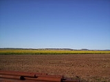
The landscape
is dominated by rolling hills covered by pastures of many different vegetable
s, legumes and other crops including cotton
, wheat
, barley
and sorghum
. Between the farmlands there are long stretches of crisscrossing roads, bushy
ridges, winding creeks and herds of cattle. There are farms with beef
and dairy cattle
, pig
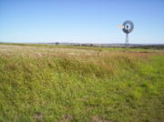
s, sheep and lamb
stock. Other typical sights include irrigation
systems, windmills serving as water well
pumps to get water from the Great Artesian Basin
, light planes crop
-dusting, rusty old woolsheds and other scattered remnants from a bygone era of early exploration and settlement.
about 132 km west of Brisbane
.
Other towns situated on what is now called the Downs include Dalby
, Warwick
, Roma
, Oakey
, Mitchell
, Pittsworth
, Allora
, Clifton
, Cecil Plains
, Drayton
, Millmerran
, Nobby
, and Chinchilla
in the west.
 The Darling Down is situated in the drainage basins of the Condamine River
and Maranoa River
and tributaries. On the northern boundaries of the Downs are the Bunya Mountains
and the Bunya Mountains National Park
. The region to the north is the South Burnett
and the Maranoa
lies to the west. A section of the western downs lies over coal deposits of the Surat Basin
. Towards the coast, the mountains of the Scenic Rim
form the headwaters of the westward flowing Condamine.
. The phrase is also used to define political boundaries and in the promotion of tourism in the area. The Dumaresq
and the MacIntyre
are found in this part of the region.
area. Murri is wider spread genic word meaning the whole race but in the Kamabroi dialect. The Downs tribes spoke one common dialect, called Waccah and so to all other surrounding tribes were known as the Wacca-burra. The Goonnee-burra were once situated where Warwick stands today.
 Cunninghams Gap and the Darling Downs were first explored by Allan Cunningham
and Charles Fraser
in 1827. Cunningham returned in 1828 to further research the area and try to find a way through to the coast which was still off limits being a penal colony. Cunningham climbed to the top of Mount Dumareque (near what is now Maryvale
) and after wrote in his diary that this lush area was ideal for settlement. The original Darling Downs as quoted by Allan Cunningham was named after Governor Darling and stretched for 100 miles or as far as the eye could see from Mt Dumaresque. Ludwig Leichhardt
in 1844 saw the remains of a camp showing the signs of white men through ridge polls and steel axes.
News of the lush pastures quickly spread resulting in a land grab that authorities in the distant New South Wales colony found difficult to stop. Patrick Leslie
was the first person to settle on the Darling Downs in 1840, establishing a sheep property at Canning Downs
on the Condamine River
in 1846. Other well-established residences on the southern downs include Glengallan Homestead, Talgai Homestead, Pringle Cottage and Rosenthal Homestead.
In 1854 Charles Douglas Eastaughffe
settled in the area. Spicers Gap Road opened up the area in the 1850s. Later the expansion of Queensland Rail
's train networks and Cobb and Co
's stagecoach
transport greatly assisted access to the region. Gold
was found in the district around this time, however it was agricultural activity that provided for the boom times ahead.
The 1891 Australian shearers' strike
started at Jondaryan. The Darling Downs experienced a water crisis
as the Condamine River dried up during the severe drought of 1994/1995.
, Gore Highway
and the Warrego Highway
traverse the region. The Leslie Dam
, Storm King Dam
and the Glenlyon Dam
are some of the major water storage facilities in the area.
The Queensland Gas Pipeline oil pipeline and the Roma to Brisbane Pipeline, Australia's first natural gas pipeline both cross the region from west to east. There are a few coal mines and a number of power stations situated on the Downs, including the Millmerran Power Station, Oakey Power Station, Darling Downs Power Station]] and the Kogan Creek Power Station.
Before European settlement many areas on the Darling Downs were fertile wilderness
. For example around Ma Ma Creek, rich swamp
y wetlands provided a haven for many animal species not currently found on the downs. The Hopping mouse
and Paradise Parrot
have both become extinct since cattle farming begun.
The Dingo Fence
starts at the town of Jimbour
across the country to the Great Australian Bight
.
near Killarney
in the Main Range National Park
. Lake Broadwater is the only natural lake on the tablelands.
 The town of Jandowae
gained fame after offering vacant block of land for just $1. This was done to encourage resident to settle in the small town with less than 1000 people in 2001.
The Cobb & Co Museum
has displays of horse drawn vehicles and material on the history of the Darling Downs. The region has also a small zoo, Darling Downs Zoo near Clifton.
The region has uncovered important megafauna
fossil finds. The rich discoveries have lent weight to the theory that humans were not a factor in the extinction of the ancient megafauna species.
(Arthur Davis) wrote a series of comic novels on rural life, starting with On Our Selection (1899), about Dad, Mother and Dave Rudd of Snake Gully. The Rudds had four (or six) acres adjoining a sheep run in Darling Downs. They were made into films and a radio series.
Farm
A farm is an area of land, or, for aquaculture, lake, river or sea, including various structures, devoted primarily to the practice of producing and managing food , fibres and, increasingly, fuel. It is the basic production facility in food production. Farms may be owned and operated by a single...
ing region on the western slopes of the Great Dividing Range
Great Dividing Range
The Great Dividing Range, or the Eastern Highlands, is Australia's most substantial mountain range and the third longest in the world. The range stretches more than 3,500 km from Dauan Island off the northeastern tip of Queensland, running the entire length of the eastern coastline through...
in southern Queensland
Queensland
Queensland is a state of Australia, occupying the north-eastern section of the mainland continent. It is bordered by the Northern Territory, South Australia and New South Wales to the west, south-west and south respectively. To the east, Queensland is bordered by the Coral Sea and Pacific Ocean...
, Australia
Australia
Australia , officially the Commonwealth of Australia, is a country in the Southern Hemisphere comprising the mainland of the Australian continent, the island of Tasmania, and numerous smaller islands in the Indian and Pacific Oceans. It is the world's sixth-largest country by total area...
. The Downs are to the west of South East Queensland
South East Queensland
South East Queensland is a region of the state of Queensland in Australia, which contains approximately two-thirds of the state population...
and are one of eleven major regions of Queensland
Regions of Queensland
The Regions of Queensland refers to the geographic areas of the Australian state of Queensland. Due to its large size and decentralised population, the state is often divided into regions for statistical and administrative purposes. Each region varies somewhat in terms of its economy, population,...
.
The region was named after the then Governor of New South Wales, Ralph Darling
Ralph Darling
General Sir Ralph Darling, GCH was a British colonial Governor and Governor of New South Wales from 1825 to 1831.-Early career:...
by Allan Cunningham
Allan Cunningham (botanist)
Allan Cunningham was an English botanist and explorer, primarily known for his travels in New South Wales to collect plants.- Early life :...
, an early Australian explorer.
The landscape
Landscape
Landscape comprises the visible features of an area of land, including the physical elements of landforms such as mountains, hills, water bodies such as rivers, lakes, ponds and the sea, living elements of land cover including indigenous vegetation, human elements including different forms of...
is dominated by rolling hills covered by pastures of many different vegetable
Vegetable
The noun vegetable usually means an edible plant or part of a plant other than a sweet fruit or seed. This typically means the leaf, stem, or root of a plant....
s, legumes and other crops including cotton
Cotton
Cotton is a soft, fluffy staple fiber that grows in a boll, or protective capsule, around the seeds of cotton plants of the genus Gossypium. The fiber is almost pure cellulose. The botanical purpose of cotton fiber is to aid in seed dispersal....
, wheat
Wheat
Wheat is a cereal grain, originally from the Levant region of the Near East, but now cultivated worldwide. In 2007 world production of wheat was 607 million tons, making it the third most-produced cereal after maize and rice...
, barley
Barley
Barley is a major cereal grain, a member of the grass family. It serves as a major animal fodder, as a base malt for beer and certain distilled beverages, and as a component of various health foods...
and sorghum
Sorghum
Sorghum is a genus of numerous species of grasses, one of which is raised for grain and many of which are used as fodder plants either cultivated or as part of pasture. The plants are cultivated in warmer climates worldwide. Species are native to tropical and subtropical regions of all continents...
. Between the farmlands there are long stretches of crisscrossing roads, bushy
Bushland
Bushland is any area in Australia that is predominantly indigenous flora and fauna.Bushland is the term commonly used by conservation protection groups and other environmental groups as a blanket term for natural vegetation, which may cover any kind of habitat from open shrubby country with few...
ridges, winding creeks and herds of cattle. There are farms with beef
Beef cattle
Beef cattle are cattle raised for meat production . The meat of cattle is known as beef. When raised in a feedlot cattle are known as feeder cattle. Many such feeder cattle are born in cow-calf operations specifically designed to produce beef calves...
and dairy cattle
Dairy cattle
Dairy cattle are cattle cows bred for the ability to produce large quantities of milk, from which dairy products are made. Dairy cows generally are of the species Bos taurus....
, pig
Pig
A pig is any of the animals in the genus Sus, within the Suidae family of even-toed ungulates. Pigs include the domestic pig, its ancestor the wild boar, and several other wild relatives...
s, sheep and lamb
Domestic sheep
Sheep are quadrupedal, ruminant mammals typically kept as livestock. Like all ruminants, sheep are members of the order Artiodactyla, the even-toed ungulates. Although the name "sheep" applies to many species in the genus Ovis, in everyday usage it almost always refers to Ovis aries...
stock. Other typical sights include irrigation
Irrigation
Irrigation may be defined as the science of artificial application of water to the land or soil. It is used to assist in the growing of agricultural crops, maintenance of landscapes, and revegetation of disturbed soils in dry areas and during periods of inadequate rainfall...
systems, windmills serving as water well
Water well
A water well is an excavation or structure created in the ground by digging, driving, boring or drilling to access groundwater in underground aquifers. The well water is drawn by an electric submersible pump, a trash pump, a vertical turbine pump, a handpump or a mechanical pump...
pumps to get water from the Great Artesian Basin
Great Artesian Basin
The Great Artesian Basin provides the only reliable source of freshwater through much of inland Australia. The basin is the largest and deepest artesian basin in the world, stretching over a total of , with temperatures measured ranging from 30°C to 100°C...
, light planes crop
Crop (agriculture)
A crop is a non-animal species or variety that is grown to be harvested as food, livestock fodder, fuel or for any other economic purpose. Major world crops include maize , wheat, rice, soybeans, hay, potatoes and cotton. While the term "crop" most commonly refers to plants, it can also include...
-dusting, rusty old woolsheds and other scattered remnants from a bygone era of early exploration and settlement.
Geography
The largest city and commercial centre of the Darling Downs is ToowoombaToowoomba, Queensland
Toowoomba is a city in Southern Queensland, Australia. It is located west of Queensland's capital city, Brisbane. With an estimated district population of 128,600, Toowoomba is Australia's second largest inland city and its largest non-capital inland city...
about 132 km west of Brisbane
Brisbane
Brisbane is the capital and most populous city in the Australian state of Queensland and the third most populous city in Australia. Brisbane's metropolitan area has a population of over 2 million, and the South East Queensland urban conurbation, centred around Brisbane, encompasses a population of...
.
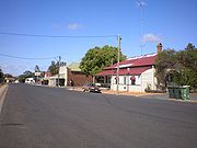
Other towns situated on what is now called the Downs include Dalby
Dalby, Queensland
Dalby is a town in the Darling Downs region of Queensland, Australia, and is located approximately west of the state capital, Brisbane, at the junction of the Warrego, Moonie and Bunya Highways. Dalby is the administrative centre of the Western Downs Region and the centre of Australia's richest...
, Warwick
Warwick, Queensland
Warwick is a town in Queensland, Australia, lying south-west of Brisbane. It is the administrative centre of the Southern Downs Local Government Area. In 2006 the town of Warwick had a population of 12,562....
, Roma
Roma, Queensland
Roma is a town in the western Darling Downs area of Queensland, Australia, by rail WNW of Brisbane. It is situated at the junction of the Warrego and Carnarvon highways...
, Oakey
Oakey, Queensland
Oakey is a rural town situated in the Darling Downs region of Queensland, Australia. It is situated west of the state capital, Brisbane, and west of the regional city of Toowoomba. At the 2006 census, Oakey had a population of 3,657.-History:...
, Mitchell
Mitchell, Queensland
Mitchell is a town in the Western Downs region of Queensland, Australia. It is on the Warrego Highway, 587 kilometres west of Brisbane and 176 kilometres east of Charleville. At the 2006 census, Mitchell had a population of 944....
, Pittsworth
Pittsworth, Queensland
Pittsworth is a town located in the Darling Downs region of southern Queensland, Australia.-Location:Located 169 km south-west of Brisbane via the Warrego Highway, 41 km south-west of Toowoomba and 518 m above sea-level, Pittsworth presents itself to the world as a town with lots of interesting...
, Allora
Allora, Queensland
Allora is a town in south-western Queensland, Australia, on the Darling Downs 158 km south-west of the state capital, Brisbane. The town is in the Southern Downs Region. The township is located on the New England Highway between Warwick and Toowoomba...
, Clifton
Clifton, Queensland
Clifton is a town in the Darling Downs region of Queensland, Australia. The lands around the town was first settled by Europeans in 1840. At the 2006 census, Clifton had a population of 1,067....
, Cecil Plains
Cecil Plains, Queensland
Cecil Plains is a town in the Darling Downs region of Queensland, Australia.The town is located in the Toowoomba Region, 217 kilometres west of the state capital, Brisbane. At the 2006 census, Cecil Plains had a population of 236...
, Drayton
Drayton, Queensland
Drayton is an outer southwestern suburb of Toowoomba, Queensland, Australia. Its Local Government Area is the Toowoomba Region.The first substantial settlement on the Darling Downs in c.1842...
, Millmerran
Millmerran, Queensland
Millmerran is a town in the Darling Downs region of Queensland, Australia. The town is situated on the Gore Highway, 208 kilometres west of the state capital, Brisbane...
, Nobby
Nobby, Queensland
Nobby is a small village on the Darling Downs, Queensland. It is located halfway between Toowoomba and Warwick. At the 2006 census, Nobby had a population of 391....
, and Chinchilla
Chinchilla, Queensland
Chinchilla is a town in the Darling Downs region of Queensland, Australia. At the 2006 census, Chinchilla had a population of 3,681.The town was established in 1877...
in the west.
Condamine River
The Condamine River, part of the Murray-Darling Basin, drains the northern portion of the Darling Downs, an area of sub-coastal southern Queensland, Australia...
and Maranoa River
Maranoa River
The Maranoa River is a large river situated in south west Queensland. The Maranoa passes through Mitchell and flows south towards St George. It is a tributary of the Balonne River which eventually flows into the Darling River , so it contributes to the Murray-Darling Basin.The river rises on the...
and tributaries. On the northern boundaries of the Downs are the Bunya Mountains
Bunya Mountains
The Bunya Mountains are a distinctive set of peaks forming an isolated section of the Great Dividing Range in southern Queensland. The mountain range forms the northern edge of the Darling Downs near Bell and Dalby. The mountains are south of Kingaroy and just to the south west of Nanango...
and the Bunya Mountains National Park
Bunya Mountains National Park
Bunya Mountains is a national park in Queensland, Australia. The park includes much of the mountain range called the Bunya Mountains. The mountains are covered by the most westerly forests in southern Queensland and the largest area of bunya pines remaining in the world...
. The region to the north is the South Burnett
South Burnett
The South Burnett is a peanut growing and wine-producing region on the Great Dividing Range, north of the Darling Downs, in Queensland.-Towns:...
and the Maranoa
Maranoa, Queensland
The Maranoa is the name given to an area of southern Queensland. Some refer to the Maranoa as the Western Downs. The Maranoa is an eastern part of the larger, mostly arid South West region of Queensland...
lies to the west. A section of the western downs lies over coal deposits of the Surat Basin
Surat Basin
The Surat Basin is a part of the Great Artesian Basin of Australia. The Surat Basin extends across an area of 270,000 square kilometres and the southern third of the basin occupies a large part of northern New South Wales, the remainder is in Queensland. It comprises Jurassic through to Cretaceous...
. Towards the coast, the mountains of the Scenic Rim
Scenic Rim
The Scenic Rim is a group of forested mountain ranges of the Great Dividing Range straddling the border between south-eastern Queensland and north-eastern New South Wales, Australia.-Description:...
form the headwaters of the westward flowing Condamine.
Southern Downs
Part of the Darling Downs, which includes the towns of Allora, Clifton, Warwick, Killarney and the rocky district in the south known as the Granite Belt, is known as the Southern Downs. The Southern Downs is classed as a region of the Interim Biogeographic Regionalisation for AustraliaInterim Biogeographic Regionalisation for Australia
The Interim Biogeographic Regionalisation for Australia is a biogeographic regionalisation of Australia developed by the Australian Government's Department of the Environment, Water, Heritage and the Arts...
. The phrase is also used to define political boundaries and in the promotion of tourism in the area. The Dumaresq
Dumaresq River
The Dumaresq River forms part of the border between Queensland and New South Wales. The Severn River is its principal tributary and the Dumaresq in turn is a tributary of the Macintyre River...
and the MacIntyre
MacIntyre River
The Macintyre River is a river in northern New South Wales, Australia, part of which forms the border with Queensland.The headwaters of the Macintyre River rise west of Guyra and south of Glen Innes on the Northern Tablelands...
are found in this part of the region.
History
Originally the Darling Downs was covered with a wealth of indigenous grasses, this created an ideal verdure for stock eight months of the year. The Darling Downs Aborigines had an annual burning season at the time when the indigenous grasses were ripe and dry. The annual fires gave the local Aborigines of the Darling Downs a name "Goonneeburra" or "Fire Blacks" - "goonnee" being a name for fire and "burra" a generic word for the whole race. This is what the Downs tribes were known as to the coast blacks who inhabited the Moreton BayMoreton Bay
Moreton Bay is a bay on the eastern coast of Australia 45 km from Brisbane, Queensland. It is one of Queensland's most important coastal resources...
area. Murri is wider spread genic word meaning the whole race but in the Kamabroi dialect. The Downs tribes spoke one common dialect, called Waccah and so to all other surrounding tribes were known as the Wacca-burra. The Goonnee-burra were once situated where Warwick stands today.
Allan Cunningham (botanist)
Allan Cunningham was an English botanist and explorer, primarily known for his travels in New South Wales to collect plants.- Early life :...
and Charles Fraser
Charles Fraser (botanist)
Charles Fraser or Frazer was Colonial Botanist of New South Wales from 1821 to 1831. He collected and catalogued numerous Australian plant species, and participated in a number of exploring expeditions...
in 1827. Cunningham returned in 1828 to further research the area and try to find a way through to the coast which was still off limits being a penal colony. Cunningham climbed to the top of Mount Dumareque (near what is now Maryvale
Maryvale, Queensland
Maryvale is a town in the Darling Downs region of Queensland, Australia. The town is located in the Southern Downs Region local government area and on the Cunningham Highway, south west of the state capital, Brisbane. At the 2006 census, Maryvale and the surrounding area had a population of 567....
) and after wrote in his diary that this lush area was ideal for settlement. The original Darling Downs as quoted by Allan Cunningham was named after Governor Darling and stretched for 100 miles or as far as the eye could see from Mt Dumaresque. Ludwig Leichhardt
Ludwig Leichhardt
Friedrich Wilhelm Ludwig Leichhardt, known as Ludwig Leichhardt, was a Prussian explorer and naturalist, most famous for his exploration of northern and central Australia.-Early life:...
in 1844 saw the remains of a camp showing the signs of white men through ridge polls and steel axes.
News of the lush pastures quickly spread resulting in a land grab that authorities in the distant New South Wales colony found difficult to stop. Patrick Leslie
Patrick Leslie
Patrick Leslie was a Scottish Settler in Australia. Leslie and his two brothers were the first to settle on the Darling Downs, and he was the first person to buy land in Warwick.-Early life:...
was the first person to settle on the Darling Downs in 1840, establishing a sheep property at Canning Downs
Canning Downs
Canning Downs was the first residential establishment built by a white person on the Darling Downs in Queensland, Australia. It is located a short drive from the town of Warwick and originally extended south east to Killarney and the McPherson Range...
on the Condamine River
Condamine River
The Condamine River, part of the Murray-Darling Basin, drains the northern portion of the Darling Downs, an area of sub-coastal southern Queensland, Australia...
in 1846. Other well-established residences on the southern downs include Glengallan Homestead, Talgai Homestead, Pringle Cottage and Rosenthal Homestead.
In 1854 Charles Douglas Eastaughffe
Charles Douglas Eastaughffe
Charles Douglas Eastaughffe was an early Australian settler, later becoming a police trooper and Chief Constable of Dalby, Queensland.Born in Inverness, Scotland c1804, it is unclear when he first arrived in Australia but it seems to have been about 1835, spending time in Sydney where he married in...
settled in the area. Spicers Gap Road opened up the area in the 1850s. Later the expansion of Queensland Rail
Queensland Rail
Queensland Rail, also known as QR, is a government-owned railway operator in the state of Queensland. Under the control of the Queensland Government, Queensland Rail operates the inner-city and long-distance passenger services, as well as some freight operations and gives railway access to other...
's train networks and Cobb and Co
Cobb and Co
Cobb and Co is the name of a transportation company in Australia. It was prominent in the late 19th century when it operated stagecoaches to many areas in the outback and at one point in several other countries, as well....
's stagecoach
Stagecoach
A stagecoach is a type of covered wagon for passengers and goods, strongly sprung and drawn by four horses, usually four-in-hand. Widely used before the introduction of railway transport, it made regular trips between stages or stations, which were places of rest provided for stagecoach travelers...
transport greatly assisted access to the region. Gold
Gold
Gold is a chemical element with the symbol Au and an atomic number of 79. Gold is a dense, soft, shiny, malleable and ductile metal. Pure gold has a bright yellow color and luster traditionally considered attractive, which it maintains without oxidizing in air or water. Chemically, gold is a...
was found in the district around this time, however it was agricultural activity that provided for the boom times ahead.
The 1891 Australian shearers' strike
1891 Australian shearers' strike
350px|thumb|Shearers' strike camp, Hughenden, central Queensland, 1891.The 1891 shearers' strike is one of Australia's earliest and most important industrial disputes. Working conditions for sheep shearers in 19th century Australia weren't good. In 1891 wool was one of Australia's largest industries...
started at Jondaryan. The Darling Downs experienced a water crisis
Water crisis
Water crisis is a general term used to describe a situation where the available water within a region is less than the region's demand. The term has been used to describe the availability of potable water in a variety of regions by the United Nations and other world organizations...
as the Condamine River dried up during the severe drought of 1994/1995.
Development
The New England HighwayNew England Highway
The New England Highway is a highway in Australia running from Hexham near Newcastle at its southern end to Yarraman near Toowoomba at its northern end. At its southern end it connects to the Pacific Highway and at its northern end it connects to the D'Aguilar Highway. It traverses the Hunter...
, Gore Highway
Gore Highway
Gore Highway is a highway in Queensland running from Goondiwindi to Toowoomba. Together with Goulburn Valley Highway and Newell Highway, it is a part of the National Highway's Melbourne-Brisbane link. It is signed as ....
and the Warrego Highway
Warrego Highway
The Warrego Highway is located in southern Queensland, Australia. It connects coastal centres to the south western areas of the state, and is approximately 750 km in length. It takes its name from the Warrego River, which is the endpoint of the highway...
traverse the region. The Leslie Dam
Leslie Dam
Leslie Dam is located ten kilometres from Warwick Central Business District in Queensland, Australia. Freshwater fishing and water sports facilities are available....
, Storm King Dam
Storm King Dam
Situated just a few kilometers from Stanthorpe, Queensland. Storm King Dam offers some good angling opportunities for Murray Cod, Yellowbelly & Silver Perch....
and the Glenlyon Dam
Glenlyon Dam
Glenlyon Dam, also known as Pike Creek Reservoir, is in Queensland near the border with New South Wales, roughly between Stanthorpe and Texas to the west...
are some of the major water storage facilities in the area.
The Queensland Gas Pipeline oil pipeline and the Roma to Brisbane Pipeline, Australia's first natural gas pipeline both cross the region from west to east. There are a few coal mines and a number of power stations situated on the Downs, including the Millmerran Power Station, Oakey Power Station, Darling Downs Power Station]] and the Kogan Creek Power Station.
Before European settlement many areas on the Darling Downs were fertile wilderness
Wilderness
Wilderness or wildland is a natural environment on Earth that has not been significantly modified by human activity. It may also be defined as: "The most intact, undisturbed wild natural areas left on our planet—those last truly wild places that humans do not control and have not developed with...
. For example around Ma Ma Creek, rich swamp
Swamp
A swamp is a wetland with some flooding of large areas of land by shallow bodies of water. A swamp generally has a large number of hammocks, or dry-land protrusions, covered by aquatic vegetation, or vegetation that tolerates periodical inundation. The two main types of swamp are "true" or swamp...
y wetlands provided a haven for many animal species not currently found on the downs. The Hopping mouse
Hopping mouse
A hopping mouse is any of about ten different Australian native mice in the genus Notomys. They are rodents, not marsupials, and their ancestors are thought to have arrived from Asia about 5 million years ago....
and Paradise Parrot
Paradise Parrot
The Paradise Parrot was a colourful medium-sized parrot native to the grassy woodlands of the Queensland - New South Wales border area of northeastern Australia. Once moderately common within its fairly restricted range, the last live bird was seen in 1927...
have both become extinct since cattle farming begun.
The Dingo Fence
Dingo Fence
The Dingo Fence or Dog Fence is a pest-exclusion fence that was built in Australia during the 1880s and finished in 1885, to keep dingoes out of the relatively fertile south-east part of the continent and protect the sheep flocks of southern Queensland. It is one of the longest structures in the...
starts at the town of Jimbour
Jimbour, Queensland
Jimbour is a town in the northern Darling Downs region of Queensland, Australia. The town is located in the Western Downs Region Local Government area, west of the state capital, Brisbane...
across the country to the Great Australian Bight
Great Australian Bight
The Great Australian Bight is a large bight, or open bay, off the central and western portions of the southern coastline of mainland Australia.-Extent:...
.
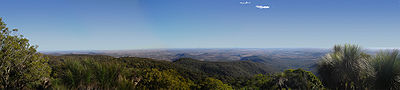
Attractions
The region is popular with tourists because of its many natural and heritage attractions, including the Goomburra State Forest, Cunninghams Gap, Spicers Gap and the Queen Mary FallsQueen Mary Falls
Queen Mary Falls are found in Main Range National Park on the McPherson Range near the New South Wales/Queensland border.The 40 m waterfall is located 50 km south-east of Warwick, 10 km east of the town of Killarney in Queensland, Australia...
near Killarney
Killarney, Queensland
Killarney is a small town located 35 km south-east of Warwick, on the Condamine River in Queensland, Australia. The town forms part of the Southern Downs local government area. Killarney is located about 8 km from the Queensland/New South Wales border. It is close to Queen Mary Falls, in the Main...
in the Main Range National Park
Main Range National Park
Main Range is a mountain range and a national park in Queensland , 85 km southwest of Brisbane. It is part of the World Heritage Site Gondwana Rainforests of Australia . It protects the western part of a semicircle of mountains in South East Queensland known as the Scenic Rim...
. Lake Broadwater is the only natural lake on the tablelands.
Jandowae, Queensland
Jandowae is a town in southern Queensland, Australia. The town is located west of the state capital, Brisbane. At the 2006 census, Jandowae had a population of 784.-History:...
gained fame after offering vacant block of land for just $1. This was done to encourage resident to settle in the small town with less than 1000 people in 2001.
The Cobb & Co Museum
Cobb & Co Museum
The Cobb and Co Museum is located in Toowoomba, Queensland, Australia. The museum was opened in 1987 when the Queensland Museum was looking for space to display its catalogue of horse drawn vehicles...
has displays of horse drawn vehicles and material on the history of the Darling Downs. The region has also a small zoo, Darling Downs Zoo near Clifton.
The region has uncovered important megafauna
Megafauna
In terrestrial zoology, megafauna are "giant", "very large" or "large" animals. The most common thresholds used are or...
fossil finds. The rich discoveries have lent weight to the theory that humans were not a factor in the extinction of the ancient megafauna species.
In fiction
Steele RuddSteele Rudd
Steele Rudd was the pseudonym of Arthur Hoey Davis an Australian author, best known for On Our Selection.-Early life:...
(Arthur Davis) wrote a series of comic novels on rural life, starting with On Our Selection (1899), about Dad, Mother and Dave Rudd of Snake Gully. The Rudds had four (or six) acres adjoining a sheep run in Darling Downs. They were made into films and a radio series.