

New England Highway
Encyclopedia
- See also: New England Interstate Highways, a system of numbered highways in New EnglandNew EnglandNew England is a region in the northeastern corner of the United States consisting of the six states of Maine, New Hampshire, Vermont, Massachusetts, Rhode Island, and Connecticut...
, USA, from 1922 to 1927.
The New England Highway is a highway
Highway
A highway is any public road. In American English, the term is common and almost always designates major roads. In British English, the term designates any road open to the public. Any interconnected set of highways can be variously referred to as a "highway system", a "highway network", or a...
in Australia
Australia
Australia , officially the Commonwealth of Australia, is a country in the Southern Hemisphere comprising the mainland of the Australian continent, the island of Tasmania, and numerous smaller islands in the Indian and Pacific Oceans. It is the world's sixth-largest country by total area...
running from Hexham
Hexham, New South Wales
Hexham is a suburb of the city of Newcastle, about inland from Newcastle in New South Wales, Australia on the bank of the Hunter River.Settlement occurred at Hexham in the 1820s when the land was granted to Edward Sparke...
near Newcastle
Newcastle, New South Wales
The Newcastle metropolitan area is the second most populated area in the Australian state of New South Wales and includes most of the Newcastle and Lake Macquarie Local Government Areas...
at its southern end to Yarraman
Yarraman, Queensland
Yarraman is a town in Queensland, Australia. The town is located northwest of the state capital, Brisbane on the junction of the New England and D'Aguilar highways.-History:...
near Toowoomba
Toowoomba, Queensland
Toowoomba is a city in Southern Queensland, Australia. It is located west of Queensland's capital city, Brisbane. With an estimated district population of 128,600, Toowoomba is Australia's second largest inland city and its largest non-capital inland city...
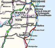
at its northern end. At its southern end it connects to the Pacific Highway
Pacific Highway (Australia)
The Pacific Highway is a major transport route along part of the east coast of Australia and is part of Australia's national route 1.It is 960 km long and links Sydney, the capital of New South Wales, to Brisbane, the capital of Queensland, along the coast, via Gosford, Newcastle, Taree, Port...
and at its northern end it connects to the D'Aguilar Highway
D'Aguilar Highway
The D'Aguilar Highway is a two-lane highway linking the Bruce Highway near Caboolture with Kingaroy in the state of Queensland, Australia. Major towns along the route include Woodford, Kilcoy, Yarraman, Nanango and Kingaroy...
. It traverses the Hunter Valley and New England
New England (Australia)
New England or New England North West is the name given to a generally undefined region about 60 kilometres inland, that includes the Northern Tablelands and the North West Slopes regions in the north of the state of New South Wales, Australia.-History:The region has been occupied by Indigenous...
regions of New South Wales
New South Wales
New South Wales is a state of :Australia, located in the east of the country. It is bordered by Queensland, Victoria and South Australia to the north, south and west respectively. To the east, the state is bordered by the Tasman Sea, which forms part of the Pacific Ocean. New South Wales...
and the Southern and Darling Downs of Queensland
Queensland
Queensland is a state of Australia, occupying the north-eastern section of the mainland continent. It is bordered by the Northern Territory, South Australia and New South Wales to the west, south-west and south respectively. To the east, Queensland is bordered by the Coral Sea and Pacific Ocean...
. It is 887 kilometres (551 mi) long.
Introduction
The New England Highway forms the major part of the 1047 kilometres (651 mi) SydneySydney
Sydney is the most populous city in Australia and the state capital of New South Wales. Sydney is located on Australia's south-east coast of the Tasman Sea. As of June 2010, the greater metropolitan area had an approximate population of 4.6 million people...
-Brisbane
Brisbane
Brisbane is the capital and most populous city in the Australian state of Queensland and the third most populous city in Australia. Brisbane's metropolitan area has a population of over 2 million, and the South East Queensland urban conurbation, centred around Brisbane, encompasses a population of...
national highway route. This route follows the Sydney-Newcastle Freeway
Sydney-Newcastle Freeway
The Sydney-Newcastle Freeway is a stretch of motorway linking Sydney to the Central Coast, Newcastle and Hunter regions of New South Wales. It is part of the AusLink road corridor between Sydney and Brisbane, carrying the route designation....
(part of national route 1), most of the New England and part of the Cunningham Highway
Cunningham Highway
The Cunningham Highway is a National Highway in Queensland, Australia. It is named after the explorer and botanist Allan Cunningham who followed a route close to where the modern day highway runs.-Route:...
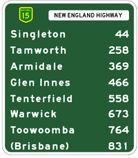
(the parts forming national route 15). The New England Highway north of Warwick
Warwick, Queensland
Warwick is a town in Queensland, Australia, lying south-west of Brisbane. It is the administrative centre of the Southern Downs Local Government Area. In 2006 the town of Warwick had a population of 12,562....
is not part of the national highway system.
The New England Highway is numbered as part of national route 15 between Hexham and Warwick and part of national route 42 from Warwick to Toowoomba
Toowoomba, Queensland
Toowoomba is a city in Southern Queensland, Australia. It is located west of Queensland's capital city, Brisbane. With an estimated district population of 128,600, Toowoomba is Australia's second largest inland city and its largest non-capital inland city...
, then Queensland state route 85 from Toowoomba to Hampton
Hampton, Queensland
Hampton is a town located in the Darling Downs region of Queensland, Australia. The town is located west of the state capital, Brisbane At the 2006 census, Hampton and the surrounding area had a population of 477...
, and Queensland state route 61 from Hampton to Yarraman
Yarraman, Queensland
Yarraman is a town in Queensland, Australia. The town is located northwest of the state capital, Brisbane on the junction of the New England and D'Aguilar highways.-History:...
. The highway terminates at Yarraman.
History
The New England Highway has its origins in the track which developed north from Newcastle to reach the prime wool growing areas of the New England region which Europeans settled following expeditions by New South Wales (NSW) Surveyor-General John Oxley in 1818 and botanist Allan Cunningham in 1827 and 1829. It became known as the Great Northern Road.Improvement was limited during the 19th century, initially due to the lack of traffic and funding, then the transfer of traffic from road to the parallel railway which opened in stages between 1857 and 1888 between Newcastle and Wallangarra
Wallangarra, Queensland
Wallangarra is a village on the border between Queensland and New South Wales in Australia. It is the third most southerly town in Queensland, 258 km south west of Brisbane. Wallangarra is on the Queensland side of the border and Jennings is on the New South Wales side...
.
When the NSW main road system was reorganised in August 1928, the Great Northern Road was gazetted as part of state highway 9, the Great Northern Highway. State highway 9 stretched from Milsons Point on the north shore of Sydney Harbour (at that time the Sydney Harbour Bridge was still under construction) via the under-construction road from Hornsby to Gosford
Gosford, New South Wales
Gosford is a city located on the Central Coast of New South Wales, Australia, approximately 76 km north of the Sydney central business district...
(completed 1930), then via Newcastle to Hexham then to Tenterfield
Tenterfield, New South Wales
Tenterfield is a town in New South Wales, Australia. It is located in the New England region at the intersection of the New England and Bruxner Highways. Tenterfield is a three-hour drive from Brisbane, 2.5 hours from Byron Bay, two hours from Armidale, New South Wales and 10 hours from Sydney....
. From Tenterfield it continued to the Queensland border near Mount Lindesay. The only major changes to this route have been a re-routing between Willow Tree
Willow Tree, New South Wales
Willow Tree is a village composed of about 169 people, located in New South Wales, Australia. It is situated in the Liverpool Plains, 14 kilometers south of Quirindi near the junction of the Kamilaroi and New England Highways. The town itself is small but the farms extend southwest out to the...
and Tamworth
Tamworth, New South Wales
Tamworth is a city in the New England region of New South Wales, Australia. Straddling the Peel River, Tamworth, which contains an estimated population of 47,595 people, is the major regional centre for southern New England and in the local government area of Tamworth Regional Council. The city...
to run via Wallabadah
Wallabadah, New South Wales
Wallabadah is a village in the New England region of New South Wales, Australia.The town is located 55 kilometres south of Tamworth on the New England Highway and is in the Liverpool Plains Shire. At the 2006 census, Wallabadah had a population of 746....
rather than via Quirindi
Quirindi, New South Wales
Quirindi is a small town on the North West Slopes region of New South Wales, Australia, in Liverpool Plains Shire Local Government Area ....
and Werris Creek
Werris Creek, New South Wales
Werris Creek is a small town in New South Wales, Australia, near Tamworth, in Liverpool Plains Shire. It is north of Quirindi and is at the junction of the Main North railway line to Armidale and Moree. At the 2006 census, Werris Creek had a population of 1,490.-History:The area is thought to...
, and a re-routing between Tenterfield and the NSW/Queensland border (see below).
In 1931, state highway 10, the North Coast Highway, which commenced at Hexham and extended to Tweed Heads
Tweed Heads, New South Wales
Tweed Heads is a town located on the Tweed River in north-eastern New South Wales, Australia in Tweed Shire. Tweed Heads is located next to the border with Queensland, adjacent to the "Twin Town" of Coolangatta, a suburb of the Gold Coast...
, was renamed the Pacific Highway and extended south to Milsons Point, so that state highway 9 began at Hexham, as it does today. In 1933 the Great Northern Highway was renamed the New England Highway.
In 1954 main road 374, running from Tenterfield to Wallangarra, was redesignated as part of state highway 9 and named as part of the New England Highway, and the section of the New England Highway from Tenterfield to Mount Lindesay was renumbered as state highway 24 and renamed the Mount Lindesay Highway
Mount Lindesay Highway
The Mount Lindesay Highway is a highway in Queensland which has been given the national route number 13. It runs from Brisbane, where it leaves Ipswich Road in the suburb of Moorooka , to the New South Wales border where it becomes the Summerland Way heading south to Kyogle.The highway used to...
. The rerouting of the New England Highway from Mount Lindesay to Wallangarra was due to the construction of a sealed road from Boonah through Cunninghams Gap to Warwick in the early 1950s. The sealed road encouraged much more traffic to travel from Brisbane to Tenterfield via Warwick than via Mount Lindesay and the unsealed route on to Tenterfield.
At the time of the rerouting of the New England Highway to Wallangarra and the naming of the Mount Lindesay Highway, arrangements were made by the NSW Department of Main Roads with the Queensland Main Roads Department to name the onward routes from Wallangarra and Mount Lindesay to Brisbane as the New England and Mount Lindesay Highways respectively. At this time they were allocated the national route numbers of 15 for the New England Highway Hexham-Brisbane and 13 for the Mount Lindesay Highway Brisbane-Tenterfield.
National highway function
The national highway network is a subset of the national routes for which the Commonwealth, rather than the state governments, has responsibility for maintenance and upgrading. National route 15 was designated as part of the national highwayNational Highway (Australia)
thumb|right|150px|The National Highway Shield in NSW, QLD, WA, NT & TAS.The National Highway is a system of roads connecting all the States and Territories of Australia, and is the major network of highways connecting Australia's largest and most important cities.The National Highway was...
network when it was established in 1974. This route covers the majority of the New England Highway, from Hexham to Warwick
Warwick, Queensland
Warwick is a town in Queensland, Australia, lying south-west of Brisbane. It is the administrative centre of the Southern Downs Local Government Area. In 2006 the town of Warwick had a population of 12,562....
.
Whilst, as a national highway, the New England Highway is part of the official major route between Sydney and Brisbane, most traffic uses the parallel Pacific Highway
Pacific Highway (Australia)
The Pacific Highway is a major transport route along part of the east coast of Australia and is part of Australia's national route 1.It is 960 km long and links Sydney, the capital of New South Wales, to Brisbane, the capital of Queensland, along the coast, via Gosford, Newcastle, Taree, Port...
, which follows the coast. It is therefore the only section of Australia’s national highway network where more traffic uses an alternative route.
Between Warwick and Tamworth the New England Highway, as well as being part of the national route between Sydney and Brisbane, is also an important interstate link between Queensland and Victoria
Victoria (Australia)
Victoria is the second most populous state in Australia. Geographically the smallest mainland state, Victoria is bordered by New South Wales, South Australia, and Tasmania on Boundary Islet to the north, west and south respectively....
, connecting to Melbourne via the Oxley Highway
Oxley Highway
The Oxley Highway is a rural highway in New South Wales, Australia. It starts at Nevertire where it joins the Mitchell Highway. It links Warren, Gilgandra, Coonabarabran, Gunnedah, Carroll, Tamworth, Bendemeer, Walcha, Yarrowitch, Ellenborough, Long Flat, Wauchope and ends at Port Macquarie on the...
to the Newell Highway
Newell Highway
The Newell Highway is the longest highway in New South Wales, Australia. It runs parallel to the eastern coast about 400 kilometres inland, and is the main inland direct road link from Victoria to Queensland, bypassing the more congested coastal areas of New South Wales...
(which becomes the Goulburn Valley Highway
Goulburn Valley Highway
The Goulburn Valley Highway / is a highway located in Victoria, Australia. The section north beyond the Hume Freeway is part of the Melbourne to Brisbane National Highway and is the main link between these two cities as well as a major link between Victoria and inland New South Wales...
where it crosses the Murray River
Murray River
The Murray River is Australia's longest river. At in length, the Murray rises in the Australian Alps, draining the western side of Australia's highest mountains and, for most of its length, meanders across Australia's inland plains, forming the border between New South Wales and Victoria as it...
).
Rapid growth of population and tourism along the NSW North Coast since the 1970s led to the Commonwealth and NSW governments jointly funding reconstruction of the Pacific Highway to freeway standard from the early 1990s onward. This work is ongoing - see separate entry on the Pacific Highway
Pacific Highway (Australia)
The Pacific Highway is a major transport route along part of the east coast of Australia and is part of Australia's national route 1.It is 960 km long and links Sydney, the capital of New South Wales, to Brisbane, the capital of Queensland, along the coast, via Gosford, Newcastle, Taree, Port...
. With progressive completion of these roadworks, the New England Highway has become the only national highway route with a lower intercapital traffic volume than an alternative route.
Route numbering
The numbering of the New England Highway is confused by the fact that route names and numbers in Australia are often not contiguous or consistent with each other. In addition, in Queensland there have been numerous name and number changes and extensions to the New England Highway since 1970.At the time of the rerouting of the New England Highway to Wallangarra and the naming of the Mount Lindesay Highway, arrangements were made by the NSW Department of Main Roads with the Queensland Main Roads Department to name the onward routes from Wallangarra and Mount Lindesay to Brisbane as the New England and Mount Lindesay Highways respectively. At this time they were allocated the national route numbers of 15 for the New England Highway Hexham-Tenterfield-Warwick-Brisbane and 13 for the Mount Lindesay Highway Brisbane-Tenterfield.
In the 1970s, the Queensland Main Roads Department rerouted the designation of the New England Highway north of Warwick to follow the former Lockyer-Darling Downs Highway (national route 17) so that it terminated in Toowoomba. The section of the highway between Brisbane and Warwick was renamed as part of the Cunningham Highway, which until that time had extended only westward from Warwick to Goondiwindi
Goondiwindi, Queensland
Goondiwindi is an Australian town of approximately 5,629 people. The town has an annual population growth of 1.4 percent. The name Goondiwindi derives from an Aboriginal word meaning "the resting place of the birds".-History:...
. The rerouted section of the New England Highway from Warwick to Toowoomba was renumbered from 17 to become part of national route 42, which until then also had only extended westward from Warwick to Goondiwindi. In the 1990s, the Main Roads Department extended the name New England Highway north from Toowoomba to the D'Aguilar Highway at Yarraman, but this section carries state route numbers, rather than a national route number. However it carries little traffic and performs a regional rather than a national function.
The NSW Roads and Traffic Authority is quietly implementing an unannounced state-based alpha-numeric route numbering system, abandoning the national route system used since the 1950s and the complementary state route numbering system used since the 1970s. No details of when this is to be completed have been announced. However, many alpha-numeric route signs are appearing on roads throughout the state, including the New England Highway. An example of this signage is on the bypass of Armidale
Armidale, New South Wales
Armidale is a city in the Northern Tablelands, New South Wales, Australia. Armidale Dumaresq Shire had a population of 19,485 people according to the 2006 census. It is the administrative centre for the Northern Tablelands region...
, where the route number 'A15' appears.
Track

Lake Liddell
Lake Liddell is located near Muswellbrook, in the Hunter Valley, New South Wales, Australia.Lake Liddell supplies cooling water for Liddell Power Station, and was expanded to accommodate its needs during construction of the power station.-See also:...
near Muswellbrook, the crossing of the Liverpool Range
Liverpool Range
The Liverpool Range is a mountain range and a lava-field province in New South Wales, Australia.The Liverpool Range starts from the volcanic plateau known as the Barrington Tops and runs for about 100 km westwards, forming the northern boundary of the Hunter Valley district...
at Nowlands Gap
Nowlands Gap
Nowlands Gap, also known as Nowlands Pass and Murrurundi Gap, is a pass over the Liverpool Range in central NSW Australia.William Nowland discovered Nowlands Gap north of Murrurundi in 1827. His route eventually became part of the Great North Road...
immediately north of Murrurundi
Murrurundi, New South Wales
Murrurundi is a rural town in Upper Hunter Shire, located in the Upper Hunter Valley of New South Wales. Murrurundi, which is 193 km by road from Newcastle and 309 km from Sydney, has a population of 1,330 people...
through South Tamworth, and the ascent of the Moonbi Range
Moonbi Range
The Moonbi Range is a chain of hills which forms a part of the Northern Tablelands, New South Wales, Australia.The range is located roughly 20 kilometres north east of the city of Tamworth situated at the bottom of the Wentworth Mounds, which is part of the Moonbi Range. These mounds form a spur of...
between Tamworth and Bendemeer
Bendemeer, New South Wales
Bendemeer is a village of 485 people on the Macdonald River in the New England region of New South Wales, Australia. It is situated at the junction of the New England and Oxley Highways.- History :...
.
As far as Muswellbrook the highway carries heavy industrial traffic associated with the extensive coal mining in the Hunter Valley. Duplication of the highway and bypasses of towns as far as Muswellbrook is propsoed by the Roads and Traffic Authority, but this propsal is unfunded with no timetable for its undertaking. Beyond Muswellbrook traffic volumes do not justify dual carriageways on most sections of the highway. The main substandard sections of the highway are generally in the upper Hunter Valley around Parkville, Wingen
Wingen, New South Wales
Wingen is a village in the Upper Hunter area of the Hunter Valley in New South Wales, Australia. Situated on the New England Highway, it lies about 15 minutes from the town of Scone. It is known for the local "Burning Mountain" tourist attraction, a burning underground coal seam...
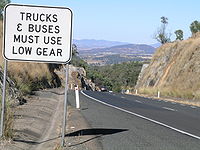
and Blandford. Once the highway climbs the Liverpool Range to the Northern Tablelands, most sections provide excellent driving.
In recent years the main upgrading activities in the Highway have been the deviation and duplication through Belford Forest, deviation and duplication over the Liverpool Range immediately north of Murrurundi, the Tamworth CBD bypass (an upgrading of an existing road), the Bendemeer bypass, the Armidale bypass, and deviations at Black Mountain and the Devils Pinch north of Armidale.
Long lengths of the New England Highway are subject to severe frost and snowfall, with the 350 km section from the Moonbi Ranges to Stanthorpe
Stanthorpe, Queensland
Stanthorpe is a town situated in south east Queensland, Australia. The town lies on the New England Highway near the New South Wales border 223 km from Brisbane via Warwick, 56 km north of Tenterfield and 811 m above sea level. The area surrounding the town is known as the Granite Belt...
located at high altitudes. The highest point on the Highway is where it crosses the Ben Lomond Range halfway between Armidale and Glen Innes.
Speed cameras have been installed on the New England Highway at:
- Lochinvar – between Robert Road and Station Lane
- Scone – between Eveleigh Circuit and Forbes Street
- Blandford – between Hayles Street and Mills Street
- Murrurundi – between Bernard Street and Adelaide Street
- Ben Lomond – between Ross Road and Ben Lomond Road
- Wallabadah – between Gaspard Road and Lowestoft Road
- Kootingal – between Gill Street and Yarrol Road
- Tilbuster – between Sunnyside Road and Tilbuster Ponds Bridge
- Llangothlin – between Ben Lomond Road and Everetts Road
- Tenterfield – between Duncan Street and George Street.


Highway improvements
The major projects since the Second World War in the ongoing upgrading of the New England Highway are:- Hexham-Tarro duplication (including Tarro railway overpass) (1964)
- Tarro-Beresfield bypass (dual carriageway) (Oct 1970)
- Tarro interchange (to connect to Anderson Drive) (May 1994)
- John Renshaw Drive interchange (Sep 1997)
- Weakleys Drive interchange (2008)
- Beresfield-East Maitland duplication (final stage Aug 1982)
- Maitland inner city bypass stage 1 (dual carriageway) (Feb 1986)
- Maitland inner city bypass stage 2 (dual carriageway) (Dec 1986)
- Maitland inner city bypass Stage 3 (dual carriageway) (Sep 1988)
- Widening to four lanes from the Long Bridge Telarah to Harvey Rd Rutherford (Aug 1982)
- Belford Forest deviation (dual carriageway) (Oct 1998)
- Deviation at Singleton including new bridge over Hunter River (May 1986)
- Chilcotts Creek deviation (Dec 1968)
- Liddell deviation (including 2 km dual carriageway) to allow creation of Lake Liddell (Jan 1967)
- Muswellbrook (north) railway overpass (May 1966)
- Duplication of 1893 bridge, Hunter River at Aberdeen for northbound traffic (each bridge since reconfigured to one lane only (Dec 1986)
- Reconstruction to four lanes along Kelly St Scone (1985)
- Halcombe Hill deviation (1 km north of Aberdeen) (Aug 2007)
- Bridge over Pages River at Blandford (previously a ford) (now used for southbound traffic) (Dec 1953)
- Duplicate bridge for northbound traffic, Pages River at Blandford (each bridge configured for one lane only) (2004)
- Liverpool Range deviation (dual carriageway), Murrurundi-Nowlands Gap (Oct 1994)
- Liverpool Range duplication (Nowlands Gap-Kankool) (Jan 1997)
- New bridge over Peel River in Tamworth (replaced 1881 bridge) (Apr 1965)
- Tamworth CBD bypass (upgrade of Calare Lane) (Nov 1993)
- Tintinhull realignment (Dec 1986)
- First Moonbi Hill duplication (1937 deviation retained as northbound carriageway) (Aug 1982)
- Rose Valley Creek deviation (33-36 km north of Tamworth) (2002)
- Bendemeer bypass (Dec 1985)
- Barleyfields deviation, Uralla (Feb 1980)
- Armidale bypass (Dec 1994)
- Duval Creek realignment (13-15 km north of Armidale) (Dec 2004)
- Realignment of highway at Tilbuster, near Sunnyside Rd (17-19 km north of Armidale) (Feb 2010)
- Devil's Pinch deviation stage 1 (Dec 1982)
- Devil's Pinch deviation stage 2 (May 1983)
- Devil's Pinch deviation stage 3 (22-27 km north of Armidale) (2002)
- Devil's Pinch (Black Mountain) deviation stage 4 (27-30 km north of Armidale) (April 2006)
- Guyra-Llangothlin deviation (Dec 1970)
- Marowan Creek bridge replacement, Glencoe (1995)
- Bolivia Hill deviation (Mar 1951)
- Stanthorpe bypass (1960s)
- Allora bypass (1960s)
- Harristown/Drayton deviation (1970s).
Current projects
- Freeway from Newcastle Freeway at Newcastle link road to beginning of Belford Forest deviation west of Branxton (40 km, $1.7 billion, scheduled for completion 2013) (see article Hunter Expressway)
Cities and towns
From its junction with the Pacific HighwayPacific Highway (Australia)
The Pacific Highway is a major transport route along part of the east coast of Australia and is part of Australia's national route 1.It is 960 km long and links Sydney, the capital of New South Wales, to Brisbane, the capital of Queensland, along the coast, via Gosford, Newcastle, Taree, Port...
at Hexham
Hexham, New South Wales
Hexham is a suburb of the city of Newcastle, about inland from Newcastle in New South Wales, Australia on the bank of the Hunter River.Settlement occurred at Hexham in the 1820s when the land was granted to Edward Sparke...
, 12 km inland from Newcastle
Newcastle, New South Wales
The Newcastle metropolitan area is the second most populated area in the Australian state of New South Wales and includes most of the Newcastle and Lake Macquarie Local Government Areas...
the New England Highway connects the following cities and towns:
- MaitlandMaitland, New South WalesMaitland is a city in the Lower Hunter Valley of New South Wales, Australia and the seat of Maitland City Council, situated on the Hunter River approximately by road north of Sydney and north-west of Newcastle...
- GretaGreta, New South WalesGreta is a small town in the Hunter Valley region of New South Wales, Australia in Cessnock City Council. It has a population of around 1000 people. It is largely a commuter town located midway between Cessnock, Singleton and Maitland...
- BranxtonBranxton, New South WalesBranxton is a town in the Hunter Valley region of New South Wales, Australia. Branxton is north of Sydney via the Sydney-Newcastle Freeway and New England Highway.Branxton is located mostly in Cessnock City Council, but part of it is in Singleton Shire...
- SingletonSingleton, New South Wales-Industry & Commerce:Major industries near Singleton include coal mining, energy generation, light industry, vineyards, horse breeding and cattle production. Dairying was once a mainstay in the area, but has declined....
- MuswellbrookMuswellbrook, New South WalesMuswellbrook, a corruption of 'Muscle Brook', is a town and Local Government Area in New South Wales, Australia. The original spelling and etymology of the town's name is a matter of some debate...
- AberdeenAberdeen, New South WalesAberdeen is a small town in the upper Hunter Valley region of New South Wales, Australia, in Upper Hunter Shire. It is located about 12 kilometres north of Muswellbrook on the New England Highway. Aberdeen is named after Aberdeen, Scotland. At the 2006 census, Aberdeen had a population of...
- SconeScone, New South WalesScone is a town in the Upper Hunter Shire in the Hunter Valley region of New South Wales, Australia. At the 2006 census, Scone had a population of 4,624 people. It is located on the New England Highway north of Muswellbrook about 270 kilometres north of Sydney, and is part of the Hunter and Upper...
- MurrurundiMurrurundi, New South WalesMurrurundi is a rural town in Upper Hunter Shire, located in the Upper Hunter Valley of New South Wales. Murrurundi, which is 193 km by road from Newcastle and 309 km from Sydney, has a population of 1,330 people...
- TamworthTamworth, New South WalesTamworth is a city in the New England region of New South Wales, Australia. Straddling the Peel River, Tamworth, which contains an estimated population of 47,595 people, is the major regional centre for southern New England and in the local government area of Tamworth Regional Council. The city...
- BendemeerBendemeer, New South WalesBendemeer is a village of 485 people on the Macdonald River in the New England region of New South Wales, Australia. It is situated at the junction of the New England and Oxley Highways.- History :...
- UrallaUralla, New South WalesUralla is a small town and on the Northern Tablelands, New South Wales, Australia. The town is located at the intersection of the New England Highway and Thunderbolts Way 465 kilometres north of Sydney and about 23 kilometres south west of the city of Armidale...
- ArmidaleArmidale, New South WalesArmidale is a city in the Northern Tablelands, New South Wales, Australia. Armidale Dumaresq Shire had a population of 19,485 people according to the 2006 census. It is the administrative centre for the Northern Tablelands region...
- GuyraGuyra, New South Wales-References:...
- Glen InnesGlen Innes, New South WalesGlen Innes is a parish and town on the Northern Tablelands, in the New England region of New South Wales, Australia. It is the centre of the Glen Innes Severn Shire Council. The town is located at the intersection of the New England Highway and the Gwydir Highway...
- TenterfieldTenterfield, New South WalesTenterfield is a town in New South Wales, Australia. It is located in the New England region at the intersection of the New England and Bruxner Highways. Tenterfield is a three-hour drive from Brisbane, 2.5 hours from Byron Bay, two hours from Armidale, New South Wales and 10 hours from Sydney....
In Queensland
- StanthorpeStanthorpe, QueenslandStanthorpe is a town situated in south east Queensland, Australia. The town lies on the New England Highway near the New South Wales border 223 km from Brisbane via Warwick, 56 km north of Tenterfield and 811 m above sea level. The area surrounding the town is known as the Granite Belt...
- WarwickWarwick, QueenslandWarwick is a town in Queensland, Australia, lying south-west of Brisbane. It is the administrative centre of the Southern Downs Local Government Area. In 2006 the town of Warwick had a population of 12,562....
- ToowoombaToowoomba, QueenslandToowoomba is a city in Southern Queensland, Australia. It is located west of Queensland's capital city, Brisbane. With an estimated district population of 128,600, Toowoomba is Australia's second largest inland city and its largest non-capital inland city...
Below is a short description of some of the towns on the New England Highway.
Maitland
Maitland was the original centre of European settlement in the Hunter Valley. In the early 19th century the focus was on food rather than coal, and the rich river flats around Maitland provided food for the young colony. It was not until the late 19th century that Newcastle eclipsed Maitland as the centre of the Hunter Valley. Nonetheless, Maitland retains a major role as an industrial centre, with a population of 55,000. In 1955 the city was severely damaged by flooding of the Hunter River.Singleton
Hunter Valley
The Hunter Region, more commonly known as the Hunter Valley, is a region of New South Wales, Australia, extending from approximately to north of Sydney with an approximate population of 645,395 people. Most of the population of the Hunter Region lives within of the coast, with 55% of the entire...
, with 13,000 residents. Although the Singleton district is dotted with vineyards and the town has grown in the past three decades, unlike many other country towns, this was due to employment in the coalmining industry and as a dormitory for Newcastle. A major army base is located nearby. The scenic but isolated Putty Road
Putty Road
Putty Road is a New South Wales country road linking Windsor, on the fringes of Sydney, to Singleton. It is designated as State Route 69 and is about 150 kilometres long. It is the northern end of State Route 69, connecting with Metroad 9 in Windsor and New England Highway in Singleton...
(state route 69) connects Singleton with Windsor and Sydney's northwestern suburbs.
Muswellbrook
The major centre of the Upper Hunter Valley, with a population of over 12,000. Nearby are two of NSW's two major power stations - Liddell (built 1968) and Bayswater (built 1981), which together account for over 40% of the electricity produced in NSW. The town has wide streets set in a sweeping pastoral landscape, and St Alban's Anglican church in the town was designed by famous English architect Giles Gilbert ScottGiles Gilbert Scott
Sir Giles Gilbert Scott, OM, FRIBA was an English architect known for his work on such buildings as Liverpool Cathedral and Battersea Power Station and designing the iconic red telephone box....
. Muswellbrook is the centre of major coal mining and wine producing areas, as well as thoroughbred horse breeding and agriculture.
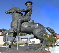
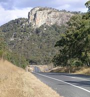
Scone
A town renowned for its thoroughbredThoroughbred
The Thoroughbred is a horse breed best known for its use in horse racing. Although the word thoroughbred is sometimes used to refer to any breed of purebred horse, it technically refers only to the Thoroughbred breed...
stud farms and regarded as the horse capital of Australia. Around Scone the Hunter Valley narrows and the sandstone escarpments enclosing the valley provide a stunning backdrop to the rolling green hills of the valley floor. North of Scone and adjacent to the Highway is Mount Wingen - the Burning Mountain
Burning Mountain
Burning Mountain, the common name for Mount Wingen, is a hill near Wingen, New South Wales, Australia, approximately north of Sydney just off the New England Highway. It takes its name from a smouldering coal seam running underground through the sandstone...
- where a light but constant plume of smoke issues from fissures in the ground, caused by lightning setting fire to coal seams close to the surface tens of thousands of years ago.
Tamworth
Set on the Peel River, Tamworth is the largest city in inland northern NSW with 35,000 inhabitants, and is the centre of a rich agricultural district. It is also a thriving industrial and commercial centre. Famous as the 'Country Music Capital' of Australia and its annual Tamworth Country Music FestivalTamworth Country Music Festival
The Tamworth Country Music Festival is an annual music festival held in Tamworth, New South Wales, Australia and is a celebration of Australian country music culture and heritage. The festival lasts for two weeks during late January and during this period the city of Tamworth comes alive, with...
. The Australian Equine and Livestock Events Centre
Australian Equine and Livestock Events Centre
The Australian Equine and Livestock Events Centre is a multi building and arena complex that was designed for equine usage. It has two indoor arenas, stabling, plus an education and training building, which is located on the New England Highway approximately five kilometres south of the Tamworth...
(AELEC) is located on the New England Highway on the southern outskirts of the city. In 1888 it became the first town in Australia to install electric street lighting.
Armidale
Located on the Northern Tablelands, Armidale's high altitude (over 1,000 m) gives it four pronounced seasons. It is also the hub of a thriving pastoral area famous for its high quality wool. The University of New EnglandUniversity of New England (Australia)
The University of New England is an Australian public university with approximately 18,000 higher education students. Its original and main campus is located in the city of Armidale in northern New South Wales....
, established in 1954, and is the main seat of learning in inland northern NSW and is a major employer. The student population makes up a significant proportion of the city's population of 22,000. Armidale features beautiful landscapes, parks and historic buildings. Also of note is the Hinton Art Gallery, which houses the Felton Bequest, a significant collection of work by Australian artists.
Glen Innes
A Celtic-flavoured town that owes much to the Scottish settlers who came to the district in the 1830s. A monument commemorates the part they played. 40 km east of Glen Innes along the Gwydir HighwayGwydir Highway
The Gwydir Highway is a 567 kilometre highway in northern New South Wales, Australia. It was named after the Gwydir River, which in turn was named for a locale in Wales....
are the world heritage areas of the Washpool rainforests.
Tenterfield
Known as the Birthplace of FederationFederation
A federation , also known as a federal state, is a type of sovereign state characterized by a union of partially self-governing states or regions united by a central government...
, being the town where NSW Premier Henry Parkes
Henry Parkes
Sir Henry Parkes, GCMG was an Australian statesman, the "Father of Federation." As the earliest advocate of a Federal Council of the colonies of Australia, a precursor to the Federation of Australia, he was the most prominent of the Australian Founding Fathers.Parkes was described during his...
delivered his Tenterfield Oration
Tenterfield Oration
The Tenterfield Oration was a speech given by Sir Henry Parkes at the Tenterfield School of Arts, New South Wales, Australia on 24 October 1889 asking for the Federation of the six Australian colonies, which were at the time self-governed but under the distant central authority of the British...
, making the case for federation of the colonies into the Commonwealth of Australia. The architecture of the 1886 railway station is of note for its ornateness and excellent state of preservation. It is also the hometown of the entertainer Peter Allen
Peter Allen
Peter Allen was an Australian songwriter and entertainer. His songs were made popular by many recording artists, including Elkie Brooks, Melissa Manchester and Olivia Newton-John, with one, Arthur's Theme, winning an Academy Award in 1981...
.
Wallangarra
The New England Highway crosses the State border into Queensland at WallangarraWallangarra, Queensland
Wallangarra is a village on the border between Queensland and New South Wales in Australia. It is the third most southerly town in Queensland, 258 km south west of Brisbane. Wallangarra is on the Queensland side of the border and Jennings is on the New South Wales side...
, famous for the railway break of gauge on the only rail link between Sydney and Brisbane from 1888 until the coastal standard gauge line was completed in 1930. Much of the railway yards needed for transhipping passengers and goods between the trains on the two different gauges remains.
Stanthorpe
Located just off the New England Highway, set at a high altitude in granite country and famous for its wineries and orchards. The outstanding Girraween National ParkGirraween National Park
Girraween National Park is an area of the Granite Belt in south-east Queensland, Australia reserved as a national park. Girraween is known for its spectacular flowers, dramatic landscapes and unique wildlife. Bushwalking and rock climbing are the most popular activities in the park.-Location:The...
to the south of Stanthorpe has excellent bushwalking and rockclimbing.
Warwick
Major centre of the Southern Downs with a population of 11,000, Warwick is set in rolling pastoral country on the banks of the Condamine RiverCondamine River
The Condamine River, part of the Murray-Darling Basin, drains the northern portion of the Darling Downs, an area of sub-coastal southern Queensland, Australia...
. Famous for its rose gardens and rodeo. From 15 km north of Warwick, national route 15 turns east to Cunninghams Gap and down into the Brisbane Valley via the Cunningham Highway
Cunningham Highway
The Cunningham Highway is a National Highway in Queensland, Australia. It is named after the explorer and botanist Allan Cunningham who followed a route close to where the modern day highway runs.-Route:...
to reach Ipswich
Ipswich, Queensland
Ipswich is a city in South-East Queensland, Australia. Situated along the Bremer River Valley approximately 40 kilometres away from the state's capital Brisbane. The suburb by the same name forms the city's Central Business District and administrative centre...
. From here Brisbane
Brisbane
Brisbane is the capital and most populous city in the Australian state of Queensland and the third most populous city in Australia. Brisbane's metropolitan area has a population of over 2 million, and the South East Queensland urban conurbation, centred around Brisbane, encompasses a population of...
is only another 30 km.
Toowoomba
With a population of 90,000, Toowoomba is one of Australia's major rural cities. Noted for its beautiful gardens as result of rich volcanic soils, it is home to the University of Southern QueenslandUniversity of Southern Queensland
The University of Southern Queensland is based in Toowoomba, Queensland, Australia. The institution was established in 1967 as the Queensland Institute of Technology...
and is the commercial and administrative centre of the Darling Downs region.
See also
- Highways in AustraliaHighways in AustraliaThis is a list of highways in Australia, listed alphabetically along with each highway's route number and location. Note that some highways service more than one state or territory.-Route numbering systems:...
- WikiTravel - New England Highway
- List of highways in New South Wales
- List of highways in Queensland
- Moonbi RangeMoonbi RangeThe Moonbi Range is a chain of hills which forms a part of the Northern Tablelands, New South Wales, Australia.The range is located roughly 20 kilometres north east of the city of Tamworth situated at the bottom of the Wentworth Mounds, which is part of the Moonbi Range. These mounds form a spur of...
- Hunter Expressway