
Mitchell, Queensland
Encyclopedia

Maranoa, Queensland
The Maranoa is the name given to an area of southern Queensland. Some refer to the Maranoa as the Western Downs. The Maranoa is an eastern part of the larger, mostly arid South West region of Queensland...
region of Queensland
Queensland
Queensland is a state of Australia, occupying the north-eastern section of the mainland continent. It is bordered by the Northern Territory, South Australia and New South Wales to the west, south-west and south respectively. To the east, Queensland is bordered by the Coral Sea and Pacific Ocean...
, Australia
Australia
Australia , officially the Commonwealth of Australia, is a country in the Southern Hemisphere comprising the mainland of the Australian continent, the island of Tasmania, and numerous smaller islands in the Indian and Pacific Oceans. It is the world's sixth-largest country by total area...
. It is on the Warrego Highway
Warrego Highway
The Warrego Highway is located in southern Queensland, Australia. It connects coastal centres to the south western areas of the state, and is approximately 750 km in length. It takes its name from the Warrego River, which is the endpoint of the highway...
, 587 kilometres west of Brisbane
Brisbane
Brisbane is the capital and most populous city in the Australian state of Queensland and the third most populous city in Australia. Brisbane's metropolitan area has a population of over 2 million, and the South East Queensland urban conurbation, centred around Brisbane, encompasses a population of...
and 176 kilometres east of Charleville
Charleville, Queensland
Charleville is a town in south western Queensland, Australia, 758 kilometres by road west of Brisbane . It is the largest town and administrative centre of the Murweh Shire, which covers an area of 43,905 square kilometres...
. At the 2006 census
Census in Australia
The Australian census is administered once every five years by the Australian Bureau of Statistics. The most recent census was conducted on 9 August 2011; the next will be conducted in 2016. Prior to the introduction of regular censuses in 1961, they had also been run in 1901, 1911, 1921, 1933,...
, Mitchell had a population of 944.
The Warrego Highway
Warrego Highway
The Warrego Highway is located in southern Queensland, Australia. It connects coastal centres to the south western areas of the state, and is approximately 750 km in length. It takes its name from the Warrego River, which is the endpoint of the highway...
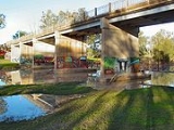
passes through town to form the main street, Cambridge Street. The Maranoa River
Maranoa River
The Maranoa River is a large river situated in south west Queensland. The Maranoa passes through Mitchell and flows south towards St George. It is a tributary of the Balonne River which eventually flows into the Darling River , so it contributes to the Murray-Darling Basin.The river rises on the...
flows around the northern and eastern sides of the town before flowing into the Balonne River
Balonne River
The Balonne River, part of the Murray-Darling Basin system, is a short but important part of the inland river group of south-eastern Queensland. This river is a continuation of the Condamine River. After flowing through Surat the river flows south south-westerly down through the E.J...
.
The town services the local area, a cattle and sheep farming district.
History
Before the arrival of EuropeEurope
Europe is, by convention, one of the world's seven continents. Comprising the westernmost peninsula of Eurasia, Europe is generally 'divided' from Asia to its east by the watershed divides of the Ural and Caucasus Mountains, the Ural River, the Caspian and Black Seas, and the waterways connecting...
ans, the Maranoa region was occupied by the Mandandanji Aboriginal people. Based on archeological excavations in the Mount Moffatt area, it has been deduceed that the Aboriginals had lived there for around 19,500 years.
The town is named after Sir Thomas Mitchell explorer and Surveyor General of New South Wales
New South Wales
New South Wales is a state of :Australia, located in the east of the country. It is bordered by Queensland, Victoria and South Australia to the north, south and west respectively. To the east, the state is bordered by the Tasman Sea, which forms part of the Pacific Ocean. New South Wales...
, who explored the area in 1846. In 1854, Edmund Morey established the property of Mitchell Downs. When the original homestead was largely destroyed by a flood in 1864, Thomas Close acquired the building's ruins established the Maranoa Hotel. A post office operated on Mitchell downs from 1865 and in 1878 the community was officially named Mitchell.
The 15th Prime Minister of Australia
Prime Minister of Australia
The Prime Minister of the Commonwealth of Australia is the highest minister of the Crown, leader of the Cabinet and Head of Her Majesty's Australian Government, holding office on commission from the Governor-General of Australia. The office of Prime Minister is, in practice, the most powerful...
Francis Forde
Frank Forde
Francis Michael Forde PC was an Australian politician and the 15th Prime Minister of Australia. He was the shortest serving Prime Minister in Australia's history, being in office for only eight days.-Early life:...
was born in Mitchell. He is Australia's shortest serving Prime Minister, with a term lasting just eight days. He was also Australia's longest living Prime Minister, until surpassed by Gough Whitlam on 21 January 2009.
In 1902, after a short stand-off, bushrangers Patrick and James Kenniff were captured south of Mitchell at a location now known as arrest creek. Patrick was hanged in 1903 for the murder of Constable George Doyle and Albert Dahlke and James was released after 12 years imprisonment and died peacefully in 1940.
Mitchell was once the administrative centre of the Shire of Booringa
Shire of Booringa
Shire of Booringa was a Local Government Area in the Maranoa region of Queensland, Australia. The largest town and home of the shire administration was Mitchell. The shire is now part of the Maranoa Region....
local government area. The town is now part of the Maranoa Region.
Great Artesian Spa
The Great Artesian Spa was opened in 1998 and is situated in the town’s aquatic centre.There are two pools of artesian water, one heated and the other designed for those who prefer a cooler experience. Both spa pools have been designed with disabled access in mind and facilities include a chairlift to allow easy access for physically disabled people.
The water used in the spa pools is renewed regularly and comes from the Great Artesian Basin
Great Artesian Basin
The Great Artesian Basin provides the only reliable source of freshwater through much of inland Australia. The basin is the largest and deepest artesian basin in the world, stretching over a total of , with temperatures measured ranging from 30°C to 100°C...
, one of the largest artesian basins in the world, which underlying approximately one-fifth of Australia. It covers a total area of more than 1,711,000 square kilometres, and has been relied upon for the town water supply since 1927.
See also
- AugathellaAugathella, QueenslandAugathella is a town in western Queensland, Australia, and is part of the Murweh Shire. Augathella lies on the Matilda Highway, is north of the town of Charleville, and west of Brisbane . The town lies on the banks of the Warrego River...
- MorvenMorven, QueenslandMorven is a town in western Queensland, Australia. The town is located on the Warrego Highway, east of Charleville and west of Brisbane. At the 2006 census, Morven had a population of 276....
- RomaRoma, QueenslandRoma is a town in the western Darling Downs area of Queensland, Australia, by rail WNW of Brisbane. It is situated at the junction of the Warrego and Carnarvon highways...
- Neil Turner WeirNeil Turner WeirNeil Turner Weir is a small weir located on the northern side of the town of Mitchell, in Queensland, Australia. The weir holds back the waters of the Maranoa River. A campsite exists, with free toilet facilities...
External links
- Booringa Shire Council - Official site
- Roma Region - Official Site
- University of Queensland: Queensland Places: Mitchell
- Maranoa Online - Mitchell page
- Maranoa Online A portal servicing the Maranoa - a region encompassing Mitchell
- visitmitchell.com.au - a tourism information site.