

Gore Highway
Encyclopedia
Gore Highway is a highway in Queensland
running from Goondiwindi
to Toowoomba
. Together with Goulburn Valley Highway
and Newell Highway
, it is a part of the National Highway
's Melbourne
-Brisbane
link. It is signed as .
.
 It passes through the Queensland's Darling Downs
region. Typical scenery are cattle grazing fields, orchards and grain growing fields. Its elevation to National Highway was only in February 1993 replacing Cunningham Highway
for the Goondiwindi - Brisbane section, rerouting interstate traffic through Toowoomba and the Warrego Highway
instead as it presents a less steeper gradient compared to the old routing, (via Warwick
and Cunninghams Gap) making the journey, especially for trucks, faster. It was initially designated State Route 85 until February 1993 when National Highway 85 was proclaimed, splitting State Route 85 into two. In 2005 it was given the National Highway A39 designation.
Queensland
Queensland is a state of Australia, occupying the north-eastern section of the mainland continent. It is bordered by the Northern Territory, South Australia and New South Wales to the west, south-west and south respectively. To the east, Queensland is bordered by the Coral Sea and Pacific Ocean...
running from Goondiwindi
Goondiwindi, Queensland
Goondiwindi is an Australian town of approximately 5,629 people. The town has an annual population growth of 1.4 percent. The name Goondiwindi derives from an Aboriginal word meaning "the resting place of the birds".-History:...
to Toowoomba
Toowoomba, Queensland
Toowoomba is a city in Southern Queensland, Australia. It is located west of Queensland's capital city, Brisbane. With an estimated district population of 128,600, Toowoomba is Australia's second largest inland city and its largest non-capital inland city...
. Together with Goulburn Valley Highway
Goulburn Valley Highway
The Goulburn Valley Highway / is a highway located in Victoria, Australia. The section north beyond the Hume Freeway is part of the Melbourne to Brisbane National Highway and is the main link between these two cities as well as a major link between Victoria and inland New South Wales...
and Newell Highway
Newell Highway
The Newell Highway is the longest highway in New South Wales, Australia. It runs parallel to the eastern coast about 400 kilometres inland, and is the main inland direct road link from Victoria to Queensland, bypassing the more congested coastal areas of New South Wales...
, it is a part of the National Highway
National Highway (Australia)
thumb|right|150px|The National Highway Shield in NSW, QLD, WA, NT & TAS.The National Highway is a system of roads connecting all the States and Territories of Australia, and is the major network of highways connecting Australia's largest and most important cities.The National Highway was...
's Melbourne
Melbourne
Melbourne is the capital and most populous city in the state of Victoria, and the second most populous city in Australia. The Melbourne City Centre is the hub of the greater metropolitan area and the Census statistical division—of which "Melbourne" is the common name. As of June 2009, the greater...
-Brisbane
Brisbane
Brisbane is the capital and most populous city in the Australian state of Queensland and the third most populous city in Australia. Brisbane's metropolitan area has a population of over 2 million, and the South East Queensland urban conurbation, centred around Brisbane, encompasses a population of...
link. It is signed as
.Darling Downs, Queensland
The Darling Downs is a farming region on the western slopes of the Great Dividing Range in southern Queensland, Australia. The Downs are to the west of South East Queensland and are one of eleven major regions of Queensland....
region. Typical scenery are cattle grazing fields, orchards and grain growing fields. Its elevation to National Highway was only in February 1993 replacing Cunningham Highway
Cunningham Highway
The Cunningham Highway is a National Highway in Queensland, Australia. It is named after the explorer and botanist Allan Cunningham who followed a route close to where the modern day highway runs.-Route:...
for the Goondiwindi - Brisbane section, rerouting interstate traffic through Toowoomba and the Warrego Highway
Warrego Highway
The Warrego Highway is located in southern Queensland, Australia. It connects coastal centres to the south western areas of the state, and is approximately 750 km in length. It takes its name from the Warrego River, which is the endpoint of the highway...
instead as it presents a less steeper gradient compared to the old routing, (via Warwick
Warwick, Queensland
Warwick is a town in Queensland, Australia, lying south-west of Brisbane. It is the administrative centre of the Southern Downs Local Government Area. In 2006 the town of Warwick had a population of 12,562....
and Cunninghams Gap) making the journey, especially for trucks, faster. It was initially designated State Route 85 until February 1993 when National Highway 85 was proclaimed, splitting State Route 85 into two. In 2005 it was given the National Highway A39 designation.
Speed Zones
- Drayton (Toowoomba) - Westbrook 90 km/h
- Westbrook - Millmerran (25 km South West) 100 km/h
- Millmerran - Goondiwindi 110 km/h
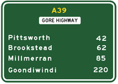
Towns
- GoondiwindiGoondiwindi, QueenslandGoondiwindi is an Australian town of approximately 5,629 people. The town has an annual population growth of 1.4 percent. The name Goondiwindi derives from an Aboriginal word meaning "the resting place of the birds".-History:...
- MillmerranMillmerran, QueenslandMillmerran is a town in the Darling Downs region of Queensland, Australia. The town is situated on the Gore Highway, 208 kilometres west of the state capital, Brisbane...
- PittsworthPittsworth, QueenslandPittsworth is a town located in the Darling Downs region of southern Queensland, Australia.-Location:Located 169 km south-west of Brisbane via the Warrego Highway, 41 km south-west of Toowoomba and 518 m above sea-level, Pittsworth presents itself to the world as a town with lots of interesting...
- ToowoombaToowoomba, QueenslandToowoomba is a city in Southern Queensland, Australia. It is located west of Queensland's capital city, Brisbane. With an estimated district population of 128,600, Toowoomba is Australia's second largest inland city and its largest non-capital inland city...
See also
- Highways in AustraliaHighways in AustraliaThis is a list of highways in Australia, listed alphabetically along with each highway's route number and location. Note that some highways service more than one state or territory.-Route numbering systems:...
- List of highways in Queensland