
South Burnett
Encyclopedia
The South Burnett
is a peanut growing and wine-producing region on the Great Dividing Range
, north of the Darling Downs, in Queensland
.
, Kilkivan
, Goomeri
, Proston
, Blackbutt
, Benarkin, Nanango
, Cloyna and Tingoora
.
leads south east, while the Bunya Highway
enters the region from the south west. The Wide Bay Highway
connects to Gympie
and the Bruce Highway
towards the coast and the Burnett Highway
continues north of the region.
The Brisbane Valley railway line reached Blackbutt in 1905. The line was closed in the 1980s.
-growing district centered around Kingaroy.
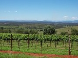
The South Burnett Wine Region is another attraction, with Verdelho grown successfully, due to the hot climate and rich soils. With only ten wineries, it is a very new wine region with a lot of energy.
12 km from Murgon is the Bjelke-Petersen Dam
. Other dams in the region include Gordonbrook Dam
and Boondooma Dam
. Tarong Power Station and the Tarong National Park
are both in the south of the Burnett.
The Bunya Mountains
, protected within the Bunya Mountains National Park
, which contains the largest natural bunya pine
forest in the world, are a popular natural attraction in the south of the region.
At Kinbombi Falls there are picnic and camping facilities next to a large waterfall, gorge and rocky creek. Rock-wallabies can be seen on local cliffs, particularly around twilight hours.
Garnet
gem fields are found just west of Proston.
Burnett River
The Burnett River is a river in central Queensland, Australia that empties into the Pacific Ocean near the city of Bundaberg. The Burnett River region is largely given over to growing sugar cane....
is a peanut growing and wine-producing region on the Great Dividing Range
Great Dividing Range
The Great Dividing Range, or the Eastern Highlands, is Australia's most substantial mountain range and the third longest in the world. The range stretches more than 3,500 km from Dauan Island off the northeastern tip of Queensland, running the entire length of the eastern coastline through...
, north of the Darling Downs, in Queensland
Queensland
Queensland is a state of Australia, occupying the north-eastern section of the mainland continent. It is bordered by the Northern Territory, South Australia and New South Wales to the west, south-west and south respectively. To the east, Queensland is bordered by the Coral Sea and Pacific Ocean...
.
Towns
Towns located within this region include Kingaroy, Murgon, WondaiWondai, Queensland
Wondai is a town in the South Burnett region of Queensland, Australia. The town is located to the south of the Bunya Highway, north west of the state capital, Brisbane. At the 2006 census, Wondai had a population of 1,402...
, Kilkivan
Kilkivan, Queensland
Kilkivan is a town in the South Burnett region of Queensland, Australia. The town is located on the Wide Bay Highway, north of the state capital, Brisbane and west of Gympie. At the 2006 census, Kilkivan had a population of 339....
, Goomeri
Goomeri, Queensland
Goomeri is a town in the South Burnett region of Queensland, Australia. The town is located on the intersection of the Burnett, Bunya and Wide Bay Highways, from the state capital, Brisbane. Part of the Gympie Local government area, at the 2006 census, Goomeri had a population of 488...
, Proston
Proston, Queensland
Proston is a small town in the south east of the Australian state of Queensland. The town is located 280 kilometres north west of the state capital, Brisbane and 50 km northwest of the South Burnett regions commercial centre, Kingaroy...
, Blackbutt
Blackbutt, Queensland
Blackbutt is a town in the South Burnett region of Queensland, Australia. The town is located on the D'Aguilar Highway, in the South Burnett Local Government Area, 166 kilometres north west of the state capital, Brisbane. At the 2006 census, Blackbutt had a population of 572.European settlement...
, Benarkin, Nanango
Nanango, Queensland
Nanango is a town in the South Burnett region of Queensland, Australia. It is the fourth oldest town in Queensland. At the 2006 census, Nanango had a population of 3,083. It is situated north-west of the state capital, Brisbane...
, Cloyna and Tingoora
Tingoora, Queensland
Tingoora is a town in the South Burnett region of Queensland, Australia. The town is in the South Burnett Region LGA and on the Bunya Highway, north west of the state capital, Brisbane. At the 2006 census, Tingoora had a population of 175....
.
Transport
The D'Aguilar HighwayD'Aguilar Highway
The D'Aguilar Highway is a two-lane highway linking the Bruce Highway near Caboolture with Kingaroy in the state of Queensland, Australia. Major towns along the route include Woodford, Kilcoy, Yarraman, Nanango and Kingaroy...
leads south east, while the Bunya Highway
Bunya Highway
The Bunya Highway is a 173 kilometre state highway of Queensland, Australia. It is a relatively short road, running approximately 170 kilometres in a south-westerly direction from Goomeri to Dalby. The highway connects the Warrego and Burnett Highways....
enters the region from the south west. The Wide Bay Highway
Wide Bay Highway
The Wide Bay Highway is a state highway of Queensland, Australia. It is a rather short road, running approximately 45 kilometres in an east-west direction linking Goomeri to Gympie...
connects to Gympie
Gympie
Gympie may refer to:* Gympie, a city in Queensland, Australia** Gympie Airport** Electoral district of Gympie** Gympie Region, its local government authority* Gympie Gympie , a stinging plant...
and the Bruce Highway
Bruce Highway
The Bruce Highway is a major highway in Queensland, Australia. Commencing in the state capital, Brisbane, it passes through areas close to the eastern coast to Cairns in Far North Queensland. The route is a part of the Australian National Highway and also part of Highway 1...
towards the coast and the Burnett Highway
Burnett Highway
The Burnett Highway is an inland rural highway located in Queensland, Australia. The highway runs generally north - south, from its junction with the Bruce Highway, just south of Rockhampton, to Nanango. Length is approximately 550 kilometres...
continues north of the region.
The Brisbane Valley railway line reached Blackbutt in 1905. The line was closed in the 1980s.
Attractions
One of the best known attractions in the area is the peanutPeanut
The peanut, or groundnut , is a species in the legume or "bean" family , so it is not a nut. The peanut was probably first cultivated in the valleys of Peru. It is an annual herbaceous plant growing tall...
-growing district centered around Kingaroy.
The South Burnett Wine Region is another attraction, with Verdelho grown successfully, due to the hot climate and rich soils. With only ten wineries, it is a very new wine region with a lot of energy.
12 km from Murgon is the Bjelke-Petersen Dam
Bjelke-Petersen Dam
Construction of Bjelke-Petersen Dam near Cherbourg in Queensland, commenced in 1984 and finished in 1988. It created the lake that was named Lake Barambah after the original property in the region. The dam supplies water to the South Burnett region, mostly for irrigation purposes.The dam wall is ...
. Other dams in the region include Gordonbrook Dam
Gordonbrook Dam
Gordonbrook Dam is the sole source of water supply for Kingaroy, Queensland; it was built in 1941 to provide water for the Royal Australian Air Force Training Base during WWII. In 1987 due to increased demand the dam wall was raised and the inundated area is now 229 hectares.-References:...
and Boondooma Dam
Boondooma Dam
Boondooma Dam is a dam on the Boyne River in the South Burnett region of Queensland, Australia. In 1983, the dam was constructed across the Boyne River below its confluence with the Stuart River....
. Tarong Power Station and the Tarong National Park
Tarong National Park
Tarong is a national park in Queensland, Australia, 137 km northwest of Brisbane....
are both in the south of the Burnett.
The Bunya Mountains
Bunya Mountains
The Bunya Mountains are a distinctive set of peaks forming an isolated section of the Great Dividing Range in southern Queensland. The mountain range forms the northern edge of the Darling Downs near Bell and Dalby. The mountains are south of Kingaroy and just to the south west of Nanango...
, protected within the Bunya Mountains National Park
Bunya Mountains National Park
Bunya Mountains is a national park in Queensland, Australia. The park includes much of the mountain range called the Bunya Mountains. The mountains are covered by the most westerly forests in southern Queensland and the largest area of bunya pines remaining in the world...
, which contains the largest natural bunya pine
Araucaria bidwillii
Araucaria bidwillii, the Bunya Pine, is a large evergreen coniferous tree in the genus Araucaria, family Araucariaceae. It is native to south-east Queensland with two small disjunct populations in northern Queensland's World Heritage listed Wet Tropics, and many fine old specimens planted in New...
forest in the world, are a popular natural attraction in the south of the region.
At Kinbombi Falls there are picnic and camping facilities next to a large waterfall, gorge and rocky creek. Rock-wallabies can be seen on local cliffs, particularly around twilight hours.
Garnet
Garnet
The garnet group includes a group of minerals that have been used since the Bronze Age as gemstones and abrasives. The name "garnet" may come from either the Middle English word gernet meaning 'dark red', or the Latin granatus , possibly a reference to the Punica granatum , a plant with red seeds...
gem fields are found just west of Proston.
External links
- South Burnett CTC - Large community-based organisation located in the South Burnett
- South Burnett Online - Popular South Burnett focused community portal