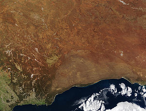
The
Great Australian Bight is a large
bightIn geography, bight has two meanings. A bight can be simply a bend or curve in any geographical feature—usually a bend or curve in the line between land and water....
, or open bay, off the central and western portions of the southern coastline of mainland
AustraliaAustralia , officially the Commonwealth of Australia, is a country in the Southern Hemisphere comprising the mainland of the Australian continent, the island of Tasmania, and numerous smaller islands in the Indian and Pacific Oceans. It is the world's sixth-largest country by total area...
.
Extent
The
International Hydrographic OrganizationThe International Hydrographic Organization is the inter-governmental organisation representing the hydrographic community. It enjoys observer status at the UN and is the recognised competent authority on hydrographic surveying and nautical charting...
defines the Great Australian Bight as part of the southeastern
Indian OceanThe Indian Ocean is the third largest of the world's oceanic divisions, covering approximately 20% of the water on the Earth's surface. It is bounded on the north by the Indian Subcontinent and Arabian Peninsula ; on the west by eastern Africa; on the east by Indochina, the Sunda Islands, and...
, with the following limits:
On the North. The South coast of AustraliaAustralia , officially the Commonwealth of Australia, is a country in the Southern Hemisphere comprising the mainland of the Australian continent, the island of Tasmania, and numerous smaller islands in the Indian and Pacific Oceans. It is the world's sixth-largest country by total area...
.
On the South.
A line joining West Cape HoweWest Cape Howe National Park is a national park in Western Australia , southeast of Perth. The park is found between Albany and Denmark within the City of Albany and in the Great Southern region....
(35°08′S 117°37′E) Australia to South West Cape, TasmaniaTasmania is an Australian island and state. It is south of the continent, separated by Bass Strait. The state includes the island of Tasmania—the 26th largest island in the world—and the surrounding islands. The state has a population of 507,626 , of whom almost half reside in the greater Hobart...
.
On the East. A line from Cape OtwayCape Otway is a cape in south Victoria, Australia on the Great Ocean Road; much of the area is enclosed in the Otway National Park.-History:...
, Australia, to King Island and thence to Cape GrimCape Grim is the northwestern point of Tasmania, Australia.It is the location of the Cape Grim Baseline Air Pollution Station which is operated by the Australian Bureau of Meteorology in a joint programme with the CSIRO....
, the Northwest extreme of Tasmania.
Another definition is that the Bight's boundaries are from Cape Pasley,
Western AustraliaWestern Australia is a state of Australia, occupying the entire western third of the Australian continent. It is bounded by the Indian Ocean to the north and west, the Great Australian Bight and Indian Ocean to the south, the Northern Territory to the north-east and South Australia to the south-east...
, to Cape Carnot,
South AustraliaSouth Australia is a state of Australia in the southern central part of the country. It covers some of the most arid parts of the continent; with a total land area of , it is the fourth largest of Australia's six states and two territories.South Australia shares borders with all of the mainland...
- a distance of 1,160 km or 720 miles.
The much more generally accepted name in Australia for the adjoining waterbody is the Southern Ocean rather than the
Indian OceanThe Indian Ocean is the third largest of the world's oceanic divisions, covering approximately 20% of the water on the Earth's surface. It is bounded on the north by the Indian Subcontinent and Arabian Peninsula ; on the west by eastern Africa; on the east by Indochina, the Sunda Islands, and...
. Much of the Bight lies due south of the expansive
Nullarbor PlainThe Nullarbor Plain is part of the area of flat, almost treeless, arid or semi-arid country of southern Australia, located on the Great Australian Bight coast with the Great Victoria Desert to its north. It is the world's largest single piece of limestone, and occupies an area of about...
, which straddles the two Australian states of
South AustraliaSouth Australia is a state of Australia in the southern central part of the country. It covers some of the most arid parts of the continent; with a total land area of , it is the fourth largest of Australia's six states and two territories.South Australia shares borders with all of the mainland...
and
Western AustraliaWestern Australia is a state of Australia, occupying the entire western third of the Australian continent. It is bounded by the Indian Ocean to the north and west, the Great Australian Bight and Indian Ocean to the south, the Northern Territory to the north-east and South Australia to the south-east...
.
Exploration
The Great Australian Bight was first encountered by European explorers in 1627, when a Dutch navigator,
François ThijssenFrançois Thijssen or Frans Thijsz was a Dutch explorer who explored the southern coast of Australia.He was the captain of the ship t Gulden Zeepaerdt when sailing from Cape of Good Hope to Batavia...
, sailed along its western margins. The coast was later first accurately charted by the English explorer Captain
Matthew FlindersCaptain Matthew Flinders RN was one of the most successful navigators and cartographers of his age. In a career that spanned just over twenty years, he sailed with Captain William Bligh, circumnavigated Australia and encouraged the use of that name for the continent, which had previously been...
in 1802, during his
circumnavigationCircumnavigation – literally, "navigation of a circumference" – refers to travelling all the way around an island, a continent, or the entire planet Earth.- Global circumnavigation :...
of the Australian
continentA continent is one of several very large landmasses on Earth. They are generally identified by convention rather than any strict criteria, with seven regions commonly regarded as continents—they are : Asia, Africa, North America, South America, Antarctica, Europe, and Australia.Plate tectonics is...
. A later land-based survey was accomplished by
Edward John EyreEdward John Eyre was an English land explorer of the Australian continent, colonial administrator, and a controversial Governor of Jamaica....
.
Natural history
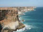
The coast line of the Great Australian Bight is characterised by cliff faces (up to 60 m high), surfing beaches and rock platforms, ideal for whale-watching. The waters of the Great Australian Bight, despite being relatively shallow, are not fertile. While most
continental shelvesThe continental shelf is the extended perimeter of each continent and associated coastal plain. Much of the shelf was exposed during glacial periods, but is now submerged under relatively shallow seas and gulfs, and was similarly submerged during other interglacial periods. The continental margin,...
are rich in sea life and make popular
fishingFishing is the activity of trying to catch wild fish. Fish are normally caught in the wild. Techniques for catching fish include hand gathering, spearing, netting, angling and trapping....
areas, the barren
desertA desert is a landscape or region that receives an extremely low amount of precipitation, less than enough to support growth of most plants. Most deserts have an average annual precipitation of less than...
s north of the bight have very little rainfall, and what there is mostly flows inland, to dissipate underground or in salt lakes. In consequence, the Great Australian Bight receives very little of the runoff that fertilises most continental shelves and is essentially a marine desert. It is probably best noted for the large number of
sharkSharks are a type of fish with a full cartilaginous skeleton and a highly streamlined body. The earliest known sharks date from more than 420 million years ago....
s that frequent its coastal waters, as well as the increasing numbers of
Southern Right WhalesRight whales are three species of large baleen whales consisting of two genera in the family Balaenidae of order Cetacea. Their bodies are very dark gray or black and rotund....
that migrate within the region.
One location on the bight that is specifically oriented towards the understanding of the natural history on its coastline is the
Eyre Bird ObservatoryEyre Bird Observatory is an educational, scientific and recreational facility in the Nuytsland Nature Reserve, Western Australia.Cocklebiddy is the nearest locality on the Eyre Highway 49 km to the north....
.
Current conditions
Economically, the Bight has been exploited over many years as part of the fishing, whaling and shellfish industries.
Bluefin tunaThe southern bluefin tuna, Thunnus maccoyii, is a tuna of the family Scombridae found in open southern hemisphere waters of all the world's oceans mainly between 30°S and 50°S, to nearly 60°S...
have been a favoured target of fishing in the Bight.
The settlements existing along the coastline of the Bight, such as
CedunaCeduna is a small town in the West Coast region of South Australia. It is situated in the northwest corner of Eyre Peninsula, facing the islands of the Nuyts Archipelago. It lies west of the junction of the Flinders and Eyre Highways around 786 km northwest of the capital Adelaide. The port...
and
EuclaEucla is the easternmost locality in Western Australia, located in the Goldfields-Esperance region of Western Australia along the Eyre Highway, approximately west of the South Australian border...
have facilities to access the bight. Some other locations on the
Eyre HighwayThe Eyre Highway is a highway linking Western Australia and South Australia via the Nullarbor Plain. Signed as National Highway 1/A1, it forms part of Highway 1 and the Australian National Highway network linking Perth and Adelaide. It was named after explorer Edward John Eyre, who was the first to...
or located on the
NullarborThe Nullarbor Plain is part of the area of flat, almost treeless, arid or semi-arid country of southern Australia, located on the Great Australian Bight coast with the Great Victoria Desert to its north. It is the world's largest single piece of limestone, and occupies an area of about...
do not have facilities or easy access.
Further reading
- Edminds, Jack (1976) Panorama of Western Australia : the Great Australian Bight Perth,W.A. Periodicals Division, West Australian Newspapers. ISBN 0909699119 (ANB/PRECIS SIN 0140147)
External links
The source of this article is
wikipedia, the free encyclopedia. The text of this article is licensed under the
GFDL.