
Great Dividing Range
Encyclopedia
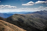
The Great Dividing Range, or the Eastern Highlands, is Australia
's most substantial mountain range and the third longest in the world. The range stretches more than 3,500 km (2,175 mi) from Dauan Island off the northeastern tip of Queensland, running the entire length of the eastern coastline through New South Wales
, then into Victoria
and turning west, before finally fading into the central plain at the Grampians in western Victoria. The width of the range varies from about 160 km to over 300 km.
The sharp rise between the coastal lowlands and the eastern uplands has affected Australia's climate, mainly due to orographic precipitation, and these areas of highest relief have revealed an impressive gorge country.
 The Dividing Range does not consist of a single mountain range. It consists of a complex of mountain ranges, plateaus, upland areas and escarpments with an ancient and complex geological history. The physiographic division name for the landmass is called the East Australian Cordillera.
The crest of the range is defined by the watershed or boundary between the drainage basin
s of rivers which drain directly eastward into the Pacific Ocean, or southward into Bass Strait
, and those rivers which drain into the Murray-Darling River system towards the west and north. In the north, the rivers on the west side of the range drain towards the Gulf of Carpentaria
.
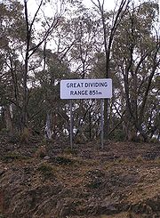
The higher and more rugged parts of the "range" do not necessarily form part of the crest of the range, but may be branches and offshoots from it. The term "Great Dividing Range" may refer specifically to the watershed crest of the range, or to the entire upland complex including all of the hills and mountains between the east coast of Australia and the central plains and lowlands. Notable ranges and other features which form part of the range complex have their own distinctive names.
—some 300 million years ago—when Australia collided with what is now parts of South America and New Zealand. The range has experienced significant erosion since. (See Geology of Australia
.)
Prior to white settlement the ranges were home to Australian Aboriginal
tribes. Evidence remains in some places of their occupation by decorated caves, campsites and trails used to travel between the coastal and inland regions.
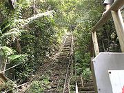
After European settlement in 1788, the ranges were an obstacle to exploration and settlement by the British settlers. Although not high, parts of the highlands were very rugged.
In 1813, a usable route was finally discovered directly westward from Sydney across the Blue Mountains to Bathurst
by the party of Gregory Blaxland
, which included William Lawson and William Charles Wentworth
. (Towns in the Blue Mountains were later named after each of these men.) This was the start of the development of the agricultural districts of inland New South Wales
. Easier routes to inland New South Wales were discovered towards Goulburn to the southwest, and westwards from Newcastle
.
Subsequent explorations were made across and around the ranges by Allan Cunningham
, John Oxley
, Hamilton Hume
, Paul Edmund Strzelecki, Ludwig Leichhardt
and Thomas Mitchell. These explorers were mainly concerned with finding good agricultural land.
By the late 1830s the most fertile rangelands adjacent to the mountains ranges had been explored and some settled. These included the Gippsland and Riverina regions in the south, up to the Liverpool Plains
and the Darling Downs in the north.
Various road and railway routes were subsequently established through many parts of the ranges, although many areas remain remote to this day. For example, in eastern Victoria there is only one major road crossing the highlands from north to south.
and Darling Downs in Queensland, and the Northern Tablelands, Southern Highlands
and Southern Tablelands
in New South Wales
. Other parts of the highlands are too rugged for agriculture and have been used for forestry. Many parts of the highlands which were not developed are now included in National Parks.
All of mainland Australia
's alpine areas, including its highest mountain, Mount Kosciuszko
(2,228 metres AHD
), are part of this range. The highest areas in southern New South Wales and eastern Victoria are known as the Australian Alps
.
The central core of the Great Dividing Range is dotted with hundreds of peaks and is surrounded by many smaller mountain ranges or spurs, canyon
s, valley
s and plains of regional significance. Some of the major plains include the High Plains
of South-Eastern Australia, the Southern Highlands the Central highlands
and Bogong High Plains
of Victoria. Other tablelands considered part of the Great dividing range are the Atherton Tableland
, Canberra wine region
and the Southern Tablelands
.
 The Dandenong Ranges
, Bunya Mountains
, Blue Mountains, Liverpool Range
, McPherson Range
s and the Moonbi Range
are some of the smaller spurs and ranges that make up the greater dividing range. Other notable ranges and tablelands which form part of the Great Dividing Range include the Liverpool Range
, Mount Royal Range
and the Monaro District
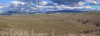
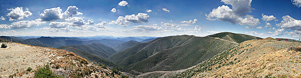
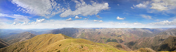
. Whilst some of the peaks of the highlands reach respectable heights of a little over 2,000 metres, the age of the range and its erosion mean that most of the mountains are not very steep, and virtually all peaks can be reached without mountaineering equipment.
In some areas, such as the Snowy Mountains
, Victorian Alps, the Scenic Rim
and the eastern escarpments of the New England
region, the highlands form a significant barrier. The eastern escarpment is the site of many spectacular waterfalls which were formed by rivers plunging off the tablelands. In other areas the slopes are gentle and in places the range is barely perceptible.
Well known passes on the range include Coxs Gap, Cunninghams Gap, Dead Horse Gap, Nowlands Gap
, and Spicers Gap.
 Notable towns located on the upland areas of the range include Atherton
, Toowoomba
, Armidale
, Oberon
, Goulburn
, Canberra
, Walcha
and Omeo
. Many other towns and cities are located in lowland areas and foothills adjacent to the highlands. There is a strong natural history and cultural attachment to the Dividing Range region in towns and on and many, sometimes remote landholdings.
.
Valleys along the chain of mountains have yielded a water source for important reservoirs and water supply projects such as the Upper Nepean Scheme
, Snowy Mountains Scheme
and Warragamba Dam
. The Bradfield Scheme
has been mooted as a way to transport water from the tropics in coastal Queensland south to dryer regions.
The Great Dividing Range creates the drainage basin
s of the Australian south-east coast drainage division
and the Australian north-east coast drainage division
, whose water flows to the east coast and into the Pacific Ocean, Tasman Sea
, and Bass Strait
with the westerly Murray-Darling Basin
which flow inland, away from the coast into the interior plains.
Some of the rivers which flow west of the ranges includes the Condamine River
, Flinders River
, Herbert River
, Lachlan River
, Macdonald River
, Macintyre River
and Namoi River
. Rivers that flow north into the Murray-Darling Basin from Victoria include the Goulburn, Mitta Mitta, Kiewa, Ovens. King, Loddon and Campaspe rivers. Rivers that flow east into the Pacific Ocean include the Brisbane River
, Burdekin River
, Clarence River
, Hastings River
, Hawkesbury River
, Hunter River, Macleay River
, Mary River
, Richmond River
, Shoalhaven River
and the Snowy River
. Those that flow south to the ocean in Victoria include the Snowy, Cann, Tambo, Mitchell, Latrobe, Thomson, Yarra, Werribee, Hopkins and Glenelg rivers.
such as the Alpine Way
, Great Alpine Road
, Hume Highway
, Great Western Highway
, Capricorn Highway
, Cunningham Highway
, New England Highway
, Oxley Highway
, Warrego Highway
, Waterfall Way
, Thunderbolts Way
, the Calder Highway
, the Western Highway
, and the Murray Valley Highway
traverse parts of the range.
s and other reserves
, most of the national parks are listed below, there are almost double the amount of state forests;
Australia
Australia , officially the Commonwealth of Australia, is a country in the Southern Hemisphere comprising the mainland of the Australian continent, the island of Tasmania, and numerous smaller islands in the Indian and Pacific Oceans. It is the world's sixth-largest country by total area...
's most substantial mountain range and the third longest in the world. The range stretches more than 3,500 km (2,175 mi) from Dauan Island off the northeastern tip of Queensland, running the entire length of the eastern coastline through New South Wales
New South Wales
New South Wales is a state of :Australia, located in the east of the country. It is bordered by Queensland, Victoria and South Australia to the north, south and west respectively. To the east, the state is bordered by the Tasman Sea, which forms part of the Pacific Ocean. New South Wales...
, then into Victoria
Victoria (Australia)
Victoria is the second most populous state in Australia. Geographically the smallest mainland state, Victoria is bordered by New South Wales, South Australia, and Tasmania on Boundary Islet to the north, west and south respectively....
and turning west, before finally fading into the central plain at the Grampians in western Victoria. The width of the range varies from about 160 km to over 300 km.
The sharp rise between the coastal lowlands and the eastern uplands has affected Australia's climate, mainly due to orographic precipitation, and these areas of highest relief have revealed an impressive gorge country.
Terminology
The crest of the range is defined by the watershed or boundary between the drainage basin
Drainage basin
A drainage basin is an extent or an area of land where surface water from rain and melting snow or ice converges to a single point, usually the exit of the basin, where the waters join another waterbody, such as a river, lake, reservoir, estuary, wetland, sea, or ocean...
s of rivers which drain directly eastward into the Pacific Ocean, or southward into Bass Strait
Bass Strait
Bass Strait is a sea strait separating Tasmania from the south of the Australian mainland, specifically the state of Victoria.-Extent:The International Hydrographic Organization defines the limits of the Bass Strait as follows:...
, and those rivers which drain into the Murray-Darling River system towards the west and north. In the north, the rivers on the west side of the range drain towards the Gulf of Carpentaria
Gulf of Carpentaria
The Gulf of Carpentaria is a large, shallow sea enclosed on three sides by northern Australia and bounded on the north by the Arafura Sea...
.
The higher and more rugged parts of the "range" do not necessarily form part of the crest of the range, but may be branches and offshoots from it. The term "Great Dividing Range" may refer specifically to the watershed crest of the range, or to the entire upland complex including all of the hills and mountains between the east coast of Australia and the central plains and lowlands. Notable ranges and other features which form part of the range complex have their own distinctive names.
History
The Great Dividing Range was formed during the Carboniferous periodCarboniferous
The Carboniferous is a geologic period and system that extends from the end of the Devonian Period, about 359.2 ± 2.5 Mya , to the beginning of the Permian Period, about 299.0 ± 0.8 Mya . The name is derived from the Latin word for coal, carbo. Carboniferous means "coal-bearing"...
—some 300 million years ago—when Australia collided with what is now parts of South America and New Zealand. The range has experienced significant erosion since. (See Geology of Australia
Geology of Australia
Australia is a continent situated on the Indo-Australian Plate.The geology of Australia includes virtually all known rock types and from all geological time periods spanning over 3.8 billion years of the Earth's history.-Components:...
.)
Prior to white settlement the ranges were home to Australian Aboriginal
Australian Aborigines
Australian Aborigines , also called Aboriginal Australians, from the latin ab originem , are people who are indigenous to most of the Australian continentthat is, to mainland Australia and the island of Tasmania...
tribes. Evidence remains in some places of their occupation by decorated caves, campsites and trails used to travel between the coastal and inland regions.
After European settlement in 1788, the ranges were an obstacle to exploration and settlement by the British settlers. Although not high, parts of the highlands were very rugged.
In 1813, a usable route was finally discovered directly westward from Sydney across the Blue Mountains to Bathurst
Bathurst, New South Wales
-CBD and suburbs:Bathurst's CBD is located on William, George, Howick, Russell, and Durham Streets. The CBD is approximately 25 hectares and surrounds two city blocks. Within this block layout is banking, government services, shopping centres, retail shops, a park* and monuments...
by the party of Gregory Blaxland
Gregory Blaxland
Gregory Blaxland was a pioneer farmer and explorer in Australia.- Early life :Gregory Blaxland was born 17 June 1778 at Fordwich, Kent, England, the fourth son of John Blaxland, mayor from 1767 to 1774, whose family had owned estates nearby for generations, and Mary, daughter of Captain Parker,...
, which included William Lawson and William Charles Wentworth
William Wentworth
William Charles Wentworth was an Australian poet, explorer, journalist and politician, and one of the leading figures of early colonial New South Wales...
. (Towns in the Blue Mountains were later named after each of these men.) This was the start of the development of the agricultural districts of inland New South Wales
New South Wales
New South Wales is a state of :Australia, located in the east of the country. It is bordered by Queensland, Victoria and South Australia to the north, south and west respectively. To the east, the state is bordered by the Tasman Sea, which forms part of the Pacific Ocean. New South Wales...
. Easier routes to inland New South Wales were discovered towards Goulburn to the southwest, and westwards from Newcastle
Newcastle, New South Wales
The Newcastle metropolitan area is the second most populated area in the Australian state of New South Wales and includes most of the Newcastle and Lake Macquarie Local Government Areas...
.
Subsequent explorations were made across and around the ranges by Allan Cunningham
Allan Cunningham (botanist)
Allan Cunningham was an English botanist and explorer, primarily known for his travels in New South Wales to collect plants.- Early life :...
, John Oxley
John Oxley
John Joseph William Molesworth Oxley was an explorer and surveyor of Australia in the early period of English colonisation.October 1802 he was engaged in coastal survey work including an expedition to Western Port in 1804-05...
, Hamilton Hume
Hamilton Hume
Hamilton Hume was the first Australian born explorer. Along with Hovell in 1824, Hume was part of an expedition that first took an overland route from Sydney to Port Phillip near the site of present day Melbourne...
, Paul Edmund Strzelecki, Ludwig Leichhardt
Ludwig Leichhardt
Friedrich Wilhelm Ludwig Leichhardt, known as Ludwig Leichhardt, was a Prussian explorer and naturalist, most famous for his exploration of northern and central Australia.-Early life:...
and Thomas Mitchell. These explorers were mainly concerned with finding good agricultural land.
By the late 1830s the most fertile rangelands adjacent to the mountains ranges had been explored and some settled. These included the Gippsland and Riverina regions in the south, up to the Liverpool Plains
Liverpool Plains
The Liverpool Plains is a geographical area and Local Government Area in the North West Slopes, New South Wales.The Shire was formed on 17 March 2004 by the amalgamation of Quirindi Shire with parts of three other shires: Parry, Murrurundi and Gunnedah.- Main towns :* Quirindi* Ardglen*...
and the Darling Downs in the north.
Various road and railway routes were subsequently established through many parts of the ranges, although many areas remain remote to this day. For example, in eastern Victoria there is only one major road crossing the highlands from north to south.
Notable components
Parts of the highlands consisting of relatively flat and, by Australian standards, well-watered land were developed for agricultural and pastoral uses. Such areas include the Atherton TablelandAtherton Tableland
The Atherton Tableland is a fertile plateau which is part of the Great Dividing Range in Queensland, Australia. It is located west to south-south-west inland from Cairns, well into the tropics, but its elevated position provides a climate suitable for dairy farming. It has an area of around...
and Darling Downs in Queensland, and the Northern Tablelands, Southern Highlands
Southern Highlands, New South Wales
The Southern Highlands, also locally referred to as the Highlands, is a geographical region and district in New South Wales, Australia and is 110 km south-west of Sydney. The entire region is under the local government area of the Wingecarribee Shire...
and Southern Tablelands
Southern Tablelands
The Southern Tablelands is a geographic area of the State of New South Wales, Australia. This area is located west of the Great Dividing Range.The area is characterised by flat country which has generally been extensively cleared and used for grazing purposes...
in New South Wales
New South Wales
New South Wales is a state of :Australia, located in the east of the country. It is bordered by Queensland, Victoria and South Australia to the north, south and west respectively. To the east, the state is bordered by the Tasman Sea, which forms part of the Pacific Ocean. New South Wales...
. Other parts of the highlands are too rugged for agriculture and have been used for forestry. Many parts of the highlands which were not developed are now included in National Parks.
All of mainland Australia
Australia (continent)
Australia is the world's smallest continent, comprising the mainland of Australia and proximate islands including Tasmania, New Guinea, the Aru Islands and Raja Ampat Islands...
's alpine areas, including its highest mountain, Mount Kosciuszko
Mount Kosciuszko
Mount Kosciuszko is a mountain located in the Snowy Mountains in Kosciuszko National Park. With a height of 2,228 metres above sea level, it is the highest mountain in Australia...
(2,228 metres AHD
Australian Height Datum
The Australian Height Datum is a geodetic datum for altitude measurement in Australia. According to Geoscience Australia, "In 1971 the mean sea level for 1966-1968 was assigned the value of zero on the Australian Height Datum at thirty tide gauges around the coast of the Australian continent...
), are part of this range. The highest areas in southern New South Wales and eastern Victoria are known as the Australian Alps
Australian Alps
The Australian Alps are the highest mountain ranges of mainland Australia. They are located in southeastern Australia and straddle the Australian Capital Territory, south-eastern New South Wales and eastern Victoria...
.
The central core of the Great Dividing Range is dotted with hundreds of peaks and is surrounded by many smaller mountain ranges or spurs, canyon
Canyon
A canyon or gorge is a deep ravine between cliffs often carved from the landscape by a river. Rivers have a natural tendency to reach a baseline elevation, which is the same elevation as the body of water it will eventually drain into. This forms a canyon. Most canyons were formed by a process of...
s, valley
Valley
In geology, a valley or dale is a depression with predominant extent in one direction. A very deep river valley may be called a canyon or gorge.The terms U-shaped and V-shaped are descriptive terms of geography to characterize the form of valleys...
s and plains of regional significance. Some of the major plains include the High Plains
High Plains (Australia)
The High Plains of South-Eastern Australia are a region, or more strictly a string of adjacent areas, in and adjacent to the Great Dividing Range. They were long used for summer grazing, in some cases since the 1830s. Much of the region is now National Park....
of South-Eastern Australia, the Southern Highlands the Central highlands
Central highlands (Victoria)
The Central Highlands is a region of Victoria. This term is mainly used in a geological context to describe the part of the Great Dividing Range in Victoria that is outside of the Alpine areas. The area is situated east of Ballarat, south of Bendigo, north and east of Melbourne, west of the Alpine...
and Bogong High Plains
Bogong High Plains
The Bogong High Plains are a section of the Alpine National Park in the Australian state of Victoria and are situated south of Mount Bogong. This area forms part of Australia's Great Dividing Range and in winter is one of the largest snow covered areas in the country. It can be easily accessed from...
of Victoria. Other tablelands considered part of the Great dividing range are the Atherton Tableland
Atherton Tableland
The Atherton Tableland is a fertile plateau which is part of the Great Dividing Range in Queensland, Australia. It is located west to south-south-west inland from Cairns, well into the tropics, but its elevated position provides a climate suitable for dairy farming. It has an area of around...
, Canberra wine region
Canberra wine region
The Canberra District wine region is located around Canberra, in the Capital city of Australia.Wine is grown and produced at or near and in a triangular area of about 60 km sides bordered by Canberra, Yass, and Bungendore, taking in the important localities of Murrumbateman and Lake...
and the Southern Tablelands
Southern Tablelands
The Southern Tablelands is a geographic area of the State of New South Wales, Australia. This area is located west of the Great Dividing Range.The area is characterised by flat country which has generally been extensively cleared and used for grazing purposes...
.
Dandenong Ranges
The Dandenong Ranges are a set of low mountain ranges, rising to 633 metres at Mount Dandenong, approximately 35 km east of Melbourne, Victoria, Australia...
, Bunya Mountains
Bunya Mountains
The Bunya Mountains are a distinctive set of peaks forming an isolated section of the Great Dividing Range in southern Queensland. The mountain range forms the northern edge of the Darling Downs near Bell and Dalby. The mountains are south of Kingaroy and just to the south west of Nanango...
, Blue Mountains, Liverpool Range
Liverpool Range
The Liverpool Range is a mountain range and a lava-field province in New South Wales, Australia.The Liverpool Range starts from the volcanic plateau known as the Barrington Tops and runs for about 100 km westwards, forming the northern boundary of the Hunter Valley district...
, McPherson Range
McPherson Range
The McPherson Range is an extensive mountain range, a spur of the Great Dividing Range, heading in an easterly direction from near Wallangarra to the Pacific Ocean coastline. It forms part of the Scenic Rim on the border between the states of New South Wales and Queensland. Further west of the...
s and the Moonbi Range
Moonbi Range
The Moonbi Range is a chain of hills which forms a part of the Northern Tablelands, New South Wales, Australia.The range is located roughly 20 kilometres north east of the city of Tamworth situated at the bottom of the Wentworth Mounds, which is part of the Moonbi Range. These mounds form a spur of...
are some of the smaller spurs and ranges that make up the greater dividing range. Other notable ranges and tablelands which form part of the Great Dividing Range include the Liverpool Range
Liverpool Range
The Liverpool Range is a mountain range and a lava-field province in New South Wales, Australia.The Liverpool Range starts from the volcanic plateau known as the Barrington Tops and runs for about 100 km westwards, forming the northern boundary of the Hunter Valley district...
, Mount Royal Range
Mount Royal Range
The Mount Royal Range is a mountain range in New South Wales, Australia. Prominent peaks in the range include Mount Polblue , Brumlow Tops , Gulph Mountain, Gog and Magog, The Pinnacle, Paddys Ridge, Mount William, Mount Paterson, Mount Allyn, Mount Royal , Mount Toonumbue, the Belgrave Pinnacle,...
and the Monaro District
Monaro, New South Wales
Monaro is the name of a region in the south of New South Wales, Australia. A small area of Victoria near Snowy River National Park is geographically part of the Monaro, whilst the Australian Capital Territory is frequently considered part of the region: most towns have very close links with...
. Whilst some of the peaks of the highlands reach respectable heights of a little over 2,000 metres, the age of the range and its erosion mean that most of the mountains are not very steep, and virtually all peaks can be reached without mountaineering equipment.
In some areas, such as the Snowy Mountains
Snowy Mountains
The Snowy Mountains, known informally as "The Snowies", are the highest Australian mountain range and contain the Australian mainland's highest mountain, Mount Kosciuszko, which reaches 2,228 metres AHD, approximately 7310 feet....
, Victorian Alps, the Scenic Rim
Scenic Rim
The Scenic Rim is a group of forested mountain ranges of the Great Dividing Range straddling the border between south-eastern Queensland and north-eastern New South Wales, Australia.-Description:...
and the eastern escarpments of the New England
New England (Australia)
New England or New England North West is the name given to a generally undefined region about 60 kilometres inland, that includes the Northern Tablelands and the North West Slopes regions in the north of the state of New South Wales, Australia.-History:The region has been occupied by Indigenous...
region, the highlands form a significant barrier. The eastern escarpment is the site of many spectacular waterfalls which were formed by rivers plunging off the tablelands. In other areas the slopes are gentle and in places the range is barely perceptible.
Well known passes on the range include Coxs Gap, Cunninghams Gap, Dead Horse Gap, Nowlands Gap
Nowlands Gap
Nowlands Gap, also known as Nowlands Pass and Murrurundi Gap, is a pass over the Liverpool Range in central NSW Australia.William Nowland discovered Nowlands Gap north of Murrurundi in 1827. His route eventually became part of the Great North Road...
, and Spicers Gap.
Atherton, Queensland
Atherton is a town on the Atherton Tablelands of Far North Queensland, Australia. At the 2006 census, Atherton had a population of 7,068.-Roads:...
, Toowoomba
Toowoomba, Queensland
Toowoomba is a city in Southern Queensland, Australia. It is located west of Queensland's capital city, Brisbane. With an estimated district population of 128,600, Toowoomba is Australia's second largest inland city and its largest non-capital inland city...
, Armidale
Armidale, New South Wales
Armidale is a city in the Northern Tablelands, New South Wales, Australia. Armidale Dumaresq Shire had a population of 19,485 people according to the 2006 census. It is the administrative centre for the Northern Tablelands region...
, Oberon
Oberon, New South Wales
-See also:*Oberon Correctional Centre*Mount Trickett*Mount Bindo*Shooters Hill-External links:***...
, Goulburn
Goulburn, New South Wales
Goulburn is a provincial city in the Southern Tablelands of New South Wales, Australia in Goulburn Mulwaree Council Local Government Area. It is located south-west of Sydney on the Hume Highway and above sea-level. On Census night 2006, Goulburn had a population of 20,127 people...
, Canberra
Canberra
Canberra is the capital city of Australia. With a population of over 345,000, it is Australia's largest inland city and the eighth-largest city overall. The city is located at the northern end of the Australian Capital Territory , south-west of Sydney, and north-east of Melbourne...
, Walcha
Walcha, New South Wales
Walcha is a parish and town at the south-eastern edge of the Northern Tablelands, New South Wales, Australia.The town serves as the seat of Walcha Shire. Walcha is located 425 kilometres by road from Sydney at the intersection of the Oxley Highway and Thunderbolts Way...
and Omeo
Omeo, Victoria
Omeo is a town in Victoria, Australia, located on the Great Alpine Road, east of Mount Hotham, in the Shire of East Gippsland. At the 2006 census, Omeo had a population of 452. The name is derived from the Aboriginal word for 'mountains' or 'hills'...
. Many other towns and cities are located in lowland areas and foothills adjacent to the highlands. There is a strong natural history and cultural attachment to the Dividing Range region in towns and on and many, sometimes remote landholdings.
Water catchments
The lower reaches are used for forestry, an activity that causes much friction with conservationists. The ranges is also the source of virtually all of eastern Australia's water supply, both through runoff caught in dams, and, throughout much of Queensland, through the Great Artesian BasinGreat Artesian Basin
The Great Artesian Basin provides the only reliable source of freshwater through much of inland Australia. The basin is the largest and deepest artesian basin in the world, stretching over a total of , with temperatures measured ranging from 30°C to 100°C...
.
Valleys along the chain of mountains have yielded a water source for important reservoirs and water supply projects such as the Upper Nepean Scheme
Upper Nepean Scheme
The Upper Nepean Scheme is a series of dams in the catchments of the Cataract, Cordeaux, Avon and Nepean rivers of New South Wales, Australia. The scheme includes four dams and supplies the Macarthur and Illawarra regions, the Wollondilly Shire, and metropolitan Sydney.- History :The Upper Nepean...
, Snowy Mountains Scheme
Snowy Mountains Scheme
The Snowy Mountains scheme is a hydroelectricity and irrigation complex in south-east Australia. It consists of sixteen major dams; seven power stations; a pumping station; and 225 kilometres of tunnels, pipelines and aqueducts and was constructed between 1949 and 1974. The Chief engineer was Sir...
and Warragamba Dam
Warragamba Dam
Warragamba Dam is the primary water source for the Australian city of Sydney. It is approximately to the west of Sydney on the Warragamba River, a tributary of the Hawkesbury River, and impounds Lake Burragorang.- Overview :...
. The Bradfield Scheme
Bradfield Scheme
The Bradfield Scheme is an inland irrigation project designed to irrigate and drought-proof much of the Queensland interior, as well as large areas of South Australia. It was devised by Dr John Job Crew Bradfield , a Queensland born civil engineer, who also designed the Sydney Harbour Bridge and...
has been mooted as a way to transport water from the tropics in coastal Queensland south to dryer regions.
The Great Dividing Range creates the drainage basin
Drainage basin
A drainage basin is an extent or an area of land where surface water from rain and melting snow or ice converges to a single point, usually the exit of the basin, where the waters join another waterbody, such as a river, lake, reservoir, estuary, wetland, sea, or ocean...
s of the Australian south-east coast drainage division
Australian south-east coast drainage division
The south-east coast drainage division is the very long, narrow area of southern Australia between the Great Dividing Range and the sea. It includes the small part of south-eastern South Australia which lies to the east of the Murray-Darling Basin, and all of coastal Victoria and coastal New South...
and the Australian north-east coast drainage division
Australian north-east coast drainage division
The north-east coast drainage division is the area of Queensland between the Great Dividing Range and the ocean. It lies between Torres Strait and an arbitrary line drawn along the Queensland - New South Wales border.-See also:...
, whose water flows to the east coast and into the Pacific Ocean, Tasman Sea
Tasman Sea
The Tasman Sea is the large body of water between Australia and New Zealand, approximately across. It extends 2,800 km from north to south. It is a south-western segment of the South Pacific Ocean. The sea was named after the Dutch explorer Abel Janszoon Tasman, the first recorded European...
, and Bass Strait
Bass Strait
Bass Strait is a sea strait separating Tasmania from the south of the Australian mainland, specifically the state of Victoria.-Extent:The International Hydrographic Organization defines the limits of the Bass Strait as follows:...
with the westerly Murray-Darling Basin
Murray-Darling Basin
The Murray-Darling basin is a large geographical area in the interior of southeastern Australia, whose name is derived from its two major rivers, the Murray River and the Darling River. It drains one-seventh of the Australian land mass, and is currently by far the most significant agricultural...
which flow inland, away from the coast into the interior plains.
Some of the rivers which flow west of the ranges includes the Condamine River
Condamine River
The Condamine River, part of the Murray-Darling Basin, drains the northern portion of the Darling Downs, an area of sub-coastal southern Queensland, Australia...
, Flinders River
Flinders River
The Flinders River is the longest river in Queensland, Australia at about . The river rises in the Burra Range, part of the Great Dividing Range, 110 km northeast of Hughenden and flows in a westerly direction past Hughenden, Richmond and Julia Creek then northwest to the Gulf of Carpentaria...
, Herbert River
Herbert River
The Herbert River is a river located in Far North Queensland, Australia. The southernmost of Queensland's wet tropics river systems, it is named after Robert George Wyndham Herbert , the first Premier of Queensland...
, Lachlan River
Lachlan River
- Course :The river rises in the central highland of New South Wales, part of the Great Dividing Range, 13 km east of Gunning. Its major headwaters, the Carcoar River, the Belubula River and the Abercrombie River converge near the town of Cowra. Minor tributaries include the Morongla Creek...
, Macdonald River
Macdonald River (Bendemeer)
There are two rivers named Macdonald River in New South Wales, Australia. See Macdonald RiverThe Macdonald River in northern New South Wales is the headwater of the Namoi River. It rises east of Niangala on the western slopes of the Great Dividing Range on the Northern Tablelands, New South Wales...
, Macintyre River
MacIntyre River
The Macintyre River is a river in northern New South Wales, Australia, part of which forms the border with Queensland.The headwaters of the Macintyre River rise west of Guyra and south of Glen Innes on the Northern Tablelands...
and Namoi River
Namoi River
The Namoi River is a major tributary of the Darling River in inland New South Wales, Australia.- Course :The headwaters of the Namoi, including the Macdonald River, the Peel River, the Cockburn River and the Manilla River, rise on the western slopes of the Great Dividing Range on the Northern...
. Rivers that flow north into the Murray-Darling Basin from Victoria include the Goulburn, Mitta Mitta, Kiewa, Ovens. King, Loddon and Campaspe rivers. Rivers that flow east into the Pacific Ocean include the Brisbane River
Brisbane River
The Brisbane River is the longest river in south east Queensland, Australia, and flows through the city of Brisbane, before emptying into Moreton Bay. John Oxley was the first European to explore the river who named it after the Governor of New South Wales, Thomas Brisbane in 1823...
, Burdekin River
Burdekin River
The Burdekin River in Queensland, Australia rises on the western slope of the Seaview Range and flows into the Pacific Ocean at Upstart Bay over 200 km to the southeast of the source. The river was first encountered by Europeans during the expedition led by Ludwig Leichhardt in 1845 and named...
, Clarence River
Clarence River (New South Wales)
The Clarence River is situated in northeastern New South Wales, Australia. The river originates on the watershed that marks the Queensland border. After flowing south and northeast for 394 km it then empties into the Pacific Ocean at Iluka/Yamba. On its journey it passes through the towns of...
, Hastings River
Hastings River
The Hastings River is a large river on the Mid North Coast of the Australian state of New South Wales that empties into the Tasman Sea, a branch of the South Pacific Ocean, at Port Macquarie....
, Hawkesbury River
Hawkesbury River
The Hawkesbury River, also known as Deerubbun, is one of the major rivers of the coastal region of New South Wales, Australia. The Hawkesbury River and its tributaries virtually encircle the metropolitan region of Sydney.-Geography:-Course:...
, Hunter River, Macleay River
Macleay River
The Macleay River is a major river on the Mid North Coast , Australia.The headwaters of the Macleay River rise as the Gara River on the eastern side of the Northern Tablelands near Armidale and Walcha, New South Wales. From here the Chandler River, Styx River and Apsley Rivers are important...
, Mary River
Mary River (Queensland)
The Mary River is a river system in South East Queensland, Australia. The river rises at Booroobin in the Sunshine Coast hinterland, west of Landsborough...
, Richmond River
Richmond River
The Richmond River is a river in the north-eastern corner of New South Wales, Australia. It runs for approximately 170 km from the foothills of the Border Ranges past the towns of Kyogle, Casino, Coraki, Woodburn, where it turns northward and empties into the Pacific Ocean at Ballina. It has a...
, Shoalhaven River
Shoalhaven River
The Shoalhaven River is a river rising from the Southern Tablelands and flowing into the ocean near Nowra on the South Coast of New South Wales, Australia.- History :...
and the Snowy River
Snowy River
The Snowy River is a major river in south-eastern Australia. It originates on the slopes of Mount Kosciuszko, Australia's highest mainland peak, draining the eastern slopes of the Snowy Mountains in New South Wales, before flowing through the Snowy River National Park in Victoria and emptying into...
. Those that flow south to the ocean in Victoria include the Snowy, Cann, Tambo, Mitchell, Latrobe, Thomson, Yarra, Werribee, Hopkins and Glenelg rivers.
Features
Railways
The engineers of early rail passages across the Great Dividing Range needed to find low sections of the range to cross, as well as suitable, low gradient paths up the mountains on either side. Rail passages include:- Ipswich-Toowoomba (1867)
- Newcastle-TamworthMain North railway line, New South WalesThe Main North Line is a major railway in New South Wales, Australia. It runs through the Central Coast, Hunter and the New England regions. The line was the original main line between Sydney and Brisbane, however this required a change of gauge at Wallangarra...
(c1870) – summit at Ardglen TunnelArdglen TunnelThe Ardglen Tunnel is a summit tunnel on the Main North railway in New South Wales, Australia, between Newcastle and Werris Creek. It crosses under the Liverpool Range near its east end below Nowlands Gap , the crossing used by the New England Highway.It is approximately 500 metres long, and... - Sydney-LithgowMain Western railway line, New South WalesThe Main Western Railway is a major railway in New South Wales, Australia. It runs through the Blue Mountains, Central West, North West Slopes and the Far West regions.- Description of route :...
(1869), crossing the range via the Blue Mountains - Sydney-GoulburnMain Southern railway line, New South WalesThe Main Southern Railway is a major railway in New South Wales, Australia. It runs through the Southern Highlands, Southern Tablelands, South West Slopes and the Riverina regions.- Description of route :...
(1869), though the divide is actually a few kilometres further west near the crossing with Parkesbourne Road. The next 300 km descending to Wagga Wagga is particularly curvy. - Melbourne-Seymour, crossing the range near Heathcote JunctionHeathcote Junction railway station, VictoriaHeathcote Junction is a railway station on the North East railway in the town of Heathcote Junction, Victoria, Australia. It is only two kilometres from Wandong station, an oddity on the Victorian country railway network...
(1872) - Melbourne-Bendigo, crossing the range near WoodendWoodend, VictoriaWoodend is a small town in Victoria, Australia. The town is in the Shire of Macedon Ranges Local government area. It is bypassed to the east and north by the Calder Freeway and is located about halfway between Melbourne and Bendigo...
(1862) - Melbourne-Ararat (1875) via BallaratBallarat, VictoriaBallarat is a city in the state of Victoria, Australia, approximately west-north-west of the state capital Melbourne situated on the lower plains of the Great Dividing Range and the Yarrowee River catchment. It is the largest inland centre and third most populous city in the state and the fifth...
Road transport
Many of Australia's highwaysHighways in Australia
This is a list of highways in Australia, listed alphabetically along with each highway's route number and location. Note that some highways service more than one state or territory.-Route numbering systems:...
such as the Alpine Way
Alpine Way
The Alpine Way is a State highway in New South Wales, Australia.The Alpine Way starts near Jindabyne on the eastern side of the Snowy Mountains. It runs south-west past Thredbo and crosses the crest of the Great Dividing Range at Dead Horse Gap...
, Great Alpine Road
Great Alpine Road
The Great Alpine Road is a country tourist road in Victoria, Australia, running from Wangaratta in the north to Bairnsdale in the east, and passing through the Australian Alps...
, Hume Highway
Hume Highway
The Hume Highway/Hume Freeway is one of Australia's major inter-city highways, running for 880 km between Sydney and Melbourne. It is part of the Auslink National Network and is a vital link for road freight to transport goods to and from the two cities as well as serving Albury-Wodonga and...
, Great Western Highway
Great Western Highway
The Great Western Highway is a highway in New South Wales, Australia. It runs 210 km from Sydney to Bathurst.Starting as Broadway at the intersection of City Road near the fringe of the Sydney CBD, and becoming Parramatta Road to Parramatta itself, the Great Western Highway heads due west from...
, Capricorn Highway
Capricorn Highway
The Capricorn Highway is located in Central Queensland, Australia, and links the city of Rockhampton with western Queensland. The highway is approximately 560 kilometres long, and joins the Landsborough Highway at Barcaldine...
, Cunningham Highway
Cunningham Highway
The Cunningham Highway is a National Highway in Queensland, Australia. It is named after the explorer and botanist Allan Cunningham who followed a route close to where the modern day highway runs.-Route:...
, New England Highway
New England Highway
The New England Highway is a highway in Australia running from Hexham near Newcastle at its southern end to Yarraman near Toowoomba at its northern end. At its southern end it connects to the Pacific Highway and at its northern end it connects to the D'Aguilar Highway. It traverses the Hunter...
, Oxley Highway
Oxley Highway
The Oxley Highway is a rural highway in New South Wales, Australia. It starts at Nevertire where it joins the Mitchell Highway. It links Warren, Gilgandra, Coonabarabran, Gunnedah, Carroll, Tamworth, Bendemeer, Walcha, Yarrowitch, Ellenborough, Long Flat, Wauchope and ends at Port Macquarie on the...
, Warrego Highway
Warrego Highway
The Warrego Highway is located in southern Queensland, Australia. It connects coastal centres to the south western areas of the state, and is approximately 750 km in length. It takes its name from the Warrego River, which is the endpoint of the highway...
, Waterfall Way
Waterfall Way
The Waterfall Way is a road and State Highway 78 in New South Wales, Australia. It runs east-west from the Pacific Highway to the New England Highway at Armidale. The route passes through some of New South Wales' most scenic countryside and has become well known as New South Wales best and...
, Thunderbolts Way
Thunderbolts Way
Thunderbolts Way is a New South Wales country road linking Gloucester to Walcha , Uralla, where it very briefly joins the New England Highway and, to Copes Creek, south of the Gwydir Highway intersection at Inverell...
, the Calder Highway
Calder Highway
Calder Highway is a Highway linking Ravenswood South in Victoria, to Mildura. North of the Victoria/New South Wales border, the highway continues north to Broken Hill, Tibooburra and the New South Wales/Queensland border as the Silver City Highway, under the standard national route shield as far...
, the Western Highway
Western Highway
Western Highway may refer to:*Western Highway, Victoria in Australia*Western Highway...
, and the Murray Valley Highway
Murray Valley Highway
The Murray Valley Highway is a popular tourist route, which follows the south side of the Murray River in Victoria, Australia. The route effectively acts as the northern-most highway in Victoria...
traverse parts of the range.
Protected areas
Much of the range lies within a succession of national parkNational park
A national park is a reserve of natural, semi-natural, or developed land that a sovereign state declares or owns. Although individual nations designate their own national parks differently A national park is a reserve of natural, semi-natural, or developed land that a sovereign state declares or...
s and other reserves
Protected areas of Australia
Protected areas of Australia include Commonwealth and off-shore protected areas managed by the Australian government, as well as protected areas within each of the six states of Australia and two self-governing territories , which are managed by the eight state and territory...
, most of the national parks are listed below, there are almost double the amount of state forests;
- Alpine National ParkAlpine National ParkThe Alpine National Park is a national park in Victoria , northeast of Melbourne. It covers much of the higher areas of the Great Dividing Range in Victoria, including Victoria's highest point, Mount Bogong and the associated subalpine woodland and grassland of the Bogong High Plains...
– VIC - Bald Rock National ParkBald Rock National ParkBald Rock National Park is a national park in northern New South Wales, Australia, just north of Tenterfield on the Queensland border. On the other side of the border the national park continues as the Girraween National Park....
– NSW - Barrington Tops National ParkBarrington Tops National ParkBarrington Tops is a National Park in the Hunter Valley, approximately north of Sydney in New South Wales, Australia. The nearest towns are Scone, Singleton, Dungog, Gloucester and East Gresford....
– NSW - Baw Baw National ParkBaw Baw National ParkBaw Baw is a national park in Victoria, Australia, 111 km east of Melbourne. It contains the Baw-Baw Plateau and Mount Baw Baw, a small ski resort, including nearby town, technically outside the national park....
– VIC - Blue Mountains National ParkBlue Mountains National ParkThe Blue Mountains National Park is a national park in New South Wales, Australia, 81 km west of Sydney, and located in the Blue Mountains region of the Great Dividing Range. The park covers 268,987 hectares. The boundary of the park is quite irregular as it is broken up by roads, urban areas...
– NSW - Border Ranges National ParkBorder Ranges National ParkBorder Ranges National Park, 150 km south of Brisbane, Australia, is in northern New South Wales with a small portion located in Queensland....
– NSW - Brindabella National ParkBrindabella National ParkBrindabella National Park is a national park in New South Wales, Australia, 267 km southwest of Sydney in the Brindabella Ranges.On 7 November 2008 The Park was added to the Australian National Heritage List as one of eleven areas constituting the Australian Alps National Parks and...
– NSW - Brisbane Ranges National ParkBrisbane Ranges National ParkThe Brisbane Ranges National Park is a national park in Anakie, Victoria, Australia, 80 km west of Melbourne. The park is the responsibility of Parks Victoria. The park covers part of the Brisbane Ranges, an area of hills of moderate elevation. The park features a number of walking tracks, of...
– VIC - Budawang National ParkBudawang National ParkBudawang is a national park in New South Wales, Australia, 200 km southwest of Sydney. It contains part of the Budawang Mountain Range....
– NSW - Bunya Mountains National ParkBunya Mountains National ParkBunya Mountains is a national park in Queensland, Australia. The park includes much of the mountain range called the Bunya Mountains. The mountains are covered by the most westerly forests in southern Queensland and the largest area of bunya pines remaining in the world...
– QLD - Burrowa-Pine Mountain National ParkBurrowa-Pine Mountain National ParkBurrowa-Pine Mountain is a national park in Victoria, Australia, 314 km northeast of Melbourne. The park is the location of Pine Mountain, Victoria the largest monolith in the southern hemisphere at 1.5 times the size of Uluru ....
– VIC - Cathedral Rock National ParkCathedral Rock National ParkCathedral Rock is a national park eight kilometres west of Waterfall Way in New South Wales, Australia, 70 kilometres east of Armidale and about 555 kilometres north of Sydney....
– NSW - Conondale National ParkConondale National ParkConondale is a national park in Queensland, Australia, 98 km northwest of Brisbane.-External links:*...
– QLD - Cunnawarra National ParkCunnawarra National ParkCunnawarra is a national park in New South Wales, Australia, 80 km east of Armidale, 10 km off the Waterfall Way and 565 km north of Sydney. The 25 kilometre Styx River Forest Way runs from the Point Lookout Road through Cunnawarra National Park to the Kempsey Road...
– NSW - Dandenong Ranges National ParkDandenong Ranges National ParkDandenong Ranges National Park is in Victoria, Australia, 38 km east of Melbourne.Because the park is located in an urban area, the park has a long history of major problems with feral and roaming animals...
– VIC - Deua National ParkDeua National ParkDeua is a national park in New South Wales, Australia, 320 kilometres south of Sydney, and 100 kilometres east of Canberra. The nearest towns on the coast are Batemans Bay, Moruya and Narooma....
– NSW
- Dharug National ParkDharug National ParkDharug National Park is a national park in New South Wales , 58 km north of Sydney.-Fact sheet:*Area: 152 km²*Coordinates: *Date of establishment: October 1, 1967...
– NSW - Gibraltar Range National ParkGibraltar Range National ParkGibraltar Range is a national park in north-eastern New South Wales, Australia, 79 km north-east of Glen Innes and 493 km north of Sydney...
– NSW - Girraween National ParkGirraween National ParkGirraween National Park is an area of the Granite Belt in south-east Queensland, Australia reserved as a national park. Girraween is known for its spectacular flowers, dramatic landscapes and unique wildlife. Bushwalking and rock climbing are the most popular activities in the park.-Location:The...
– QLD/NSW - Grampians National ParkGrampians National ParkThe Grampians National Park is a national park in Victoria, Australia, 235 kilometres west of Melbourne. The Park was listed on the Australian National Heritage List on 15 December 2006 for its outstanding natural beauty and being one of the richest indigenous rock art sites in south-eastern...
– VIC - Guy Fawkes River National ParkGuy Fawkes River National ParkGuy Fawkes River National Park is on Waterfall Way near Ebor, New South Wales, 50 kilometres west of Dorrigo and 80 km north-east of Armidale in Australia...
– NSW - Heathcote-Graytown National Park
- Kanangra-Boyd National ParkKanangra-Boyd National ParkKanangra-Boyd is a national park in New South Wales, Australia, 100 km west of Sydney. It lies to the southwest of and is contiguous with the Blue Mountains National Park, and is part of the Greater Blue Mountains Area World Heritage Site ....
– NSW - Kosciuszko National ParkKosciuszko National ParkKosciuszko National Park covers 690,000 hectares and contains mainland Australia's highest peak, Mount Kosciuszko for which it is named, and Cabramurra the highest town in Australia...
– NSW - Lake Eildon National ParkLake Eildon National ParkLake Eildon National Park is a national park in Victoria in the northern foothills of Victoria's Central Highlands, 111 km northeast of Melbourne...
– VIC - Lamington National ParkLamington National ParkLamington is a national park in Queensland, Australia, lying on the Lamington Plateau of the McPherson Range on the Queensland/New South Wales border...
– QLD - Morton National ParkMorton National ParkMorton is a national park in New South Wales , 170 km southwest of Sydney.The most notable attractions are the Fitzroy Falls, just off the main road from the Highlands to Kangaroo Valley and Pigeon House Mountain west of Milton. The park consists mostly of a flat plateau dissected by steep...
– NSW - Mount Buffalo National ParkMount Buffalo National ParkMount Buffalo is a mountain plateau in Victoria , 200 km northeast of Melbourne. It is one of the oldest parks in the Australian Alps, being first established in 1898 when 1165 ha was reserved around Eurobin Falls...
– VIC - Mummel Gulf National ParkMummel Gulf National ParkMummel Gulf is a national park in New South Wales , about 487 kilometres by road north of Sydney. It is situated approximately 50 km southeast of Walcha on the unsealed Enfield Forest Road and 12 km south of the Oxley Highway....
– NSW - Namadgi National ParkNamadgi National ParkNamadgi National Park is located in the southwestern part of the Australian Capital Territory, bordering Kosciuszko National Park in New South Wales. It lies approximately 40 km southwest of Canberra, and makes up approximately 46% of the ACT's land area....
– ACT - Nattai National ParkNattai National ParkNattai is a national park in New South Wales , 150 km southwest of Sydney. It is part of the Greater Blue Mountains World Heritage Area, and primarily encompasses the valley of the Nattai River, which is surrounded by spectacular sandstone cliffs. The park is covered in dry sclerophyll forest...
– NSW - New England National ParkNew England National ParkNew England National Park is situated on the Northern Tablelands in the New England region of New South Wales, Australia, 560 km north of Sydney. It is about 10 km south of Waterfall Way, just 85 km east of Armidale and 65 km west of Coffs Harbour...
– NSW
- Nowendoc National ParkNowendoc National ParkNowendoc National Park is a park on the southern end of the Northern Tablelands and west of Nowendoc, New South Wales, Australia. It is located approximately 70 km south of Walcha and about 375 km north of Sydney....
– NSW - Oxley Wild Rivers National ParkOxley Wild Rivers National ParkOxley Wild Rivers National Park is in New South Wales, Australia, 445 kilometres north of Sydney and is named in memory of the Australian explorer John Oxley, who passed through the area in 1818...
– NSW - Snowy River National ParkSnowy River National ParkSnowy River is a national park in Victoria , 323 km east of Melbourne.Much of the park is classified as wilderness area, where vehicles are unable to visit. The park provides one of the last natural habitats at the Little River Gorge for the endangered brush-tailed rock wallaby...
– VIC - South East Forest National ParkSouth East Forest National ParkSouth East Forest is a national park in New South Wales , 378 km southwest of Sydney. It features high quality old growth eucalyptus forest and remnant patches of temperate rainforest....
– NSW - Springbrook National ParkSpringbrook National ParkSpringbrook National Park is a national park at Springbrook on the McPherson Range in the Gold Coast hinterland of Queensland, , 96 km south of Brisbane. It is part of the Shield Volcano Group of the World Heritage site Gondwana Rainforests of Australia...
- QLD - Sundown National ParkSundown National ParkSundown is a national park in Queensland, Australia, 198 km southwest of Brisbane. The parks contains spectacular gorge country and a number of peaks higher than 1,000 m.-Landforms:...
– QLD - Toonumbar National ParkToonumbar National ParkToonumbar is a national park in New South Wales, Australia, 617 km north of Sydney.The Park is part of the Focal Peak Group World Heritage Site Gondwana Rainforests of Australia inscribed in 1986 and added to the Australian National Heritage List in 2007.-Description:The park features...
– NSW - Wadbilliga National ParkWadbilliga National ParkWadbilliga National Park is in south-eastern New South Wales Australia, 425 km southwest of Sydney via Cobargo, and 150 km south east of Canberra. The nearest towns are Narooma and Cobargo in the east, and Cooma on the plateau in the west....
– NSW - Washpool National ParkWashpool National ParkThe Washpool National Park is a national park in New South Wales, Australia, 516 km north of Sydney. The park is 586.78 km2 in size, has two campgrounds and is managed by the New South Wales National Parks and Wildlife Service...
– NSW - Werrikimbe National ParkWerrikimbe National ParkWerrikimbe National Park is in the catchment zone of the Upper Hastings River, New South Wales, Australia, about 486 km north of Sydney. This national park is about 80 km west of Wauchope and 90 km east of Walcha on the eastern escarpment of the Great Dividing Range...
– NSW - Wollemi National ParkWollemi National ParkWollemi National Park is the second largest national park in New South Wales, and contains most of the largest wilderness area, the Wollemi Wilderness...
– NSW - Yarra Ranges National ParkYarra Ranges National ParkYarra Ranges is a national park in Victoria, Australia, 92 km east of Melbourne. It covers the headwaters of the Yarra River in the ranges themselves and several water catchments for Melbourne's domestic water supply....
– VIC - Yengo National ParkYengo National ParkYengo is a national park in New South Wales, Australia, 132 km northwest of Sydney.In 1993 the National Park and Wildlife Service opened their depot in Bucketty. From here they started to manage the newly established Yengo National Park...
– NSW