

County Antrim
Encyclopedia
County Antrim is one of six counties
that form Northern Ireland
, situated in the north-east of the island of Ireland
. Adjoined to the north-east shore of Lough Neagh
, the county covers an area of 2,844 km², with a population of approximately 616,000. It is also one of the thirty-two traditional counties of Ireland
, lying within the historical province
of Ulster
.
The Glens of Antrim
offer isolated rugged landscapes, the Giant's Causeway
is a unique landscape and a UNESCO World Heritage site
, Bushmills
produces legendary whiskey, and Portrush
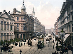
is a popular seaside resort and night-life area. The majority of the capital city of Northern Ireland, Belfast
, is also in County Antrim, with the remainder being in County Down.

 A large portion of Antrim is hilly, especially in the east, where the highest elevations are attained. The range runs north and south, and, following this direction the highest points are Knocklayd 514 m (1,686.4 ft), Slieveanorra 508 m (1,666.7 ft), Trostan 550 m (1,804.5 ft), Slemish
437 m (1,433.7 ft), Agnew's Hill 474 m (1,555.1 ft) and Divis 478 m (1,568.2 ft). The inland slope is gradual, but on the northern shore the range terminates in abrupt and almost perpendicular declivities, and here, consequently, some of the finest coast scenery in the world is found, widely differing, with its unbroken lines of cliffs, from the indented coast-line of the west. The most remarkable cliffs are those formed of perpendicular basaltic columns, extending for many miles, and most strikingly displayed in Fair Head
and the celebrated Giant's Causeway
. From the eastern coast the hills rise instantly but less abruptly, and the indentations are wider and deeper. On both coasts there are several resort towns, including Portrush
(with well-known golf links), Portballintrae
and Ballycastle
; on the east Cushendun
, Cushendall
and Waterfoot
on Red Bay, Carnlough
and Glenarm
, Larne
on the Sea of Moyle, and Whitehead on Belfast Lough. All are somewhat exposed to the easterly winds prevalent in spring. The only island of size is the L-shaped Rathlin Island
, off Ballycastle, 11 km (6.8 mi) in total length by 2 km (1.2 mi) maximum breadth, 7 km (4.3 mi) from the coast, and of similar basaltic and limestone formation to that of the mainland. It is partially arable, and supports a small population. Islandmagee
is in fact a peninsula separating Larne Lough
from the North Channel
.
The valleys of the Bann and Lagan, with the intervening shores of Lough Neagh, form the fertile lowlands. These two rivers, both rising in County Down, are the only ones of importance. The latter flows to Belfast Lough, the former drains Lough Neagh, which is fed by a number of smaller streams. The fisheries of the Bann and of Lough Neagh (especially for salmon
and eels) are of value both commercially and to sportsmen, the small town of Toome
, at the outflow of the river, being the centre. Immediately below this point lies Lough Beg, the "Small Lake," about 4.5 m (14.8 ft) lower than Lough Neagh.
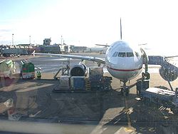
, at Aldergrove is in County Antrim. Belfast International shares its runways with the Royal Air Force
base RAF Aldergrove
, which otherwise has its own facilities. It is the fifth largest regional air cargo centre in the UK. There are regular services to Great Britain
, Europe
and North America
.
The region is also served by George Best Belfast City Airport
, a mile east of Belfast city centre
on the County Down side of the city, which was renamed in 2006 in honour of footballer George Best
.
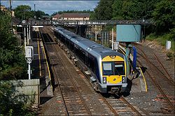
Northern Ireland Railways
routes are the major line between Belfast, Antrim, Ballymena
, Coleraine
and Londonderry
, Belfast to Carrickfergus
and Larne
, the port for Stranraer
in Scotland and Coleraine to Portrush
.
and Belfast
.
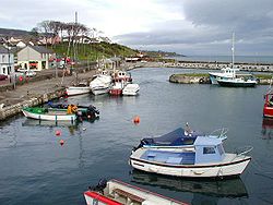
Ferries sail from Larne Harbour to destinations including Cairnryan
and Troon
in Scotland
, and Fleetwood
in England
.
The Port of Belfast
is Northern Ireland's principal maritime gateway, serving the Northern Ireland economy and increasingly that of the Republic of Ireland. It is a major centre of industry and commerce and has become established as the focus of logistics activity for Northern Ireland. Around two thirds of Northern Ireland's seaborne trade, and a quarter of that for Ireland as a whole, is handled at the port which receives over 6,000 vessels each year.
information. It is one of two counties
of Northern Ireland to presently have a majority of the population from a Protestant community background, according to the 2001 census
(the other being County Down
), and it is the most populous county in Northern Ireland.
is the largest religious denomination, followed by Catholic Church and Church of Ireland
. County Antrim is one of two counties in Ireland
in which the majority of people are Protestant, the other being Down
. The strong Presbyterian presence in the county is due largely to the county's historical links with lowland Scotland.
. More recently, Ballymena
was the seat of county government. The counties of Northern Ireland ceased to be administrative entities in 1973, with the reorganization of local government.
In Northern Ireland the county structure is no longer used in local government. Northern Ireland is split into districts
. The majority of County Antrim residents are administered by the following nine councils:
Small portions of the county are administered by councils that are based in neighbouring counties, notably the village of Aghagallon
in the Craigavon Borough
and the town of Portrush
in the Coleraine Borough
.
The county contains all of five parliamentary
constituencies:
Parts of the following constituencies are also in County Antrim:
Parishes
Townlands
 At what date the county of Antrim was formed is not known, but it appears that a certain district bore this name before the reign of Edward II
(early 14th century), and when the shiring of Ulster was undertaken by Sir John Perrot
in the 16th century, Antrim and Down were already recognized divisions, in contradistinction to the remainder of the province. The earliest known inhabitants were Mesolithic
hunter-gatherers of pre-Celt
ic origin, but the names of the townlands or subdivisions, supposed to have been made in the 13th century, are all of Gaelic derivation.
In ancient times, Antrim was inhabited by a Celtic people called the Darini
. In the early Middle Ages, southern County Antrim was part of the Kingdom of Ulidia
, ruled by the Dál Fiatach
clans Keenan and MacDonlevy/McDunlavey; the north was part of Dál Riada, which stretched into what is now western Scotland over the Irish Sea. Dál Riada was ruled by the O'Lynch clan, who were vassals of the Ulidians. Besides the Ulidians and Dál Riada, there were the Dál nAraide of lower County Antrim, and the Cruthin
, who were pre-Gaelic Celts and probably related to the Picts of Britain. Between the 8th and 11th centuries Antrim was exposed to the inroads of the Vikings.
In the late 12th century Antrim became part of the Earldom of Ulster, conquered by Anglo-Norman
adventurers. A revival of Gaelic power followed the campaign of Edward Bruce
in 1315, leaving Carrickfergus
as the only significant English stronghold. In the late Middle Ages, Antrim was divided into three parts: northern Clandeboye, the Glynnes and the Route. The Cambro-Norman
MacQuillans were powerful in the Route. A branch of the O'Neills of Tyrone migrated to Clandeboye in the 14th century, and ruled it for a time. Their family was called O'Neill Clannaboy. A Gallowglass
sept, the MacDonnells, became the most powerful in the Glynnes in the 15th century.
During the Tudor era, numerous adventurers from Britain attempted to colonize the region; many Scots settled in Antrim around this time. In 1588 the Antrim coast was the scene of one of the 24 wrecks of the Spanish Armada in Ireland
. The Spanish vessel La Girona
was wrecked off Lacana Point, Giant's Causeway in 1588 with the loss of nearly 1,300 lives.
Antrim is divided into sixteen baronies. Lower Antrim, part of Lower Clandeboye, was settled by the sept O'Flynn/O'Lynn. Upper Antrim, part of Lower Clandeboye, was the home of the O'Keevans. Belfast was part of Lower Clandeboye and was held by the O'Neill-Clannaboys. Lower Belfast, Upper Belfast, and Carrickfergus were also part of Lower Clandeboye. Cary was part of the Glynnes; ruled originally by the O'Quinn sept, the MacDonnell galloglasses from Scotland took power here in the late Middle Ages and some of the O'Haras also migrated from Connaught
. Upper and Lower Dunluce
were part of the Route, and were ruled by the MacQuillans. Upper and Lower Glenarm
was ruled by the O'Flynn/O'Lynn sept, considered part of the Glynns. In addition to that sept and that of O'Quinn, both of which were native, the Scottish Gallowglass
septs of MacKeown, MacAlister, and MacGee, are found there. Kilconway was originally O'Flynn/O'Lynn territory, but was held by the MacQuillans as part of the Route, and later by the gallowglass
sept of MacNeill. Lower Massereene was part of Lower Clandeboye and was ruled by the O'Flynns and the O'Heircs. Upper Massereene was part of Lower Clandeboye, ruled by the O'Heircs. Upper and Lower Toome, part of the Route, were O'Flynn/O'Lynn territory. Misc was first ruled by the MacQuillans. Later, the Scottish Gallowglass MacDonnells and MacAlisters invaded. The MacDonnells were a branch of the Scottish Clan MacDonald; the MacAlisters traced their origin back to the Irish Colla Uais, eldest of the Three Collas.
Islandmagee
had, besides antiquarian remains, a notoriety as a home of witchcraft, and during the Irish Rebellion of 1641
was the scene of an act of reprisal (for the massacre of Protestants
) against the Catholic population by the Scottish Covenanter
soldiery of Carrickfergus
.
 The antiquities of the county consist of cairn
s, mounts or forts, remains of ecclesiastical and military structures, and round tower
s.
There are three round towers: one at Antrim, one at Armoy
, and one on Ram's Island
in Lough Neagh, only that at Antrim being perfect. There are some remains of the ecclesiastic establishments at Bonamargy
, where the earls of Antrim are buried, Kells
, Glenarm, Glynn
, Muckamore and Whiteabbey.
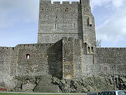
The castle at Carrickfergus
, dating from the Norman invasion of Ireland
, is one of the best preserved medieval structures in Ireland. There are, however, remains of other ancient castles, as Olderfleet
, Cam's, Shane's
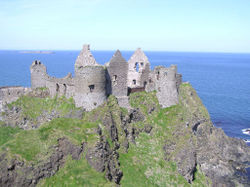
, Glenarm, Garron Tower, Red Bay, and Dunluce Castle
, notable for its dramatic location on a rocky outcrop.
The principal cairns are: one on Colin mountain, near Lisburn; one on Slieve True
, near Carrickfergus; and two on Colinward. The cromlech
s most worthy of notice are: one near Cairngrainey, to the north-east of the old road from Belfast to Templepatrick
; the large cromlech at Mount Druid, near Ballintoy
; and one at the northern extremity of Islandmagee. The mounts, forts and entrenchments are very numerous.
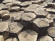
The natural rock formations of Giant's Causeway
on the Antrim coast are now designated a UNESCO
World Heritage Site
.
, about eight miles (13 km) east of Ballymena, is notable as being the scene of St Patrick's early life. According to tradition Saint Patrick
was a slave for seven years, near the hill of Slemish, until he escaped back to Great Britain
.
manufacturing was previously an important industry in the County. At the time Ireland produced a large mount of flax
. Cotton-spinning by jennies
was first introduced by to Belfast by industrialists Robert Joy and Thomas M'Cabe in 1777; an Twenty-three years later it was estimated that more than 27,000 people were employed in the industry within ten miles (16 km) of Belfast. Women were employed in the working of patterns on muslin
.
Counties of Northern Ireland
The counties of Northern Ireland were the principal local government divisions of Northern Ireland from its creation in 1921 until 1972 when their governmental features were abolished and replaced with twenty-six unitary authorities....
that form Northern Ireland
Northern Ireland
Northern Ireland is one of the four countries of the United Kingdom. Situated in the north-east of the island of Ireland, it shares a border with the Republic of Ireland to the south and west...
, situated in the north-east of the island of Ireland
Ireland
Ireland is an island to the northwest of continental Europe. It is the third-largest island in Europe and the twentieth-largest island on Earth...
. Adjoined to the north-east shore of Lough Neagh
Lough Neagh
Lough Neagh, sometimes Loch Neagh, is a large freshwater lake in Northern Ireland. Its name comes .-Geography:With an area of , it is the largest lake in the British Isles and ranks among the forty largest lakes of Europe. Located twenty miles to the west of Belfast, it is approximately twenty...
, the county covers an area of 2,844 km², with a population of approximately 616,000. It is also one of the thirty-two traditional counties of Ireland
Counties of Ireland
The counties of Ireland are sub-national divisions used for the purposes of geographic demarcation and local government. Closely related to the county is the County corporate which covered towns or cities which were deemed to be important enough to be independent from their counties. A county...
, lying within the historical province
Provinces of Ireland
Ireland has historically been divided into four provinces: Leinster, Ulster, Munster and Connacht. The Irish word for this territorial division, cúige, literally meaning "fifth part", indicates that there were once five; the fifth province, Meath, was incorporated into Leinster, with parts going to...
of Ulster
Ulster
Ulster is one of the four provinces of Ireland, located in the north of the island. In ancient Ireland, it was one of the fifths ruled by a "king of over-kings" . Following the Norman invasion of Ireland, the ancient kingdoms were shired into a number of counties for administrative and judicial...
.
The Glens of Antrim
Glens of Antrim
The Glens of Antrim , known locally as simply The Glens, is a region of County Antrim, Northern Ireland. It comprises nine glens , that radiate from the Antrim Plateau to the coast. The Glens are an area of outstanding natural beauty and are a major tourist attraction in north Antrim...
offer isolated rugged landscapes, the Giant's Causeway
Giant's Causeway
The Giant's Causeway is an area of about 40,000 interlocking basalt columns, the result of an ancient volcanic eruption. It is located in County Antrim on the northeast coast of Northern Ireland, about three miles northeast of the town of Bushmills...
is a unique landscape and a UNESCO World Heritage site
World Heritage Site
A UNESCO World Heritage Site is a place that is listed by the UNESCO as of special cultural or physical significance...
, Bushmills
Bushmills
Bushmills is a village on the north coast of County Antrim, Northern Ireland. Bushmills had 1,319 inhabitants in the 2001 Census. It is located 95 km from Belfast, 10 km from Ballycastle and 15 km from Coleraine...
produces legendary whiskey, and Portrush
Portrush
Portrush is a small seaside resort town in County Antrim, Northern Ireland, on the County Londonderry border. The main part of the old town, including the railway station as well as most hotels, restaurants and bars, is built on a mile–long peninsula, Ramore Head, pointing north-northwest....
is a popular seaside resort and night-life area. The majority of the capital city of Northern Ireland, Belfast
Belfast
Belfast is the capital of and largest city in Northern Ireland. By population, it is the 14th biggest city in the United Kingdom and second biggest on the island of Ireland . It is the seat of the devolved government and legislative Northern Ireland Assembly...
, is also in County Antrim, with the remainder being in County Down.
Geology
Slemish
Slemish, historically called Slieve Mish , is a volcanic plug in County Antrim, Northern Ireland. It lies a few miles east of Ballymena, in the townland of Carnstroan.Slemish is the remains of the plug of an extinct volcano...
437 m (1,433.7 ft), Agnew's Hill 474 m (1,555.1 ft) and Divis 478 m (1,568.2 ft). The inland slope is gradual, but on the northern shore the range terminates in abrupt and almost perpendicular declivities, and here, consequently, some of the finest coast scenery in the world is found, widely differing, with its unbroken lines of cliffs, from the indented coast-line of the west. The most remarkable cliffs are those formed of perpendicular basaltic columns, extending for many miles, and most strikingly displayed in Fair Head
Fair Head
Fair Head is a rocky headland at the north-eastern corner of Northern Ireland, in County Antrim. It lies 3 miles east of Ballycastle town, and is the closest part of the mainland to Rathlin Island...
and the celebrated Giant's Causeway
Giant's Causeway
The Giant's Causeway is an area of about 40,000 interlocking basalt columns, the result of an ancient volcanic eruption. It is located in County Antrim on the northeast coast of Northern Ireland, about three miles northeast of the town of Bushmills...
. From the eastern coast the hills rise instantly but less abruptly, and the indentations are wider and deeper. On both coasts there are several resort towns, including Portrush
Portrush
Portrush is a small seaside resort town in County Antrim, Northern Ireland, on the County Londonderry border. The main part of the old town, including the railway station as well as most hotels, restaurants and bars, is built on a mile–long peninsula, Ramore Head, pointing north-northwest....
(with well-known golf links), Portballintrae
Portballintrae
Portballintrae is a small seaside village in County Antrim, Northern Ireland. It is four miles east of Portrush and two miles west of the Giant's Causeway. In the 2001 Census it had a population of 734 people, a decline of 10% compared to 1991...
and Ballycastle
Ballycastle, County Antrim
Ballycastle is a small town in County Antrim in Northern Ireland. Its population was 5,089 people in the 2001 Census. It is the seat and main settlement of Moyle District Council....
; on the east Cushendun
Cushendun
Cushendun is a small coastal village in County Antrim, Northern Ireland. It sits off the A2 coast road between Cushendall and Ballycastle. It has a sheltered harbour and lies at the mouth of the River Dun and Glendun, one of the nine Glens of Antrim. The Mull of Kintyre in Scotland is only about...
, Cushendall
Cushendall
Cushendall and formerly known as Newtown Glens is a village and townland in County Antrim, Northern Ireland.It is on the A2 coast road between Glenariff and Cushendun, in the Antrim Coast and Glens Area of Outstanding Natural Beauty...
and Waterfoot
Waterfoot, County Antrim
Waterfoot is a small village in County Antrim, Northern Ireland. It is in the parishes of Ardclinis and Layd, within the barony of Glenarm Lower. The 2001 Census recorded a population of 504 inhabitants....
on Red Bay, Carnlough
Carnlough
Carnlough is a village in County Antrim, Northern Ireland. It has a picturesque harbour on the shores of Carnlough Bay. Carnlough is situated on the Coast Road beside the North Channel and at the foot of Glencloy, the second of the nine Glens of Antrim...
and Glenarm
Glenarm
Glenarm is a village in County Antrim, Northern Ireland. It lies on the North Channel coast north of the town of Larne and the village of Ballygalley, and south of the village of Carnlough. It had a population of 582 people in the 2001 Census. Glenarm takes it name from the glen in which it lies,...
, Larne
Larne
Larne is a substantial seaport and industrial market town on the east coast of County Antrim, Northern Ireland with a population of 18,228 people in the 2001 Census. As of 2011, there are about 31,000 residents in the greater Larne area. It has been used as a seaport for over 1,000 years, and is...
on the Sea of Moyle, and Whitehead on Belfast Lough. All are somewhat exposed to the easterly winds prevalent in spring. The only island of size is the L-shaped Rathlin Island
Rathlin Island
Rathlin Island is an island off the coast of County Antrim, and is the northernmost point of Northern Ireland. Rathlin is the only inhabited offshore island in Northern Ireland, with a rising population of now just over 100 people, and is the most northerly inhabited island off the Irish coast...
, off Ballycastle, 11 km (6.8 mi) in total length by 2 km (1.2 mi) maximum breadth, 7 km (4.3 mi) from the coast, and of similar basaltic and limestone formation to that of the mainland. It is partially arable, and supports a small population. Islandmagee
Islandmagee
Islandmagee is a peninsula on the east coast of County Antrim, Northern Ireland, located between the towns of Larne and Carrickfergus. It is part of the Larne Borough Council area and is a sparsely populated rural community with a long history since the mesolithic period.As part of an...
is in fact a peninsula separating Larne Lough
Larne Lough
Larne Lough is a sea lough or inlet in County Antrim, Northern Ireland. The lough lies between Islandmagee and the mainland. At its mouth is the town of Larne...
from the North Channel
North Channel (British Isles)
The North Channel is the strait which separates eastern Northern Ireland from southwestern Scotland...
.
The valleys of the Bann and Lagan, with the intervening shores of Lough Neagh, form the fertile lowlands. These two rivers, both rising in County Down, are the only ones of importance. The latter flows to Belfast Lough, the former drains Lough Neagh, which is fed by a number of smaller streams. The fisheries of the Bann and of Lough Neagh (especially for salmon
Salmon
Salmon is the common name for several species of fish in the family Salmonidae. Several other fish in the same family are called trout; the difference is often said to be that salmon migrate and trout are resident, but this distinction does not strictly hold true...
and eels) are of value both commercially and to sportsmen, the small town of Toome
Toome
Toome or Toom is a small village and townland on the northwest corner of Lough Neagh in County Antrim, Northern Ireland. In the 2001 Census it had a population of 722.-History:...
, at the outflow of the river, being the centre. Immediately below this point lies Lough Beg, the "Small Lake," about 4.5 m (14.8 ft) lower than Lough Neagh.
Air
Northern Ireland's main airport, Belfast International AirportBelfast International Airport
Belfast International Airport is a major airport located northwest of Belfast in Northern Ireland. It was formerly known and is still referred to as Aldergrove Airport, after the village of the same name lying immediately to the west of the airport. Belfast International shares its runways with...
, at Aldergrove is in County Antrim. Belfast International shares its runways with the Royal Air Force
Royal Air Force
The Royal Air Force is the aerial warfare service branch of the British Armed Forces. Formed on 1 April 1918, it is the oldest independent air force in the world...
base RAF Aldergrove
RAF Aldergrove
RAF Aldergrove was a Royal Air Force station situated northwest of Belfast. It adjoined Belfast International Airport, sometimes referred to simply as Aldergrove which is the name of the surrounding area...
, which otherwise has its own facilities. It is the fifth largest regional air cargo centre in the UK. There are regular services to Great Britain
Great Britain
Great Britain or Britain is an island situated to the northwest of Continental Europe. It is the ninth largest island in the world, and the largest European island, as well as the largest of the British Isles...
, Europe
Europe
Europe is, by convention, one of the world's seven continents. Comprising the westernmost peninsula of Eurasia, Europe is generally 'divided' from Asia to its east by the watershed divides of the Ural and Caucasus Mountains, the Ural River, the Caspian and Black Seas, and the waterways connecting...
and North America
North America
North America is a continent wholly within the Northern Hemisphere and almost wholly within the Western Hemisphere. It is also considered a northern subcontinent of the Americas...
.
The region is also served by George Best Belfast City Airport
George Best Belfast City Airport
George Best Belfast City Airport is a single-runway airport in Belfast, County Antrim, Northern Ireland. Situated adjacent to the Port of Belfast it is from Belfast City Centre. It shares the site with the Short Brothers/Bombardier aircraft manufacturing facility...
, a mile east of Belfast city centre
Belfast City Centre
Belfast city centre is the central business district of Belfast, Northern Ireland.The city centre was originally centred around the Donegall Street area. Donegall Street is now mainly a business area, but with expanding residential and entertainment development as part of the Cathedral Quarter...
on the County Down side of the city, which was renamed in 2006 in honour of footballer George Best
George Best
George Best was a professional footballer from Northern Ireland, who played for Manchester United and the Northern Ireland national team. He was a winger whose game combined pace, acceleration, balance, two-footedness, goalscoring and the ability to beat defenders...
.
Rail
The main TranslinkTranslink (Northern Ireland)
Translink is the brand name of the Northern Ireland Transport Holding Company , a public corporation in Northern Ireland which provides the public transport in the region. NI Railways, Ulsterbus and Metro are all part of Translink....
Northern Ireland Railways
Northern Ireland Railways
NI Railways, also known as Northern Ireland Railways and for a brief period of time, Ulster Transport Railways , is the railway operator in Northern Ireland...
routes are the major line between Belfast, Antrim, Ballymena
Ballymena
Ballymena is a large town in County Antrim, Northern Ireland and the seat of Ballymena Borough Council. Ballymena had a population of 28,717 people in the 2001 Census....
, Coleraine
Coleraine
Coleraine is a large town near the mouth of the River Bann in County Londonderry, Northern Ireland. It is northwest of Belfast and east of Derry, both of which are linked by major roads and railway connections...
and Londonderry
Derry
Derry or Londonderry is the second-biggest city in Northern Ireland and the fourth-biggest city on the island of Ireland. The name Derry is an anglicisation of the Irish name Doire or Doire Cholmcille meaning "oak-wood of Colmcille"...
, Belfast to Carrickfergus
Carrickfergus
Carrickfergus , known locally and colloquially as "Carrick", is a large town in County Antrim, Northern Ireland. It is located on the north shore of Belfast Lough, from Belfast. The town had a population of 27,201 at the 2001 Census and takes its name from Fergus Mór mac Eirc, the 6th century king...
and Larne
Larne
Larne is a substantial seaport and industrial market town on the east coast of County Antrim, Northern Ireland with a population of 18,228 people in the 2001 Census. As of 2011, there are about 31,000 residents in the greater Larne area. It has been used as a seaport for over 1,000 years, and is...
, the port for Stranraer
Stranraer
Stranraer is a town in the southwest of Scotland. It lies in the west of Dumfries and Galloway and in the county of Wigtownshire.Stranraer lies on the shores of Loch Ryan on the northern side of the isthmus joining the Rhins of Galloway to the mainland...
in Scotland and Coleraine to Portrush
Portrush
Portrush is a small seaside resort town in County Antrim, Northern Ireland, on the County Londonderry border. The main part of the old town, including the railway station as well as most hotels, restaurants and bars, is built on a mile–long peninsula, Ramore Head, pointing north-northwest....
.
Sea
Two of Northern Ireland's main ports are in County Antrim, LarneLarne
Larne is a substantial seaport and industrial market town on the east coast of County Antrim, Northern Ireland with a population of 18,228 people in the 2001 Census. As of 2011, there are about 31,000 residents in the greater Larne area. It has been used as a seaport for over 1,000 years, and is...
and Belfast
Belfast
Belfast is the capital of and largest city in Northern Ireland. By population, it is the 14th biggest city in the United Kingdom and second biggest on the island of Ireland . It is the seat of the devolved government and legislative Northern Ireland Assembly...
.
Ferries sail from Larne Harbour to destinations including Cairnryan
Cairnryan
Cairnryan is a small Scottish village in Dumfries and Galloway on the eastern shore of Loch Ryan. The village has been of vital importance in maritime history.-Ferry Port:...
and Troon
Troon
Troon is a town in South Ayrshire. It is situated on the west coast of Scotland, about eight miles north of Ayr and three miles northwest of Glasgow Prestwick International Airport. Lying across the Firth of Clyde, the Isle of Arran can be seen. Troon is also a port with freight and ferry services...
in Scotland
Scotland
Scotland is a country that is part of the United Kingdom. Occupying the northern third of the island of Great Britain, it shares a border with England to the south and is bounded by the North Sea to the east, the Atlantic Ocean to the north and west, and the North Channel and Irish Sea to the...
, and Fleetwood
Fleetwood
Fleetwood is a town within the Wyre district of Lancashire, England, lying at the northwest corner of the Fylde. It had a population of 26,840 people at the 2001 Census. It forms part of the Greater Blackpool conurbation. The town was the first planned community of the Victorian era...
in England
England
England is a country that is part of the United Kingdom. It shares land borders with Scotland to the north and Wales to the west; the Irish Sea is to the north west, the Celtic Sea to the south west, with the North Sea to the east and the English Channel to the south separating it from continental...
.
The Port of Belfast
Port of Belfast
Belfast Harbour is a major maritime gateway in Northern Ireland, serving the Northern Ireland economy and increasingly that of the Republic of Ireland...
is Northern Ireland's principal maritime gateway, serving the Northern Ireland economy and increasingly that of the Republic of Ireland. It is a major centre of industry and commerce and has become established as the focus of logistics activity for Northern Ireland. Around two thirds of Northern Ireland's seaborne trade, and a quarter of that for Ireland as a whole, is handled at the port which receives over 6,000 vessels each year.
Population
The population of County Antrim was 616,384 according to recent censusCensus
A census is the procedure of systematically acquiring and recording information about the members of a given population. It is a regularly occurring and official count of a particular population. The term is used mostly in connection with national population and housing censuses; other common...
information. It is one of two counties
Counties of Ireland
The counties of Ireland are sub-national divisions used for the purposes of geographic demarcation and local government. Closely related to the county is the County corporate which covered towns or cities which were deemed to be important enough to be independent from their counties. A county...
of Northern Ireland to presently have a majority of the population from a Protestant community background, according to the 2001 census
United Kingdom Census 2001
A nationwide census, known as Census 2001, was conducted in the United Kingdom on Sunday, 29 April 2001. This was the 20th UK Census and recorded a resident population of 58,789,194....
(the other being County Down
County Down
-Cities:*Belfast *Newry -Large towns:*Dundonald*Newtownards*Bangor-Medium towns:...
), and it is the most populous county in Northern Ireland.
Religion
Presbyterian Church in IrelandPresbyterian Church in Ireland
The Presbyterian Church in Ireland , is the largest Presbyterian denomination in Ireland, and the largest Protestant denomination in Northern Ireland...
is the largest religious denomination, followed by Catholic Church and Church of Ireland
Church of Ireland
The Church of Ireland is an autonomous province of the Anglican Communion. The church operates in all parts of Ireland and is the second largest religious body on the island after the Roman Catholic Church...
. County Antrim is one of two counties in Ireland
Ireland
Ireland is an island to the northwest of continental Europe. It is the third-largest island in Europe and the twentieth-largest island on Earth...
in which the majority of people are Protestant, the other being Down
County Down
-Cities:*Belfast *Newry -Large towns:*Dundonald*Newtownards*Bangor-Medium towns:...
. The strong Presbyterian presence in the county is due largely to the county's historical links with lowland Scotland.
Administration
The traditional county town is AntrimAntrim, County Antrim
Antrim is a town in County Antrim in the northeast of Northern Ireland, on the banks of the Six Mile Water, half a mile north-east of Lough Neagh. It had a population of 20,001 people in the 2001 Census. The town is the administrative centre of Antrim Borough Council...
. More recently, Ballymena
Ballymena
Ballymena is a large town in County Antrim, Northern Ireland and the seat of Ballymena Borough Council. Ballymena had a population of 28,717 people in the 2001 Census....
was the seat of county government. The counties of Northern Ireland ceased to be administrative entities in 1973, with the reorganization of local government.
In Northern Ireland the county structure is no longer used in local government. Northern Ireland is split into districts
Districts of Northern Ireland
Northern Ireland is divided into 26 districts for local government purposes. In Northern Ireland local councils do not carry out the same range of functions as those in the rest of the United Kingdom, for example they have no responsibility for education, for road building or for housing...
. The majority of County Antrim residents are administered by the following nine councils:
- Antrim Borough Council
- Ballymena Borough Council
- Ballymoney Borough Council
- Belfast City CouncilBelfast City CouncilBelfast City Council is the local authority with responsibility for the city of Belfast, the capital and largest city of Northern Ireland. The Council serves an estimated population of , the largest of any district council in Northern Ireland, while also being the fourth smallest by area...
- Carrickfergus Borough CouncilCarrickfergus Borough CouncilCarrickfergus Borough Council is a district council in County Antrim in Northern Ireland. The council headquarters are in Carrickfergus and the council administers the town, on the north shore of Belfast Lough, and surrounding area, which extends from Greenisland in the south-west to Whitehead in...
- Larne Borough CouncilLarne Borough CouncilLarne Borough Council is a Local Council in County Antrim in Northern Ireland. Its headquarters is in the town of Larne and the population of the area is nearly 31,000...
- Lisburn City CouncilLisburn City CouncilLisburn City Council is a district council covering an area partly in County Antrim and partly in County Down in Northern Ireland. The council is the second largest in the Belfast Metropolitan Area. Council headquarters are in the city of Lisburn, upon which was conferred city status in May 2002 as...
- Moyle District CouncilMoyle District CouncilMoyle District Council is a Local Council in County Antrim in the north-east corner of Northern Ireland. It covers a largely rural area of approximately 190 square miles and has a population of 15,000...
- Newtownabbey Borough CouncilNewtownabbey Borough CouncilNewtownabbey Borough Council is a Local Council in County Antrim in Northern Ireland. Newtownabbey has a population of over 80,000 and is on the north shore of Belfast Lough just immediately north of Belfast. The Borough was founded in 1958 as a result of an Act of Parliament passed in 1957 and...
Small portions of the county are administered by councils that are based in neighbouring counties, notably the village of Aghagallon
Aghagallon
Aghagallon is a small village in County Antrim, Northern Ireland. It is about three miles northeast of Lurgan. It is part of the Craigavon Borough Council area and had a population of 824 in the 2001 Census....
in the Craigavon Borough
Craigavon Borough Council
Craigavon Borough Council is a local council in counties Armagh, Down and Antrim, in Northern Ireland. The headquarters of the council is in Craigavon, on the shores of Lough Neagh, a new town built between Lurgan and Portadown. The council area includes the large towns of Lurgan and Portadown, as...
and the town of Portrush
Portrush
Portrush is a small seaside resort town in County Antrim, Northern Ireland, on the County Londonderry border. The main part of the old town, including the railway station as well as most hotels, restaurants and bars, is built on a mile–long peninsula, Ramore Head, pointing north-northwest....
in the Coleraine Borough
Coleraine Borough Council
Coleraine Borough Council is a local council mainly in County Londonderry and partly in County Antrim in Northern Ireland. Its headquarters are in the town of Coleraine. Small towns in the area include Garvagh, Portrush, Portstewart and Kilrea...
.
The county contains all of five parliamentary
Parliament of the United Kingdom
The Parliament of the United Kingdom of Great Britain and Northern Ireland is the supreme legislative body in the United Kingdom, British Crown dependencies and British overseas territories, located in London...
constituencies:
- Belfast NorthBelfast North (UK Parliament constituency)Belfast North is a Parliamentary Constituency in the United Kingdom House of Commons.-Boundaries:The seat was created in 1922 when, as part of the establishment of the devolved Stormont Parliament for Northern Ireland, the number of MPs in the Westminster Parliament was drastically cut...
- Belfast WestBelfast West (UK Parliament constituency)Belfast West is a parliamentary constituency in the House of Commons of the United Kingdom.-Boundaries:The seat was restored in 1922 when as part of the establishment of the devolved Stormont Parliament for Northern Ireland, the number of MPs in the Westminster Parliament was drastically cut...
- East AntrimEast Antrim (UK Parliament constituency)East Antrim is a Parliamentary Constituency in the House of Commons and also an Assembly constituency in the Northern Ireland Assembly. It has voted for Unionist candidates since its re-creation in 1983.-Boundaries:...
- North AntrimNorth Antrim (UK Parliament constituency)North Antrim is a Parliamentary Constituency in the United Kingdom House of Commons. Its current member is Ian Paisley Jr.-Boundaries:North Antrim has always been a county constituency comprising the northern part of County Antrim in the north-east of Northern Ireland...
- South AntrimSouth Antrim (UK Parliament constituency)South Antrim is a Parliamentary Constituency in the United Kingdom House of Commons.-Boundaries:From 1885, this constituency was one of four county divisions of the former Antrim constituency...
Parts of the following constituencies are also in County Antrim:
- Belfast SouthBelfast South (UK Parliament constituency)Belfast South is a Parliamentary Constituency in the United Kingdom House of Commons.-Boundaries:The seat was created in 1922 when, as part of the establishment of the devolved Stormont Parliament for Northern Ireland, the number of MPs in the Westminster Parliament was drastically cut...
- East LondonderryEast Londonderry (UK Parliament constituency)East Londonderry is a Parliamentary Constituency in the United Kingdom House of Commons.-Boundaries:The seat was created in boundary changes in 1983, as part of an expansion of Northern Ireland's constituencies from 12 to 17, and was predominantly made up from the old Londonderry constituency...
- Lagan ValleyLagan Valley (UK Parliament constituency)Lagan Valley is a Parliamentary Constituency in the United Kingdom House of Commons.- Boundaries :The seat was created in 1983, as part of an expansion of Northern Ireland's constituencies from 12 to 17, and was predominantly made up from parts of South Antrim and North Down. In their original...
- Upper BannUpper Bann (UK Parliament constituency)Upper Bann is a Parliamentary Constituency in the United Kingdom House of Commons. The current Member of Parliament for Upper Bann is David Simpson.-Boundaries:...
Settlements
Large towns
(population of 18,000 or more and under 75,000 at 2001 Census)- AntrimAntrim, County AntrimAntrim is a town in County Antrim in the northeast of Northern Ireland, on the banks of the Six Mile Water, half a mile north-east of Lough Neagh. It had a population of 20,001 people in the 2001 Census. The town is the administrative centre of Antrim Borough Council...
- BallymenaBallymenaBallymena is a large town in County Antrim, Northern Ireland and the seat of Ballymena Borough Council. Ballymena had a population of 28,717 people in the 2001 Census....
- CarrickfergusCarrickfergusCarrickfergus , known locally and colloquially as "Carrick", is a large town in County Antrim, Northern Ireland. It is located on the north shore of Belfast Lough, from Belfast. The town had a population of 27,201 at the 2001 Census and takes its name from Fergus Mór mac Eirc, the 6th century king...
- LarneLarneLarne is a substantial seaport and industrial market town on the east coast of County Antrim, Northern Ireland with a population of 18,228 people in the 2001 Census. As of 2011, there are about 31,000 residents in the greater Larne area. It has been used as a seaport for over 1,000 years, and is...
- LisburnLisburnDemographicsLisburn Urban Area is within Belfast Metropolitan Urban Area and is classified as a Large Town by the . On census day there were 71,465 people living in Lisburn...
(has city status) - NewtownabbeyNewtownabbeyNewtownabbey is a large town north of Belfast in County Antrim, Northern Ireland. Sometimes considered to be a suburb of Belfast, it is separated from the rest of the city by Cavehill and Fortwilliam golf course...
Small towns
(population of 4,500 or more and under 10,000 at 2001 Census)- BallycastleBallycastle, County AntrimBallycastle is a small town in County Antrim in Northern Ireland. Its population was 5,089 people in the 2001 Census. It is the seat and main settlement of Moyle District Council....
- BallyclareBallyclareBallyclare is a small town in County Antrim, Northern Ireland. It had a population of 8,770 people in the 2001 Census...
- BallymoneyBallymoneyBallymoney is a small town in County Antrim, Northern Ireland. It had a population of 9,021 people in the 2001 Census. It is currently served by Ballymoney Borough Council....
- GreenislandGreenislandGreenisland is a village in County Antrim, Northern Ireland. It lies 7 miles north-east of Belfast and 3 miles south-west of Carrickfergus. The village is on the coast of Belfast Lough and is named after a tiny islet to the west, the Green Island....
- JordanstownJordanstownJordanstown is the name of a townland and electoral ward in County Antrim, Northern Ireland. It is within the urban area called Newtownabbey and the wider Newtownabbey Borough....
- PortrushPortrushPortrush is a small seaside resort town in County Antrim, Northern Ireland, on the County Londonderry border. The main part of the old town, including the railway station as well as most hotels, restaurants and bars, is built on a mile–long peninsula, Ramore Head, pointing north-northwest....
- RandalstownRandalstownRandalstown is a small town in County Antrim, Northern Ireland, located between the towns of Antrim and Toome. It had a population of 4,956 people in the 2001 Census. It has a very prominent disused railway viaduct and lies beside Lough Neagh and the Shane's Castle estate...
Intermediate settlements
(population of 2,250 or more and under 4,500 at 2001 Census)- AhoghillAhoghillAhoghill or Ahohill is a large village in County Antrim, Northern Ireland, four miles from Ballymena. It has a population of 3,055 people . It is within the Borough of Ballymena....
- BroughshaneBroughshaneBroughshane is a village within the Borough of Ballymena in County Antrim, Northern Ireland. It is northeast of Ballymena and north of Antrim, on the A42 road. It had a population of 2,364 at the 2001 Census....
- CrumlinCrumlin, County AntrimCrumlin is a village in County Antrim, Northern Ireland. It is at the head of a wooded glen on the Camlin River, near Lough Neagh, and west of Belfast city centre. It had a population of over 4,259 people in the 2001 Census...
- CullybackeyCullybackeyCullybackey or Cullybacky is a village in County Antrim, Northern Ireland. It lies 4 miles north of Ballymena, on the banks of the River Maine, and is within the Borough of Ballymena. It had a population of 2,405 people in the 2001 Census....
- WhiteheadWhitehead, County AntrimWhitehead is a small seaside town on the east coast of County Antrim, Northern Ireland, lying almost midway between the towns of Carrickfergus and Larne. It lies within the civil parishes of Island Magee and Templecorran, the barony of Belfast Lower, and is part of Carrickfergus Borough Council...
Villages
(population of 1,000 or more and under 2,250 at 2001 Census)- BushmillsBushmillsBushmills is a village on the north coast of County Antrim, Northern Ireland. Bushmills had 1,319 inhabitants in the 2001 Census. It is located 95 km from Belfast, 10 km from Ballycastle and 15 km from Coleraine...
- CarnloughCarnloughCarnlough is a village in County Antrim, Northern Ireland. It has a picturesque harbour on the shores of Carnlough Bay. Carnlough is situated on the Coast Road beside the North Channel and at the foot of Glencloy, the second of the nine Glens of Antrim...
- CloughmillsCloughmillsCloughmills or Cloghmills is a village in County Antrim, Northern Ireland. Ballymoney is 15km to the north-west and Ballymena is 16km to the south...
- CushendallCushendallCushendall and formerly known as Newtown Glens is a village and townland in County Antrim, Northern Ireland.It is on the A2 coast road between Glenariff and Cushendun, in the Antrim Coast and Glens Area of Outstanding Natural Beauty...
- DoaghDoaghDoagh is a village and townland in County Antrim, Northern Ireland. It is in the Six Mile Water Valley about two miles southwest of Ballyclare. It had a population of 1,130 people in the 2001 Census....
- DunloyDunloyDunloy is a village and townland in the Borough of Ballymoney, County Antrim, Northern Ireland. It is between Ballymena and Ballymoney . It had a population of 1,071 people in the 2001 Census, a gain of 21 % since 1991.Dunloy's most striking building is the modern Roman Catholic church...
- GlenavyGlenavyGlenavy is a village in County Antrim, Northern Ireland, 17 kilometres north west of Lisburn on the banks of the Glenavy River. In the 2001 Census it had a population of 1,069 people. In early documents it was known as Lenavy.-Demographics:...
- KellsKells, County AntrimKells is a village in County Antrim, Northern Ireland, near Ballymena. The area encompasses Kells and the village of Connor which are very close together and have a joint primary school, library, development association etc. It had a population of 1,745 people in the 2001 Census...
- PortglenonePortglenonePortglenone is a village in County Antrim, Northern Ireland. It lies 8.5 miles west of Ballymena. It had a population of 2,900 in the 2001 Census...
- TemplepatrickTemplepatrickTemplepatrick is a village in County Antrim, Northern Ireland. It is northwest of Belfast, and halfway between the towns of Ballyclare and Antrim. It had a population of 1,556 in the 2001 Census. It is also close to Belfast International Airport and the village has several hotels...
Small villages or hamlets
(population of less than 1,000 at 2001 Census)- AghagallonAghagallonAghagallon is a small village in County Antrim, Northern Ireland. It is about three miles northeast of Lurgan. It is part of the Craigavon Borough Council area and had a population of 824 in the 2001 Census....
- AghaleeAghaleeAghalee is a village in County Antrim, Northern Ireland. It is three miles from the southeast corner of Lough Neagh on the main road between Lurgan and Antrim and about 13 kilometres west of Lisburn. The village lies on the steep wooded slopes of Friary Glen and is beside the now disused Lagan...
- Armoy
- BallintoyBallintoyBallintoy is a small village in County Antrim, Northern Ireland. It is located alongside the B15 coast road, north-east of Coleraine, west of Ballycastle and between it and Bushmills...
- BallycarryBallycarryBallycarry is a village in County Antrim, Northern Ireland. It is midway between Larne and Carrickfergus, overlooking Islandmagee. In the 2001 Census it had a population of 981.-Archaeology:...
- BallygalleyBallygalleyBallygalley or Ballygally is a village and holiday resort in County Antrim, Northern Ireland which lies on the Antrim coast, approximately 3 miles north of Larne...
- BallynureBallynureBallynure is a village near Ballyclare in County Antrim, Northern Ireland. It had a population of 677 people in the 2001 Census.The village is effectively split in two by the A8 main road, which runs from Belfast to Larne. A stream called the Ballynure Water runs through it and the houses are a...
- BoneybeforeBoneybeforeBoneybefore is an area of Carrickfergus in County Antrim, Northern Ireland. It lies between the A2 road and Belfast Lough.It is home to the Andrew Jackson Centre , the ancestral home of Andrew Jackson, 7th President of the United States...
- CushendunCushendunCushendun is a small coastal village in County Antrim, Northern Ireland. It sits off the A2 coast road between Cushendall and Ballycastle. It has a sheltered harbour and lies at the mouth of the River Dun and Glendun, one of the nine Glens of Antrim. The Mull of Kintyre in Scotland is only about...
- DervockDervockDervock is a small village and townland in County Antrim, Northern Ireland. It is about 6km northeast of Ballymoney, on the banks of the Dervock River.-Features:...
- GlenarmGlenarmGlenarm is a village in County Antrim, Northern Ireland. It lies on the North Channel coast north of the town of Larne and the village of Ballygalley, and south of the village of Carnlough. It had a population of 582 people in the 2001 Census. Glenarm takes it name from the glen in which it lies,...
- GlynnGlynnGlynn is a small village in the Larne Borough Council area of County Antrim, Northern Ireland. It lies a short distance south of Larne, on the shore of Larne Lough. Glynn had a population of 641 people in the 2001 Census.-History:...
- PortballintraePortballintraePortballintrae is a small seaside village in County Antrim, Northern Ireland. It is four miles east of Portrush and two miles west of the Giant's Causeway. In the 2001 Census it had a population of 734 people, a decline of 10% compared to 1991...
- RasharkinRasharkinRasharkin , is a small village and townland in County Antrim, Northern Ireland. It is south of Ballymoney, near Dunloy and Kilrea. It had a population of 864 people in the 2001 Census, after 30 years of gradual decline from a peak of 1,000 in 1971.-History:...
- ToomeToomeToome or Toom is a small village and townland on the northwest corner of Lough Neagh in County Antrim, Northern Ireland. In the 2001 Census it had a population of 722.-History:...
Subdivisions
Baronies| * Antrim Lower | * Cary | * Kilconway |
| * Antrim Upper | * Dunluce Lower | * Massereene Lower |
| * Belfast Lower | * Dunluce Upper | * Massereene Upper |
| * Belfast Upper | * Glenarm Lower | * Toome Lower |
| * Carrickfergus | * Glenarm Upper | * Toome Upper |
Parishes
Townlands
History
Edward II of England
Edward II , called Edward of Caernarfon, was King of England from 1307 until he was deposed by his wife Isabella in January 1327. He was the sixth Plantagenet king, in a line that began with the reign of Henry II...
(early 14th century), and when the shiring of Ulster was undertaken by Sir John Perrot
John Perrot
Sir John Perrot served as Lord Deputy of Ireland under Queen Elizabeth I of England during the Tudor conquest of Ireland...
in the 16th century, Antrim and Down were already recognized divisions, in contradistinction to the remainder of the province. The earliest known inhabitants were Mesolithic
Mesolithic
The Mesolithic is an archaeological concept used to refer to certain groups of archaeological cultures defined as falling between the Paleolithic and the Neolithic....
hunter-gatherers of pre-Celt
Celt
The Celts were a diverse group of tribal societies in Iron Age and Roman-era Europe who spoke Celtic languages.The earliest archaeological culture commonly accepted as Celtic, or rather Proto-Celtic, was the central European Hallstatt culture , named for the rich grave finds in Hallstatt, Austria....
ic origin, but the names of the townlands or subdivisions, supposed to have been made in the 13th century, are all of Gaelic derivation.
In ancient times, Antrim was inhabited by a Celtic people called the Darini
Darini
The Darini were a people of ancient Ireland mentioned in Ptolemy's 2nd century Geography as living in south Antrim and north Down...
. In the early Middle Ages, southern County Antrim was part of the Kingdom of Ulidia
Ulster
Ulster is one of the four provinces of Ireland, located in the north of the island. In ancient Ireland, it was one of the fifths ruled by a "king of over-kings" . Following the Norman invasion of Ireland, the ancient kingdoms were shired into a number of counties for administrative and judicial...
, ruled by the Dál Fiatach
Dál Fiatach
The Dál Fiatach were a group of related dynasties located in eastern Ulster in the Early Christian and Early Medieval periods of the history of Ireland.-Description:...
clans Keenan and MacDonlevy/McDunlavey; the north was part of Dál Riada, which stretched into what is now western Scotland over the Irish Sea. Dál Riada was ruled by the O'Lynch clan, who were vassals of the Ulidians. Besides the Ulidians and Dál Riada, there were the Dál nAraide of lower County Antrim, and the Cruthin
Cruthin
The Cruthin were a people of early Ireland, who occupied parts of Counties Down, Antrim and Londonderry in the early medieval period....
, who were pre-Gaelic Celts and probably related to the Picts of Britain. Between the 8th and 11th centuries Antrim was exposed to the inroads of the Vikings.
In the late 12th century Antrim became part of the Earldom of Ulster, conquered by Anglo-Norman
Anglo-Norman
The Anglo-Normans were mainly the descendants of the Normans who ruled England following the Norman conquest by William the Conqueror in 1066. A small number of Normans were already settled in England prior to the conquest...
adventurers. A revival of Gaelic power followed the campaign of Edward Bruce
Edward Bruce
Edward the Bruce , sometimes modernised Edward of Bruce, was a younger brother of King Robert I of Scotland, who supported his brother in the struggle for the crown of Scotland, then pursued his own claim in Ireland. He was proclaimed High King of Ireland, but was eventually defeated and killed in...
in 1315, leaving Carrickfergus
Carrickfergus
Carrickfergus , known locally and colloquially as "Carrick", is a large town in County Antrim, Northern Ireland. It is located on the north shore of Belfast Lough, from Belfast. The town had a population of 27,201 at the 2001 Census and takes its name from Fergus Mór mac Eirc, the 6th century king...
as the only significant English stronghold. In the late Middle Ages, Antrim was divided into three parts: northern Clandeboye, the Glynnes and the Route. The Cambro-Norman
Cambro-Norman
Cambro-Norman is a term used for Norman knights who settled in southern Wales after the Norman conquest of England in 1066. Some historians suggest that the term is to be preferred to Anglo-Norman for the Normans who invaded Ireland after 1170 — many of whom originated in Wales. However, the term...
MacQuillans were powerful in the Route. A branch of the O'Neills of Tyrone migrated to Clandeboye in the 14th century, and ruled it for a time. Their family was called O'Neill Clannaboy. A Gallowglass
Gallowglass
The gallowglass or galloglass – from , gallóglach – were an elite class of mercenary warrior who came from Norse-Gaelic clans in the Hebrides and Highlands of Scotland between the mid 13th century and late 16th century...
sept, the MacDonnells, became the most powerful in the Glynnes in the 15th century.
During the Tudor era, numerous adventurers from Britain attempted to colonize the region; many Scots settled in Antrim around this time. In 1588 the Antrim coast was the scene of one of the 24 wrecks of the Spanish Armada in Ireland
Spanish Armada in Ireland
The Spanish Armada in Ireland refers to the landfall made upon the coast of Ireland in September 1588 of a large portion of the 130-strong fleet sent by Philip II to invade England....
. The Spanish vessel La Girona
Girona (ship)
La Girona was a galleass of the 1588 Spanish Armada which foundered and sank off Lacada Point, County Antrim, Northern Ireland, on the night of 26 October 1588 after making its way eastward along the Irish coast...
was wrecked off Lacana Point, Giant's Causeway in 1588 with the loss of nearly 1,300 lives.
Antrim is divided into sixteen baronies. Lower Antrim, part of Lower Clandeboye, was settled by the sept O'Flynn/O'Lynn. Upper Antrim, part of Lower Clandeboye, was the home of the O'Keevans. Belfast was part of Lower Clandeboye and was held by the O'Neill-Clannaboys. Lower Belfast, Upper Belfast, and Carrickfergus were also part of Lower Clandeboye. Cary was part of the Glynnes; ruled originally by the O'Quinn sept, the MacDonnell galloglasses from Scotland took power here in the late Middle Ages and some of the O'Haras also migrated from Connaught
Connacht
Connacht , formerly anglicised as Connaught, is one of the Provinces of Ireland situated in the west of Ireland. In Ancient Ireland, it was one of the fifths ruled by a "king of over-kings" . Following the Norman invasion of Ireland, the ancient kingdoms were shired into a number of counties for...
. Upper and Lower Dunluce
Dunluce
Dunluce may refer to:A place* Dunluce Castle in Northern Ireland* Dunluce, County Antrim, a parish and a townland in County Antrim, Northern Ireland* The neighbourhood of Dunluce in Edmonton, Canada...
were part of the Route, and were ruled by the MacQuillans. Upper and Lower Glenarm
Glenarm
Glenarm is a village in County Antrim, Northern Ireland. It lies on the North Channel coast north of the town of Larne and the village of Ballygalley, and south of the village of Carnlough. It had a population of 582 people in the 2001 Census. Glenarm takes it name from the glen in which it lies,...
was ruled by the O'Flynn/O'Lynn sept, considered part of the Glynns. In addition to that sept and that of O'Quinn, both of which were native, the Scottish Gallowglass
Gallowglass
The gallowglass or galloglass – from , gallóglach – were an elite class of mercenary warrior who came from Norse-Gaelic clans in the Hebrides and Highlands of Scotland between the mid 13th century and late 16th century...
septs of MacKeown, MacAlister, and MacGee, are found there. Kilconway was originally O'Flynn/O'Lynn territory, but was held by the MacQuillans as part of the Route, and later by the gallowglass
Gallowglass
The gallowglass or galloglass – from , gallóglach – were an elite class of mercenary warrior who came from Norse-Gaelic clans in the Hebrides and Highlands of Scotland between the mid 13th century and late 16th century...
sept of MacNeill. Lower Massereene was part of Lower Clandeboye and was ruled by the O'Flynns and the O'Heircs. Upper Massereene was part of Lower Clandeboye, ruled by the O'Heircs. Upper and Lower Toome, part of the Route, were O'Flynn/O'Lynn territory. Misc was first ruled by the MacQuillans. Later, the Scottish Gallowglass MacDonnells and MacAlisters invaded. The MacDonnells were a branch of the Scottish Clan MacDonald; the MacAlisters traced their origin back to the Irish Colla Uais, eldest of the Three Collas.
Islandmagee
Islandmagee
Islandmagee is a peninsula on the east coast of County Antrim, Northern Ireland, located between the towns of Larne and Carrickfergus. It is part of the Larne Borough Council area and is a sparsely populated rural community with a long history since the mesolithic period.As part of an...
had, besides antiquarian remains, a notoriety as a home of witchcraft, and during the Irish Rebellion of 1641
Irish Rebellion of 1641
The Irish Rebellion of 1641 began as an attempted coup d'état by Irish Catholic gentry, who tried to seize control of the English administration in Ireland to force concessions for the Catholics living under English rule...
was the scene of an act of reprisal (for the massacre of Protestants
Protestantism
Protestantism is one of the three major groupings within Christianity. It is a movement that began in Germany in the early 16th century as a reaction against medieval Roman Catholic doctrines and practices, especially in regards to salvation, justification, and ecclesiology.The doctrines of the...
) against the Catholic population by the Scottish Covenanter
Covenanter
The Covenanters were a Scottish Presbyterian movement that played an important part in the history of Scotland, and to a lesser extent in that of England and Ireland, during the 17th century...
soldiery of Carrickfergus
Carrickfergus
Carrickfergus , known locally and colloquially as "Carrick", is a large town in County Antrim, Northern Ireland. It is located on the north shore of Belfast Lough, from Belfast. The town had a population of 27,201 at the 2001 Census and takes its name from Fergus Mór mac Eirc, the 6th century king...
.
Historic monuments
Cairn
Cairn is a term used mainly in the English-speaking world for a man-made pile of stones. It comes from the or . Cairns are found all over the world in uplands, on moorland, on mountaintops, near waterways and on sea cliffs, and also in barren desert and tundra areas...
s, mounts or forts, remains of ecclesiastical and military structures, and round tower
Irish round tower
Irish round towers , Cloigthithe – literally "bell house") are early medieval stone towers of a type found mainly in Ireland, with three in Scotland and one on the Isle of Man...
s.
There are three round towers: one at Antrim, one at Armoy
Armoy
Armoy is a small village in County Antrim, Northern Ireland. It is 9 km southwest of Ballycastle and 13 km northeast of Ballymoney. In the 2001 Census it had a population of 414 people. The village is on the River Bush between two of the nine Glens of Antrim; Glenshesk and Glentaisie...
, and one on Ram's Island
Ram's Island, Northern Ireland
Ram’s Island is located approximately one mile offshore from Lennymore Bay and Sandy Bay on the eastern shore of Lough Neagh, Northern Ireland.-Features:...
in Lough Neagh, only that at Antrim being perfect. There are some remains of the ecclesiastic establishments at Bonamargy
Bonamargy
Bonamargy is located in County Antrim, Northern Ireland, off the Cushendall Road on the approach to Ballycastle at the foot of the Margy River. The ruins of Bonamargy Friary are located here....
, where the earls of Antrim are buried, Kells
Kells, County Antrim
Kells is a village in County Antrim, Northern Ireland, near Ballymena. The area encompasses Kells and the village of Connor which are very close together and have a joint primary school, library, development association etc. It had a population of 1,745 people in the 2001 Census...
, Glenarm, Glynn
Glynn
Glynn is a small village in the Larne Borough Council area of County Antrim, Northern Ireland. It lies a short distance south of Larne, on the shore of Larne Lough. Glynn had a population of 641 people in the 2001 Census.-History:...
, Muckamore and Whiteabbey.
The castle at Carrickfergus
Carrickfergus Castle
Carrickfergus Castle is a Norman castle in Northern Ireland, situated in the town of Carrickfergus in County Antrim, on the northern shore of Belfast Lough. Besieged in turn by the Scots, Irish, English and French, the castle played an important military role until 1928 and remains one of the best...
, dating from the Norman invasion of Ireland
Norman Invasion of Ireland
The Norman invasion of Ireland was a two-stage process, which began on 1 May 1169 when a force of loosely associated Norman knights landed near Bannow, County Wexford...
, is one of the best preserved medieval structures in Ireland. There are, however, remains of other ancient castles, as Olderfleet
Olderfleet
Olderfleet Castle , was an Irish castle, the remains of which stand on the Curran Point to the south of Larne Harbour in Larne Lough, present-day Northern Ireland. Larne Lough was formerly called Olderfleet...
, Cam's, Shane's
Shane's Castle
Shane's Castle is a ruined castle near Randalstown in County Antrim, Northern Ireland. The castle is on the north-east shores of Lough Neagh. Built in 1345 by a member of the O'Neill dynasty, it was originally called Eden-duff-carrick...
, Glenarm, Garron Tower, Red Bay, and Dunluce Castle
Dunluce Castle
Dunluce Castle is a now-ruined medieval castle in Northern Ireland. It is located on the edge of a basalt outcropping in County Antrim , and is accessible via a bridge connecting it to the mainland...
, notable for its dramatic location on a rocky outcrop.
The principal cairns are: one on Colin mountain, near Lisburn; one on Slieve True
Slieve True
Slieve True or Slievetrue is a 312m high hill in County Antrim, Northern Ireland. It is near Knockagh Hill and Monkstown, about 6 km north of Belfast....
, near Carrickfergus; and two on Colinward. The cromlech
Cromlech
Cromlech is a Brythonic word used to describe prehistoric megalithic structures, where crom means "bent" and llech means "flagstone". The term is now virtually obsolete in archaeology, but remains in use as a colloquial term for two different types of megalithic monument.In English it usually...
s most worthy of notice are: one near Cairngrainey, to the north-east of the old road from Belfast to Templepatrick
Templepatrick
Templepatrick is a village in County Antrim, Northern Ireland. It is northwest of Belfast, and halfway between the towns of Ballyclare and Antrim. It had a population of 1,556 in the 2001 Census. It is also close to Belfast International Airport and the village has several hotels...
; the large cromlech at Mount Druid, near Ballintoy
Ballintoy
Ballintoy is a small village in County Antrim, Northern Ireland. It is located alongside the B15 coast road, north-east of Coleraine, west of Ballycastle and between it and Bushmills...
; and one at the northern extremity of Islandmagee. The mounts, forts and entrenchments are very numerous.
The natural rock formations of Giant's Causeway
Giant's Causeway
The Giant's Causeway is an area of about 40,000 interlocking basalt columns, the result of an ancient volcanic eruption. It is located in County Antrim on the northeast coast of Northern Ireland, about three miles northeast of the town of Bushmills...
on the Antrim coast are now designated a UNESCO
UNESCO
The United Nations Educational, Scientific and Cultural Organization is a specialized agency of the United Nations...
World Heritage Site
World Heritage Site
A UNESCO World Heritage Site is a place that is listed by the UNESCO as of special cultural or physical significance...
.
Saint Patrick
SlemishSlemish
Slemish, historically called Slieve Mish , is a volcanic plug in County Antrim, Northern Ireland. It lies a few miles east of Ballymena, in the townland of Carnstroan.Slemish is the remains of the plug of an extinct volcano...
, about eight miles (13 km) east of Ballymena, is notable as being the scene of St Patrick's early life. According to tradition Saint Patrick
Saint Patrick
Saint Patrick was a Romano-Briton and Christian missionary, who is the most generally recognized patron saint of Ireland or the Apostle of Ireland, although Brigid of Kildare and Colmcille are also formally patron saints....
was a slave for seven years, near the hill of Slemish, until he escaped back to Great Britain
Great Britain
Great Britain or Britain is an island situated to the northwest of Continental Europe. It is the ninth largest island in the world, and the largest European island, as well as the largest of the British Isles...
.
Linen
LinenIrish linen
Irish linen is the brand name given to linen produced in Ireland. Linen is cloth woven from, or yarn spun from the flax fibre, which was grown in Ireland for many years before advanced agricultural methods and more suitable climate led to the concentration of quality flax cultivation in northern...
manufacturing was previously an important industry in the County. At the time Ireland produced a large mount of flax
Flax
Flax is a member of the genus Linum in the family Linaceae. It is native to the region extending from the eastern Mediterranean to India and was probably first domesticated in the Fertile Crescent...
. Cotton-spinning by jennies
Spinning jenny
The spinning jenny is a multi-spool spinning frame. It was invented c. 1764 by James Hargreaves in Stanhill, Oswaldtwistle, Lancashire in England. The device reduced the amount of work needed to produce yarn, with a worker able to work eight or more spools at once. This grew to 120 as technology...
was first introduced by to Belfast by industrialists Robert Joy and Thomas M'Cabe in 1777; an Twenty-three years later it was estimated that more than 27,000 people were employed in the industry within ten miles (16 km) of Belfast. Women were employed in the working of patterns on muslin
Muslin
Muslin |sewing patterns]], such as for clothing, curtains, or upholstery. Because air moves easily through muslin, muslin clothing is suitable for hot, dry climates.- Etymology and history :...
.
Notable residents
- James AdairJames Adair (historian)James Adair was a native of County Antrim, Ireland, who came to North America, and became a trader with the Native Americans of the southern states...
, (1709–1783), born in County Antrim, explorer, trader, and historian - John Bodkin AdamsJohn Bodkin AdamsJohn Bodkin Adams was an Irish-born British general practitioner, convicted fraudster and suspected serial killer. Between the years 1946 and 1956, more than 160 of his patients died in suspicious circumstances. Of these, 132 left him money or items in their will. He was tried and acquitted for...
, (1899–1983), general practitioner born in RandalstownRandalstownRandalstown is a small town in County Antrim, Northern Ireland, located between the towns of Antrim and Toome. It had a population of 4,956 people in the 2001 Census. It has a very prominent disused railway viaduct and lies beside Lough Neagh and the Shane's Castle estate...
and suspected of killing 163 patients while practising in EastbourneEastbourneEastbourne is a large town and borough in East Sussex, on the south coast of England between Brighton and Hastings. The town is situated at the eastern end of the chalk South Downs alongside the high cliff at Beachy Head...
, EnglandEnglandEngland is a country that is part of the United Kingdom. It shares land borders with Scotland to the north and Wales to the west; the Irish Sea is to the north west, the Celtic Sea to the south west, with the North Sea to the east and the English Channel to the south separating it from continental...
. - William Arthur, (1797–1875), born in Ballymena, noted antiquitarian and BaptistBaptistBaptists comprise a group of Christian denominations and churches that subscribe to a doctrine that baptism should be performed only for professing believers , and that it must be done by immersion...
clergyman in the United StatesUnited StatesThe United States of America is a federal constitutional republic comprising fifty states and a federal district...
. - Joey DunlopJoey DunlopWilliam Joseph "Joey" Dunlop, OBE , was a world champion motorcyclist from Ballymoney in Northern Ireland, best known for road racing. Referred to throughout the sport as "Joey", in 2005 he was voted the fifth greatest motorcycling icon ever by Motorcycle News...
, OBEOrder of the British EmpireThe Most Excellent Order of the British Empire is an order of chivalry established on 4 June 1917 by George V of the United Kingdom. The Order comprises five classes in civil and military divisions...
, (1952–2000), from BallymoneyBallymoneyBallymoney is a small town in County Antrim, Northern Ireland. It had a population of 9,021 people in the 2001 Census. It is currently served by Ballymoney Borough Council....
, five time World Motorcycle Champion. - Sir John JamisonJohn JamisonSir John Jamison was an important Australian physician, pastoralist, banker, politician, constitutional reformer and public figure....
, (1776–1844), physician and naval surgeon from CarrickfergusCarrickfergusCarrickfergus , known locally and colloquially as "Carrick", is a large town in County Antrim, Northern Ireland. It is located on the north shore of Belfast Lough, from Belfast. The town had a population of 27,201 at the 2001 Census and takes its name from Fergus Mór mac Eirc, the 6th century king...
who became an important pioneering landowner and constitutional reformer in New South WalesNew South WalesNew South Wales is a state of :Australia, located in the east of the country. It is bordered by Queensland, Victoria and South Australia to the north, south and west respectively. To the east, the state is bordered by the Tasman Sea, which forms part of the Pacific Ocean. New South Wales...
, AustraliaAustraliaAustralia , officially the Commonwealth of Australia, is a country in the Southern Hemisphere comprising the mainland of the Australian continent, the island of Tasmania, and numerous smaller islands in the Indian and Pacific Oceans. It is the world's sixth-largest country by total area...
. - George Macartney, 1st Earl MacartneyGeorge Macartney, 1st Earl MacartneyGeorge Macartney, 1st Earl Macartney, KB was an Irish-born British statesman, colonial administrator and diplomat. He is often remembered for his observation following Britain's success in the Seven Years War and subsequent territorial expansion at the Treaty of Paris that Britain now controlled...
(1737–1806), from BallymoneyBallymoneyBallymoney is a small town in County Antrim, Northern Ireland. It had a population of 9,021 people in the 2001 Census. It is currently served by Ballymoney Borough Council....
, first British Ambassador to China in 1772. - Eva McGownEva McGownEva McGown née Montgomery , the "hostess of Fairbanks," was best known for her three decades helping newcomers, military wives, construction workers, students, and visitors to find shelter in Fairbanks, Alaska during periods of time — particularly World War II — when the demand for housing far...
, (1883–1972), chorister, pioneer, and hostess in AlaskaAlaskaAlaska is the largest state in the United States by area. It is situated in the northwest extremity of the North American continent, with Canada to the east, the Arctic Ocean to the north, and the Pacific Ocean to the west and south, with Russia further west across the Bering Strait...
. - John O'Kane MurrayJohn O'Kane MurrayJohn O'Kane Murray was a noted physician and author. He was born in County Antrim, Ireland, in 1847. He came with his family to the United States in 1856. He attended St. John's College , and became a physician...
, (1847–1885), born in Antrim, physician and noted author. - James NesbittJames NesbittJames Nesbitt is a Northern Irish actor. Born in Ballymena, County Antrim, Nesbitt grew up in the nearby village of Broughshane, before moving to Coleraine, County Londonderry. He wanted to become a teacher like his father, so he began a degree in French at the University of Ulster...
, (1965—), from BroughshaneBroughshaneBroughshane is a village within the Borough of Ballymena in County Antrim, Northern Ireland. It is northeast of Ballymena and north of Antrim, on the A42 road. It had a population of 2,364 at the 2001 Census....
(though he lived near ColeraineColeraineColeraine is a large town near the mouth of the River Bann in County Londonderry, Northern Ireland. It is northwest of Belfast and east of Derry, both of which are linked by major roads and railway connections...
for most of his teenage and adult life), notable actor. - Liam NeesonLiam NeesonLiam John Neeson, OBE is an Irish actor who has been nominated for an Oscar, a BAFTA and three Golden Globe Awards.He has starred in a number of notable roles including Oskar Schindler in Schindler's List, Michael Collins in Michael Collins, Peyton Westlake in Darkman, Jean Valjean in Les...
, (1952—), from BallymenaBallymenaBallymena is a large town in County Antrim, Northern Ireland and the seat of Ballymena Borough Council. Ballymena had a population of 28,717 people in the 2001 Census....
, notable actor. - Tony McCoyTony McCoyAnthony Peter McCoy OBE , commonly known as A. P. McCoy or Tony McCoy, is a Northern Irish horse racing jockey....
, (1974-), from MoneyglassMoneyglassMoneyglass is a small village and townland in County Antrim, Northern Ireland. In the 2001 Census it had a population of 90. Moneyglass is near Toome and Lough Beg.- People :*Moneyglass was at one time home to Malachy McCourt and his family...
, notable jockeyJockeyA jockey is an athlete who rides horses in horse racing or steeplechase racing, primarily as a profession. The word also applies to camel riders in camel racing.-Etymology:...
.
Flora and fauna
Records of the seaweeds of County Antrim were brought together and published in 1907 by J. Adams who notes that the list contains 211 species. Batter's list, of 1902, contained 747 species in his catalogue of British marine algae.See also
- Abbeys and priories in Northern Ireland (County Antrim)
- List of townlands in County Antrim
- List of civil parishes of County Antrim
- Lord Lieutenant of AntrimLord Lieutenant of AntrimThis is a list of people who have served as Lord-Lieutenant of Antrim. The office was created on 23 August 1831.*Charles O'Neill, 1st Earl O'Neill 17 October 1831 – 25 March 1841*George Chichester, 3rd Marquess of Donegall 24 April 1841 – 20 October 1883...
- High Sheriff of AntrimHigh Sheriff of AntrimThe High Sheriff of Antrim is the Sovereign's judicial representative in County Antrim. Initially an office for lifetime, assigned by the Sovereign, the High Sheriff became annually appointed from the Provisions of Oxford in 1258...