
Districts of Northern Ireland
Encyclopedia
Northern Ireland is divided into 26 districts for local government purposes. In Northern Ireland
local councils do not carry out the same range of functions as those in the rest of the United Kingdom
, for example they have no responsibility for education, for road building or for housing (though they do nominate members to the advisory Northern Ireland Housing Council). Their functions do include waste and recycling services, leisure and community services, building control and local economic and cultural development. They are not planning authorities, but are consulted on some planning applications. The collection of rates
is handled by the Land and Property Services agency. The councils of the 26 districts are variously styled 'district councils', 'borough councils', 'city councils' and 'city and district councils'.
and the Local Government Act (Northern Ireland) 1972
to replace the previous system established by the Local Government (Ireland) Act 1898
. The system is based on the recommendations of the Macrory Report, of June 1970, which presupposed the continued existence of the Government of Northern Ireland
to act as a regional-level authority.
From 1921 to 1973, Northern Ireland was divided into six administrative counties
(subdivided into urban and rural districts) and two county borough
s. The counties and county boroughs continue to exist for the purposes of lieutenancy and shrievalty.
(STV) system. Elections were last held in May 2005. The elections due in 2009 were postponed in anticipation of local government reform. With the abandonment of the reorganisation, the elections were held in May 2011, with the next polls due in May 2015. In order to qualify for election, a councillor candidate must be:
In addition, he or she must either:
For local government purposes, Northern Ireland was previously divided into six administrative counties
and two county borough
s, with various rural district
s and urban district
s in the counties. This system, with the abolition of rural districts, remains the model for local government in the Republic of Ireland
. See: List of rural and urban districts in Northern Ireland for more details.
As part of the Review of Public Administration process, the library functions of the ELBs were taken over by a new body, the Northern Ireland Library Authority (branded Libraries NI) in April 2009.
The education and skills functions were to have been centralised into a single Education and Skills Authority in January 2010, but this has been postponed.
The boards are as follows:
The former health and social services boards were as follows:
Nomenclature of Territorial Units for Statistics
(NUTS), Northern Ireland is divided into five parts at level 3
established a Review of Public Administration to review the arrangements for the accountability, development, administration and delivery of public services. Among its recommendations were a reduction in the number of districts. In 2005 Peter Hain
, the Secretary of State for Northern Ireland
, announced proposals to reduce the number of councils to seven. The names and boundaries of the seven districts were announced in March 2007. In March 2008 the restored Northern Executive agreed to create eleven new councils instead of the original seven. The first elections were due to take place in May 2011. However by May 2010 disagreements among parties in the executive over district boundaries were expected to delay the reforms until 2015. In June 2010 the proposed reforms were abandoned following the failure of the Northern Ireland Executive to reach agreement.
Northern Ireland
Northern Ireland is one of the four countries of the United Kingdom. Situated in the north-east of the island of Ireland, it shares a border with the Republic of Ireland to the south and west...
local councils do not carry out the same range of functions as those in the rest of the United Kingdom
United Kingdom
The United Kingdom of Great Britain and Northern IrelandIn the United Kingdom and Dependencies, other languages have been officially recognised as legitimate autochthonous languages under the European Charter for Regional or Minority Languages...
, for example they have no responsibility for education, for road building or for housing (though they do nominate members to the advisory Northern Ireland Housing Council). Their functions do include waste and recycling services, leisure and community services, building control and local economic and cultural development. They are not planning authorities, but are consulted on some planning applications. The collection of rates
Rates (tax)
Rates are a type of property tax system in the United Kingdom, and in places with systems deriving from the British one, the proceeds of which are used to fund local government...
is handled by the Land and Property Services agency. The councils of the 26 districts are variously styled 'district councils', 'borough councils', 'city councils' and 'city and district councils'.
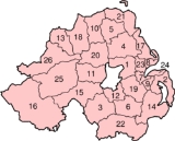
Districts
|
|
History
The current pattern of local government in Northern Ireland, with 26 councils, was established in 1973 by the Local Government (Boundaries) Act (Northern Ireland) 1971Local Government (Boundaries) Act (Northern Ireland) 1971
The Local Government Act 1971 was an Act of the Parliament of Northern Ireland, passed in 1971 to replace the previous system of local authorities established by the Local Government Act 1898...
and the Local Government Act (Northern Ireland) 1972
Local Government Act (Northern Ireland) 1972
The Local Government Act 1972 was an Act of the Parliament of Northern Ireland that constituted district councils to administer the twenty-six local government districts created by the Local Government Act 1971, and abolished the existing local authorities in Northern Ireland.-District...
to replace the previous system established by the Local Government (Ireland) Act 1898
Local Government (Ireland) Act 1898
The Local Government Act 1898 was an Act of the Parliament of the United Kingdom that established a system of local government in Ireland similar to that already created for England, Wales and Scotland by legislation in 1888 and 1889...
. The system is based on the recommendations of the Macrory Report, of June 1970, which presupposed the continued existence of the Government of Northern Ireland
Executive Committee of the Privy Council of Northern Ireland
The Executive Committee or the Executive Committee of the Privy Council of Northern Ireland was the government of Northern Ireland created under the Government of Ireland Act 1920. Generally known as either the Cabinet or the Government, the Executive Committee existed from 1922 to 1972...
to act as a regional-level authority.
From 1921 to 1973, Northern Ireland was divided into six administrative counties
Counties of Northern Ireland
The counties of Northern Ireland were the principal local government divisions of Northern Ireland from its creation in 1921 until 1972 when their governmental features were abolished and replaced with twenty-six unitary authorities....
(subdivided into urban and rural districts) and two county borough
County borough
County borough is a term introduced in 1889 in the United Kingdom of Great Britain and Ireland , to refer to a borough or a city independent of county council control. They were abolished by the Local Government Act 1972 in England and Wales, but continue in use for lieutenancy and shrievalty in...
s. The counties and county boroughs continue to exist for the purposes of lieutenancy and shrievalty.
Elections
Councillors are elected for a four-year term of office under the single transferable voteSingle transferable vote
The single transferable vote is a voting system designed to achieve proportional representation through preferential voting. Under STV, an elector's vote is initially allocated to his or her most preferred candidate, and then, after candidates have been either elected or eliminated, any surplus or...
(STV) system. Elections were last held in May 2005. The elections due in 2009 were postponed in anticipation of local government reform. With the abandonment of the reorganisation, the elections were held in May 2011, with the next polls due in May 2015. In order to qualify for election, a councillor candidate must be:
- at least 18 years of age, and
- a British, Irish, CommonwealthCommonwealth of NationsThe Commonwealth of Nations, normally referred to as the Commonwealth and formerly known as the British Commonwealth, is an intergovernmental organisation of fifty-four independent member states...
or European UnionEuropean UnionThe European Union is an economic and political union of 27 independent member states which are located primarily in Europe. The EU traces its origins from the European Coal and Steel Community and the European Economic Community , formed by six countries in 1958...
citizen.
In addition, he or she must either:
- be a local elector for the district, or
- have, during the whole of the 12-month period prior to the election, either owned or occupied land in the district, or else resided or worked in the district.
For local government purposes, Northern Ireland was previously divided into six administrative counties
Counties of Ireland
The counties of Ireland are sub-national divisions used for the purposes of geographic demarcation and local government. Closely related to the county is the County corporate which covered towns or cities which were deemed to be important enough to be independent from their counties. A county...
and two county borough
County borough
County borough is a term introduced in 1889 in the United Kingdom of Great Britain and Ireland , to refer to a borough or a city independent of county council control. They were abolished by the Local Government Act 1972 in England and Wales, but continue in use for lieutenancy and shrievalty in...
s, with various rural district
Rural district
Rural districts were a type of local government area – now superseded – established at the end of the 19th century in England, Wales, and Ireland for the administration of predominantly rural areas at a level lower than that of the administrative counties.-England and Wales:In England...
s and urban district
Urban district
In the England, Wales and Ireland, an urban district was a type of local government district that covered an urbanised area. Urban districts had an elected Urban District Council , which shared local government responsibilities with a county council....
s in the counties. This system, with the abolition of rural districts, remains the model for local government in the Republic of Ireland
Republic of Ireland
Ireland , described as the Republic of Ireland , is a sovereign state in Europe occupying approximately five-sixths of the island of the same name. Its capital is Dublin. Ireland, which had a population of 4.58 million in 2011, is a constitutional republic governed as a parliamentary democracy,...
. See: List of rural and urban districts in Northern Ireland for more details.
Education and libraries
There are currently five education and library boards (ELBs) in Northern Ireland.As part of the Review of Public Administration process, the library functions of the ELBs were taken over by a new body, the Northern Ireland Library Authority (branded Libraries NI) in April 2009.
The education and skills functions were to have been centralised into a single Education and Skills Authority in January 2010, but this has been postponed.
The boards are as follows:
| Name | Area | ||
|---|---|---|---|
| 1. | Belfast |  |
|
| 2. | North Eastern | Antrim, Ballymena, Ballymoney, Carrickfergus, Coleraine, Larne, Magherafelt, Moyle, Newtownabbey | |
| 3. | South Eastern | Ards, Castlereagh, Down, Lisburn and North Down | |
| 4. | Southern | Armagh, Banbridge, Cookstown, Craigavon, Dungannon and South Tyrone, Newry and Mourne | |
| 5. | Western | Derry, Fermanagh, Limavady, Omagh, Strabane |
Health and social care
There were four health and social services boards which were replaced by a single Health and Social Care Board in April 2009.The former health and social services boards were as follows:
| Name | Area | ||
|---|---|---|---|
| 1. | Eastern | Ards, Belfast, Castlereagh, Down, Lisburn, North Down | 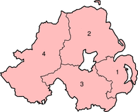 |
| 2. | Northern | Antrim, Ballymena, Ballymoney, Carrickfergus, Coleraine, Cookstown, Larne, Magherafelt, Moyle, Newtownabbey | |
| 3. | Southern | Armagh, Banbridge, Craigavon, Dungannon and South Tyrone, Newry and Mourne | |
| 4. | Western | Derry, Fermanagh, Limavady, Omagh, Strabane |
Eurostat NUTS level 3
In the EurostatEurostat
Eurostat is a Directorate-General of the European Commission located in Luxembourg. Its main responsibilities are to provide the European Union with statistical information at European level and to promote the integration of statistical methods across the Member States of the European Union,...
Nomenclature of Territorial Units for Statistics
Nomenclature of Territorial Units for Statistics
The Nomenclature of Territorial Units for Statistics or Nomenclature of Units for Territorial Statistics is a geocode standard for referencing the subdivisions of countries for statistical purposes...
(NUTS), Northern Ireland is divided into five parts at level 3
| Name | Area | ||
|---|---|---|---|
| 1. | Belfast |  |
|
| 2. | Outer Belfast | Carrickfergus, Castlereagh, Lisburn, Newtownabbey, North Down | |
| 3. | East | Antrim, Ards, Ballymena, Banbridge, Craigavon, Down, Larne | |
| 4. | North | Ballymoney, Coleraine, Derry, Limavady, Moyle, Strabane | |
| 5. | West and South | Armagh, Cookstown, Dungannon, Fermanagh, Magherafelt, Newry and Mourne, Omagh |
Proposed reform
In June 2002 the Northern Ireland ExecutiveNorthern Ireland Executive
The Northern Ireland Executive is the executive arm of the Northern Ireland Assembly, the devolved legislature for Northern Ireland. It is answerable to the Assembly and was established according to the terms of the Northern Ireland Act 1998, which followed the Good Friday Agreement...
established a Review of Public Administration to review the arrangements for the accountability, development, administration and delivery of public services. Among its recommendations were a reduction in the number of districts. In 2005 Peter Hain
Peter Hain
Peter Gerald Hain is a British Labour Party politician, who has been the Member of Parliament for the Welsh constituency of Neath since 1991, and has served in the Cabinets of both Tony Blair and Gordon Brown, firstly as Leader of the House of Commons under Blair and both Secretary of State for...
, the Secretary of State for Northern Ireland
Secretary of State for Northern Ireland
The Secretary of State for Northern Ireland, informally the Northern Ireland Secretary, is the principal secretary of state in the government of the United Kingdom with responsibilities for Northern Ireland. The Secretary of State is a Minister of the Crown who is accountable to the Parliament of...
, announced proposals to reduce the number of councils to seven. The names and boundaries of the seven districts were announced in March 2007. In March 2008 the restored Northern Executive agreed to create eleven new councils instead of the original seven. The first elections were due to take place in May 2011. However by May 2010 disagreements among parties in the executive over district boundaries were expected to delay the reforms until 2015. In June 2010 the proposed reforms were abandoned following the failure of the Northern Ireland Executive to reach agreement.
See also
- List of districts in Northern Ireland by area
- List of districts in Northern Ireland by population
- List of districts in Northern Ireland by population density
- List of districts in Northern Ireland by community make-up
- ISO 3166-2:GBISO 3166-2:GBISO 3166-2:GB is the entry for the United Kingdom in ISO 3166-2, part of the ISO 3166 standard published by the International Organization for Standardization , which defines codes for the names of the principal subdivisions of all countries coded in ISO 3166-1.Currently for the United Kingdom,...
, subdivision codes for the United Kingdom - Local government in England
- Local government in Scotland
- Local government in Wales
- Local government in the Republic of IrelandLocal government in the Republic of IrelandLocal government functions in the Republic of Ireland are mostly exercised by thirty-four local authorities, termed county or city councils, which cover the entire territory of the state. The area under the jurisdiction of each of these authorities corresponds to the area of each of the 34 LAU I...
- Political make-up of local councils in Northern Ireland
External links
- NI Direct - Local Council Websites
- NI Local Government Association
- Review of Public Administration NI
- Local Government Boundaries Commissioner for Northern Ireland
- DOENI - Local Government
- Macrory Report
- Local Government (Boundaries) Act (Northern Ireland) 1971
- Northern Ireland Councillor's Handbook