
Lough Neagh
Encyclopedia
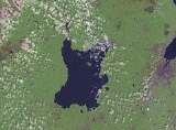
Lough Neagh, sometimes Loch Neagh, (ˌlɒx ˈneɪ) is a large freshwater
lake
in Northern Ireland
. Its name comes (ɫ̪ɔx ˈn̠ʲahax).
and ranks among the forty largest lakes of Europe. Located twenty miles (30 km) to the west of Belfast
, it is approximately twenty miles (30 km) long and nine miles (15 km) wide. It is very shallow around the margins and the average depth in the main body of the lake is about 9 m (30 ft); although at its deepest the lough is about 25 metres (80 ft) deep.
. As one of its sources is the Upper Bann, the Lough can itself be considered a part of the Bann.
, Antrim
, Crumlin
, Randalstown
, Toomebridge, Ballyronan
, Ballinderry
, Moortown
, Ardboe
, Maghery
, Lurgan
and Magherafelt
.
have shores on the Lough (only Fermanagh
does not), and its area is split among them. The counties are listed clockwise:
of Northern Irelands, which are listed clockwise:
works at Hog Park Point, have long been planned but are yet to materialise.
 Traditional working boats on Lough Neagh include wide-beamed 16 to 21 ft (4.9 to 6.4 m) clinker-built, sprit-rigged working boats and smaller flat-bottomed "cots" and "flats". Barges, here called "lighters", were used up to the 1940s to transport coal over the lough and adjacent canals. Up to the 17th century, log boats (coití) were the main means of transport, some of which are as old as 6,400 years. Few traditional boats are left now, but a community-based group on the southern shore of the lough is rebuilding a series of working boats.
In the 19th century, three canal
s were constructed, making use of the lough to link various ports and cities: the Lagan Navigation provided a link from the city of Belfast
, the Newry Canal
linked to the port of Newry
, and the Ulster Canal
led to the Lough Erne
navigations, providing a navigable inland route via the River Shannon
to Limerick
, Dublin and Waterford
. The Lower Bann was also navigable to Coleraine
and the Antrim coast, and the short Coalisland Canal
provided a route for coal transportation. Of these waterways, only the Lower Bann remains open today, however a restoration plan for the Ulster Canal is currently in progress.
Lough Neagh Rescue
provides a Search & Rescue service twenty-four hours a day. It is a voluntary service with funding being provided by the District Councils bordering the Lough, its members are highly trained and are a declared facility for the Marine Coastguard Agency who co-ordinate rescues on Lough Neagh Maritime and Coastguard Agency
.
Lough Neagh attracts bird watchers from many nations due to the number and variety of birds which winter and summer in the boglands and shores around the lough.
Eel
fishing
has been a major industry in Lough Neagh for centuries. Today Lough Neagh eel fisheries export their eels to restaurants all over the world.
Lough Neagh was widely assumed to be owned by the state, but in 2005 it publicly emerged that it is the ancestral property of the Earl of Shaftesbury
. This may have serious implications for planned changes to state-run domestic water services in Northern Ireland, as the lough supplies 40% of the region's drinking water
and is also used as a sewage
outfall (in a system only permissible through British Crown immunity).
(Finn McCool) scooped up a portion of the land and tossed it at a Scottish
rival. He missed, and the chunk of earth landed in the Irish Sea
, thus creating the Isle of Man
.
Freshwater
Fresh water is naturally occurring water on the Earth's surface in ice sheets, ice caps, glaciers, bogs, ponds, lakes, rivers and streams, and underground as groundwater in aquifers and underground streams. Fresh water is generally characterized by having low concentrations of dissolved salts and...
lake
Lake
A lake is a body of relatively still fresh or salt water of considerable size, localized in a basin, that is surrounded by land. Lakes are inland and not part of the ocean and therefore are distinct from lagoons, and are larger and deeper than ponds. Lakes can be contrasted with rivers or streams,...
in Northern Ireland
Northern Ireland
Northern Ireland is one of the four countries of the United Kingdom. Situated in the north-east of the island of Ireland, it shares a border with the Republic of Ireland to the south and west...
. Its name comes (ɫ̪ɔx ˈn̠ʲahax).
Geography
With an area of 392 square kilometres (151.4 sq mi), it is the largest lake in the British IslesBritish Isles
The British Isles are a group of islands off the northwest coast of continental Europe that include the islands of Great Britain and Ireland and over six thousand smaller isles. There are two sovereign states located on the islands: the United Kingdom of Great Britain and Northern Ireland and...
and ranks among the forty largest lakes of Europe. Located twenty miles (30 km) to the west of Belfast
Belfast
Belfast is the capital of and largest city in Northern Ireland. By population, it is the 14th biggest city in the United Kingdom and second biggest on the island of Ireland . It is the seat of the devolved government and legislative Northern Ireland Assembly...
, it is approximately twenty miles (30 km) long and nine miles (15 km) wide. It is very shallow around the margins and the average depth in the main body of the lake is about 9 m (30 ft); although at its deepest the lough is about 25 metres (80 ft) deep.
Islands
- Coney IslandConey Island, Lough NeaghConey Island is an island in Lough Neagh, Northern Ireland. It is situated approximately 1 km from Maghery in County Armagh, is thickly wooded and of nearly in area. It lies between the mouths of the River Blackwater and the River Bann in the south-west corner of Lough Neagh. Boat trips to the...
- Coney Island Flat
- Croaghan Flat
- Derrywarragh IslandDerrywarragh IslandDerrywarragh Island is a boulder clay island on Lough Neagh, Northern Ireland. It is linked by a bridge to Maghery, County Armagh. The island is approximately northwest of Portadown. Most of the island is wet grassland. There are also areas of wet woodland, marshes and swamps...
- Padian
- Ram's Island
- Phil Roe's Flat
- The Shallow Flat
Hydrology
Of the 4550 km² catchment area, around 9% lies in the Republic of Ireland and 91% in Northern Ireland; altogether 43% of the land area of Northern Ireland is drained into the lough, which itself flows out northwards to the sea via the River BannRiver Bann
The River Bann is the longest river in Northern Ireland, the total length being 80 miles . The river winds its way from the south east corner of Northern Ireland to the north west coast, pausing in the middle to widen into the enormous Lough Neagh...
. As one of its sources is the Upper Bann, the Lough can itself be considered a part of the Bann.
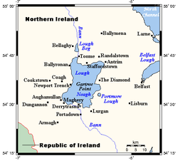
Towns and villages
Towns and villages near the Lough include CraigavonCraigavon
Craigavon is a settlement in north County Armagh, Northern Ireland. It was a planned settlement that was begun in 1965 and named after Northern Ireland's first Prime Minister — James Craig, 1st Viscount Craigavon. It was intended to be a linear city incorporating Lurgan and Portadown, but this plan...
, Antrim
Antrim, County Antrim
Antrim is a town in County Antrim in the northeast of Northern Ireland, on the banks of the Six Mile Water, half a mile north-east of Lough Neagh. It had a population of 20,001 people in the 2001 Census. The town is the administrative centre of Antrim Borough Council...
, Crumlin
Crumlin, County Antrim
Crumlin is a village in County Antrim, Northern Ireland. It is at the head of a wooded glen on the Camlin River, near Lough Neagh, and west of Belfast city centre. It had a population of over 4,259 people in the 2001 Census...
, Randalstown
Randalstown
Randalstown is a small town in County Antrim, Northern Ireland, located between the towns of Antrim and Toome. It had a population of 4,956 people in the 2001 Census. It has a very prominent disused railway viaduct and lies beside Lough Neagh and the Shane's Castle estate...
, Toomebridge, Ballyronan
Ballyronan
Ballyronan is a village and townland in County Londonderry, Northern Ireland, on the shores of Lough Neagh. The village is from Magherafelt and from Cookstown, and is within the Cookstown District close to its border with Magherafelt District.-History:...
, Ballinderry
Ballinderry
Ballinderry is a small civil and ecclesiastical parish on both sides of the County Londonderry / County Tyrone border in Northern Ireland. It is a rural parish of about 350 houses and lies on the western shores of Lough Neagh....
, Moortown
Moortown, County Tyrone
Moortown is a rural area in the north east of County Tyrone, Northern Ireland. It lies on the western shores of Lough Neagh, beside Ballinderry and Ardboe. It is relatively close to the towns of Cookstown, Magherafelt and Dungannon. It is in Cookstown District Council area...
, Ardboe
Ardboe
Ardboe is a small village in the north east of County Tyrone, Northern Ireland. It is near the western shore of Lough Neagh and lies within the Cookstown District Council area...
, Maghery
Maghery
Maghery is a small village and townland in County Armagh, Northern Ireland. It lies on the southwest shore of Lough Neagh, near Derrywarragh Island, in the northwest corner of the county...
, Lurgan
Lurgan
Lurgan is a town in County Armagh, Northern Ireland. The town is near the southern shore of Lough Neagh and in the north-eastern corner of the county. Part of the Craigavon Borough Council area, Lurgan is about 18 miles south-west of Belfast and is linked to the city by both the M1 motorway...
and Magherafelt
Magherafelt
Magherafelt is a small town in County Londonderry, Northern Ireland. It had a population of 8,372 people recorded in the 2001 Census. It is the biggest town in the south of County Londonderry and is the social, economic and political hub of the area...
.
Administration
Counties
Five of the six counties of Northern IrelandCounties of Northern Ireland
The counties of Northern Ireland were the principal local government divisions of Northern Ireland from its creation in 1921 until 1972 when their governmental features were abolished and replaced with twenty-six unitary authorities....
have shores on the Lough (only Fermanagh
County Fermanagh
Fermanagh District Council is the only one of the 26 district councils in Northern Ireland that contains all of the county it is named after. The district council also contains a small section of County Tyrone in the Dromore and Kilskeery road areas....
does not), and its area is split among them. The counties are listed clockwise:
- AntrimCounty AntrimCounty Antrim is one of six counties that form Northern Ireland, situated in the north-east of the island of Ireland. Adjoined to the north-east shore of Lough Neagh, the county covers an area of 2,844 km², with a population of approximately 616,000...
(eastern half of the lake) - DownCounty Down-Cities:*Belfast *Newry -Large towns:*Dundonald*Newtownards*Bangor-Medium towns:...
(small part in the southeast) - ArmaghCounty Armagh-History:Ancient Armagh was the territory of the Ulaid before the fourth century AD. It was ruled by the Red Branch, whose capital was Emain Macha near Armagh. The site, and subsequently the city, were named after the goddess Macha...
(south) - TyroneCounty TyroneHistorically Tyrone stretched as far north as Lough Foyle, and comprised part of modern day County Londonderry east of the River Foyle. The majority of County Londonderry was carved out of Tyrone between 1610-1620 when that land went to the Guilds of London to set up profit making schemes based on...
(west) - LondonderryCounty LondonderryThe place name Derry is an anglicisation of the old Irish Daire meaning oak-grove or oak-wood. As with the city, its name is subject to the Derry/Londonderry name dispute, with the form Derry preferred by nationalists and Londonderry preferred by unionists...
(extreme northwest)
Local Government Districts
The area of the lake is split between six Local Government DistrictsLocal government in Northern Ireland
Northern Ireland is divided into 26 districts for local government purposes. In Northern Ireland local councils do not carry out the same range of functions as those in the rest of the United Kingdom, for example they have no responsibility for education, for road building or for housing...
of Northern Irelands, which are listed clockwise:
- 1 Antrim, in the northeast, with the largest share
- 19 Lisburn CityLisburn City CouncilLisburn City Council is a district council covering an area partly in County Antrim and partly in County Down in Northern Ireland. The council is the second largest in the Belfast Metropolitan Area. Council headquarters are in the city of Lisburn, upon which was conferred city status in May 2002 as...
, in the east, with the smallest share - 12 CraivagonCraigavon Borough CouncilCraigavon Borough Council is a local council in counties Armagh, Down and Antrim, in Northern Ireland. The headquarters of the council is in Craigavon, on the shores of Lough Neagh, a new town built between Lurgan and Portadown. The council area includes the large towns of Lurgan and Portadown, as...
, in the south, with a larger share - 15 Dungannon and South TyroneDungannon and South Tyrone Borough CouncilDungannon and South Tyrone Borough Council is a local council in Northern Ireland. Its main town is Dungannon, where the council is headquartered. The council area covers the southern part of County Tyrone and has a population of nearly 48,000...
, in the southwest, with a smaller share - 11 CookstownCookstown District CouncilCookstown District Council is a district council covering an area largely in County Tyrone and partly in County Londonderry. Council headquarters are in Cookstown. Small towns in the council area include Pomeroy, Moneymore, Coagh and Stewartstown and in the east the area is bounded by Lough Neagh...
, in the west, with a larger share - 20 MagherafeltMagherafelt District CouncilMagherafelt District Council is a district council in County Londonderry in Northern Ireland. Council headquarters are in Magherafelt. The Council area stretches from Lough Neagh and the River Bann in the east and into the Sperrin Mountains in the west and is divided by the Moyola River. It covers...
, in the northwest, with a smaller share
Uses
Although the Lough is used for a variety of recreational and commercial activities, it is exposed and tends to get extremely rough very quickly in windy conditions. It is also used as a source of fresh water by Northern Ireland Water. Plans to increase the amount of water drawn from the Lough, through a new water treatmentWater treatment
Water treatment describes those processes used to make water more acceptable for a desired end-use. These can include use as drinking water, industrial processes, medical and many other uses. The goal of all water treatment process is to remove existing contaminants in the water, or reduce the...
works at Hog Park Point, have long been planned but are yet to materialise.
In the 19th century, three canal
Canal
Canals are man-made channels for water. There are two types of canal:#Waterways: navigable transportation canals used for carrying ships and boats shipping goods and conveying people, further subdivided into two kinds:...
s were constructed, making use of the lough to link various ports and cities: the Lagan Navigation provided a link from the city of Belfast
Belfast
Belfast is the capital of and largest city in Northern Ireland. By population, it is the 14th biggest city in the United Kingdom and second biggest on the island of Ireland . It is the seat of the devolved government and legislative Northern Ireland Assembly...
, the Newry Canal
Newry Canal
The Newry Canal, located in Northern Ireland, was built to link the Tyrone coalfields to the Irish Sea at Carlingford Lough near Newry.-History:...
linked to the port of Newry
Newry
Newry is a city in Northern Ireland. The River Clanrye, which runs through the city, formed the historic border between County Armagh and County Down. It is from Belfast and from Dublin. Newry had a population of 27,433 at the 2001 Census, while Newry and Mourne Council Area had a population...
, and the Ulster Canal
Ulster Canal
The Ulster Canal is a disused canal running through part of County Armagh, County Tyrone and County Fermanagh in Northern Ireland and County Monaghan in the Republic of Ireland...
led to the Lough Erne
Lough Erne
Lough Erne, sometimes Loch Erne , is the name of two connected lakes in County Fermanagh, Northern Ireland. The lakes are widened sections of the River Erne. The river begins by flowing north, and then curves west into the Atlantic. The southern lake is further up the river and so is named Upper...
navigations, providing a navigable inland route via the River Shannon
River Shannon
The River Shannon is the longest river in Ireland at . It divides the west of Ireland from the east and south . County Clare, being west of the Shannon but part of the province of Munster, is the major exception...
to Limerick
Limerick
Limerick is the third largest city in the Republic of Ireland, and the principal city of County Limerick and Ireland's Mid-West Region. It is the fifth most populous city in all of Ireland. When taking the extra-municipal suburbs into account, Limerick is the third largest conurbation in the...
, Dublin and Waterford
Waterford
Waterford is a city in the South-East Region of Ireland. It is the oldest city in the country and fifth largest by population. Waterford City Council is the local government authority for the city and its immediate hinterland...
. The Lower Bann was also navigable to Coleraine
Coleraine
Coleraine is a large town near the mouth of the River Bann in County Londonderry, Northern Ireland. It is northwest of Belfast and east of Derry, both of which are linked by major roads and railway connections...
and the Antrim coast, and the short Coalisland Canal
Coalisland Canal
Coalisland Canal is a canal in County Tyrone, Northern Ireland and is about long. Construction of the canal began in 1733, but progress was slow and it was not officially opened until 1787. The canal was built to reduce the cost of transporting coal from the Tyrone coalfields to Dublin...
provided a route for coal transportation. Of these waterways, only the Lower Bann remains open today, however a restoration plan for the Ulster Canal is currently in progress.
Lough Neagh Rescue
Lough Neagh Rescue
Lough Neagh Rescue is a Lifeboat service based on Lough Neagh in Northern Ireland. Lough Neagh Rescue provides a rescue service 24 hours a day, it is a voluntary service, but its members are dedicated and possess significant expertise...
provides a Search & Rescue service twenty-four hours a day. It is a voluntary service with funding being provided by the District Councils bordering the Lough, its members are highly trained and are a declared facility for the Marine Coastguard Agency who co-ordinate rescues on Lough Neagh Maritime and Coastguard Agency
Maritime and Coastguard Agency
The Maritime and Coastguard Agency is a UK executive agency working to prevent the loss of lives at sea and is responsible for implementing British and International maritime law and safety policy.This involves coordinating search and rescue at sea through Her Majesty's Coastguard , ensuring that...
.
Lough Neagh attracts bird watchers from many nations due to the number and variety of birds which winter and summer in the boglands and shores around the lough.
Eel
Eel
Eels are an order of fish, which consists of four suborders, 20 families, 111 genera and approximately 800 species. Most eels are predators...
fishing
Fishing
Fishing is the activity of trying to catch wild fish. Fish are normally caught in the wild. Techniques for catching fish include hand gathering, spearing, netting, angling and trapping....
has been a major industry in Lough Neagh for centuries. Today Lough Neagh eel fisheries export their eels to restaurants all over the world.
Lough Neagh was widely assumed to be owned by the state, but in 2005 it publicly emerged that it is the ancestral property of the Earl of Shaftesbury
Earl of Shaftesbury
Earl of Shaftesbury is a title in the Peerage of England. It was created in 1672 for Anthony Ashley-Cooper, 1st Baron Ashley, a prominent politician in the Cabal then dominating the policies of King Charles II...
. This may have serious implications for planned changes to state-run domestic water services in Northern Ireland, as the lough supplies 40% of the region's drinking water
Drinking water
Drinking water or potable water is water pure enough to be consumed or used with low risk of immediate or long term harm. In most developed countries, the water supplied to households, commerce and industry is all of drinking water standard, even though only a very small proportion is actually...
and is also used as a sewage
Sewage
Sewage is water-carried waste, in solution or suspension, that is intended to be removed from a community. Also known as wastewater, it is more than 99% water and is characterized by volume or rate of flow, physical condition, chemical constituents and the bacteriological organisms that it contains...
outfall (in a system only permissible through British Crown immunity).
Legend
An old Irish story tells how the Lough was formed when Ireland's legendary giant Fionn mac CumhaillFionn mac Cumhaill
Fionn mac Cumhaill , known in English as Finn McCool, was a mythical hunter-warrior of Irish mythology, occurring also in the mythologies of Scotland and the Isle of Man...
(Finn McCool) scooped up a portion of the land and tossed it at a Scottish
Scotland
Scotland is a country that is part of the United Kingdom. Occupying the northern third of the island of Great Britain, it shares a border with England to the south and is bounded by the North Sea to the east, the Atlantic Ocean to the north and west, and the North Channel and Irish Sea to the...
rival. He missed, and the chunk of earth landed in the Irish Sea
Irish Sea
The Irish Sea separates the islands of Ireland and Great Britain. It is connected to the Celtic Sea in the south by St George's Channel, and to the Atlantic Ocean in the north by the North Channel. Anglesey is the largest island within the Irish Sea, followed by the Isle of Man...
, thus creating the Isle of Man
Isle of Man
The Isle of Man , otherwise known simply as Mann , is a self-governing British Crown Dependency, located in the Irish Sea between the islands of Great Britain and Ireland, within the British Isles. The head of state is Queen Elizabeth II, who holds the title of Lord of Mann. The Lord of Mann is...
.
See also
- List of loughs in Ireland
- Lough BegLough BegLough Beg is a small freshwater lake north of Lough Neagh in Northern Ireland. The lake is located on the border between County Londonderry and County Antrim....
- Portmore LoughPortmore LoughPortmore Lough is a small lake in southwest County Antrim, Northern Ireland that drains water into nearby Lough Neagh. It is roughly circular and covers an area of 286 hectares...
- Traad PointTraadTraad , also known as Traad Point, is a small peninsula near Ballyronan in County Londonderry, Northern Ireland. Located at the north-west of Lough Neagh, it has a large conservation area that is abundant with wildlife as well as a nine-hole golf club....