

Cornovii
Encyclopedia
The Cornovii were a Celtic people of Iron Age
and Roman Britain
, who lived principally in the modern English counties of Cheshire
, Shropshire
, north Staffordshire
, north Herefordshire
and eastern parts of the Welsh county of Powys
. Their capital in pre-Roman times was probably a hill fort
on The Wrekin
. Ptolemy
's 2nd century Geography names two of their towns: Deva Victrix
(Chester
), and Viroconium Cornoviorum (Wroxeter
), which became their capital under Roman
rule.
Their territory was bordered by the Brigantes
to the North, the Corieltauvi to the East, the Dobunni
to the South, and the Deceangli
, and Ordovices
to the West.
The people who inhabited the very north of the British mainland (modern Caithness
), and Cornwall
were also known by the same name, but according to mainstream or academic opinion were quite separate and unrelated peoples. (see List of Celtic tribes).
in the 2nd century A.D.:
The name itself may mean "People of the Horn". Graham Webster in The Cornovii (1991) cites Anne Ross's hypothesis that the tribal name(s) may be totemic cult-names referring to a "horned god
" cult followed by the tribe(s). There is no direct evidence of this; however, Webster points out that it is interesting that at Abbot's Bromley the "horn dance" has survived from pagan ritual—Abbot's Bromley being only 55 km north east of the old tribal centre at Wroxeter
(Virconium Cornoviorum). In addition, Webster quotes Professor Charles Thomas
as having made a "good case" for such totemic ethnonyms in Scotland
.
s and metalwork artifacts. The Cornovi built numerous hill forts, including Titterstone Clee near Bitterley
. Old Oswestry
hill fort is also thought to have been inhabited by the Cornovii. One of these hill forts is probably that referred to by the historian Tacitus
as the last refuge of the resistance led by Caratacus
in 50 AD. However, the nature of hill forts is strongly contested among archaeologists, with some crediting them only as tribal status symbols or cattle stockades rather than defended settlements.
The tribe developed no known coinage, but their control of the south-Cheshire salt-making industry and parts of its distribution network probably gave them a fair degree of wealth, multiplied by trading and cattle breeding. However, their economy was mainly a pastoral one. Since the early Iron Age they had had a network of paved and semi-paved roads good enough to transport their famous chariots.
It should not be assumed that the Cornovii looked like paint-daubed savages; the Romans, who described the British as "vain", noted their attention to appearance and personal hygiene. Gold and bronze torc
s (i.e.: heavy necklaces made of twisted strands of metal) have been found at Iron Age sites in the region. They were expert in weaving and dyeing, and loved bright colours. Women wore their hair in two thick thigh-length plaits.
in Yorkshire
outside of known Cornovii territory.
This is the only epigraphic evidence of civilian occupation at Ilkley (Roman Verbeia
). Vedica may possibly have been the daughter of a chieftain "Viroco" of the Cornovii, who was killed during the western expansion of early 47 AD commanded by Publius Ostorius Scapula
.
, being the only one excavated to date, Chesterton Walls near Romsley
and Bury Walls near Weston-under-Redcastle
. Other hillforts of Iron Age
Cornovii include the Wrekin hillfort near Wellington
, Caynham Camp near Poughnhill and Old Oswestry
. All of these camps are in the county of Shropshire
but there was another significant settlement at the Breiddin hillfort in Powys
.
Some suggest that a lack of metal and fine pottery finds may be indicative that the Cornovii were not a particularly wealthy or sophisticated British tribe and that they depended mostly on a pastoral economy even though some cultivation of cereal crops appears to have occurred in the river valley areas. These aforeseaid lowland areas seem to have been populated by rural peasants who were obliged to pay tribute in cattle and grain to the local chieftains resident in the hillforts.
 The tribal civitas
capital was Viroconium Cornoviorum (or simply "Viroconium"), the fourth largest town in Roman Britain. It started life as a legionary fortress in the mid-1st century, possibly garrisoned by the XIV Legion then the XX Legion. The main section of Watling Street
runs from Dubrium (Dover) to Viroconium (Wroxeter). The place-name itself is suggestive of the Wrekin hillfort, overlooking the site from the east. The Cornovii seem to have had many hillforts, the largest and most populous being that at the Wrekin near the site of the Romano-British
tribal capital.
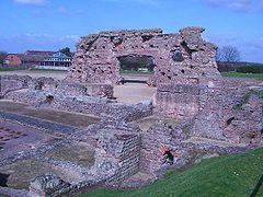
The eventual size of Viroconium is inconsistent with the estimated population size, taken from the number of known pre-Roman settlements in the area; the archaeological evidence suggests a sparsely populated region. Perhaps the majority of the population lived in timber hut-dwellings without stone foundations, making it more difficult to find archaeological trace. There are, however, impressive standing Roman ruins from Viroconium just outside the modern day village of Wroxeter.
By the time the city had become fully established as a civitas
capital, Viroconium had seen great expansion, with all the usual trappings of a classical Roman settlement including the forum basilica
, shops and, of course, the baths. Both the massive structural remains of the baths and exercise yard found during archaeological excavations and subsequent research indicate that Viroconium's most prosperous era was between the 2nd and 3rd centuries, and demonstrate the success of this regional economic centre. Nevertheless it appears that by the 4th century the area was already starting to decline.
Viroconium Cornoviorum and Calleva Atrebatum (Silchester
) seem to be the only major Roman settlements in Britain that, subsequently, did not grow into larger towns or cities in the post-Roman period. This may have been due to the foundation of Shrewsbury
(probably in the 9th century) nearby, which was more easily defended, although the village of Wroxeter still continued to grow.
Owing to little development in the Wroxeter area, much of the Roman material has survived reasonably intact compared to other parts of Britain. This has led to the town becoming a favourite among archaeologists and students of Roman Britain
.
(Newcastle-upon-Tyne) at the eastern terminus of Hadrian's Wall
. This is recorded in the Notitia Dignitatum
.
was garrisoned for some time. The Romans also exploited metals such as copper, lead and silver in the area. Some Romanised Cornovii are known to have served as Roman legionaries.
The 5th century saw continued town life in Viroconium but many of the buildings fell into disrepair. However, between 530 and 570 there was a substantial rebuilding programme in timber with most of the old basilica being demolished and replaced with new buildings. These probably included a very large two-story timber-framed building and a number of storage buildings and houses. In all, 33 new buildings were constructed. The archaeologists responsible for the most recent excavations comment that "their construction was carefully planned and executed..." and "were skillfully constructed to Roman measurements using a trained labour force". Who instigated this rebuilding program is not known, although it may have been a bishop. Some of the buildings were renewed three times and the community probably lasted about 75 years until for some reason many of the buildings were dismantled.
. Following a period of military alliance with Mercian rulers, particularly King Penda
, Pengwern was absobed by neighbouring Mercia
after 642 AD. The local Cornovian people may have continued to reside in the area, perhaps as the Wrekensaete, under Mercian rule.
The site of the Roman city of Viroconium Cornoviorum is known in Old Welsh as Caer Guricon. As Caer Guricon it may have served as capital of the Kingdom of Powys during the sub-Roman period until Anglo-Saxon
pressures in the form of Mercian encroachment forced the British to relocate to Mathrafal
castle sometime before 717 AD. Pengwern and Powys
themselves may have been later divisions of the pre-Roman Cornovii tribal territory whose civitas was Viroconium Cornoviorum. With the passage of time the lesser Magonsæte sub-kingdom also emerged in this area during the period between Powys and Mercian rule.
's theory deals with the hypothetical link between the Midlands Cornovii and later Cornwall
. In The Age of Arthur, 1973, Morris discussed the Wroxeter dynasty of Constantine
whose name is found, albeit indirectly, in a reference by Gildas
to Constantine as tyrant whelp of the filthy lioness of Dumnonia i.e. the current areas of Devon
, Cornwall
and part of Somerset
. According to this theory, the principal Cornovian families of Viroconium
may have moved to Dumnonia
, sometime around 430 AD.
Morris goes on to mention one Ducco, who is also known as Congar, (d. 473 AD) as a monk on the estate that he had also established there. Morris asserts that the latter name is that which is preserved in the modern name of Congresbury
, Somerset, south of Bristol
. The Cadbury-Congresbury fortification is the only major fortification in Wales
and "Dumnonia" to have produced reasonable evidence for continuous occupation from the 3rd century to the sixth.
. Being the last vicus
on Ermin Street
before the scarp
slope of the Marlborough Downs, Durocornovium was a site where horses were watered before the steep climb off the Oxfordshire plain. It is not obvious why this name was used as it is a long way from the territories of the two Cornovii tribes.
British Iron Age
The British Iron Age is a conventional name used in the archaeology of Great Britain, referring to the prehistoric and protohistoric phases of the Iron-Age culture of the main island and the smaller islands, typically excluding prehistoric Ireland, and which had an independent Iron Age culture of...
and Roman Britain
Roman Britain
Roman Britain was the part of the island of Great Britain controlled by the Roman Empire from AD 43 until ca. AD 410.The Romans referred to the imperial province as Britannia, which eventually comprised all of the island of Great Britain south of the fluid frontier with Caledonia...
, who lived principally in the modern English counties of Cheshire
Cheshire
Cheshire is a ceremonial county in North West England. Cheshire's county town is the city of Chester, although its largest town is Warrington. Other major towns include Widnes, Congleton, Crewe, Ellesmere Port, Runcorn, Macclesfield, Winsford, Northwich, and Wilmslow...
, Shropshire
Shropshire
Shropshire is a county in the West Midlands region of England. For Eurostat purposes, the county is a NUTS 3 region and is one of four counties or unitary districts that comprise the "Shropshire and Staffordshire" NUTS 2 region. It borders Wales to the west...
, north Staffordshire
Staffordshire
Staffordshire is a landlocked county in the West Midlands region of England. For Eurostat purposes, the county is a NUTS 3 region and is one of four counties or unitary districts that comprise the "Shropshire and Staffordshire" NUTS 2 region. Part of the National Forest lies within its borders...
, north Herefordshire
Herefordshire
Herefordshire is a historic and ceremonial county in the West Midlands region of England. For Eurostat purposes it is a NUTS 3 region and is one of three counties that comprise the "Herefordshire, Worcestershire and Gloucestershire" NUTS 2 region. It also forms a unitary district known as the...
and eastern parts of the Welsh county of Powys
Powys
Powys is a local-government county and preserved county in Wales.-Geography:Powys covers the historic counties of Montgomeryshire and Radnorshire, most of Brecknockshire , and a small part of Denbighshire — an area of 5,179 km², making it the largest county in Wales by land area.It is...
. Their capital in pre-Roman times was probably a hill fort
Hill fort
A hill fort is a type of earthworks used as a fortified refuge or defended settlement, located to exploit a rise in elevation for defensive advantage. They are typically European and of the Bronze and Iron Ages. Some were used in the post-Roman period...
on The Wrekin
The Wrekin
The Wrekin is a hill in east Shropshire, England. It is located some west of Telford, on the border between the unitary authorities of Shropshire and Telford and Wrekin. Rising to a height of above the Shropshire Plain, it is a prominent and well-known landmark, marking the entrance to Shropshire...
. Ptolemy
Ptolemy
Claudius Ptolemy , was a Roman citizen of Egypt who wrote in Greek. He was a mathematician, astronomer, geographer, astrologer, and poet of a single epigram in the Greek Anthology. He lived in Egypt under Roman rule, and is believed to have been born in the town of Ptolemais Hermiou in the...
's 2nd century Geography names two of their towns: Deva Victrix
Deva Victrix
Deva Victrix, or simply Deva, was a legionary fortress and town in the Roman province of Britannia. The settlement evolved into Chester, the county town of Cheshire, England...
(Chester
Chester
Chester is a city in Cheshire, England. Lying on the River Dee, close to the border with Wales, it is home to 77,040 inhabitants, and is the largest and most populous settlement of the wider unitary authority area of Cheshire West and Chester, which had a population of 328,100 according to the...
), and Viroconium Cornoviorum (Wroxeter
Wroxeter
Wroxeter is a village in Shropshire, England. It forms part of the civil parish of Wroxeter and Uppington and is located in the Severn Valley about south-east of Shrewsbury.-History:...
), which became their capital under Roman
Roman Empire
The Roman Empire was the post-Republican period of the ancient Roman civilization, characterised by an autocratic form of government and large territorial holdings in Europe and around the Mediterranean....
rule.
Their territory was bordered by the Brigantes
Brigantes
The Brigantes were a Celtic tribe who in pre-Roman times controlled the largest section of what would become Northern England, and a significant part of the Midlands. Their kingdom is sometimes called Brigantia, and it was centred in what was later known as Yorkshire...
to the North, the Corieltauvi to the East, the Dobunni
Dobunni
The Dobunni were one of the Celtic tribes living in the British Isles prior to the Roman invasion of Britain. There are seven known references to the tribe in Roman histories and inscriptions. The latter part of the name possibly derives from Bune, a cup or vessel...
to the South, and the Deceangli
Deceangli
The Deceangli or Deceangi were one of the Celtic tribes living in Britain, prior to the Roman invasion of the island. The tribe lived mainly in what is now north-east Wales, though it is uncertain whether their territory covered only the modern counties of Flintshire, Denbighshire and part of...
, and Ordovices
Ordovices
The Ordovices were one of the Celtic tribes living in Great Britain, before the Roman invasion of Britain. Its tribal lands were located in present day Wales and England between the Silures to the south and the Deceangli to the north-east...
to the West.
The people who inhabited the very north of the British mainland (modern Caithness
Caithness
Caithness is a registration county, lieutenancy area and historic local government area of Scotland. The name was used also for the earldom of Caithness and the Caithness constituency of the Parliament of the United Kingdom . Boundaries are not identical in all contexts, but the Caithness area is...
), and Cornwall
Cornwall
Cornwall is a unitary authority and ceremonial county of England, within the United Kingdom. It is bordered to the north and west by the Celtic Sea, to the south by the English Channel, and to the east by the county of Devon, over the River Tamar. Cornwall has a population of , and covers an area of...
were also known by the same name, but according to mainstream or academic opinion were quite separate and unrelated peoples. (see List of Celtic tribes).
The problem of tribal nomenclature
The first mention of the tribe occurs in the works of PtolemyPtolemy
Claudius Ptolemy , was a Roman citizen of Egypt who wrote in Greek. He was a mathematician, astronomer, geographer, astrologer, and poet of a single epigram in the Greek Anthology. He lived in Egypt under Roman rule, and is believed to have been born in the town of Ptolemais Hermiou in the...
in the 2nd century A.D.:
- "From these¹ toward the east are the Cornavi, among whom are the towns: Deva,² Legio XX Victrix 17*30 56°45, Viroconium³ 16*45 55°45." (Ptolemy Geographia II.ii)
The name itself may mean "People of the Horn". Graham Webster in The Cornovii (1991) cites Anne Ross's hypothesis that the tribal name(s) may be totemic cult-names referring to a "horned god
Horned God
The Horned God is one of the two primary deities found in some European pagan religions. He is often given various names and epithets, and represents the male part of the religion's duotheistic theological system, the other part being the female Triple Goddess. In common Wiccan belief, he is...
" cult followed by the tribe(s). There is no direct evidence of this; however, Webster points out that it is interesting that at Abbot's Bromley the "horn dance" has survived from pagan ritual—Abbot's Bromley being only 55 km north east of the old tribal centre at Wroxeter
Wroxeter
Wroxeter is a village in Shropshire, England. It forms part of the civil parish of Wroxeter and Uppington and is located in the Severn Valley about south-east of Shrewsbury.-History:...
(Virconium Cornoviorum). In addition, Webster quotes Professor Charles Thomas
Charles Thomas (historian)
Antony Charles Thomas, CBE, FSA is a British historian and archaeologist who was Professor of Cornish Studies at Exeter University, and the first Director of the Institute of Cornish Studies, from 1971 until his retirement in 1991...
as having made a "good case" for such totemic ethnonyms in Scotland
Scotland
Scotland is a country that is part of the United Kingdom. Occupying the northern third of the island of Great Britain, it shares a border with England to the south and is bounded by the North Sea to the east, the Atlantic Ocean to the north and west, and the North Channel and Irish Sea to the...
.
Archaeological evidence
The Cornovii produced little in the way of identifiable ceramic wares. Their sites are identified by construction details of their hill fortHill fort
A hill fort is a type of earthworks used as a fortified refuge or defended settlement, located to exploit a rise in elevation for defensive advantage. They are typically European and of the Bronze and Iron Ages. Some were used in the post-Roman period...
s and metalwork artifacts. The Cornovi built numerous hill forts, including Titterstone Clee near Bitterley
Bitterley
Bitterley is a village and civil parish in Shropshire, England. According to the 2001 census it had a population of 802. The village is about four miles east of Ludlow on the western slopes of Titterstone Clee Hill...
. Old Oswestry
Old Oswestry
thumb|250px|right|Old Oswestry hill fortOld Oswestry is a large and impressive early Iron Age hill fort in the Welsh Marches near Oswestry in north west Shropshire....
hill fort is also thought to have been inhabited by the Cornovii. One of these hill forts is probably that referred to by the historian Tacitus
Tacitus
Publius Cornelius Tacitus was a senator and a historian of the Roman Empire. The surviving portions of his two major works—the Annals and the Histories—examine the reigns of the Roman Emperors Tiberius, Claudius, Nero and those who reigned in the Year of the Four Emperors...
as the last refuge of the resistance led by Caratacus
Caratacus
Caratacus was a first century British chieftain of the Catuvellauni tribe, who led the British resistance to the Roman conquest....
in 50 AD. However, the nature of hill forts is strongly contested among archaeologists, with some crediting them only as tribal status symbols or cattle stockades rather than defended settlements.
The tribe developed no known coinage, but their control of the south-Cheshire salt-making industry and parts of its distribution network probably gave them a fair degree of wealth, multiplied by trading and cattle breeding. However, their economy was mainly a pastoral one. Since the early Iron Age they had had a network of paved and semi-paved roads good enough to transport their famous chariots.
It should not be assumed that the Cornovii looked like paint-daubed savages; the Romans, who described the British as "vain", noted their attention to appearance and personal hygiene. Gold and bronze torc
Torc
A torc, also spelled torq or torque, is a large, usually rigid, neck ring typically made from strands of metal twisted together. The great majority are open-ended at the front, although many seem designed for near-permanent wear and would have been difficult to remove. Smaller torcs worn around...
s (i.e.: heavy necklaces made of twisted strands of metal) have been found at Iron Age sites in the region. They were expert in weaving and dyeing, and loved bright colours. Women wore their hair in two thick thigh-length plaits.
The tomb of Vedica, a Cornovian woman
The tombstone of a thirty-year-old woman of the Cornovii called Vedica was found at IlkleyIlkley
Ilkley is a spa town and civil parish in West Yorkshire, in the north of England. Ilkley civil parish includes the adjacent village of Ben Rhydding and is a ward within the metropolitan borough of Bradford. Approximately north of Bradford, the town lies mainly on the south bank of the River Wharfe...
in Yorkshire
Yorkshire
Yorkshire is a historic county of northern England and the largest in the United Kingdom. Because of its great size in comparison to other English counties, functions have been increasingly undertaken over time by its subdivisions, which have also been subject to periodic reform...
outside of known Cornovii territory.
- DIS MANIBVS VEDIC [...] RICONIS FILIA ANNORVM XXX C CORNOVIA H S E
- "To the spirits of the departed and to Vedica,¹ thirty years old, daughter of Virico² of the Cornovii;³ she lies here."
This is the only epigraphic evidence of civilian occupation at Ilkley (Roman Verbeia
Verbeia
In ancient Celtic polytheism, Verbeia was a goddess worshipped in Roman Britain. She is known from a single altar-stone dedicated to her at Ilkley...
). Vedica may possibly have been the daughter of a chieftain "Viroco" of the Cornovii, who was killed during the western expansion of early 47 AD commanded by Publius Ostorius Scapula
Publius Ostorius Scapula
Publius Ostorius Scapula was a Roman statesman and general who governed Britain from 47 until his death, and was responsible for the defeat and capture of Caratacus.-Career:...
.
Pre-Roman history
Prior to the Roman invasion of Cornovian territory in 47 AD the most significant Cornovian hillforts known were those at Titterstone Clee near BitterleyBitterley
Bitterley is a village and civil parish in Shropshire, England. According to the 2001 census it had a population of 802. The village is about four miles east of Ludlow on the western slopes of Titterstone Clee Hill...
, being the only one excavated to date, Chesterton Walls near Romsley
Romsley, Shropshire
Romsley is a civil parish in southeast Shropshire, England. It is bounded on the north and west by Alveley and on the south by Upper Arley in Worcestershire. On its short eastern boundary it meets Compton on Kinver...
and Bury Walls near Weston-under-Redcastle
Weston-under-Redcastle
Weston-under-Redcastle is a small village and civil parish in Shropshire, England.It lies a few miles east of Wem.At one end of the village is the main entrance to Hawkstone Park, hotel and golf courses, and at the other end is a wood....
. Other hillforts of Iron Age
British Iron Age
The British Iron Age is a conventional name used in the archaeology of Great Britain, referring to the prehistoric and protohistoric phases of the Iron-Age culture of the main island and the smaller islands, typically excluding prehistoric Ireland, and which had an independent Iron Age culture of...
Cornovii include the Wrekin hillfort near Wellington
Wellington, Shropshire
Wellington is a town in the unitary authority of Telford and Wrekin and ceremonial county of Shropshire, England and now forms part of the new town of Telford. The population of the parish of Wellington was recorded as 20,430 in the 2001 census, making it the third largest town in Shropshire if...
, Caynham Camp near Poughnhill and Old Oswestry
Old Oswestry
thumb|250px|right|Old Oswestry hill fortOld Oswestry is a large and impressive early Iron Age hill fort in the Welsh Marches near Oswestry in north west Shropshire....
. All of these camps are in the county of Shropshire
Shropshire
Shropshire is a county in the West Midlands region of England. For Eurostat purposes, the county is a NUTS 3 region and is one of four counties or unitary districts that comprise the "Shropshire and Staffordshire" NUTS 2 region. It borders Wales to the west...
but there was another significant settlement at the Breiddin hillfort in Powys
Powys
Powys is a local-government county and preserved county in Wales.-Geography:Powys covers the historic counties of Montgomeryshire and Radnorshire, most of Brecknockshire , and a small part of Denbighshire — an area of 5,179 km², making it the largest county in Wales by land area.It is...
.
Some suggest that a lack of metal and fine pottery finds may be indicative that the Cornovii were not a particularly wealthy or sophisticated British tribe and that they depended mostly on a pastoral economy even though some cultivation of cereal crops appears to have occurred in the river valley areas. These aforeseaid lowland areas seem to have been populated by rural peasants who were obliged to pay tribute in cattle and grain to the local chieftains resident in the hillforts.
Roman period
Civitas
In the history of Rome, the Latin term civitas , according to Cicero in the time of the late Roman Republic, was the social body of the cives, or citizens, united by law . It is the law that binds them together, giving them responsibilities on the one hand and rights of citizenship on the other...
capital was Viroconium Cornoviorum (or simply "Viroconium"), the fourth largest town in Roman Britain. It started life as a legionary fortress in the mid-1st century, possibly garrisoned by the XIV Legion then the XX Legion. The main section of Watling Street
Watling Street
Watling Street is the name given to an ancient trackway in England and Wales that was first used by the Britons mainly between the modern cities of Canterbury and St Albans. The Romans later paved the route, part of which is identified on the Antonine Itinerary as Iter III: "Item a Londinio ad...
runs from Dubrium (Dover) to Viroconium (Wroxeter). The place-name itself is suggestive of the Wrekin hillfort, overlooking the site from the east. The Cornovii seem to have had many hillforts, the largest and most populous being that at the Wrekin near the site of the Romano-British
Romano-British
Romano-British culture describes the culture that arose in Britain under the Roman Empire following the Roman conquest of AD 43 and the creation of the province of Britannia. It arose as a fusion of the imported Roman culture with that of the indigenous Britons, a people of Celtic language and...
tribal capital.
The eventual size of Viroconium is inconsistent with the estimated population size, taken from the number of known pre-Roman settlements in the area; the archaeological evidence suggests a sparsely populated region. Perhaps the majority of the population lived in timber hut-dwellings without stone foundations, making it more difficult to find archaeological trace. There are, however, impressive standing Roman ruins from Viroconium just outside the modern day village of Wroxeter.
By the time the city had become fully established as a civitas
Civitas
In the history of Rome, the Latin term civitas , according to Cicero in the time of the late Roman Republic, was the social body of the cives, or citizens, united by law . It is the law that binds them together, giving them responsibilities on the one hand and rights of citizenship on the other...
capital, Viroconium had seen great expansion, with all the usual trappings of a classical Roman settlement including the forum basilica
Basilica
The Latin word basilica , was originally used to describe a Roman public building, usually located in the forum of a Roman town. Public basilicas began to appear in Hellenistic cities in the 2nd century BC.The term was also applied to buildings used for religious purposes...
, shops and, of course, the baths. Both the massive structural remains of the baths and exercise yard found during archaeological excavations and subsequent research indicate that Viroconium's most prosperous era was between the 2nd and 3rd centuries, and demonstrate the success of this regional economic centre. Nevertheless it appears that by the 4th century the area was already starting to decline.
Viroconium Cornoviorum and Calleva Atrebatum (Silchester
Silchester
Silchester is a village and civil parish about north of Basingstoke in Hampshire. It is adjacent to the county boundary with Berkshire and about south-west of Reading....
) seem to be the only major Roman settlements in Britain that, subsequently, did not grow into larger towns or cities in the post-Roman period. This may have been due to the foundation of Shrewsbury
Shrewsbury
Shrewsbury is the county town of Shropshire, in the West Midlands region of England. Lying on the River Severn, it is a civil parish home to some 70,000 inhabitants, and is the primary settlement and headquarters of Shropshire Council...
(probably in the 9th century) nearby, which was more easily defended, although the village of Wroxeter still continued to grow.
Owing to little development in the Wroxeter area, much of the Roman material has survived reasonably intact compared to other parts of Britain. This has led to the town becoming a favourite among archaeologists and students of Roman Britain
Roman Britain
Roman Britain was the part of the island of Great Britain controlled by the Roman Empire from AD 43 until ca. AD 410.The Romans referred to the imperial province as Britannia, which eventually comprised all of the island of Great Britain south of the fluid frontier with Caledonia...
.
Cohors Primae Cornoviorum
The Cohors Primae Cornoviorum was the only recorded native British unit known to have served in Britannia. The I Cohort of Cornovii were recruited from the tribe itself, thus bearing the name "Cornoviorum", i.e. "of the Cornovii". The strength of this military unit is unknown. The cohort was an infantry unit and is likely to have numbered only 500. The units formed the late 4th century garrison of Pons AeliusPons Aelius
Pons Aelius or Newcastle Roman Fort was an auxiliary castra and small Roman settlement on Hadrian's Wall in the Roman province of Britannia Inferior...
(Newcastle-upon-Tyne) at the eastern terminus of Hadrian's Wall
Hadrian's Wall
Hadrian's Wall was a defensive fortification in Roman Britain. Begun in AD 122, during the rule of emperor Hadrian, it was the first of two fortifications built across Great Britain, the second being the Antonine Wall, lesser known of the two because its physical remains are less evident today.The...
. This is recorded in the Notitia Dignitatum
Notitia Dignitatum
The Notitia Dignitatum is a unique document of the Roman imperial chanceries. One of the very few surviving documents of Roman government, it details the administrative organisation of the eastern and western empires, listing several thousand offices from the imperial court down to the provincial...
.
Posting stations, settlements and military stations
- Bovium (TilstonTilstonTilston is a village and a civil parish in the unitary authority of Cheshire West and Chester and the ceremonial county of Cheshire, England. At the 2001 Census, the population was recorded as 627.St Mary's Church, Tilston is a Grade II* listed building....
, CheshireCheshireCheshire is a ceremonial county in North West England. Cheshire's county town is the city of Chester, although its largest town is Warrington. Other major towns include Widnes, Congleton, Crewe, Ellesmere Port, Runcorn, Macclesfield, Winsford, Northwich, and Wilmslow...
) - Named in the Antonine ItineraryAntonine ItineraryThe Antonine Itinerary is a register of the stations and distances along the various roads of the Roman empire, containing directions how to get from one Roman settlement to another...
, the site of the potteries and tile factory of Legio XX Valeria, just south of Chester. - WilderspoolWilderspoolWilderspool is a district of Warrington, England, located near to the town centre. Its area is basically Wilderspool Causeway and the streets coming off it; the limits being the River Mersey into the Stockton Heath Area of Warrington , Bridgefoot , and Centre Park...
(nr. WarringtonWarringtonWarrington is a town, borough and unitary authority area of Cheshire, England. It stands on the banks of the River Mersey, which is tidal to the west of the weir at Howley. It lies 16 miles east of Liverpool, 19 miles west of Manchester and 8 miles south of St Helens...
, Cheshire) - Minor settlement on the south bank of the River DeanRiver DeanThe River Dean rises at Longclough in Macclesfield Forest on the western edge of the Peak District foothills above the village of Rainow in north east Cheshire, England.Together with a number of tributary streams it is impounded by the dam at Lamaload...
near its confluence with the MerseyMerseyMersey may refer to:* River Mersey, in northwest England* Mersea Island, off the coast of Essex in England * Mersey River in the Australian state* Electoral division of Mersey in the state of Tasmania, Australian...
. - Heronbridge (Cheshire) - On the west bank of the River Dee immediately south of ChesterChesterChester is a city in Cheshire, England. Lying on the River Dee, close to the border with Wales, it is home to 77,040 inhabitants, and is the largest and most populous settlement of the wider unitary authority area of Cheshire West and Chester, which had a population of 328,100 according to the...
. - Ffridd (ClwydClwydClwyd is a preserved county of Wales, situated in the north-east, bordering England with Cheshire to its east, Shropshire to the south-east, and the Welsh counties of Gwynedd to its immediate west and Powys to the south. It additionally shares a maritime border with the metropolitan county of...
) - Fort and substantial Roman constructions near the border with the DeceangliDeceangliThe Deceangli or Deceangi were one of the Celtic tribes living in Britain, prior to the Roman invasion of the island. The tribe lived mainly in what is now north-east Wales, though it is uncertain whether their territory covered only the modern counties of Flintshire, Denbighshire and part of...
. - Bravonium (LeintwardineLeintwardineLeintwardine is a large village and civil parish in north Herefordshire, England, close to the border with Shropshire.- Roman Leintwardine :...
, Hereford & Worcester) - Small roadside town and important military complex on Watling StreetWatling StreetWatling Street is the name given to an ancient trackway in England and Wales that was first used by the Britons mainly between the modern cities of Canterbury and St Albans. The Romans later paved the route, part of which is identified on the Antonine Itinerary as Iter III: "Item a Londinio ad...
West, S of WroxeterWroxeterWroxeter is a village in Shropshire, England. It forms part of the civil parish of Wroxeter and Uppington and is located in the Severn Valley about south-east of Shrewsbury.-History:...
in the Welsh MarchesWelsh MarchesThe Welsh Marches is a term which, in modern usage, denotes an imprecisely defined area along and around the border between England and Wales in the United Kingdom. The precise meaning of the term has varied at different periods...
. - UxaconaUxaconaUxacona was a Romano-British settlement located near to present-day Oakengates, Shropshire.The settlement lies at the highest point of the Roman Watling Street, approximately 11 miles from Viroconium Cornoviorum to the west, and 11 miles from Pennocrucium to the east...
(Red HillRed Hill-Places:In Australia:* Red Hill, Queensland* Red Hill, Victoria* Red Hill South, Victoria* Red Hill, Australian Capital Territory* Red Hill, Western AustraliaIn Canada:*Red Hill Valley is a valley in Hamilton, Ontario...
, nr. OakengatesOakengatesOakengates is a town in the borough of Telford and Wrekin and ceremonial county of Shropshire, England, and now forms part of the new town of Telford...
, Shropshire) - Small settlement on Watling Street, east of Wroxeter. - PennocruciumPennocruciumPennocrucium was a Romano-British settlement and military complex located at present day Water Eaton, just south of Penkridge, Staffordshire, with evidence of occupation from the mid-1st century until the 4th century....
(Water EatonWater EatonWater Eaton may refer to:*Water Eaton, Milton Keynes in Buckinghamshire, England*Water Eaton, Oxfordshire, England* Water Eaton , South Staffordshire, England...
, StaffordshireStaffordshireStaffordshire is a landlocked county in the West Midlands region of England. For Eurostat purposes, the county is a NUTS 3 region and is one of four counties or unitary districts that comprise the "Shropshire and Staffordshire" NUTS 2 region. Part of the National Forest lies within its borders...
) - Small town and military complex on Watling Street, S of PenkridgePenkridgePenkridge is a market town and ancient parish in Staffordshire, England with a population of 7,836 . Many locals refer to it as a village, although it has a long history as an ecclesiastical and commercial centre. Its main distinction in the Middle Ages was as the site of an important collegiate...
. - LetocetumLetocetumLetocetum is the remains of a Roman settlement. It was an important military staging post and posting station near the junction of Watling Street, the Roman military road to North Wales , and Icknield Street . The site is now within the parish of Wall, Staffordshire, England...
(WallWallA wall is a usually solid structure that defines and sometimes protects an area. Most commonly, a wall delineates a building and supports its superstructure, separates space in buildings into rooms, or protects or delineates a space in the open air...
, nr. LichfieldLichfieldLichfield is a cathedral city, civil parish and district in Staffordshire, England. One of eight civil parishes with city status in England, Lichfield is situated roughly north of Birmingham...
, South Staffordshire) - Small town and military complex S of Lichfield, near the crossing of the Watling and Icknield Streets. Evidently the centre of an administrative pagus, with a substantial public bath-house and a mansio. - Knighton - Its possible this settlement was created when pre Offa's Dyke earth mounds were built by the Romans.
- Rutunium (Harcourt ParkHarcourt ParkHarcourt Park is a non-profit cottaging corporation in Ontario, Canada, composed of of land, 18 lakes, and 600 surveyed properties that are individually leased in favour of private ownership...
, Shropshire) - A small settlement and posting station on the road north between the military bases at Wroxeter and Chester, at the crossing of the River RodenRiver Roden, ShropshireThe River Roden is a river in Shropshire, England, which rises near Wem Moss and meets the River Tern at Walcot.Villages and towns it flows through or near to include:*Wem*Lee Brockhurst*Shawbury*Roden*Rodington-Wildlife:...
. - Mediolanum (Whitchurch)Mediolanum (Whitchurch)Mediolanum was a fort and small town in the Roman province of Britannia. Today it is known as Whitchurch, located in the English county of Shropshire....
(Shropshire) - Romano-British settlement, whose modern street plan suggests a small walled town. - Salinae (MiddlewichMiddlewichMiddlewich is a market town in the unitary authority of Cheshire East and the ceremonial county of Cheshire, England. It is east of the city of Chester, east of Winsford, southeast of Northwich and northwest of Sandbach....
, Cheshire) - Salt manufacturing town. - Condate (NorthwichNorthwichNorthwich is a town and civil parish in the unitary authority of Cheshire West and Chester and the ceremonial county of Cheshire, England. It lies in the heart of the Cheshire Plain, at the confluence of the rivers Weaver and Dane...
, Cheshire) - Salt works probable. - Levobrinta (Forden Gaer, Powys) - This military site possibly marked the SW border of the Cornovian canton.
- ChestertonChesterton, StaffordshireChesterton is a small, former mining village, located in the Borough of Newcastle-under-Lyme, Staffordshire, England. It sits near the market town of Newcastle-under-Lyme....
(nr. Newcastle-under-LymeNewcastle-under-LymeNewcastle-under-Lyme is a market town in Staffordshire, England, and is the principal town of the Borough of Newcastle-under-Lyme. It is part of The Potteries Urban Area and North Staffordshire. In the 2001 census the town had a population of 73,944...
, Staffordshire) - Small town built on the site of a possible earlier Neronian fort, on the road from Middlewich to DerbyDerbyDerby , is a city and unitary authority in the East Midlands region of England. It lies upon the banks of the River Derwent and is located in the south of the ceremonial county of Derbyshire. In the 2001 census, the population of the city was 233,700, whilst that of the Derby Urban Area was 229,407...
. - RocesterRocesterRocester is a village and civil parish in the East Staffordshire district of Staffordshire, England. Its name is spelt Rowcestre in the Domesday Book.-Geography:...
(North Staffordshire) - Small town built on the site of an earlier FlavianFlavianFlavian may refer to:* Any member of the Flavian dynasty of three Roman rulers of the late 1st century CE- Religious leaders:** Flavian of Ricina , bishop in Italy** Bishops or patriarchs in Asia:*** Flavian I of Antioch Flavian may refer to:* Any member of the Flavian dynasty of three Roman rulers...
fort on the Cornovian borders, with the BrigantesBrigantesThe Brigantes were a Celtic tribe who in pre-Roman times controlled the largest section of what would become Northern England, and a significant part of the Midlands. Their kingdom is sometimes called Brigantia, and it was centred in what was later known as Yorkshire...
to the north and the Corieltauvi to the east. - Malpas, CheshireMalpas, CheshireMalpas is a large village which used to be a market town, and it is also a civil parish in the unitary authority of Cheshire West and Chester and the ceremonial county of Cheshire, England. The parish lies on the border with Shropshire and Wales...
- Small settlement on the Whitchurch - Chester road.
Post-Roman history
After Roman occupation, the lands of the Cornovii became a centre of military and economic operations. Viroconium Cornoviorum became one of the most important cities in Roman Britain, where Legio XIV GeminaLegio XIV Gemina
Legio quarta decima Gemina was a legion of the Roman Empire, levied by Julius Caesar in late 58 B.C. The cognomen Gemina suggests that the legion resulted from fusion of two previous ones, one of them being the Fourteenth legion that fought in the Battle of Alesia, the other being the Martia ...
was garrisoned for some time. The Romans also exploited metals such as copper, lead and silver in the area. Some Romanised Cornovii are known to have served as Roman legionaries.
The 5th century saw continued town life in Viroconium but many of the buildings fell into disrepair. However, between 530 and 570 there was a substantial rebuilding programme in timber with most of the old basilica being demolished and replaced with new buildings. These probably included a very large two-story timber-framed building and a number of storage buildings and houses. In all, 33 new buildings were constructed. The archaeologists responsible for the most recent excavations comment that "their construction was carefully planned and executed..." and "were skillfully constructed to Roman measurements using a trained labour force". Who instigated this rebuilding program is not known, although it may have been a bishop. Some of the buildings were renewed three times and the community probably lasted about 75 years until for some reason many of the buildings were dismantled.
Dark Age period
After this period, and with the relentless expansion of Anglian power in the English Midlands, the Cornovian tribal area came under the rule of the Kingdom of PengwernPengwern
Pengwern was a Brythonic settlement of sub-Roman Britain situated in what is now the English county of Shropshire, adjoining the modern Welsh border. It is generally regarded as being the early seat of the kings of Powys before its establishment at Mathrafal, further west, but the theory that it...
. Following a period of military alliance with Mercian rulers, particularly King Penda
Penda of Mercia
Penda was a 7th-century King of Mercia, the Anglo-Saxon kingdom in what is today the English Midlands. A pagan at a time when Christianity was taking hold in many of the Anglo-Saxon kingdoms, Penda took over the Severn Valley in 628 following the Battle of Cirencester before participating in the...
, Pengwern was absobed by neighbouring Mercia
Mercia
Mercia was one of the kingdoms of the Anglo-Saxon Heptarchy. It was centred on the valley of the River Trent and its tributaries in the region now known as the English Midlands...
after 642 AD. The local Cornovian people may have continued to reside in the area, perhaps as the Wrekensaete, under Mercian rule.
The site of the Roman city of Viroconium Cornoviorum is known in Old Welsh as Caer Guricon. As Caer Guricon it may have served as capital of the Kingdom of Powys during the sub-Roman period until Anglo-Saxon
Anglo-Saxon
Anglo-Saxon may refer to:* Anglo-Saxons, a group that invaded Britain** Old English, their language** Anglo-Saxon England, their history, one of various ships* White Anglo-Saxon Protestant, an ethnicity* Anglo-Saxon economy, modern macroeconomic term...
pressures in the form of Mercian encroachment forced the British to relocate to Mathrafal
Mathrafal
Mathrafal near Welshpool, in Powys, Mid Wales, was the seat of the Kings and Princes of Powys probably from the 9th century until its destruction in 1212 by Llywelyn ap Iorwerth of Gwynedd.- Location :...
castle sometime before 717 AD. Pengwern and Powys
Powys
Powys is a local-government county and preserved county in Wales.-Geography:Powys covers the historic counties of Montgomeryshire and Radnorshire, most of Brecknockshire , and a small part of Denbighshire — an area of 5,179 km², making it the largest county in Wales by land area.It is...
themselves may have been later divisions of the pre-Roman Cornovii tribal territory whose civitas was Viroconium Cornoviorum. With the passage of time the lesser Magonsæte sub-kingdom also emerged in this area during the period between Powys and Mercian rule.
The Morris theory: link to Cornwall
Although not widely accepted by modern scholarship John MorrisJohn Morris (historian)
John Robert Morris was an English historian who specialised in the study of the institutions of the Roman Empire and the history of Sub-Roman Britain...
's theory deals with the hypothetical link between the Midlands Cornovii and later Cornwall
Cornwall
Cornwall is a unitary authority and ceremonial county of England, within the United Kingdom. It is bordered to the north and west by the Celtic Sea, to the south by the English Channel, and to the east by the county of Devon, over the River Tamar. Cornwall has a population of , and covers an area of...
. In The Age of Arthur, 1973, Morris discussed the Wroxeter dynasty of Constantine
Constantine I
Constantine the Great , also known as Constantine I or Saint Constantine, was Roman Emperor from 306 to 337. Well known for being the first Roman emperor to convert to Christianity, Constantine and co-Emperor Licinius issued the Edict of Milan in 313, which proclaimed religious tolerance of all...
whose name is found, albeit indirectly, in a reference by Gildas
Gildas
Gildas was a 6th-century British cleric. He is one of the best-documented figures of the Christian church in the British Isles during this period. His renowned learning and literary style earned him the designation Gildas Sapiens...
to Constantine as tyrant whelp of the filthy lioness of Dumnonia i.e. the current areas of Devon
Devon
Devon is a large county in southwestern England. The county is sometimes referred to as Devonshire, although the term is rarely used inside the county itself as the county has never been officially "shired", it often indicates a traditional or historical context.The county shares borders with...
, Cornwall
Cornwall
Cornwall is a unitary authority and ceremonial county of England, within the United Kingdom. It is bordered to the north and west by the Celtic Sea, to the south by the English Channel, and to the east by the county of Devon, over the River Tamar. Cornwall has a population of , and covers an area of...
and part of Somerset
Somerset
The ceremonial and non-metropolitan county of Somerset in South West England borders Bristol and Gloucestershire to the north, Wiltshire to the east, Dorset to the south-east, and Devon to the south-west. It is partly bounded to the north and west by the Bristol Channel and the estuary of the...
. According to this theory, the principal Cornovian families of Viroconium
Viroconium
Viroconium Cornoviorum, or simply Viroconium , was a Roman town, one corner of which is now occupied by the small village of Wroxeter in the English county of Shropshire, about east-south-east of Shrewsbury...
may have moved to Dumnonia
Dumnonia
Dumnonia is the Latinised name for the Brythonic kingdom in sub-Roman Britain between the late 4th and late 8th centuries, located in the farther parts of the south-west peninsula of Great Britain...
, sometime around 430 AD.
Morris goes on to mention one Ducco, who is also known as Congar, (d. 473 AD) as a monk on the estate that he had also established there. Morris asserts that the latter name is that which is preserved in the modern name of Congresbury
Congresbury
Congresbury is a village and civil parish in Somerset, England. It is situated in the Unitary authority of North Somerset, and in 2001 had a population of 3,400. It lies on the A370, roughly equidistant between Junction 21 of the M5 and Bristol Airport, approximately south of Bristol city centre,...
, Somerset, south of Bristol
Bristol
Bristol is a city, unitary authority area and ceremonial county in South West England, with an estimated population of 433,100 for the unitary authority in 2009, and a surrounding Larger Urban Zone with an estimated 1,070,000 residents in 2007...
. The Cadbury-Congresbury fortification is the only major fortification in Wales
Wales
Wales is a country that is part of the United Kingdom and the island of Great Britain, bordered by England to its east and the Atlantic Ocean and Irish Sea to its west. It has a population of three million, and a total area of 20,779 km²...
and "Dumnonia" to have produced reasonable evidence for continuous occupation from the 3rd century to the sixth.
Wanborough, Wiltshire
In Roman times the settlement at Wanborough was known as Durocornovium and was a little north west of the current position, at a road junction mentioned in the Antonine ItineraryAntonine Itinerary
The Antonine Itinerary is a register of the stations and distances along the various roads of the Roman empire, containing directions how to get from one Roman settlement to another...
. Being the last vicus
Vicus (Rome)
In ancient Rome, the vicus was a neighborhood. During the Republican era, the four regiones of the city of Rome were subdivided into vici. In the 1st century BC, Augustus reorganized the city for administrative purposes into 14 regions, comprising 265 vici. Each vicus had its own board of...
on Ermin Street
Ermin Street
Ermin Street or Ermin Way is one of the great Roman roads of Britain. It runs from Gloucester via Cirencester to Silchester . Much of it is now covered by the modern A417, A419 and B4000 roads....
before the scarp
Escarpment
An escarpment is a steep slope or long cliff that occurs from erosion or faulting and separates two relatively level areas of differing elevations.-Description and variants:...
slope of the Marlborough Downs, Durocornovium was a site where horses were watered before the steep climb off the Oxfordshire plain. It is not obvious why this name was used as it is a long way from the territories of the two Cornovii tribes.