
Geography of British Columbia
Encyclopedia
British Columbia
is the westernmost province of Canada
, bordered by the Pacific Ocean
. With an area of 944735 square kilometres (364,764.2 sq mi) it is Canada's third-largest province
. The province is nearly four times the size of Great Britain
, two and one-half times larger than Japan
and larger than every U.S.
state except Alaska
. It is bounded on the northwest by the U.S. state of Alaska, directly north by Yukon
and the Northwest Territories
, on the east by Alberta
, and on the south by the U.S. states of Washington, Idaho
, and Montana
. The southern border of British Columbia was established by the 1846 Oregon Treaty
. The province is dominated by mountain range
s, among them the Canadian Rockies
but dominantly the Coast Mountains
, Cassiar Mountains and the Columbia Mountains
. Most of the population is concentrated on the Pacific
coast, notably in the area of Vancouver
, located on the southwestern tip of the mainland, which is known as the Lower Mainland
.
, the Coast
and the Lower Mainland
(though the last-named is technically part of the Coast). These are broken up by a loose and often overlapping system of cultural-geographic regions, often based on river basins but sometimes spanning them. Examples of the former would be the Kootenays
, the Okanagan
, and the Chilcotin
, while of the latter would be the Lillooet Country
and Cariboo
. Important subareas of these include the Fraser Valley
, part of the Lower Mainland, the Fraser Canyon
(which overlaps with various regions) and the Robson Valley
, which is the uppermost basin of the Fraser River southeast of Prince George. Vancouver Island is seen as its own region within the Coast, as are the Haida Gwaii (Queen Charlotte Islands) and the Gulf Islands
.
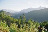
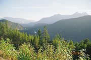 The Canadian Rockies
and the fjords along the Inside Passage's
, which are part of the Coast Mountains
, provide some of British Columbia's renowned and spectacular scenery. These landforms provide the backdrop and context for a growing outdoor adventure and ecotourism
industry. In the southwestern corner of B.C., the Lower Fraser Valley forms a flat, fertile triangle of intensively used land. The Okanagan
is one of only three wine-growing regions in Canada
and also produces cider
s. While exports are minimal, BC wines are highly prized and ranked well internationally. The city of Penticton and the small towns Oliver
, and Osoyoos
have some of the warmest summer climates in Canada, although the hottest spots are the towns of Lillooet
and Lytton
in the Fraser Canyon
. Nearly all of the Coast
including much of Vancouver Island
is covered by a temperate rain forest. One-third of the province consists of barren alpine tundra
, icefields, and glacier
s.
in the province's northeast, the British Columbia portion of which is part of the Alberta Plateau. The rest of the province is part of the Western Cordillera of North America, often referred to in Canada as the Pacific Cordillera or Canadian Cordillera. The Cordillera is subdivided into four main "systems" (which are distinct from the corresponding region's geologic provinces):
B.C.'s Eastern Mountain System comprises the dominant Canadian Rockies, with the Cariboo
, Selkirk
, Monashee
, and Purcell
ranges of the Columbia Mountains
system in the south. The Canadian Rockies incorporate the Canadian segment of the North American Rocky Mountains
range
. The southern end in Alberta and British Columbia borders Idaho and Montana of the United States. The northern end is at the Liard Plain in British Columbia.
The Interior System comprises the Interior Plateau
and Interior Mountains
(aka the Northern Interior Mountains) and the southern part of the Yukon Plateau
. The major subdivisions of the Interior Mountains are the Cassiar Mountains
, Omineca Mountains
, Stikine Plateau
, Skeena Mountains
and Hazelton Mountains
. Each has a variety of subranges and some definitions include the Tahltan Highland
and Tagish Highland
which may also be assigned to the Boundary Ranges
of the Coast Mountains
(see next). The major subdivisions of the Interior Plateau
are the Nechako Plateau
, the McGregor Plateau
, the Fraser Plateau
(which includes the Chilcotin Plateau
and Cariboo Plateau
and a number of small mountain ranges) and the Thompson Plateau
. The Quesnel
, Shuswap
and Okanagan Highland
s which flank the plateau to the east are sometimes seen as part of it, but are officially part of the Columbia Mountains
range-system and are seen as subranges of the adjoining ranges, namely the Cariboo Mountains
and Monashee Mountains
.
The Western System comprises the Coast Mountains
, the Canadian portion of the Cascade Mountains
(known in the US as the Cascade Range), the southeastern most Saint Elias Mountains
and the Coastal Trough, which includes the Georgia Depression
and its subunit the Fraser Lowland
and other low-lying coastal areas.
The Western Mountain System's Coast Mountains
are the westernmost range of the Pacific Cordillera
, running along the western shore of the North American continent, extending south from the Alaska Panhandle and covering most of coastal British Columbia. The range is covered in dense temperate rainforest on its western exposures, the range rises to heavily glaciated peaks, including the largest temperature-latitude icefields in the world, and then tapers to the dry Interior Plateau
on its eastern flanks, or to the subarctic boreal forest of the Skeena Mountains and Stikine Plateau.
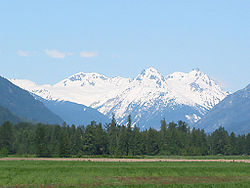
Mount Waddington
(4016 m) is the highest mountain within B.C. and Fairweather Mountain
in the Fairweather Range
of the Saint Elias Mountains
on the B.C. and Alaska border has the highest point. Much of the B.C. coast has a fjord scenery, due to the many islands along the Pacific coast being the highest points of a partly submerged mountain range.
The Insular System comprises the Insular Mountains
, which include the Vancouver Island Ranges
and Queen Charlotte Mountains
as well as the Nanaimo Lowland, Nahwitti Lowland and Hecate Depression.
During the Ice age
all of British Columbia was covered by ice (except Haida Gwaii and Brooks Peninsula).
British Columbia's principal mountains by range and height >
Mountain
Height (m)
Mountain
Height (m)
Saint Elias Mountains
Rocky Mountains (cont.)
Fairweather Mountain (highest point on Alaska–B.C. boundary)
4,663
Mount Assiniboine
(on Alberta–B.C. boundary)
3,618
Mount Quincy Adams
(on Alaska–B.C. boundary)
4,133
Mount Goodsir: North Tower
3,581
Mount Root (on Alaska–B.C. boundary)
3,901
Mount Goodsir: South Tower
3,520
Coast Mountains
Snow Dome
(on Alberta–B.C. boundary)
3,520
Mount Waddington
4,016
Mount Bryce
3,507
Mount Tiedemann
3,848
Selkirk Mountains
Combatant Mountain
3,756
Mount Sir Sandford
3,522
Asperity Mountain
3,716
Cariboo Mountains
Serra Peaks
3,642
Mount Sir Wilfrid Laurier
3,520
Monarch Mountain
3,459
Purcell Mountains
Rocky Mountains
Mount Farnham
3,481
Mount Robson
3,954
Monashee Mountains
Mount Columbia
(on Alberta–B.C. boundary)
3,747
Mount Monashee
3,274
Mount Clemenceau
3,642
Hallam Peak
3,205
Source Statistics Canada
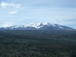
 Although little-known to the general public, British Columbia is home to a huge area of volcano
es and volcanic activity in the Pacific Ring of Fire
. Several mountains that many British Columbians look at every day are dormant volcanoes. Most of them have erupted during the Pleistocene
and Holocene
. Although none of Canada's volcanoes are currently erupting, several volcanoes, volcanic field
s, and volcanic centers are considered potentially active, 49 of which have erupted in the past 10,000 years and many of which have been active in the past two million years. There are hot spring
s at some volcanoes while 10 volcanoes in British Columbia appear related to seismic activity
since 1975, including: Mount Silverthrone
, Mount Meager
, Wells Gray-Clearwater volcanic field
, Mount Garibaldi
, Mount Cayley
, Castle Rock
, The Volcano
, Mount Edziza
, Hoodoo Mountain
and Crow Lagoon
. Numerous shield volcano
es developed during the Tertiary
period in north-central British Columbia and some were active intermittently to recent times. Mount Edziza
and the Level Mountain Range
are most spectacular examples. Mount Edziza is a stratovolcano
consisting of a basal shield of basalt
ic flows surmounted by a central vent and flanked by numerous satellite cones, ash beds and blocky lavas. The complex has a long history of volcanic eruption that began about 10 million years ago and ended about 1300 years ago. The volcanoes are grouped into four volcanic belt
s with different tectonic settings.
The Garibaldi Volcanic Belt
is a north-south range of volcanoes in southwestern British Columbia. It is the northern extension of the Cascade Volcanic Arc
in the United States
and contains the most explosive young volcanoes in Canada. It was formed by subduction
of the Juan de Fuca Plate
at the Cascadia subduction zone
. Eruption styles within the belt range from effusive
to explosive
, with compositions from basalt
to rhyolite
. The most recent major catastrophic eruption was the 2350 BP eruption of Mount Meager. It produced an ash column
at least 20 km high into the stratosphere
and dam
med the Lillooet River
with breccia
.
The Anahim Volcanic Belt
is an east-west line of volcanoes. These volcanoes probably formed when the North American Plate
moved over the Anahim hotspot
. The hotspot
is considered similar to the one feeding the Hawaiian Islands
. The last volcanic eruption within the belt was about 7000 years ago at a small cinder cone
called Nazko Cone
.
The Northern Cordilleran Volcanic Province
(sometimes called the Stikine Volcanic Belt) is the most active volcanic region in Canada, containing more than 100 volcanoes. Several eruptions are known to have occurred within this region in the past 400 years and contains Canada's largest volcanoes. It formed as a result of faulting
, cracking
, rift
ing and the interaction between the Pacific
and the North American
plates.
The Chilcotin Group in southern British Columbia is thought to have formed as a result of back-arc extension
behind the Cascadia subduction zone
.
The Wells Gray-Clearwater volcanic field
in southeastern British Columbia consists of numerous small, basalt
ic volcanoes and extensive lava
flows. Many individual volcanoes in the field have been active for the last 3 million years during which time the region was covered by thick glacial ice at least twice, prior to the well known Fraser Glaciation (also known as the Wisconsin Glaciation
). The origin of the volcanism is yet unknown but is probably related to crustal
thining. The last eruption in the field was at Kostal Cone
in 1500. Volcanism within the field has also created the 465 feet (141.7 m)-high Helmcken Falls
, which is the fourth highest waterfall
in Canada. It owes its foundation to the deposits of volcanic rock
that were placed down in the wide valley
of the Murtle River
. Layer upon layer of fresh lava created flat areas, over which enormous flood
s flowed during the last ice age
. These floods shaped the upright cliff
in the lava flows over which the river
now flows. The protection of Helmcken Falls was one of the major causes for the development of Wells Gray Provincial Park
. As a result, if it had not been for the volcanic eruptions, it is not likely that such a large wilderness region would have been made.
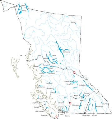
 The Fraser River
forms an important transportation corridor when it drains much of central and southern British Columbia flowing to the Pacific Ocean. Other major rivers include the upper Columbia River
and the Kootenay River
. In the northern B.C. the Stikine
, Nass
and Skeena River
s flow toward the Pacific Ocean, and Peace River
flows northeast toward the Arctic Ocean
. Hydroelectric resources in B.C. are highly developed, and pulp and paper and lumber mills are common throughout the province. The Fraser, Nass, and Skeena rivers have not been dammed in order to protect the salmon runs on them. Rivers and their valleys have for a long time provided routes through the mountains for people in B.C.
Long, narrow lakes are found throughout the valleys of the Southern and Central Interior
. Among these are Atlin
, Kootenay
, Okanagan
, Quesnel
, and Shuswap Lake
s. Several high dams have impounded large reservoir lakes like Kinbasket Lake
, particularly on the Columbia (see Hydroelectric dams on the Columbia River
) and Peace Rivers. Williston Lake
, on the Peace River, is the province’s largest body of freshwater.
British Columbia's principal rivers and their tributaries >
River
Drainage area (km²)
Length (km)
Discharge (m^3/s)
Columbia (mouth to head of Columbia Lake)
668,000
2,000
7,500
(International boundary to head of Columbia Lake)
102,800
801
2,800
Kootenay
37,700
780
782
Kettle (to head of Holmes Lake)
4,700
336
82.2
Okanagan (to head of Okanagan Lake)
21,600
314
18.3
Fraser
232,300
1,370
3,340
Thompson (to head of North Thompson)
55,400
489
772
North Thompson
20,700
338
427
South Thompson (to head of Shuswap)
17,800
332
292
Nechako (to head of Eutsuk Lake)
47,100
462
277
Stuart (to head of Driftwood)
16,200
415
131
Skeena
54,400
579
911
Stikine
49,800
539
1,580
Nass
21,100
380
780
Peace (to head of Finlay)
302,500
1,923
1,540
Source Statistics Canada
Source Environment Canada
British Columbia's principal lakes with relevant information >
Lake
Area (km²)
Altitude (m)
Depth (m)
Volume (km³)
Williston
1,761
671
166
70.3
Atlin
589 - 775
668
283
54
Kootenay
389
530
154
36.7
Okanagan
351
342
230
24.6
Shuswap
310
347
161
19.1
Quesnel
270
729
>600
-
Sources Statistics Canada, WLD, anglersatlas.com
 British Columbia's climate is best described as varied. The mountainous terrain causes huge changes in climatic conditions over short distances. All winter long the coast is pounded with storm after storm off the Pacific Ocean. The Coast Mountains
, Cascades
and also the Skeena
and Hazelton Mountains
block most of the precipitation which forces the majority of the precipitation to fall on the West side of the mountains. In contrast, the leeward side is much drier with some areas classified as semi-arid. The Coast of British Columbia is by far the wettest area in Canada, while areas located 150–200 km inland are some of the driest places in Canada outside of the High Arctic.
Coastal British Columbia experiences the mildest winters in Canada where freezing temperatures are infrequent. Victoria, generally considered the mildest city in Canada, has gone an entire winter without freezing. Along with the moderating effect of the Pacific Ocean
, the mountains impede the flow of the cold arctic air during the winter. The only exception is the northeastern portion of the province situated on the eastern side of the Rocky Mountains. Without the protection of the mountains, the climate is similar to that found in the neighboring parts of Alberta. The winters are very cold and the summers are warmer than areas west of the Rockies.
Summer daytime temperatures in the Southwestern Interior are the hottest in Canada. During July and August, the average daily maximum temperature around Osoyoos
and Spences Bridge is over 29 °C (84.2 °F), though Lillooet
and Lytton
erroneously claim to be hotter and vie for the title of "Canada's Hot Spot". This heat combined with little precipitation means that arid animals and vegetation thrive. Although winter temperatures are much colder than Coastal British Columbia, this area is still milder than almost anywhere else in Canada. Southern Interior valleys, including the Okanagan Valley, are spared the incessant precipitation found on the coast, but they receive some of the lowest amounts of bright sunshine in Canada during the winter months. This is a result of winter temperature inversions that leave the valleys in a layer of thick cloud while the rest of the province basks in sunshine.
Source: Environment Canada, Canadian Climate Normals or Averages 1971-2000
Source: Environment Canada, Weather Winners WebSite
British Columbia contains seven of Canada's national parks:
BC also contains a large network of provincial parks, run by BC Parks of the Ministry of Water, Land and Air Protection.
In addition to parks, British Columbia also protects approximately 47,000 square kilometers of agricultural land via the Agricultural Land Reserve
.
subdivides British Columbia into a system of ecozone
s, each containing smaller ecoregions. The ecozones within British Columbia include the Pacific Marine, Pacific Maritime, Boreal Cordillera, Montane Cordillera, Taiga Plains, and Boreal Plains Ecozones. The system used was established by the trilateral Commission for Environmental Cooperation
and as such is parallel to that used by the Environmental Protection Agency in the United States, though their system uses different names for the same ecozones and ecoregions, and to a similar ecoregional subdivision of Mexico
.
:
, nearly all of British Columbia is part of the Rocky Mountain Floristic Province.
and grazing leases, and also manage Ministry of Forests recreation sites and campgrounds. Other important subdivisions are Ministry of Environment regions (which controls water rights and management, environmental oversight, pesticide and herbicide permits, the British Columbia Conservation Officer Service
and Fish and Wildlife Branch; the provincial parks are managed by a sub-department of the Ministry of Environment, BC Parks), health regions (which administer health funding, hospitals and ambulance services), school districts (whose taxation authority is distinct from that of regional districts and organized by tax assessment areas), and mining districts (whose authority under the Mines Act supersedes nearly all other jurisdictions). The Ministry of Tourism also has a system of tourism regions, and the Ministry of Industry, Trade and Small Business Development divides the province into development regions, with BC Stats using a different regionalization system than that of Statistics Canada, which uses regional district boundaries to organize its data. Also very important is a system of Regional Management Planning Boards, which are "roundtable"-type planning authorities on which local stakeholders ranging from taxpayer and industry groups, municipalities and chambers of commerce, Ministry of Forests and Ministry of Environment/BC Parks and in some cases First Nations hammer out long-range plans for regional land-use management.
The provincial judicial system also subdivides the province into counties
, though this is mostly only procedural and does not impact directly on daily life.
All such regions and underlying title and survey descriptions are organized by Land Districts, which are the cadastral survey system underlying all legal descriptions in the province and date from the original Lands Act in the days of the Colony of British Columbia
and Colony of Vancouver Island
.
In order to fund community-wide services, such as a sewer system, urban areas incorporate to form municipalities. The vast majority of British Columbians live in these municipalities but there are also large areas of unincorporated rural areas around the municipalities. In 1964 the provincial government created regional districts, through amendments to the Municipal Act, to better coordinate regional issues and provide community services to unincorporated areas. Only one area, the sparsely populated Stikine Region in northwest B.C., is not covered by a regional district and municipal-type powers are administered directly by the provincial government. The Stikine Region has a permanent population of only 1,352 people, most of them aboriginal, and covers an area of 135,391 square kilometers with no municipalities within its borders. its only major towns being Atlin
and Telegraph Creek. Most planning in that region is governed by the Ministry of Energy, Mines and Petroleum Resources (forestry is only a small player in the region's economy as yet). All the regional districts and municipalities are members of the Union of British Columbia Municipalities. The former Sechelt Indian Band is now a municipal-type government, the Sechelt Indian Government District, and former Indian Reserves are now fee-simple lands within that effective municipality.
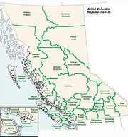 Since 1966-67, British Columbia has been carved into 27 regional districts as a way of extending municipal powers outside of municipalities. These regional districts are governed by boards composed of representatives of member municipalities and electoral areas. The unincorporated area of the regional district is carved into electoral areas. Each electoral area elects one director who sits on the Regional Board and the Electoral Area Directors Committee. The Islands Trust acts similar to a regional district for most of the unincorporated islands in the Gulf of Georgia between the Mainland and Vancouver Island, which are part of various regional districts though the Islands Trust supersedes them in planning and zoning authority.
The regional districts are used to provide local government services (mostly zoning, building inspection, etc.) to unincorporated areas, sub-regional services (e.g. street bridge over a border) between two or more members, regional parks, and regional services (e.g. funding the regional hospital district) required for the entire area. Also, as a collection of municipalities they are able to borrow funds for capital projects at lower interest rates.
.
 For representation in the Legislative Assembly
B.C. is carved into 79 electoral districts. Each one of these ridings elects one candidate to become its Member of the Legislative Assembly
(MLA) in a first past the post race contained within the electoral district. Patterns of voting established by the right-wing predecessors of the BC Liberal Party, the BC Social Credit Party
and the wartime Liberal-Conservative Coalition dominated provincial politics for much of the latter part of the twentieth century and enjoyed power bases on Vancouver's West Side, Victoria's richer suburbs, on the south bank of the Fraser Valley and in the Okanagan
and the province's Central Interior and Northeast. The New Democratic Party has traditionally drawn its support from more urbanized areas such as Vancouver and Victoria, as well as the North Coast and northwest Interior, plus the mining towns of the Kootenays and key areas of Vancouver Island. Swing areas include the BC Interior, certain urban areas within the Lower Mainland (like Surrey) and certain rural areas (like in southeastern BC). The fledgling Green Party has had no electoral victories but has come close in certain core areas of Green voting strength, namely the Sunshine Coast and Gulf Islands.
. Regional voting patterns are similar to those for provincial ridings, except that many voters vote differently federally than they do provincially, particularly on the right.
British Columbia
British Columbia is the westernmost of Canada's provinces and is known for its natural beauty, as reflected in its Latin motto, Splendor sine occasu . Its name was chosen by Queen Victoria in 1858...
is the westernmost province of Canada
Canada
Canada is a North American country consisting of ten provinces and three territories. Located in the northern part of the continent, it extends from the Atlantic Ocean in the east to the Pacific Ocean in the west, and northward into the Arctic Ocean...
, bordered by the Pacific Ocean
Pacific Ocean
The Pacific Ocean is the largest of the Earth's oceanic divisions. It extends from the Arctic in the north to the Southern Ocean in the south, bounded by Asia and Australia in the west, and the Americas in the east.At 165.2 million square kilometres in area, this largest division of the World...
. With an area of 944735 square kilometres (364,764.2 sq mi) it is Canada's third-largest province
Provinces and territories of Canada
The provinces and territories of Canada combine to make up the world's second-largest country by area. There are ten provinces and three territories...
. The province is nearly four times the size of Great Britain
Great Britain
Great Britain or Britain is an island situated to the northwest of Continental Europe. It is the ninth largest island in the world, and the largest European island, as well as the largest of the British Isles...
, two and one-half times larger than Japan
Japan
Japan is an island nation in East Asia. Located in the Pacific Ocean, it lies to the east of the Sea of Japan, China, North Korea, South Korea and Russia, stretching from the Sea of Okhotsk in the north to the East China Sea and Taiwan in the south...
and larger than every U.S.
United States
The United States of America is a federal constitutional republic comprising fifty states and a federal district...
state except Alaska
Alaska
Alaska is the largest state in the United States by area. It is situated in the northwest extremity of the North American continent, with Canada to the east, the Arctic Ocean to the north, and the Pacific Ocean to the west and south, with Russia further west across the Bering Strait...
. It is bounded on the northwest by the U.S. state of Alaska, directly north by Yukon
Yukon
Yukon is the westernmost and smallest of Canada's three federal territories. It was named after the Yukon River. The word Yukon means "Great River" in Gwich’in....
and the Northwest Territories
Northwest Territories
The Northwest Territories is a federal territory of Canada.Located in northern Canada, the territory borders Canada's two other territories, Yukon to the west and Nunavut to the east, and three provinces: British Columbia to the southwest, and Alberta and Saskatchewan to the south...
, on the east by Alberta
Alberta
Alberta is a province of Canada. It had an estimated population of 3.7 million in 2010 making it the most populous of Canada's three prairie provinces...
, and on the south by the U.S. states of Washington, Idaho
Idaho
Idaho is a state in the Rocky Mountain area of the United States. The state's largest city and capital is Boise. Residents are called "Idahoans". Idaho was admitted to the Union on July 3, 1890, as the 43rd state....
, and Montana
Montana
Montana is a state in the Western United States. The western third of Montana contains numerous mountain ranges. Smaller, "island ranges" are found in the central third of the state, for a total of 77 named ranges of the Rocky Mountains. This geographical fact is reflected in the state's name,...
. The southern border of British Columbia was established by the 1846 Oregon Treaty
Oregon Treaty
The Oregon Treaty is a treaty between the United Kingdom and the United States that was signed on June 15, 1846, in Washington, D.C. The treaty brought an end to the Oregon boundary dispute by settling competing American and British claims to the Oregon Country, which had been jointly occupied by...
. The province is dominated by mountain range
Mountain range
A mountain range is a single, large mass consisting of a succession of mountains or narrowly spaced mountain ridges, with or without peaks, closely related in position, direction, formation, and age; a component part of a mountain system or of a mountain chain...
s, among them the Canadian Rockies
Canadian Rockies
The Canadian Rockies comprise the Canadian segment of the North American Rocky Mountains range. They are the eastern part of the Canadian Cordillera, extending from the Interior Plains of Alberta to the Rocky Mountain Trench of British Columbia. The southern end borders Idaho and Montana of the USA...
but dominantly the Coast Mountains
Coast Mountains
The Coast Mountains are a major mountain range, in the Pacific Coast Ranges, of western North America, extending from southwestern Yukon through the Alaska Panhandle and virtually all of the Coast of British Columbia. They are so-named because of their proximity to the sea coast, and are often...
, Cassiar Mountains and the Columbia Mountains
Columbia Mountains
The Columbia Mountains are a group of mountain ranges located in southeastern British Columbia, and partially in Montana, Idaho and Washington. The mountain range covers 135,952 km² . The range is bounded by the Rocky Mountain Trench on the east, and the Kootenay River on the south; their...
. Most of the population is concentrated on the Pacific
Pacific Ocean
The Pacific Ocean is the largest of the Earth's oceanic divisions. It extends from the Arctic in the north to the Southern Ocean in the south, bounded by Asia and Australia in the west, and the Americas in the east.At 165.2 million square kilometres in area, this largest division of the World...
coast, notably in the area of Vancouver
Vancouver
Vancouver is a coastal seaport city on the mainland of British Columbia, Canada. It is the hub of Greater Vancouver, which, with over 2.3 million residents, is the third most populous metropolitan area in the country,...
, located on the southwestern tip of the mainland, which is known as the Lower Mainland
Lower Mainland
The Lower Mainland is a name commonly applied to the region surrounding and including Vancouver, British Columbia, Canada. As of 2007, 2,524,113 people live in the region; sixteen of the province's thirty most populous municipalities are located there.While the term Lower Mainland has been...
.
Statistics
- Total area: 944,735 km²
- Land area: 925,186 km²
- Water area: 19,549 km² (2.1%)
Physical geography
British Columbia is customarily divided into three main regions, the InteriorBritish Columbia Interior
The British Columbia Interior or BC Interior or Interior of British Columbia, usually referred to only as the Interior, is one of the three main regions of the Canadian province of British Columbia, the other two being the Lower Mainland, which comprises the overlapping areas of Greater Vancouver...
, the Coast
British Columbia Coast
The British Columbia Coast or BC Coast is Canada's western continental coastline on the Pacific Ocean. The usage is synonymous with the term West Coast of Canada....
and the Lower Mainland
Lower Mainland
The Lower Mainland is a name commonly applied to the region surrounding and including Vancouver, British Columbia, Canada. As of 2007, 2,524,113 people live in the region; sixteen of the province's thirty most populous municipalities are located there.While the term Lower Mainland has been...
(though the last-named is technically part of the Coast). These are broken up by a loose and often overlapping system of cultural-geographic regions, often based on river basins but sometimes spanning them. Examples of the former would be the Kootenays
Kootenays
The Kootenay Region comprises the southeastern portion of British Columbia. It takes its name from the Kootenay River, which in turn was named for the Ktunaxa First Nation first encountered by explorer David Thompson.-Boundaries:The Kootenays are more or less defined by the Kootenay Land...
, the Okanagan
Okanagan
The Okanagan , also known as the Okanagan Valley and sometimes as Okanagan Country is a region located in the Canadian province of British Columbia defined by the basin of Okanagan Lake and the Canadian portion of the Okanagan River. As of 2009, the region's population is approximately 350,927. The...
, and the Chilcotin
Chilcotin District
The Chilcotin District of British Columbia is usually known simply as "the Chilcotin", and also in speech commonly as "the Chilcotin Country" or simply Chilcotin. It is a plateau and mountain region in British Columbia on the inland lea of the Coast Mountains on the west side of the Fraser River....
, while of the latter would be the Lillooet Country
Lillooet Country
The Lillooet Country, also referred to as the Lillooet District., is a region spanning from the central Fraser Canyon town of Lillooet west to the valley of the Lillooet River, and including the valleys in between, in the Southern Interior of British Columbia. Like other historical BC regions, it...
and Cariboo
Cariboo
The Cariboo is an intermontane region of British Columbia along a plateau stretching from the Fraser Canyon to the Cariboo Mountains. The name is a reference to the woodland caribou that were once abundant in the region...
. Important subareas of these include the Fraser Valley
Fraser Valley
The Fraser Valley is the section of the Fraser River basin in southwestern British Columbia downstream of the Fraser Canyon. The term is sometimes used to refer to the Fraser Canyon and stretches upstream from there, but in general British Columbian usage of the term refers to the stretch of the...
, part of the Lower Mainland, the Fraser Canyon
Fraser Canyon
The Fraser Canyon is an 84 km landform of the Fraser River where it descends rapidly through narrow rock gorges in the Coast Mountains en route from the Interior Plateau of British Columbia to the Fraser Valley...
(which overlaps with various regions) and the Robson Valley
Robson Valley
The Robson Valley is a geographic region of the Canadian province of British Columbia, comprising the section of the Rocky Mountain Trench that lies southeast of the city of Prince George following the Fraser River to the Yellowhead Pass. The name is derived from Mount Robson, which stands near...
, which is the uppermost basin of the Fraser River southeast of Prince George. Vancouver Island is seen as its own region within the Coast, as are the Haida Gwaii (Queen Charlotte Islands) and the Gulf Islands
Gulf Islands
The Gulf Islands are the islands in the Strait of Georgia , between Vancouver Island and the mainland of British Columbia, Canada....
.
Terrain
Canadian Rockies
The Canadian Rockies comprise the Canadian segment of the North American Rocky Mountains range. They are the eastern part of the Canadian Cordillera, extending from the Interior Plains of Alberta to the Rocky Mountain Trench of British Columbia. The southern end borders Idaho and Montana of the USA...
and the fjords along the Inside Passage's
Inside Passage
The Inside Passage is a coastal route for oceangoing vessels along a network of passages which weave through the islands on the Pacific coast of North America. The route extends from southeastern Alaska, in the United States, through western British Columbia, in Canada, to northwestern Washington...
, which are part of the Coast Mountains
Coast Mountains
The Coast Mountains are a major mountain range, in the Pacific Coast Ranges, of western North America, extending from southwestern Yukon through the Alaska Panhandle and virtually all of the Coast of British Columbia. They are so-named because of their proximity to the sea coast, and are often...
, provide some of British Columbia's renowned and spectacular scenery. These landforms provide the backdrop and context for a growing outdoor adventure and ecotourism
Ecotourism
Ecotourism is a form of tourism visiting fragile, pristine, and usually protected areas, intended as a low impact and often small scale alternative to standard commercial tourism...
industry. In the southwestern corner of B.C., the Lower Fraser Valley forms a flat, fertile triangle of intensively used land. The Okanagan
Okanagan
The Okanagan , also known as the Okanagan Valley and sometimes as Okanagan Country is a region located in the Canadian province of British Columbia defined by the basin of Okanagan Lake and the Canadian portion of the Okanagan River. As of 2009, the region's population is approximately 350,927. The...
is one of only three wine-growing regions in Canada
Canada
Canada is a North American country consisting of ten provinces and three territories. Located in the northern part of the continent, it extends from the Atlantic Ocean in the east to the Pacific Ocean in the west, and northward into the Arctic Ocean...
and also produces cider
Cider
Cider or cyder is a fermented alcoholic beverage made from apple juice. Cider varies in alcohol content from 2% abv to 8.5% abv or more in traditional English ciders. In some regions, such as Germany and America, cider may be termed "apple wine"...
s. While exports are minimal, BC wines are highly prized and ranked well internationally. The city of Penticton and the small towns Oliver
Oliver, British Columbia
Oliver is a community at the south end of the Okanagan Valley in the Southern Interior of British Columbia, Canada, with a population of 4370. The community of Oliver is made up of land governed by three different bodies: the Town of Oliver, the Regional District of Okanagan-Similkameen and the...
, and Osoyoos
Osoyoos, British Columbia
Osoyoos is a town in the southern part of the Okanagan Valley in British Columbia near the border with Washington state. The town is also adjacent to the Indian Reserve of the Osoyoos Indian Band. The origin of the name Osoyoos was the word suius meaning "narrowing of the waters" in the local...
have some of the warmest summer climates in Canada, although the hottest spots are the towns of Lillooet
Lillooet, British Columbia
Lillooet is a community on the Fraser River in western Canada, about up the British Columbia Railway line from Vancouver. Situated at an intersection of deep gorges in the lee of the Coast Mountains, it has a dry climate- of precipitation is recorded annually at the town's weather station,...
and Lytton
Lytton, British Columbia
Lytton in British Columbia, Canada, sits at the confluence of the Thompson River and Fraser River on the east side of the Fraser. The location has been inhabited by the Nlaka'pamux people for over 10,000 years, and is one of the earliest locations settled by non-natives in the Southern Interior of...
in the Fraser Canyon
Fraser Canyon
The Fraser Canyon is an 84 km landform of the Fraser River where it descends rapidly through narrow rock gorges in the Coast Mountains en route from the Interior Plateau of British Columbia to the Fraser Valley...
. Nearly all of the Coast
British Columbia Coast
The British Columbia Coast or BC Coast is Canada's western continental coastline on the Pacific Ocean. The usage is synonymous with the term West Coast of Canada....
including much of Vancouver Island
Vancouver Island
Vancouver Island is a large island in British Columbia, Canada. It is one of several North American locations named after George Vancouver, the British Royal Navy officer who explored the Pacific Northwest coast of North America between 1791 and 1794...
is covered by a temperate rain forest. One-third of the province consists of barren alpine tundra
Alpine tundra
Alpine tundra is a natural region that does not contain trees because it is at high altitude. Alpine tundra is distinguished from arctic tundra, because alpine soils are generally better drained than arctic soils...
, icefields, and glacier
Glacier
A glacier is a large persistent body of ice that forms where the accumulation of snow exceeds its ablation over many years, often centuries. At least 0.1 km² in area and 50 m thick, but often much larger, a glacier slowly deforms and flows due to stresses induced by its weight...
s.
Mountains and mountain ranges
The landforms of British Columbia include two major continental landforms, the Interior PlainsInterior Plains
The Interior Plains is a vast physiographic region that spreads across the Laurentian craton of central North America.-Geography:The Interior Plains are an extensive physiographic division encompassing 8 distinct physiographic provinces, the Interior Low Plateaus, Great Plains, Central Lowland,...
in the province's northeast, the British Columbia portion of which is part of the Alberta Plateau. The rest of the province is part of the Western Cordillera of North America, often referred to in Canada as the Pacific Cordillera or Canadian Cordillera. The Cordillera is subdivided into four main "systems" (which are distinct from the corresponding region's geologic provinces):
Eastern System
B.C.'s Eastern Mountain System comprises the dominant Canadian Rockies, with the Cariboo
Cariboo Mountains
The Cariboo Mountains are the northernmost subrange of the Columbia Mountains, which run down into the Spokane, Washington area of the United States and include the Selkirks, Monashees and Purcells. The Cariboo Mountains are entirely within the province of British Columbia, Canada. The range is...
, Selkirk
Selkirk Mountains
The Selkirk Mountains are a mountain range spanning the northern portion of the Idaho Panhandle, eastern Washington, and southeastern British Columbia. They begin at Mica Peak near Coeur d'Alene, Idaho and extend approximately 320 km north from the border. The range is bounded on its west,...
, Monashee
Monashee Mountains
The Monashee Mountains are a mountain range mostly in British Columbia, Canada, extending into the U.S. state of Washington. They stretch from north to south and from east to west. They are a subrange of the Columbia Mountains...
, and Purcell
Purcell Mountains
The Purcell Mountains are a mountain range in southeastern British Columbia, Canada. They are a subrange of the Columbia Mountains, which includes the Selkirk, Monashee, and Cariboo Mountains. They are located on the west side of the Rocky Mountain Trench in the area of the Columbia Valley, and on...
ranges of the Columbia Mountains
Columbia Mountains
The Columbia Mountains are a group of mountain ranges located in southeastern British Columbia, and partially in Montana, Idaho and Washington. The mountain range covers 135,952 km² . The range is bounded by the Rocky Mountain Trench on the east, and the Kootenay River on the south; their...
system in the south. The Canadian Rockies incorporate the Canadian segment of the North American Rocky Mountains
Rocky Mountains
The Rocky Mountains are a major mountain range in western North America. The Rocky Mountains stretch more than from the northernmost part of British Columbia, in western Canada, to New Mexico, in the southwestern United States...
range
Mountain range
A mountain range is a single, large mass consisting of a succession of mountains or narrowly spaced mountain ridges, with or without peaks, closely related in position, direction, formation, and age; a component part of a mountain system or of a mountain chain...
. The southern end in Alberta and British Columbia borders Idaho and Montana of the United States. The northern end is at the Liard Plain in British Columbia.
Interior System
The Interior System comprises the Interior Plateau
Interior Plateau
The Interior Plateau comprises a large region of central British Columbia, and lies between the Cariboo and Monashee Mountains on the east, and the Hazelton Mountains, Coast Mountains and Cascade Range on the west. The continuation of the plateau into the United States is known there as the...
and Interior Mountains
Interior Mountains
The Interior Mountains, also called the Northern Interior Mountains and Interior Ranges, are the semi-official names for a huge area that comprises much of the northern two thirds of the Canadian province of British Columbia and a large area of southern Yukon...
(aka the Northern Interior Mountains) and the southern part of the Yukon Plateau
Yukon Plateau
The Yukon Plateau is a plateau comprising much of the central and southern Yukon Territory and the far northern part of British Columbia, Canada between Tagish Lake and the Cassiar Mountains and north of the Nakina River....
. The major subdivisions of the Interior Mountains are the Cassiar Mountains
Cassiar Mountains
The Cassiar Mountains are the most northerly group of the Northern Interior Mountains in the Canadian province of British Columbia and the Yukon Territory. They lie north and west of the Omineca Mountains, west of the northernmost Rockies and the Rocky Mountain Trench, north of the Hazelton...
, Omineca Mountains
Omineca Mountains
The Omineca Mountains, also known as "the Ominecas", are a group of remote mountain ranges in north-central British Columbia, Canada. They are bounded by the Finlay River on the north, the Rocky Mountain Trench on the east, the Nation River on the south, and the upper reaches of the Omineca River...
, Stikine Plateau
Stikine Plateau
The Stikine Plateau is a plateau in northern British Columbia, Canada. It lies between the Boundary Ranges of the Coast Mountains on the west and southwest and the Cassiar Mountains along its northeast, and between the Skeena Mountains on its south and southeast and the Jennings and Nakina Rivers...
, Skeena Mountains
Skeena Mountains
The Skeena Mountains, also known as the Skeenas, are a subrange of the Interior Mountains of northern British Columbia, Canada, essentially flanking the upper basin of the Skeena River. They lie just inland from the southern end of the Boundary Ranges of the Coast Mountains, and also of the...
and Hazelton Mountains
Hazelton Mountains
The Hazelton Mountains are a grouping of mountain ranges on the inland lee of the Kitimat Ranges of the Coast Mountains in northwestern British Columbia, Canada, spanning the area of Hazelton, British Columbia south to the Nechako Reservoir...
. Each has a variety of subranges and some definitions include the Tahltan Highland
Tahltan Highland
The Tahltan Highland is an upland area of plateau and relatively lower mountain ranges in British Columbia, Canada, lying east of the Boundary Ranges and south of the Inklin River...
and Tagish Highland
Tagish Highland
The Tagish Highland is an upland area on the inland side of the northernmost Boundary Ranges of the Coast Mountains, spanning far northwestern British Columbia from Atlin Lake to the area of the pass at Champagne, Yukon between the Alsek and Yukon Rivers...
which may also be assigned to the Boundary Ranges
Boundary Ranges
The Boundary Ranges, also known in the singular and as the Alaska Boundary Range, are the largest and most northerly subrange of the Coast Mountains...
of the Coast Mountains
Coast Mountains
The Coast Mountains are a major mountain range, in the Pacific Coast Ranges, of western North America, extending from southwestern Yukon through the Alaska Panhandle and virtually all of the Coast of British Columbia. They are so-named because of their proximity to the sea coast, and are often...
(see next). The major subdivisions of the Interior Plateau
Interior Plateau
The Interior Plateau comprises a large region of central British Columbia, and lies between the Cariboo and Monashee Mountains on the east, and the Hazelton Mountains, Coast Mountains and Cascade Range on the west. The continuation of the plateau into the United States is known there as the...
are the Nechako Plateau
Nechako Plateau
The Nechako Plateau is the northernmost subdivision of the Interior Plateau, one of the main geographic regions of the Canadian province of British Columbia...
, the McGregor Plateau
McGregor Plateau
The McGregor Plateau is a sub-plateau of the Fraser Plateau, the northernmost major subdivision of the Interior Plateau spanning the inland regions of the Pacific Northwest...
, the Fraser Plateau
Fraser Plateau
The Fraser Plateau is an intermontane plateau. It is one of the main subdivisions of the Interior Plateau located in the Central Interior of British Columbia, and includes the Cariboo and Chilcotin Plateaus and the adjoining Marble, Clear and Camelsfoot Ranges on its southwestern edge...
(which includes the Chilcotin Plateau
Chilcotin Plateau
The Chilcotin Plateau is part of the Fraser Plateau, a major subdivision of the Interior Plateau of British Columbia. The Chilcotin Plateau is physically near-identical with the region of the same name, i.e...
and Cariboo Plateau
Cariboo Plateau
The Cariboo Plateau is a volcanic plateau in south-central British Columbia, Canada. It is part of the Fraser Plateau that itself is a northward extension of the North American Plateau...
and a number of small mountain ranges) and the Thompson Plateau
Thompson Plateau
The Thompson Plateau, also known as the Okanagan-Thompson Plateau, forms the southern portion of the Interior Plateau of British Columbia, Canada, lying to the west of Okanagan Lake, south of the Thompson River and to the east of the Fraser River...
. The Quesnel
Quesnel Highland
The Quesnel Highland is a geographic area in the Central Interior of the Canadian province of British Columbia. As defined by BC government geographer in Landforms of British Columbia, an account and analysis of British Columbia geography that is often cited as authoritative...
, Shuswap
Shuswap Highland
The Shuswap Highland is a plateau-like hilly area of in British Columbia, Canada. It spans the upland area between the Bonaparte and Thompson Plateaus from the area of Mahood Lake, at the southeast corner of the Cariboo Plateau, southeast towards the lower Shuswap River east of Vernon in the...
and Okanagan Highland
Okanagan Highland
The Okanagan Highland is a plateau-like hilly area in British Columbia, Canada, and the U.S. state of Washington . It lies between the Okanagan Valley on its west and the Kettle River on its east, and geologically is more or less an extension of the Thompson Plateau, which lies west of the Okanagan...
s which flank the plateau to the east are sometimes seen as part of it, but are officially part of the Columbia Mountains
Columbia Mountains
The Columbia Mountains are a group of mountain ranges located in southeastern British Columbia, and partially in Montana, Idaho and Washington. The mountain range covers 135,952 km² . The range is bounded by the Rocky Mountain Trench on the east, and the Kootenay River on the south; their...
range-system and are seen as subranges of the adjoining ranges, namely the Cariboo Mountains
Cariboo Mountains
The Cariboo Mountains are the northernmost subrange of the Columbia Mountains, which run down into the Spokane, Washington area of the United States and include the Selkirks, Monashees and Purcells. The Cariboo Mountains are entirely within the province of British Columbia, Canada. The range is...
and Monashee Mountains
Monashee Mountains
The Monashee Mountains are a mountain range mostly in British Columbia, Canada, extending into the U.S. state of Washington. They stretch from north to south and from east to west. They are a subrange of the Columbia Mountains...
.
Western System
The Western System comprises the Coast Mountains
Coast Mountains
The Coast Mountains are a major mountain range, in the Pacific Coast Ranges, of western North America, extending from southwestern Yukon through the Alaska Panhandle and virtually all of the Coast of British Columbia. They are so-named because of their proximity to the sea coast, and are often...
, the Canadian portion of the Cascade Mountains
North Cascades
The North Cascades are a section of the Cascade Range of western North America. They span the border between the Canadian province of British Columbia and the U.S. state of Washington and are officially named in Canada as the Cascade Mountains...
(known in the US as the Cascade Range), the southeastern most Saint Elias Mountains
Saint Elias Mountains
The Saint Elias Mountains are a subgroup of the Pacific Coast Ranges, located in southeastern Alaska in the United States, southwestern Yukon and the very far northwestern part of British Columbia in Canada. The range spans Wrangell-St. Elias National Park and Preserve in the USA and Kluane...
and the Coastal Trough, which includes the Georgia Depression
Georgia Depression
The Georgia Depression is a landform in the Pacific Northwest, part of the Insular Mountain System of the North American Cordillera in British Columbia, Canada, and in Washington, United States...
and its subunit the Fraser Lowland
Fraser Lowland
The Fraser Lowland is a landform and physiographic region of the Pacific Northwest, in the Canadian province of British Columbia and the U.S. state of Washington. It includes much of the Lower Mainland region of British Columbia and a portion of Whatcom County, south of the Canada–US border...
and other low-lying coastal areas.
The Western Mountain System's Coast Mountains
Coast Mountains
The Coast Mountains are a major mountain range, in the Pacific Coast Ranges, of western North America, extending from southwestern Yukon through the Alaska Panhandle and virtually all of the Coast of British Columbia. They are so-named because of their proximity to the sea coast, and are often...
are the westernmost range of the Pacific Cordillera
Pacific Cordillera
The Pacific Cordillera is a top-level physiographic region of Canada. This cordillera is part of the Western Cordillera of North America. The mountain ranges in this region were covered during the Pleistocene by the Cordilleran Ice Sheet...
, running along the western shore of the North American continent, extending south from the Alaska Panhandle and covering most of coastal British Columbia. The range is covered in dense temperate rainforest on its western exposures, the range rises to heavily glaciated peaks, including the largest temperature-latitude icefields in the world, and then tapers to the dry Interior Plateau
Interior Plateau
The Interior Plateau comprises a large region of central British Columbia, and lies between the Cariboo and Monashee Mountains on the east, and the Hazelton Mountains, Coast Mountains and Cascade Range on the west. The continuation of the plateau into the United States is known there as the...
on its eastern flanks, or to the subarctic boreal forest of the Skeena Mountains and Stikine Plateau.
Mount Waddington
Mount Waddington
Mount Waddington, once known as Mystery Mountain, is the highest peak in the Coast Mountains of British Columbia, Canada. Although Mount Fairweather and Mount Quincy Adams, which straddle the US border between Alaska and British Columbia are taller, Mount Waddington is the highest peak that lies...
(4016 m) is the highest mountain within B.C. and Fairweather Mountain
Mount Fairweather
Mount Fairweather , is one of the world's highest coastal mountains at 4,671 metres It is located east of the Pacific Ocean on the border of Alaska, United States and western British Columbia, Canada...
in the Fairweather Range
Fairweather Range
The Fairweather Range is the unofficial name for a mountain range located in the U.S. state of Alaska and the Canadian province of British Columbia. It is the southernmost range of the Saint Elias Mountains...
of the Saint Elias Mountains
Saint Elias Mountains
The Saint Elias Mountains are a subgroup of the Pacific Coast Ranges, located in southeastern Alaska in the United States, southwestern Yukon and the very far northwestern part of British Columbia in Canada. The range spans Wrangell-St. Elias National Park and Preserve in the USA and Kluane...
on the B.C. and Alaska border has the highest point. Much of the B.C. coast has a fjord scenery, due to the many islands along the Pacific coast being the highest points of a partly submerged mountain range.
Insular System
The Insular System comprises the Insular Mountains
Insular Mountains
The Insular Mountains are a range of mountains in the Pacific Coast Ranges on the coast of British Columbia, Canada, comprising the Vancouver Island Ranges and Queen Charlotte Mountains. The Insular Mountains are rugged, particularly on Vancouver Island where peaks in Strathcona Provincial Park...
, which include the Vancouver Island Ranges
Vancouver Island Ranges
The Vancouver Island Ranges, formerly called the Vancouver Island Mountains, is a mountain range extending along the length of Vancouver Island which has an area of 31,788 km² . The Vancouver Island Ranges comprise the central and largest part of the island...
and Queen Charlotte Mountains
Queen Charlotte Mountains
The Queen Charlotte Mountains are a mountain range comprising all mountains and small mountain ranges of Haida Gwaii , British Columbia, Canada. It is the northernmost subrange of the Insular Mountains...
as well as the Nanaimo Lowland, Nahwitti Lowland and Hecate Depression.
Geology and orogeny
The younger ranges of the Canadian Rockies were uplifted during the late Cretaceous period (140 million-65 million years ago) and are a relatively new, tall and uneroded mountain range.During the Ice age
Ice age
An ice age or, more precisely, glacial age, is a generic geological period of long-term reduction in the temperature of the Earth's surface and atmosphere, resulting in the presence or expansion of continental ice sheets, polar ice sheets and alpine glaciers...
all of British Columbia was covered by ice (except Haida Gwaii and Brooks Peninsula).
Mount Assiniboine
Mount Assiniboine, also known as Assiniboine Mountain, is a mountain located on the Great Divide, on the British Columbia/Alberta border in Canada....
(on Alberta–B.C. boundary)
Mount Quincy Adams (Fairweather Range)
Mount Quincy Adams is a mountain located on the border between United States and Canada. It is named after John Quincy Adams , the sixth president of the United States....
(on Alaska–B.C. boundary)
Snow Dome (Canada)
Snow Dome is a mountain located on the Continental Divide in the Columbia Icefield, at the intersection of Banff National Park, and Jasper National Park, on the Alberta and British Columbia border in Canada.The mountain was named in 1898 by J...
(on Alberta–B.C. boundary)
Mount Waddington
Mount Waddington, once known as Mystery Mountain, is the highest peak in the Coast Mountains of British Columbia, Canada. Although Mount Fairweather and Mount Quincy Adams, which straddle the US border between Alaska and British Columbia are taller, Mount Waddington is the highest peak that lies...
Mount Bryce
Mount Bryce is a mountain at the southwestern corner of the Columbia Icefield, in British Columbia near the border with Alberta. It can be seen from the Icefields Parkway....
Mount Tiedemann
Mount Tiedemann is one of the principal summits of the Pacific Ranges subdivision of the Coast Mountains of British Columbia. It is located northeast of Mount Waddington in the Waddington Range massif between the Homathko and Klinaklini Rivers....
Mount Sir Sandford
Mount Sir Sandford is the highest mountain of the Sir Sandford Range and of the Big Bend Ranges of the Selkirk Mountains in southwestern British Columbia, Canada. It is the 12th highest peak in the province. The mountain was named after Sir Sandford Fleming, a railway engineer for the Canadian...
Asperity Mountain
Asperity Mountain is a mountain located in British Columbia, Canada, rising to . It is located between Tellot and Tiedemann Glaciers on the north and south respectively, in the Waddington Range, a subrange of the Pacific Ranges...
Mount Sir Wilfrid Laurier
Mount Sir Wilfrid Laurier is a mountain located in the Premier Range of the Cariboo Mountains in the east-central interior of British Columbia, Canada. The mountain is the tallest in the Premier Range, which is located just west of Valemount....
Monarch Mountain
Monarch Mountain is one of the principal summits of the Pacific Ranges subdivision of the Coast Mountains in southern British Columbia. It stands just east of a pass between the Klinaklini River and the south branch of the Atnarko River, which is a tributary of the Bella Coola River...
Mount Farnham
Mount Farnham is British Columbia's 17th highest peak, and 21st most prominence. It was named after Paulding Farnham from New York....
Mount Robson
Mount Robson is the most prominent mountain in North America's Rocky Mountain range; it is also the highest point in the Canadian Rockies. The mountain is located entirely within Mount Robson Provincial Park of British Columbia, and is part of the Rainbow Range. It is commonly thought to be the...
Mount Columbia (Alberta)
Mount Columbia is the highest point in Alberta, Canada and the second highest peak in the Canadian Rockies after Mount Robson. It is located on the border between Alberta and British Columbia on the northern edge of the Columbia Icefield. Its highest point, however, lies within Jasper National Park...
(on Alberta–B.C. boundary)
Mount Clémenceau
Mount Clemenceau is the fourth highest mountain in the Canadian Rockies. The peak was originally named "Pyramid" in 1892 by Arthur Coleman. The mountain was renamed by the Interprovincial Boundary Survey in 1919 to its present name, which is for Georges Clemenceau, premier of France during World...
Hallam Peak
Hallam Peak is a distinctive rock peak in the Kukri Hills, Victoria Land. The peak rises to 900 m between the heads of Von Guerard Glacier and Aiken Glacier and provides an unobstructed view of the Lake Fryxell locality of Taylor Valley. Named by Advisory Committee on Antarctic Names after Dr....
Source Statistics Canada
Volcanoes
Volcano
2. Bedrock3. Conduit 4. Base5. Sill6. Dike7. Layers of ash emitted by the volcano8. Flank| 9. Layers of lava emitted by the volcano10. Throat11. Parasitic cone12. Lava flow13. Vent14. Crater15...
es and volcanic activity in the Pacific Ring of Fire
Pacific Ring of Fire
The Pacific Ring of Fire is an area where large numbers of earthquakes and volcanic eruptions occur in the basin of the Pacific Ocean. In a horseshoe shape, it is associated with a nearly continuous series of oceanic trenches, volcanic arcs, and volcanic belts and/or plate movements...
. Several mountains that many British Columbians look at every day are dormant volcanoes. Most of them have erupted during the Pleistocene
Pleistocene
The Pleistocene is the epoch from 2,588,000 to 11,700 years BP that spans the world's recent period of repeated glaciations. The name pleistocene is derived from the Greek and ....
and Holocene
Holocene
The Holocene is a geological epoch which began at the end of the Pleistocene and continues to the present. The Holocene is part of the Quaternary period. Its name comes from the Greek words and , meaning "entirely recent"...
. Although none of Canada's volcanoes are currently erupting, several volcanoes, volcanic field
Volcanic field
A volcanic field is an area of the Earth's crust that is prone to localized volcanic activity. They usually contain 10 to 100 volcanoes, such as cinder cones and are usually in clusters. Lava flows may also occur...
s, and volcanic centers are considered potentially active, 49 of which have erupted in the past 10,000 years and many of which have been active in the past two million years. There are hot spring
Hot spring
A hot spring is a spring that is produced by the emergence of geothermally heated groundwater from the Earth's crust. There are geothermal hot springs in many locations all over the crust of the earth.-Definitions:...
s at some volcanoes while 10 volcanoes in British Columbia appear related to seismic activity
Seismology
Seismology is the scientific study of earthquakes and the propagation of elastic waves through the Earth or through other planet-like bodies. The field also includes studies of earthquake effects, such as tsunamis as well as diverse seismic sources such as volcanic, tectonic, oceanic,...
since 1975, including: Mount Silverthrone
Mount Silverthrone
Mount Silverthrone, officially named Silverthrone Mountain, is a mountain in the Regional District of Mount Waddington, British Columbia, located over northwest of the city of Vancouver and about west of Mount Waddington, British Columbia, Canada...
, Mount Meager
Mount Meager
Mount Meager, originally known as Meager Mountain, is a complex volcano in the Sea-to-Sky Corridor of southwestern British Columbia, Canada. It is located north of Vancouver at the northern end of the Pemberton Valley. Part of the Cascade Volcanic Arc of western North America, its summit is above...
, Wells Gray-Clearwater volcanic field
Wells Gray-Clearwater volcanic field
The Wells Gray-Clearwater volcanic field, also called the Clearwater Cone Group, is a potentially active monogenetic volcanic field in east-central British Columbia, Canada, located approximately north of Kamloops. It is situated in the Cariboo Mountains of the Columbia Mountains and on the...
, Mount Garibaldi
Mount Garibaldi
Mount Garibaldi is a potentially active stratovolcano in the Sea to Sky Country of British Columbia, north of Vancouver, Canada. Located in the southernmost Coast Mountains, it is one of the most recognized peaks in the South Coast region, as well as British Columbia's best known volcano...
, Mount Cayley
Mount Cayley
Mount Cayley is a potentially active stratovolcano in Squamish-Lillooet Regional District of southwestern British Columbia, Canada. Located north of Squamish and west of Whistler in the Pacific Ranges of the Coast Mountains, it rises above the Squamish River to the west and above the Cheakamus...
, Castle Rock
Castle Rock (volcano)
Castle Rock is a volcanic neck located west of Iskut and 8 km northwest of Tuktsayda Mountain in British Columbia, Canada. It is part of the Pacific Ring of Fire that includes over 160 active volcanoes and is in the Klastline Group, Northern Cordilleran Volcanic Province and last erupted in...
, The Volcano
The Volcano (British Columbia)
The Volcano, also known as Lava Fork volcano, is a small cinder cone in the Boundary Ranges of the Coast Mountains in northwestern British Columbia, Canada. It is located approximately northwest of the small community of Stewart near the head of Lava Fork...
, Mount Edziza
Mount Edziza
Mount Edziza is a stratovolcano in the Stikine Country of northwestern British Columbia, Canada. The volcano and the surrounding area are protected within Mount Edziza Provincial Park. It consists of a complex of multiple peaks and ridges, with several glaciers flowing in all directions. The summit...
, Hoodoo Mountain
Hoodoo Mountain
Hoodoo Mountain is a potentially active flat-topped stratovolcano in the Stikine Country of northwestern British Columbia, Canada, located northeast of Wrangell, Alaska on the north side of the lower Iskut River and east of its junction with the Stikine River...
and Crow Lagoon
Crow Lagoon
Crow Lagoon is a little-known volcanic center located north of Prince Rupert, British Columbia, Canada. There are beds of thick, basaltic tephra that are of Holocene age....
. Numerous shield volcano
Shield volcano
A shield volcano is a type of volcano usually built almost entirely of fluid lava flows. They are named for their large size and low profile, resembling a warrior's shield. This is caused by the highly fluid lava they erupt, which travels farther than lava erupted from more explosive volcanoes...
es developed during the Tertiary
Tertiary
The Tertiary is a deprecated term for a geologic period 65 million to 2.6 million years ago. The Tertiary covered the time span between the superseded Secondary period and the Quaternary...
period in north-central British Columbia and some were active intermittently to recent times. Mount Edziza
Mount Edziza
Mount Edziza is a stratovolcano in the Stikine Country of northwestern British Columbia, Canada. The volcano and the surrounding area are protected within Mount Edziza Provincial Park. It consists of a complex of multiple peaks and ridges, with several glaciers flowing in all directions. The summit...
and the Level Mountain Range
Level Mountain Range
The Level Mountain Range, also known as Level Mountain, is a mountain range in Cassiar Country, northwestern British Columbia, Canada, located just northeast of Callison Ranch, southwest of Dease Lake and about north of Mount Edziza. It consists of a massive shield volcano and lies on the Nahlin...
are most spectacular examples. Mount Edziza is a stratovolcano
Stratovolcano
A stratovolcano, also known as a composite volcano, is a tall, conical volcano built up by many layers of hardened lava, tephra, pumice, and volcanic ash. Unlike shield volcanoes, stratovolcanoes are characterized by a steep profile and periodic, explosive eruptions...
consisting of a basal shield of basalt
Basalt
Basalt is a common extrusive volcanic rock. It is usually grey to black and fine-grained due to rapid cooling of lava at the surface of a planet. It may be porphyritic containing larger crystals in a fine matrix, or vesicular, or frothy scoria. Unweathered basalt is black or grey...
ic flows surmounted by a central vent and flanked by numerous satellite cones, ash beds and blocky lavas. The complex has a long history of volcanic eruption that began about 10 million years ago and ended about 1300 years ago. The volcanoes are grouped into four volcanic belt
Volcanic belt
A volcanic belt is a large volcanically active region. Other terms are used for smaller areas of activity, such as volcanic fields. Volcanic belts are found above zones of unusually high temperature where magma is created by partial melting of solid material in the Earth's crust and upper mantle....
s with different tectonic settings.
The Garibaldi Volcanic Belt
Garibaldi Volcanic Belt
The Garibaldi Volcanic Belt, also called the Canadian Cascade Arc, is a northwest-southeast trending volcanic chain in the Pacific Ranges of the Coast Mountains that extends from Watts Point in the south to the Ha-Iltzuk Icefield in the north. This chain of volcanoes is located in southwestern...
is a north-south range of volcanoes in southwestern British Columbia. It is the northern extension of the Cascade Volcanic Arc
Cascade Volcanoes
The Cascade Volcanoes are a number of volcanoes in a volcanic arc in western North America, extending from southwestern British Columbia through Washington and Oregon to Northern California, a distance of well over 700 mi ...
in the United States
United States
The United States of America is a federal constitutional republic comprising fifty states and a federal district...
and contains the most explosive young volcanoes in Canada. It was formed by subduction
Subduction
In geology, subduction is the process that takes place at convergent boundaries by which one tectonic plate moves under another tectonic plate, sinking into the Earth's mantle, as the plates converge. These 3D regions of mantle downwellings are known as "Subduction Zones"...
of the Juan de Fuca Plate
Juan de Fuca Plate
The Juan de Fuca Plate, named after the explorer of the same name, is a tectonic plate, generated from the Juan de Fuca Ridge, and subducting under the northerly portion of the western side of the North American Plate at the Cascadia subduction zone...
at the Cascadia subduction zone
Cascadia subduction zone
The Cascadia subduction zone is a subduction zone, a type of convergent plate boundary that stretches from northern Vancouver Island to northern California. It is a very long sloping fault that separates the Juan de Fuca and North America plates.New ocean floor is being created offshore of...
. Eruption styles within the belt range from effusive
Effusive eruption
An effusive eruption is a volcanic eruption characterized by the outpouring of lava onto the ground...
to explosive
Explosive eruption
An explosive eruption is a volcanic term to describe a violent, explosive type of eruption. Mount St. Helens in 1980 was an example. Such an eruption is driven by gas accumulating under great pressure. Driven by hot rising magma, it interacts with ground water until the pressure increases to the...
, with compositions from basalt
Basalt
Basalt is a common extrusive volcanic rock. It is usually grey to black and fine-grained due to rapid cooling of lava at the surface of a planet. It may be porphyritic containing larger crystals in a fine matrix, or vesicular, or frothy scoria. Unweathered basalt is black or grey...
to rhyolite
Rhyolite
This page is about a volcanic rock. For the ghost town see Rhyolite, Nevada, and for the satellite system, see Rhyolite/Aquacade.Rhyolite is an igneous, volcanic rock, of felsic composition . It may have any texture from glassy to aphanitic to porphyritic...
. The most recent major catastrophic eruption was the 2350 BP eruption of Mount Meager. It produced an ash column
Eruption column
An eruption column consists of hot volcanic ash emitted during an explosive volcanic eruption. The ash forms a column rising many kilometres into the air above the peak of the volcano. In the most explosive eruptions, the eruption column may rise over 40 km, penetrating the stratosphere...
at least 20 km high into the stratosphere
Stratosphere
The stratosphere is the second major layer of Earth's atmosphere, just above the troposphere, and below the mesosphere. It is stratified in temperature, with warmer layers higher up and cooler layers farther down. This is in contrast to the troposphere near the Earth's surface, which is cooler...
and dam
Dam
A dam is a barrier that impounds water or underground streams. Dams generally serve the primary purpose of retaining water, while other structures such as floodgates or levees are used to manage or prevent water flow into specific land regions. Hydropower and pumped-storage hydroelectricity are...
med the Lillooet River
Lillooet River
The Lillooet River is a major river of the southern Coast Mountains of British Columbia. It begins at Silt Lake, on the southern edge of the Lillooet Crown Icecap about 80 kilometres northwest of Pemberton and about 85 kilometres northwest of Whistler...
with breccia
Breccia
Breccia is a rock composed of broken fragments of minerals or rock cemented together by a fine-grained matrix, that can be either similar to or different from the composition of the fragments....
.
The Anahim Volcanic Belt
Anahim Volcanic Belt
The Anahim Volcanic Belt is a long volcanic belt, stretching from just north of Vancouver Island to near Quesnel, British Columbia, Canada. The Anahim Volcanic Belt has had three main magmatic episodes: 15–13 Ma, 9–6 Ma, and 3–1 Ma. The volcanoes generally become younger eastward at a rate of to ...
is an east-west line of volcanoes. These volcanoes probably formed when the North American Plate
North American Plate
The North American Plate is a tectonic plate covering most of North America, Greenland, Cuba, Bahamas, and parts of Siberia, Japan and Iceland. It extends eastward to the Mid-Atlantic Ridge and westward to the Chersky Range in eastern Siberia. The plate includes both continental and oceanic crust...
moved over the Anahim hotspot
Anahim hotspot
The Anahim hotspot is a volcanic hotspot in central British Columbia, Canada. It is situated on the Interior Plateau, a large region that lies between the Cariboo and Monashee Mountains to the east, and the Hazelton Mountains, Coast Mountains and Cascade Range to the west...
. The hotspot
Hotspot (geology)
The places known as hotspots or hot spots in geology are volcanic regions thought to be fed by underlying mantle that is anomalously hot compared with the mantle elsewhere. They may be on, near to, or far from tectonic plate boundaries. There are two hypotheses to explain them...
is considered similar to the one feeding the Hawaiian Islands
Hawaiian Islands
The Hawaiian Islands are an archipelago of eight major islands, several atolls, numerous smaller islets, and undersea seamounts in the North Pacific Ocean, extending some 1,500 miles from the island of Hawaii in the south to northernmost Kure Atoll...
. The last volcanic eruption within the belt was about 7000 years ago at a small cinder cone
Cinder cone
According to the , Cinder Cone is the proper name of 1 cinder cone in Canada and 7 cinder cones in the United States:In Canada: Cinder Cone In the United States:...
called Nazko Cone
Nazko Cone
Nazko Cone is a small potentially active basaltic cinder cone in central British Columbia, Canada, located 75 km west of Quesnel and 150 kilometers southwest of Prince George. It is considered the easternmost volcano in the Anahim Volcanic Belt. The small tree-covered cone rises 120 m above...
.
The Northern Cordilleran Volcanic Province
Northern Cordilleran volcanic province
The Northern Cordilleran Volcanic Province , formerly known as the Stikine Volcanic Belt, is a geologic province defined by the occurrence of Miocene to Holocene volcanoes in the Pacific Northwest of North America...
(sometimes called the Stikine Volcanic Belt) is the most active volcanic region in Canada, containing more than 100 volcanoes. Several eruptions are known to have occurred within this region in the past 400 years and contains Canada's largest volcanoes. It formed as a result of faulting
Geologic fault
In geology, a fault is a planar fracture or discontinuity in a volume of rock, across which there has been significant displacement along the fractures as a result of earth movement. Large faults within the Earth's crust result from the action of tectonic forces...
, cracking
Cracking
Cracking may refer to:* Cracking, the formation of a fracture or partial fracture in a solid material* Fluid catalytic cracking, a catalytic process widely used in oil refineries for cracking large hydrocarbon molecules into smaller molecules...
, rift
Rift
In geology, a rift or chasm is a place where the Earth's crust and lithosphere are being pulled apart and is an example of extensional tectonics....
ing and the interaction between the Pacific
Pacific Plate
The Pacific Plate is an oceanic tectonic plate that lies beneath the Pacific Ocean. At 103 million square kilometres, it is the largest tectonic plate....
and the North American
North American Plate
The North American Plate is a tectonic plate covering most of North America, Greenland, Cuba, Bahamas, and parts of Siberia, Japan and Iceland. It extends eastward to the Mid-Atlantic Ridge and westward to the Chersky Range in eastern Siberia. The plate includes both continental and oceanic crust...
plates.
The Chilcotin Group in southern British Columbia is thought to have formed as a result of back-arc extension
Back-arc basin
Back-arc basins are geologic features, submarine basins associated with island arcs and subduction zones.They are found at some convergent plate boundaries, presently concentrated in the Western Pacific ocean. Most of them result from tensional forces caused by oceanic trench rollback and the...
behind the Cascadia subduction zone
Cascadia subduction zone
The Cascadia subduction zone is a subduction zone, a type of convergent plate boundary that stretches from northern Vancouver Island to northern California. It is a very long sloping fault that separates the Juan de Fuca and North America plates.New ocean floor is being created offshore of...
.
The Wells Gray-Clearwater volcanic field
Wells Gray-Clearwater volcanic field
The Wells Gray-Clearwater volcanic field, also called the Clearwater Cone Group, is a potentially active monogenetic volcanic field in east-central British Columbia, Canada, located approximately north of Kamloops. It is situated in the Cariboo Mountains of the Columbia Mountains and on the...
in southeastern British Columbia consists of numerous small, basalt
Basalt
Basalt is a common extrusive volcanic rock. It is usually grey to black and fine-grained due to rapid cooling of lava at the surface of a planet. It may be porphyritic containing larger crystals in a fine matrix, or vesicular, or frothy scoria. Unweathered basalt is black or grey...
ic volcanoes and extensive lava
Lava
Lava refers both to molten rock expelled by a volcano during an eruption and the resulting rock after solidification and cooling. This molten rock is formed in the interior of some planets, including Earth, and some of their satellites. When first erupted from a volcanic vent, lava is a liquid at...
flows. Many individual volcanoes in the field have been active for the last 3 million years during which time the region was covered by thick glacial ice at least twice, prior to the well known Fraser Glaciation (also known as the Wisconsin Glaciation
Wisconsin glaciation
The last glacial period was the most recent glacial period within the current ice age occurring during the last years of the Pleistocene, from approximately 110,000 to 10,000 years ago....
). The origin of the volcanism is yet unknown but is probably related to crustal
Crust (geology)
In geology, the crust is the outermost solid shell of a rocky planet or natural satellite, which is chemically distinct from the underlying mantle...
thining. The last eruption in the field was at Kostal Cone
Kostal Cone
Kostal Cone, also called Kostal Volcano, is a young cinder cone in Wells Gray Provincial Park in east-central British Columbia, Canada. It rises from the northeast shore of Kostal Lake in the Cariboo Mountains...
in 1500. Volcanism within the field has also created the 465 feet (141.7 m)-high Helmcken Falls
Helmcken Falls
Helmcken Falls is a waterfall on the Murtle River within Wells Gray Provincial Park in British Columbia, Canada. The protection of Helmcken Falls was one of the reasons for the creation of Wells Gray Provincial Park in 1939....
, which is the fourth highest waterfall
Waterfall
A waterfall is a place where flowing water rapidly drops in elevation as it flows over a steep region or a cliff.-Formation:Waterfalls are commonly formed when a river is young. At these times the channel is often narrow and deep. When the river courses over resistant bedrock, erosion happens...
in Canada. It owes its foundation to the deposits of volcanic rock
Volcanic rock
Volcanic rock is a rock formed from magma erupted from a volcano. In other words, it is an igneous rock of volcanic origin...
that were placed down in the wide valley
Valley
In geology, a valley or dale is a depression with predominant extent in one direction. A very deep river valley may be called a canyon or gorge.The terms U-shaped and V-shaped are descriptive terms of geography to characterize the form of valleys...
of the Murtle River
Murtle River
The Murtle River is a river in east-central British Columbia, Canada. It rises from a large unnamed glacier in the Cariboo Mountains at an elevation of and flows southwest for to the head of gigantic Murtle Lake. The river also drains Murtle Lake then flows southwest for into the Clearwater...
. Layer upon layer of fresh lava created flat areas, over which enormous flood
Flood
A flood is an overflow of an expanse of water that submerges land. The EU Floods directive defines a flood as a temporary covering by water of land not normally covered by water...
s flowed during the last ice age
Ice age
An ice age or, more precisely, glacial age, is a generic geological period of long-term reduction in the temperature of the Earth's surface and atmosphere, resulting in the presence or expansion of continental ice sheets, polar ice sheets and alpine glaciers...
. These floods shaped the upright cliff
Cliff
In geography and geology, a cliff is a significant vertical, or near vertical, rock exposure. Cliffs are formed as erosion landforms due to the processes of erosion and weathering that produce them. Cliffs are common on coasts, in mountainous areas, escarpments and along rivers. Cliffs are usually...
in the lava flows over which the river
River
A river is a natural watercourse, usually freshwater, flowing towards an ocean, a lake, a sea, or another river. In a few cases, a river simply flows into the ground or dries up completely before reaching another body of water. Small rivers may also be called by several other names, including...
now flows. The protection of Helmcken Falls was one of the major causes for the development of Wells Gray Provincial Park
Wells Gray Provincial Park
Wells Gray Provincial Park is a large wilderness park located in east-central British Columbia, Canada. The park protects most of the southern, and highest, regions of the Cariboo Mountains and covers 5,250 square kilometres...
. As a result, if it had not been for the volcanic eruptions, it is not likely that such a large wilderness region would have been made.
Water
Fraser River
The Fraser River is the longest river within British Columbia, Canada, rising at Fraser Pass near Mount Robson in the Rocky Mountains and flowing for , into the Strait of Georgia at the city of Vancouver. It is the tenth longest river in Canada...
forms an important transportation corridor when it drains much of central and southern British Columbia flowing to the Pacific Ocean. Other major rivers include the upper Columbia River
Columbia River
The Columbia River is the largest river in the Pacific Northwest region of North America. The river rises in the Rocky Mountains of British Columbia, Canada, flows northwest and then south into the U.S. state of Washington, then turns west to form most of the border between Washington and the state...
and the Kootenay River
Kootenay River
The Kootenay is a major river in southeastern British Columbia, Canada and the northern part of the U.S. states of Montana and Idaho. It is one of the uppermost major tributaries of the Columbia River, which is the largest North American river that empties into the Pacific Ocean...
. In the northern B.C. the Stikine
Stikine River
The Stikine River is a river, historically also the Stickeen River, approximately 610 km long, in northwestern British Columbia in Canada and southeastern Alaska in the United States...
, Nass
Nass River
The Nass River is a river in northern British Columbia, Canada. It flows from the Coast Mountains southwest to Nass Bay, a sidewater of Portland Inlet, which connects to the North Pacific Ocean via the Dixon Entrance...
and Skeena River
Skeena River
The Skeena River is the second longest river entirely within British Columbia, Canada . The Skeena is an important transportation artery, particularly for the Tsimshian and the Gitxsan - whose names mean "inside the Skeena River" and "people of the Skeena River" respectively, and also during the...
s flow toward the Pacific Ocean, and Peace River
Peace River (Canada)
The Peace River is a river in Canada that originates in the Rocky Mountains of northern British Columbia and flows to the northeast through northern Alberta. The Peace River flows into the Slave River, a tributary of the Mackenzie River. The Mackenzie is the 12th longest river in the world,...
flows northeast toward the Arctic Ocean
Arctic Ocean
The Arctic Ocean, located in the Northern Hemisphere and mostly in the Arctic north polar region, is the smallest and shallowest of the world's five major oceanic divisions...
. Hydroelectric resources in B.C. are highly developed, and pulp and paper and lumber mills are common throughout the province. The Fraser, Nass, and Skeena rivers have not been dammed in order to protect the salmon runs on them. Rivers and their valleys have for a long time provided routes through the mountains for people in B.C.
Long, narrow lakes are found throughout the valleys of the Southern and Central Interior
British Columbia Interior
The British Columbia Interior or BC Interior or Interior of British Columbia, usually referred to only as the Interior, is one of the three main regions of the Canadian province of British Columbia, the other two being the Lower Mainland, which comprises the overlapping areas of Greater Vancouver...
. Among these are Atlin
Atlin Lake
Atlin Lake is a lake in northwestern British Columbia and is that province's largest natural lake. The northern tip of the lake is in the Yukon, as is Little Atlin Lake. However, most of the lake lies within the Atlin District of British Columbia...
, Kootenay
Kootenay Lake
Kootenay Lake is a lake located in British Columbia, Canada and is part of theKootenay River. The lake has been raised by the Corra Linn Dam and has a dike system at the southern end, which, along with industry in the 1950s-70s, has changed the ecosystem in and around the water...
, Okanagan
Okanagan Lake
Okanagan Lake is a large, deep lake in the Okanagan Valley of British Columbia. The lake is 135 km long, between 4 and 5 km wide, and has a surface area of 351 km². The lake's maximum depth is 232 meters near Grant Island...
, Quesnel
Quesnel Lake
Quesnel Lake is a glacial lake or fjord in British Columbia, Canada, and is the origin of the Quesnel River. With a maximum depth of 610 meters , it is the deepest lake in British Columbia, though not the deepest lake in Canada, as is often claimed. That distinction belongs to Great Slave Lake...
, and Shuswap Lake
Shuswap Lake
Shuswap Lake is a lake located in south-central British Columbia, Canada that drains via the Little River into Little Shuswap Lake. Little Shuswap Lake is the source of the South Thompson River, a branch of the Thompson River, a tributary of the Fraser River...
s. Several high dams have impounded large reservoir lakes like Kinbasket Lake
Kinbasket Lake
Kinbasket Lake is a reservoir on the Columbia River in southeast British Columbia, north of the city of Revelstoke and the town of Golden. The reservoir was created by the construction of the Mica Dam. The lake includes two reaches, Columbia Reach and Canoe Reach , referring to the river valleys...
, particularly on the Columbia (see Hydroelectric dams on the Columbia River
Hydroelectric dams on the Columbia River
Hydroelectric dams on the Columbia River and its tributaries in North America.- Mainstem Columbia dams :-Snake River:-Pend Oreille-Clark Fork–Flathead:-Kootenai River:-See also:...
) and Peace Rivers. Williston Lake
Williston Lake
Williston Lake is a reservoir created by the W. A. C. Bennett Dam and is located in the Northern Interior of British Columbia, Canada.-Geography:...
, on the Peace River, is the province’s largest body of freshwater.
Source Statistics Canada
Source Environment Canada
Sources Statistics Canada, WLD, anglersatlas.com
Climate
Coast Mountains
The Coast Mountains are a major mountain range, in the Pacific Coast Ranges, of western North America, extending from southwestern Yukon through the Alaska Panhandle and virtually all of the Coast of British Columbia. They are so-named because of their proximity to the sea coast, and are often...
, Cascades
North Cascades
The North Cascades are a section of the Cascade Range of western North America. They span the border between the Canadian province of British Columbia and the U.S. state of Washington and are officially named in Canada as the Cascade Mountains...
and also the Skeena
Skeena Mountains
The Skeena Mountains, also known as the Skeenas, are a subrange of the Interior Mountains of northern British Columbia, Canada, essentially flanking the upper basin of the Skeena River. They lie just inland from the southern end of the Boundary Ranges of the Coast Mountains, and also of the...
and Hazelton Mountains
Hazelton Mountains
The Hazelton Mountains are a grouping of mountain ranges on the inland lee of the Kitimat Ranges of the Coast Mountains in northwestern British Columbia, Canada, spanning the area of Hazelton, British Columbia south to the Nechako Reservoir...
block most of the precipitation which forces the majority of the precipitation to fall on the West side of the mountains. In contrast, the leeward side is much drier with some areas classified as semi-arid. The Coast of British Columbia is by far the wettest area in Canada, while areas located 150–200 km inland are some of the driest places in Canada outside of the High Arctic.
Coastal British Columbia experiences the mildest winters in Canada where freezing temperatures are infrequent. Victoria, generally considered the mildest city in Canada, has gone an entire winter without freezing. Along with the moderating effect of the Pacific Ocean
Pacific Ocean
The Pacific Ocean is the largest of the Earth's oceanic divisions. It extends from the Arctic in the north to the Southern Ocean in the south, bounded by Asia and Australia in the west, and the Americas in the east.At 165.2 million square kilometres in area, this largest division of the World...
, the mountains impede the flow of the cold arctic air during the winter. The only exception is the northeastern portion of the province situated on the eastern side of the Rocky Mountains. Without the protection of the mountains, the climate is similar to that found in the neighboring parts of Alberta. The winters are very cold and the summers are warmer than areas west of the Rockies.
Summer daytime temperatures in the Southwestern Interior are the hottest in Canada. During July and August, the average daily maximum temperature around Osoyoos
Osoyoos, British Columbia
Osoyoos is a town in the southern part of the Okanagan Valley in British Columbia near the border with Washington state. The town is also adjacent to the Indian Reserve of the Osoyoos Indian Band. The origin of the name Osoyoos was the word suius meaning "narrowing of the waters" in the local...
and Spences Bridge is over 29 °C (84.2 °F), though Lillooet
Lillooet, British Columbia
Lillooet is a community on the Fraser River in western Canada, about up the British Columbia Railway line from Vancouver. Situated at an intersection of deep gorges in the lee of the Coast Mountains, it has a dry climate- of precipitation is recorded annually at the town's weather station,...
and Lytton
Lytton, British Columbia
Lytton in British Columbia, Canada, sits at the confluence of the Thompson River and Fraser River on the east side of the Fraser. The location has been inhabited by the Nlaka'pamux people for over 10,000 years, and is one of the earliest locations settled by non-natives in the Southern Interior of...
erroneously claim to be hotter and vie for the title of "Canada's Hot Spot". This heat combined with little precipitation means that arid animals and vegetation thrive. Although winter temperatures are much colder than Coastal British Columbia, this area is still milder than almost anywhere else in Canada. Southern Interior valleys, including the Okanagan Valley, are spared the incessant precipitation found on the coast, but they receive some of the lowest amounts of bright sunshine in Canada during the winter months. This is a result of winter temperature inversions that leave the valleys in a layer of thick cloud while the rest of the province basks in sunshine.
| Zone | Average annual temperature | Average July daily high | Record Max | Average January daily low | Record Min | Average snowfall | Average rainfall |
|---|---|---|---|---|---|---|---|
| North East (Fort Nelson Fort Nelson, British Columbia Fort Nelson is a town of approximately 5000 residents in British Columbia's northeastern corner. It is the administrative centre of the newly formed Northern Rockies Regional Municipality, a first for BC. The majority of Fort Nelson's economic activities have historically been concentrated in the... ) |
-0.7 °C | 23 °C | 36.7 °C | -25.6 °C | -51.7 °C | 177.8 cm | 319.8 mm |
| North West (Dease Lake Dease Lake, British Columbia Dease Lake is a small community located in the Cassiar Country of the Northern Interior of British Columbia, Canada. Located only a few hours south of the Yukon border, it is located on Highway 37 at the south end of the lake of the same name. Dease Lake is the last major centre before the Alaska... ) |
-0.8 °C | 19.4 °C | 35.3 °C | -22 °C | -51.2 °C | 218.4 cm | 264.8 mm |
| Peace (Dawson Creek) | 1.6 °C | 21.7 °C | 34.5 °C | -20.6 °C | -49.2 °C | 174.2 cm | 325.6 mm |
| Central Interior (Prince George Prince George, British Columbia Prince George, with a population of 71,030 , is the largest city in northern British Columbia, Canada, and is known as "BC's Northern Capital"... ) |
4.0 °C | 22.1 °C | 36.0 °C | -13.6 °C | -50.0 °C | 216.1 cm | 418.9 mm |
| North Coast (Prince Rupert Prince Rupert, British Columbia Prince Rupert is a port city in the province of British Columbia, Canada. It is the land, air, and water transportation hub of British Columbia's North Coast, and home to some 12,815 people .-History:... ) |
7.1 °C | 16.1 °C | 28.7 °C | -2.1 °C | -24.4 °C | 126.3 cm | 2468.5 mm |
| Southwestern Interior (Kamloops) | 8.9 °C | 28.3 °C | 40.6 °C | -7.6 °C | -37.2 °C | 75.5 cm | 217.9 mm |
| Southeastern Interior (Cranbrook Cranbrook, British Columbia Cranbrook, British Columbia is a city in southeast British Columbia, located on the west side of the Kootenay River at its confluence with the St. Mary's River, It is the largest urban centre in the region known as the East Kootenay. As of 2006, Cranbrook's population is 18,267, and the... ) |
5.7 °C | 25.6 °C | 36.6 °C | -11.8 °C | -40.0 °C | 139.9 cm | 270.7 mm |
| South Coast (Vancouver Vancouver Vancouver is a coastal seaport city on the mainland of British Columbia, Canada. It is the hub of Greater Vancouver, which, with over 2.3 million residents, is the third most populous metropolitan area in the country,... ) |
10.1 °C | 21.7 °C | 33.3 °C | 0.5 °C | -17.8 °C | 48.2 cm | 1154.7 mm |
Source: Environment Canada, Canadian Climate Normals or Averages 1971-2000
| Warmest Annual Temperature | Coldest Annual Temperature | Sunniest | Cloudiest | Driest | Wettest | |
|---|---|---|---|---|---|---|
| City | Chiliwack - 10.5 °C | Fort St. John - 2.0 °C | Cranbrook - 2205 hours | Prince Rupert - 1229 hours | Kamloops - 279 mm | Prince Rupert - 2594 mm |
Source: Environment Canada, Weather Winners WebSite
Parks and Protected Areas
There are 14 designations of parks and protected areas in the province that reflect the different administration and creation of these areas in a modern context. There are 141 Ecological Reserves, 35 Provincial Marine Parks, 7 Provincial Heritage Sites, 6 National Historic Sites, 4 National Parks and 3 National Park Reserves. 12.5% (114,000 km²) of BC is currently considered 'protected' under one of the 14 different designations that includes over 800 distinct areas.British Columbia contains seven of Canada's national parks:
- Glacier National ParkGlacier National Park (Canada)Glacier National Park is one of seven national parks in British Columbia, and is part of a system of 43 parks and park reserves across Canada. It protects a portion of the Columbia Mountains. It also contains the Rogers Pass National Historic Site, designated for its importance in the construction...
- Gulf Islands National Park ReserveGulf Islands National Park ReserveGulf Islands National Park Reserve is the 40th National Park in a system of 43 parks and park reserves across Canada. Located in British Columbia's Gulf Islands, it covers 33 square kilometers over 16 islands. It also includes numerous islets and reef areas....
- Gwaii Haanas National Park Reserve and Haida Heritage SiteGwaii Haanas National Park Reserve and Haida Heritage SiteNinstints or SGang Gwaay Llnaagay on Anthony Island, in located in the southernmost part of Gwaii Haanas, just west of Kunghit Island, was declared a UNESCO World Heritage Site in 1981...
- Kootenay National ParkKootenay National ParkKootenay National Park is located in southeastern British Columbia Canada covering in the Canadian Rockies and forms part of a World Heritage Site. The park ranges in elevation from at the south-west park entrance to at Deltaform Mountain...
- Mount Revelstoke National ParkMount Revelstoke National ParkMount Revelstoke National Park is located adjacent to the city of Revelstoke, British Columbia, Canada. The park is relatively small for a national park, covering 260 square kilometres. It is located in the Selkirk Mountains and was founded in 1914...
- Pacific Rim National Park ReservePacific Rim National Park ReservePacific Rim National Park Reserve is a Canadian national park reserve in British Columbia made up of three separate regions: Long Beach, the Broken Group Islands, and the West Coast Trail. The entire park encompasses 511 km² of land and ocean. The park is characterized by rugged coasts and...
- Yoho National ParkYoho National ParkYoho National Park is located in the Canadian Rocky Mountains along the western slope of the Continental Divide in southeastern British Columbia. Yoho NP is bordered by Kootenay National Park on the southern side and Banff National Park on the eastern side...
BC also contains a large network of provincial parks, run by BC Parks of the Ministry of Water, Land and Air Protection.
In addition to parks, British Columbia also protects approximately 47,000 square kilometers of agricultural land via the Agricultural Land Reserve
Agricultural Land Reserve
The Agricultural Land Reserve is a collection of land in the Canadian province of British Columbia in which agriculture is recognized as the priority use. Farming is encouraged and non-agricultural uses are controlled. In total, the ALR covers approximately and includes private and public lands...
.
Environment Canada system
Environment CanadaEnvironment Canada
Environment Canada , legally incorporated as the Department of the Environment under the Department of the Environment Act Environment Canada (EC) (French: Environnement Canada), legally incorporated as the Department of the Environment under the Department of the Environment Act Environment...
subdivides British Columbia into a system of ecozone
Ecozones of Canada
The ecozones of Canada consist of fifteen terrestrial and five marine ecozones in Canada. These are further subdivided into 53 ecoprovinces, 194 ecoregions, and 1021 ecodistricts...
s, each containing smaller ecoregions. The ecozones within British Columbia include the Pacific Marine, Pacific Maritime, Boreal Cordillera, Montane Cordillera, Taiga Plains, and Boreal Plains Ecozones. The system used was established by the trilateral Commission for Environmental Cooperation
Commission for Environmental Cooperation
The Commission for Environmental Cooperation was established by Canada, Mexico, and the United States to implement the North American Agreement on Environmental Cooperation , the environmental side accord to the North American Free Trade Agreement...
and as such is parallel to that used by the Environmental Protection Agency in the United States, though their system uses different names for the same ecozones and ecoregions, and to a similar ecoregional subdivision of Mexico
Mexico
The United Mexican States , commonly known as Mexico , is a federal constitutional republic in North America. It is bordered on the north by the United States; on the south and west by the Pacific Ocean; on the southeast by Guatemala, Belize, and the Caribbean Sea; and on the east by the Gulf of...
.
World Wildlife Fund system
In an ecoregion system advanced by the World Wildlife Fund, British Columbia's ecosystems are divided on five different levels, each classifying the area on a progressively more detailed basis. At the top level, ecodomains delineate areas of broad climatic uniformity across the world. The ecodomains are then divided into ecodivisions which delineate areas of broad climatic and physiographic uniformity. Next, the ecodivisions are divided into ecoprovinces which consider climate, oceanography, relief and regional landforms. The ecoprovinces are then divided into ecoregions which consider major physiographic and minor macroclimatic or oceanographic variations. Finally, the ecoregions are divided into ecosections for minor physiographic and macroclimatic or oceanographic variations. Overall, B.C. is divided into 4 large ecodomain areas which are progressively divided down into 114 small ecosections.Biogeoclimatic Zones of British Columbia
The British Columbia Ministry of Forests and Range subdivides the province's ecoregions into a system of biogeoclimatic zonesBiogeoclimatic zones of British Columbia
Biogeoclimatic zones of British Columbia are a classification system ciosed by the British Columbia Ministry of Forests for the Canadian province's many different ecosystems...
:
- Coastal Western HemlockWestern HemlockTsuga heterophylla. the Western Hemlock, is a species of hemlock native to the west coast of North America, with its northwestern limit on the Kenai Peninsula, Alaska, and its southeastern limit in northern Sonoma County, California.-Habitat:...
Zone: Wet, mossy, dense temperate rain forestTemperate rain forestTemperate rainforests are coniferous or broadleaf forests that occur in the temperate zone and receive high rainfall.-Definition:For temperate rain forests of North America, Alaback's definition is widely recognized:-Global distribution:...
s of Western HemlockWestern HemlockTsuga heterophylla. the Western Hemlock, is a species of hemlock native to the west coast of North America, with its northwestern limit on the Kenai Peninsula, Alaska, and its southeastern limit in northern Sonoma County, California.-Habitat:...
, Western RedcedarThuja plicataThuja plicata, commonly called Western or pacific red cedar, giant or western arborvitae, giant cedar, or shinglewood, is a species of Thuja, an evergreen coniferous tree in the cypress family Cupressaceae native to western North America...
, Pacific Silver (Amabilis) FirPacific Silver FirAbies amabilis, commonly known as the Pacific silver fir, is a fir native to the Pacific Northwest of North America, occurring in the Pacific Coast Ranges and the Cascade Range from the extreme southeast of Alaska, through western British Columbia, Washington and Oregon, to the extreme northwest of...
, Yellow CedarCallitropsis nootkatensisNootka Cypress , formerly Cupressus nootkatensis, Xanthocyparis nootkatensis or Chamaecyparis nootkatensis, is a cypress with a chequered taxonomic and nomenclatural history. This species goes by many common names including Nootka Cypress, Yellow Cypress, and Alaska Cypress...
, Coast Douglas-firCoast Douglas-firPseudotsuga menziesii, known as Douglas-fir, Oregon Pine, or Douglas spruce, is an evergreen conifer species native to western North America. Its variety Pseudotsuga menziesii var. menziesii, also known as coast Douglas-fir grows in the coastal regions, from west-central British Columbia, Canada...
, Grand FirGrand FirAbies grandis is a fir native to the Pacific Northwest and Northern California of North America, occurring at altitudes of sea level to 1,800 m...
, Sitka SpruceSitka SprucePicea sitchensis, the Sitka Spruce, is a large coniferous evergreen tree growing to 50–70 m tall, exceptionally to 95 m tall, and with a trunk diameter of up to 5 m, exceptionally to 6–7 m diameter...
, and Western White PineWestern White PineWestern White Pine, Pinus monticola in the family Pinaceae, is a species of pine that occurs in the mountains of the western United States and Canada, specifically the Sierra Nevada, the Cascade Range, the Coast Range, and the northern Rocky Mountains. The tree extends down to sea level in many...
, Bigleaf MapleBigleaf MapleAcer macrophyllum is a large deciduous tree in the genus Acer.It can grow to be up to 35 m tall, but more commonly grows 15 m to 20 m tall. It is native to western North America, mostly near the Pacific coast, from southernmost Alaska to southern California...
, Red AlderRed AlderAlnus rubra, the Red alder, is a deciduous broadleaf tree native to western North America.-Description:It is the largest species of alder in North America and one of the largest in the world, reaching heights of 20–35 m. The official tallest red alder stands 32 meters tall in Clatsop County, Oregon...
, sword fern, devil's clubDevil's ClubDevil's Club is a large shrub primarily native to the cool moist forests of western North America, but also disjunct on islands in Lake Superior. It is noted for its large palmate leaves and erect, woody stems covered in brittle spines...
, and red huckleberryHuckleberryHuckleberry is a common name used in North America for several species of plants in two closely related genera in the family Ericaceae:* Vaccinium* GaylussaciaHuckleberry may also refer to:-Plants:...
predominate on the west coast of Vancouver Island, the west coast of the mainland north of the Fraser RiverFraser RiverThe Fraser River is the longest river within British Columbia, Canada, rising at Fraser Pass near Mount Robson in the Rocky Mountains and flowing for , into the Strait of Georgia at the city of Vancouver. It is the tenth longest river in Canada...
delta to north of Prince RupertPrince Rupert, British ColumbiaPrince Rupert is a port city in the province of British Columbia, Canada. It is the land, air, and water transportation hub of British Columbia's North Coast, and home to some 12,815 people .-History:...
, farther inland along the FraserFraser ValleyThe Fraser Valley is the section of the Fraser River basin in southwestern British Columbia downstream of the Fraser Canyon. The term is sometimes used to refer to the Fraser Canyon and stretches upstream from there, but in general British Columbian usage of the term refers to the stretch of the...
and Skeena RiverSkeena RiverThe Skeena River is the second longest river entirely within British Columbia, Canada . The Skeena is an important transportation artery, particularly for the Tsimshian and the Gitxsan - whose names mean "inside the Skeena River" and "people of the Skeena River" respectively, and also during the...
Valleys, and on Haida Gwaii. This zone was the original locus of British Columbia's forest industry; and most of the trees have been harvested at least once. There has been much effort (some successful) to protect the remaining old growth forestOld growth forestAn old-growth forest is a forest that has attained great age , and thereby exhibits unique ecological features. An old growth forest has also usually reached a climax community...
from loggingLoggingLogging is the cutting, skidding, on-site processing, and loading of trees or logs onto trucks.In forestry, the term logging is sometimes used in a narrow sense concerning the logistics of moving wood from the stump to somewhere outside the forest, usually a sawmill or a lumber yard...
. - Coast Douglas-firCoast Douglas-firPseudotsuga menziesii, known as Douglas-fir, Oregon Pine, or Douglas spruce, is an evergreen conifer species native to western North America. Its variety Pseudotsuga menziesii var. menziesii, also known as coast Douglas-fir grows in the coastal regions, from west-central British Columbia, Canada...
Zone: A drier region of temperate rain forest, this is the smallest and most heavily populated biomeBiomeBiomes are climatically and geographically defined as similar climatic conditions on the Earth, such as communities of plants, animals, and soil organisms, and are often referred to as ecosystems. Some parts of the earth have more or less the same kind of abiotic and biotic factors spread over a...
of the province. It encompasses the southern and most of the eastern coastal fringe of Vancouver Island, the Fraser River delta, the Gulf IslandsGulf IslandsThe Gulf Islands are the islands in the Strait of Georgia , between Vancouver Island and the mainland of British Columbia, Canada....
, and parts of the Sunshine CoastSunshine Coast, British ColumbiaThe Sunshine Coast is a region of the southern mainland coast of British Columbia, on the eastern shore of the Strait of Georgia, and just northwest of Greater Vancouver...
. Trees unique to this area include the ArbutusArbutusArbutus is a genus of at least 14 species of flowering plants in the family Ericaceae, native to warm temperate regions of the Mediterranean, western Europe, and North America.-Description:...
, Garry oakGarry OakQuercus garryana, the Garry Oak, Oregon White Oak or Oregon Oak, has a range from southern California to extreme southwestern British Columbia, particularly southeastern Vancouver Island and the adjacent Gulf Islands. It grows from sea level to 210 m altitude in the northern part of its range, and...
, and manzanitaManzanitaManzanita is a common name for many species of the genus Arctostaphylos. They are evergreen shrubs or small trees present in the chaparral biome of western North America, where they occur from southern British Columbia, Washington to California, Arizona and New Mexico in the United States, and...
. - Interior Douglas-firRocky Mountain Douglas-firThe Rocky Mountain Douglas-fir, Pseudotsuga menziesii subsp. glauca, is an evergreen conifer native to the interior mountainous regions of western North America, from central British Columbia and southwest Alberta in Canada southward through the United States to the far north of Mexico...
–Montane–Ponderosa PinePonderosa PinePinus ponderosa, commonly known as the Ponderosa Pine, Bull Pine, Blackjack Pine, or Western Yellow Pine, is a widespread and variable pine native to western North America. It was first described by David Douglas in 1826, from eastern Washington near present-day Spokane...
–Bunchgrass Zones: The dry valleys and plateaus of BC's southern interior, stretching from the lower reaches of the ChilcotinChilcotinChilcotin, meaning "people of the red ochre river" may refer to:*The Tsilhqot'in , an Athabaskan First Nations people of British Columbia, Canada*Chilcotin language, the language spoken by the Tsilhqot’in...
Plateau, across the southern CaribooCaribooThe Cariboo is an intermontane region of British Columbia along a plateau stretching from the Fraser Canyon to the Cariboo Mountains. The name is a reference to the woodland caribou that were once abundant in the region...
, and south through the OkanaganOkanaganThe Okanagan , also known as the Okanagan Valley and sometimes as Okanagan Country is a region located in the Canadian province of British Columbia defined by the basin of Okanagan Lake and the Canadian portion of the Okanagan River. As of 2009, the region's population is approximately 350,927. The...
. A separate, isolated region exists in the East KootenayKootenaysThe Kootenay Region comprises the southeastern portion of British Columbia. It takes its name from the Kootenay River, which in turn was named for the Ktunaxa First Nation first encountered by explorer David Thompson.-Boundaries:The Kootenays are more or less defined by the Kootenay Land...
. This region encompasses the Fraser CanyonFraser CanyonThe Fraser Canyon is an 84 km landform of the Fraser River where it descends rapidly through narrow rock gorges in the Coast Mountains en route from the Interior Plateau of British Columbia to the Fraser Valley...
, the lower Thompson RiverThompson RiverThe Thompson River is the largest tributary of the Fraser River, flowing through the south-central portion of British Columbia, Canada. The Thompson River has two main branches called the South Thompson and the North Thompson...
, and the NicolaNicola RiverThe Nicola River, originally French Rivière de Nicholas or Rivière de Nicolas, adapted to Nicolas River, Nicola's River in English, , is one of the major tributaries of the Thompson River in the Canadian province of British Columbia, entering the latter at the town of Spences Bridge...
and SimilkameenSimilkameen RiverThe Similkameen River runs through southern British Columbia, eventually discharging into the Okanogan River near Oroville, Washington in the United States. The river is approximately long, and its drainage basin is in area...
watershedDrainage basinA drainage basin is an extent or an area of land where surface water from rain and melting snow or ice converges to a single point, usually the exit of the basin, where the waters join another waterbody, such as a river, lake, reservoir, estuary, wetland, sea, or ocean...
s. It is characterised by treeless bunchgrass steppes, sagebrushSagebrushSagebrush is a common name of a number of shrubby plant species in the genus Artemisia native to western North America;Or, the sagebrush steppe ecoregion, having one or more kinds of sagebrush, bunchgrasses and others;...
scrub, and open forests of Ponderosa PinePonderosa PinePinus ponderosa, commonly known as the Ponderosa Pine, Bull Pine, Blackjack Pine, or Western Yellow Pine, is a widespread and variable pine native to western North America. It was first described by David Douglas in 1826, from eastern Washington near present-day Spokane...
, Rocky Mountain Douglas-firRocky Mountain Douglas-firThe Rocky Mountain Douglas-fir, Pseudotsuga menziesii subsp. glauca, is an evergreen conifer native to the interior mountainous regions of western North America, from central British Columbia and southwest Alberta in Canada southward through the United States to the far north of Mexico...
, trembling aspenAspenPopulus section Populus, of the Populus genus, includes the aspen trees and the white poplar Populus alba. The five typical aspens are all native to cold regions with cool summers, in the north of the Northern Hemisphere, extending south at high altitudes in the mountains. The White Poplar, by...
, Lodgepole PineLodgepole PineLodgepole Pine, Pinus contorta, also known as Shore Pine, is a common tree in western North America. Like all pines, it is evergreen.-Subspecies:...
, and Western LarchWestern LarchWestern Larch is a species of larch native to the mountains of western North America, in Canada in southeastern British Columbia and southwestern Alberta, and in the United States in eastern Washington, eastern Oregon, northern Idaho and western Montana.It is a large deciduous coniferous tree...
. Much of the area is used for timber harvesting, ranching, and orchardOrchardAn orchard is an intentional planting of trees or shrubs that is maintained for food production. Orchards comprise fruit or nut-producing trees which are grown for commercial production. Orchards are also sometimes a feature of large gardens, where they serve an aesthetic as well as a productive...
-growing. The winters are cold and dry, and the summers are hot and drier. - Interior RedcedarThuja plicataThuja plicata, commonly called Western or pacific red cedar, giant or western arborvitae, giant cedar, or shinglewood, is a species of Thuja, an evergreen coniferous tree in the cypress family Cupressaceae native to western North America...
-Western HemlockWestern HemlockTsuga heterophylla. the Western Hemlock, is a species of hemlock native to the west coast of North America, with its northwestern limit on the Kenai Peninsula, Alaska, and its southeastern limit in northern Sonoma County, California.-Habitat:...
Zone: An interior wetbelt, similar to the Coastal Western Hemlock Zone, is found in the low to middle elevations of the Columbia MountainsColumbia MountainsThe Columbia Mountains are a group of mountain ranges located in southeastern British Columbia, and partially in Montana, Idaho and Washington. The mountain range covers 135,952 km² . The range is bounded by the Rocky Mountain Trench on the east, and the Kootenay River on the south; their...
in southeastern British Columbia, west of the RockiesRocky MountainsThe Rocky Mountains are a major mountain range in western North America. The Rocky Mountains stretch more than from the northernmost part of British Columbia, in western Canada, to New Mexico, in the southwestern United States...
, as well as north in the NassNass RiverThe Nass River is a river in northern British Columbia, Canada. It flows from the Coast Mountains southwest to Nass Bay, a sidewater of Portland Inlet, which connects to the North Pacific Ocean via the Dixon Entrance...
and Skeena RiverSkeena RiverThe Skeena River is the second longest river entirely within British Columbia, Canada . The Skeena is an important transportation artery, particularly for the Tsimshian and the Gitxsan - whose names mean "inside the Skeena River" and "people of the Skeena River" respectively, and also during the...
drainages. The cool, wet winters and warm, moist summers produce the greatest plant diversity of any zone in the province. Western HemlockWestern HemlockTsuga heterophylla. the Western Hemlock, is a species of hemlock native to the west coast of North America, with its northwestern limit on the Kenai Peninsula, Alaska, and its southeastern limit in northern Sonoma County, California.-Habitat:...
and Western RedcedarThuja plicataThuja plicata, commonly called Western or pacific red cedar, giant or western arborvitae, giant cedar, or shinglewood, is a species of Thuja, an evergreen coniferous tree in the cypress family Cupressaceae native to western North America...
predominate, but Grand FirGrand FirAbies grandis is a fir native to the Pacific Northwest and Northern California of North America, occurring at altitudes of sea level to 1,800 m...
, Western LarchWestern LarchWestern Larch is a species of larch native to the mountains of western North America, in Canada in southeastern British Columbia and southwestern Alberta, and in the United States in eastern Washington, eastern Oregon, northern Idaho and western Montana.It is a large deciduous coniferous tree...
, White SpruceWhite SprucePicea glauca is a species of spruce native to boreal forests in the north of North America, from central Alaska east to Newfoundland, and south to northern Montana, Minnesota, Wisconsin, Michigan, upstate New York, Vermont, New Hampshire, and Maine; there is also an isolated population in the...
, Engelmann SpruceEngelmann SprucePicea engelmannii is a species of spruce native to western North America, from central British Columbia and southwest Alberta, southwest to northern California and southeast to Arizona and New Mexico; there are also two isolated populations in northern Mexico...
, black cottonwoodBalsam poplarThe balsam poplars — also known as Populus sect. Tacamahaca — are a group of about 10 species of poplars, indigenous to North America and eastern Asia, distinguished by the balsam scent of their buds, the whitish undersides of their leaves, and the leaf petiole being round in cross-section...
, trembling aspenAspenPopulus section Populus, of the Populus genus, includes the aspen trees and the white poplar Populus alba. The five typical aspens are all native to cold regions with cool summers, in the north of the Northern Hemisphere, extending south at high altitudes in the mountains. The White Poplar, by...
, Western White PineWestern White PineWestern White Pine, Pinus monticola in the family Pinaceae, is a species of pine that occurs in the mountains of the western United States and Canada, specifically the Sierra Nevada, the Cascade Range, the Coast Range, and the northern Rocky Mountains. The tree extends down to sea level in many...
, and Subalpine FirSubalpine FirThe Subalpine Fir or Rocky Mountain Fir is a western North American fir, native to the mountains of Yukon, British Columbia and western Alberta in Canada; southeastern Alaska, Washington, Oregon, Idaho, western Montana, Wyoming, Utah, Colorado, New Mexico, Arizona, northeastern Nevada, and the...
are also common, depending on the elevation. The dense and diverse forests make this zone the second most productive forest zone in British Columbia and Canada. - Sub-Boreal (HemiborealHemiborealHemiboreal means halfway between the temperate and subarctic zones. The term is most frequently used in the context of ecosystems.-Botany:...
) Spruce and Pine-Spruce Zones: The central interior of the province, consisting of the rolling lake-studded terrain of the CaribooCaribooThe Cariboo is an intermontane region of British Columbia along a plateau stretching from the Fraser Canyon to the Cariboo Mountains. The name is a reference to the woodland caribou that were once abundant in the region...
— the Fraser and Nechako Plateaus — is characterised by severe, snowy winters and warm, short summers. This is a transitional zone between southern and northern biomes. Seral species include Lodgepole PineLodgepole PineLodgepole Pine, Pinus contorta, also known as Shore Pine, is a common tree in western North America. Like all pines, it is evergreen.-Subspecies:...
, Rocky Mountain Douglas-firRocky Mountain Douglas-firThe Rocky Mountain Douglas-fir, Pseudotsuga menziesii subsp. glauca, is an evergreen conifer native to the interior mountainous regions of western North America, from central British Columbia and southwest Alberta in Canada southward through the United States to the far north of Mexico...
, and trembling aspenAspenPopulus section Populus, of the Populus genus, includes the aspen trees and the white poplar Populus alba. The five typical aspens are all native to cold regions with cool summers, in the north of the Northern Hemisphere, extending south at high altitudes in the mountains. The White Poplar, by...
; mature species include WhiteWhite SprucePicea glauca is a species of spruce native to boreal forests in the north of North America, from central Alaska east to Newfoundland, and south to northern Montana, Minnesota, Wisconsin, Michigan, upstate New York, Vermont, New Hampshire, and Maine; there is also an isolated population in the...
and Engelmann SpruceEngelmann SprucePicea engelmannii is a species of spruce native to western North America, from central British Columbia and southwest Alberta, southwest to northern California and southeast to Arizona and New Mexico; there are also two isolated populations in northern Mexico...
, and Subalpine FirSubalpine FirThe Subalpine Fir or Rocky Mountain Fir is a western North American fir, native to the mountains of Yukon, British Columbia and western Alberta in Canada; southeastern Alaska, Washington, Oregon, Idaho, western Montana, Wyoming, Utah, Colorado, New Mexico, Arizona, northeastern Nevada, and the...
. The moderately dense forests are interrupted in places by pondPondA pond is a body of standing water, either natural or man-made, that is usually smaller than a lake. A wide variety of man-made bodies of water are classified as ponds, including water gardens, water features and koi ponds; all designed for aesthetic ornamentation as landscape or architectural...
s and muskegMuskegMuskeg is an acidic soil type common in Arctic and boreal areas, although it is found in other northern climates as well. Muskeg is approximately synonymous with bogland but muskeg is the standard term in Western Canada and Alaska, while 'bog' is common elsewhere. The term is of Cree origin, maskek...
. The generally flat plateaus make this an active area for loggingLoggingLogging is the cutting, skidding, on-site processing, and loading of trees or logs onto trucks.In forestry, the term logging is sometimes used in a narrow sense concerning the logistics of moving wood from the stump to somewhere outside the forest, usually a sawmill or a lumber yard...
. - BorealBoreal ecosystemThe term boreal is usually applied to ecosystems localized in subarctic and subantarctic zones, although Austral is also used for the latter....
Zones: The northern third of the province is dominated by long, cold winters, and short, warm summers. This is a vast, largely unpopulated region, with isolated logging and mining activity. White SpruceWhite SprucePicea glauca is a species of spruce native to boreal forests in the north of North America, from central Alaska east to Newfoundland, and south to northern Montana, Minnesota, Wisconsin, Michigan, upstate New York, Vermont, New Hampshire, and Maine; there is also an isolated population in the...
, Black SpruceBlack SprucePicea mariana is a species of spruce native to northern North America, from Newfoundland west to Alaska, and south to northern New York, Minnesota and central British Columbia...
, Lodgepole PineLodgepole PineLodgepole Pine, Pinus contorta, also known as Shore Pine, is a common tree in western North America. Like all pines, it is evergreen.-Subspecies:...
, trembling aspenAspenPopulus section Populus, of the Populus genus, includes the aspen trees and the white poplar Populus alba. The five typical aspens are all native to cold regions with cool summers, in the north of the Northern Hemisphere, extending south at high altitudes in the mountains. The White Poplar, by...
, Tamarack LarchTamarack LarchTamarack Larch, or Tamarack, or Hackmatack, or American Larch is a species of larch native to Canada, from eastern Yukon and Inuvik, Northwest Territories east to Newfoundland, and also south into the northeastern United States from Minnesota to Cranesville Swamp, West Virginia; there is also a...
, and Paper BirchPaper BirchBetula papyrifera is a species of birch native to northern North America.-Description:...
predominate among the meadows and muskeg of the PeacePeace River (Canada)The Peace River is a river in Canada that originates in the Rocky Mountains of northern British Columbia and flows to the northeast through northern Alberta. The Peace River flows into the Slave River, a tributary of the Mackenzie River. The Mackenzie is the 12th longest river in the world,...
and LiardLiard RiverThe Liard River flows through Yukon, British Columbia and the Northwest Territories, Canada. Rising in the Saint Cyr Range of the Pelly Mountains in southeastern Yukon, it flows southeast through British Columbia, marking the northern end of the Rocky Mountains and then curving northeast back...
Plains. At higher elevations, the winters are harsher, the summers briefer, and White SpruceWhite SprucePicea glauca is a species of spruce native to boreal forests in the north of North America, from central Alaska east to Newfoundland, and south to northern Montana, Minnesota, Wisconsin, Michigan, upstate New York, Vermont, New Hampshire, and Maine; there is also an isolated population in the...
and Subalpine FirSubalpine FirThe Subalpine Fir or Rocky Mountain Fir is a western North American fir, native to the mountains of Yukon, British Columbia and western Alberta in Canada; southeastern Alaska, Washington, Oregon, Idaho, western Montana, Wyoming, Utah, Colorado, New Mexico, Arizona, northeastern Nevada, and the...
give way to scrub willowWillowWillows, sallows, and osiers form the genus Salix, around 400 species of deciduous trees and shrubs, found primarily on moist soils in cold and temperate regions of the Northern Hemisphere...
and birchBirchBirch is a tree or shrub of the genus Betula , in the family Betulaceae, closely related to the beech/oak family, Fagaceae. The Betula genus contains 30–60 known taxa...
. - Mountain Zones: At higher elevations (above about 850 m on the southwest coast, less as one goes farther inland and north), the summers are shorter and the winters are colder. Along the coast, the lush, diverse forests give way to more uniform stands of Mountain HemlockMountain HemlockTsuga mertensiana, known as Mountain Hemlock, is a species of hemlock native to the west coast of North America, with its northwestern limit on the Kenai Peninsula, Alaska, and its southeastern limit in northern Tulare County, California....
, Pacific Silver (Amabilis) FirPacific Silver FirAbies amabilis, commonly known as the Pacific silver fir, is a fir native to the Pacific Northwest of North America, occurring in the Pacific Coast Ranges and the Cascade Range from the extreme southeast of Alaska, through western British Columbia, Washington and Oregon, to the extreme northwest of...
, and Yellow CedarCallitropsis nootkatensisNootka Cypress , formerly Cupressus nootkatensis, Xanthocyparis nootkatensis or Chamaecyparis nootkatensis, is a cypress with a chequered taxonomic and nomenclatural history. This species goes by many common names including Nootka Cypress, Yellow Cypress, and Alaska Cypress...
. These are interrupted by subalpineSubalpineThe subalpine zone is the biotic zone immediately below tree line around the world. Species that occur in this zone depend on the location of the zone on the Earth, for example, Snow Gum in Australia, or Subalpine Larch, Mountain Hemlock and Subalpine Fir in western North America.Trees in the...
heathHeath (habitat)A heath or heathland is a dwarf-shrub habitat found on mainly low quality acidic soils, characterised by open, low growing woody vegetation, often dominated by plants of the Ericaceae. There are some clear differences between heath and moorland...
s, meadowMeadowA meadow is a field vegetated primarily by grass and other non-woody plants . The term is from Old English mædwe. In agriculture a meadow is grassland which is not grazed by domestic livestock but rather allowed to grow unchecked in order to make hay...
s, and fenFenA fen is a type of wetland fed by mineral-rich surface water or groundwater. Fens are characterised by their water chemistry, which is neutral or alkaline, with relatively high dissolved mineral levels but few other plant nutrients...
s. In the drier, interior regions, the higher elevations are marked by Engelmann SpruceEngelmann SprucePicea engelmannii is a species of spruce native to western North America, from central British Columbia and southwest Alberta, southwest to northern California and southeast to Arizona and New Mexico; there are also two isolated populations in northern Mexico...
, Subalpine FirSubalpine FirThe Subalpine Fir or Rocky Mountain Fir is a western North American fir, native to the mountains of Yukon, British Columbia and western Alberta in Canada; southeastern Alaska, Washington, Oregon, Idaho, western Montana, Wyoming, Utah, Colorado, New Mexico, Arizona, northeastern Nevada, and the...
, Subalpine LarchSubalpine LarchLarix lyallii, the Subalpine Larch, or simply Alpine Larch, is a coniferous tree native to northwestern North America. It lives at very high altitudes in the Rocky Mountains of Idaho, Montana, British Columbia, and Alberta...
, and Lodgepole PineLodgepole PineLodgepole Pine, Pinus contorta, also known as Shore Pine, is a common tree in western North America. Like all pines, it is evergreen.-Subspecies:...
, the trees clumped among meadows and grasslandGrasslandGrasslands are areas where the vegetation is dominated by grasses and other herbaceous plants . However, sedge and rush families can also be found. Grasslands occur naturally on all continents except Antarctica...
.
Floristic province
In botanyBotany
Botany, plant science, or plant biology is a branch of biology that involves the scientific study of plant life. Traditionally, botany also included the study of fungi, algae and viruses...
, nearly all of British Columbia is part of the Rocky Mountain Floristic Province.
Political geography
British Columbia is divided into defined regions for various political purposes. One is for the purpose of providing local government services in various ways. Among the most important subdivisions of the province are Forest regions and forest districts, which have jurisdiction over forests and their management, and also rangeRangeland
Rangelands are vast natural landscapes in the form of grasslands, shrublands, woodlands, wetlands, and deserts. Types of rangelands include tallgrass and shortgrass prairies, desert grasslands and shrublands, woodlands, savannas, chaparrals, steppes, and tundras...
and grazing leases, and also manage Ministry of Forests recreation sites and campgrounds. Other important subdivisions are Ministry of Environment regions (which controls water rights and management, environmental oversight, pesticide and herbicide permits, the British Columbia Conservation Officer Service
British Columbia Conservation Officer Service
British Columbia Conservation Officer Service is responsible for protecting the environment and natural resources in British Columbia. Conservation Officers are peace officers, armed, and enforce 6 federal statutes and 25 provincial statutes, including the Species at Risk Act, Liquor Control and...
and Fish and Wildlife Branch; the provincial parks are managed by a sub-department of the Ministry of Environment, BC Parks), health regions (which administer health funding, hospitals and ambulance services), school districts (whose taxation authority is distinct from that of regional districts and organized by tax assessment areas), and mining districts (whose authority under the Mines Act supersedes nearly all other jurisdictions). The Ministry of Tourism also has a system of tourism regions, and the Ministry of Industry, Trade and Small Business Development divides the province into development regions, with BC Stats using a different regionalization system than that of Statistics Canada, which uses regional district boundaries to organize its data. Also very important is a system of Regional Management Planning Boards, which are "roundtable"-type planning authorities on which local stakeholders ranging from taxpayer and industry groups, municipalities and chambers of commerce, Ministry of Forests and Ministry of Environment/BC Parks and in some cases First Nations hammer out long-range plans for regional land-use management.
The provincial judicial system also subdivides the province into counties
Counties of British Columbia
In British Columbia, eight counties are created in the County Boundary Act.The counties are created for the administration of justice, and are not used in the administration of government...
, though this is mostly only procedural and does not impact directly on daily life.
All such regions and underlying title and survey descriptions are organized by Land Districts, which are the cadastral survey system underlying all legal descriptions in the province and date from the original Lands Act in the days of the Colony of British Columbia
Colony of British Columbia
The Colony of British Columbia was a crown colony in British North America from 1858 until 1866. At its creation, it physically constituted approximately half the present day Canadian province of British Columbia, since it did not include the Colony of Vancouver Island, the vast and still largely...
and Colony of Vancouver Island
Colony of Vancouver Island
The Colony of Vancouver Island , was a crown colony of British North America from 1849 to 1866, after which it was united with British Columbia. The united colony joined the Dominion of Canada through Confederation in 1871...
.
Local government
In the case of municipal-type services, there are municipalities, which are incorporated areas, and regional districts, which are groups of member municipalities and rural areas. Another purpose is for the provision of provincial services. The provincial government has dividing certain services into regional services, such as health authorities and agricultural commissions, which administer specified regions according to their own policies. The province is also divided to provide electoral districts by Elections BC for provincial elections and Elections Canada for federal elections. In addition to these, Indian Reserves have been established throughout the province but are administered by the federal government.In order to fund community-wide services, such as a sewer system, urban areas incorporate to form municipalities. The vast majority of British Columbians live in these municipalities but there are also large areas of unincorporated rural areas around the municipalities. In 1964 the provincial government created regional districts, through amendments to the Municipal Act, to better coordinate regional issues and provide community services to unincorporated areas. Only one area, the sparsely populated Stikine Region in northwest B.C., is not covered by a regional district and municipal-type powers are administered directly by the provincial government. The Stikine Region has a permanent population of only 1,352 people, most of them aboriginal, and covers an area of 135,391 square kilometers with no municipalities within its borders. its only major towns being Atlin
Atlin, British Columbia
Atlin is a community in northwestern British Columbia, Canada, located on the eastern shore of Atlin Lake. In addition to continued gold-mining activity, Atlin is a tourist destination for fishing, hiking and Heliskiing. As of 2004, there are 450 permanent residents.The name comes from Áa Tlein,...
and Telegraph Creek. Most planning in that region is governed by the Ministry of Energy, Mines and Petroleum Resources (forestry is only a small player in the region's economy as yet). All the regional districts and municipalities are members of the Union of British Columbia Municipalities. The former Sechelt Indian Band is now a municipal-type government, the Sechelt Indian Government District, and former Indian Reserves are now fee-simple lands within that effective municipality.
Regional districts
The regional districts are used to provide local government services (mostly zoning, building inspection, etc.) to unincorporated areas, sub-regional services (e.g. street bridge over a border) between two or more members, regional parks, and regional services (e.g. funding the regional hospital district) required for the entire area. Also, as a collection of municipalities they are able to borrow funds for capital projects at lower interest rates.
Municipalities
There are 153 in British Columbia. They are divided into cities, districts, towns and villages, according to their population at the time of their incorporation. There are also three other municipalities that were incorporated for special purposes. These are the Resort Municipality of Whistler, Sechelt Indian Government District, and Bowen Island Municipality. With the exception of the City of Vancouver all municipalities attain their legislative powers from the Local Government Act (formerly the Municipal Act), which is being replaced, in phases, by the Community Charter. The City of Vancouver obtains its legislative authority from the Vancouver CharterVancouver Charter
The Vancouver Charter is a unique provincial statute that serves to incorporate the City of Vancouver, British Columbia, Canada. The legislation, passed in 1953, superseded the Vancouver Incorporation Act and granted the city more and different powers than other communities possess under British...
.
Provincial electoral districts
Legislative Assembly of British Columbia
The Legislative Assembly of British Columbia is one of two components of the Parliament of British Columbia, the provincial parliament ....
B.C. is carved into 79 electoral districts. Each one of these ridings elects one candidate to become its Member of the Legislative Assembly
Member of the Legislative Assembly
A Member of the Legislative Assembly or a Member of the Legislature , is a representative elected by the voters of a constituency to the legislature or legislative assembly of a sub-national jurisdiction....
(MLA) in a first past the post race contained within the electoral district. Patterns of voting established by the right-wing predecessors of the BC Liberal Party, the BC Social Credit Party
British Columbia Social Credit Party
The British Columbia Social Credit Party, whose members are known as Socreds, was the governing political party of British Columbia, Canada, for more than 30 years between the 1952 provincial election and the 1991 election...
and the wartime Liberal-Conservative Coalition dominated provincial politics for much of the latter part of the twentieth century and enjoyed power bases on Vancouver's West Side, Victoria's richer suburbs, on the south bank of the Fraser Valley and in the Okanagan
Okanagan
The Okanagan , also known as the Okanagan Valley and sometimes as Okanagan Country is a region located in the Canadian province of British Columbia defined by the basin of Okanagan Lake and the Canadian portion of the Okanagan River. As of 2009, the region's population is approximately 350,927. The...
and the province's Central Interior and Northeast. The New Democratic Party has traditionally drawn its support from more urbanized areas such as Vancouver and Victoria, as well as the North Coast and northwest Interior, plus the mining towns of the Kootenays and key areas of Vancouver Island. Swing areas include the BC Interior, certain urban areas within the Lower Mainland (like Surrey) and certain rural areas (like in southeastern BC). The fledgling Green Party has had no electoral victories but has come close in certain core areas of Green voting strength, namely the Sunshine Coast and Gulf Islands.
Federal electoral districts
The province of British Columbia currently has 36 electoral districts represented in the Canadian House of CommonsCanadian House of Commons
The House of Commons of Canada is a component of the Parliament of Canada, along with the Sovereign and the Senate. The House of Commons is a democratically elected body, consisting of 308 members known as Members of Parliament...
. Regional voting patterns are similar to those for provincial ridings, except that many voters vote differently federally than they do provincially, particularly on the right.