
Wedge Mountain
Encyclopedia
Wedge Mountain, 2892 m (9488 ft) prominence: 2249 m, often locally referred to as The Wedge or simply "Wedge", is the highest summit in the Garibaldi Ranges
and therefore also Garibaldi Provincial Park
, and is among the nearest of the many peaks visible from the Whistler Blackcomb Ski Area, lying north across the valley of Billygoat Pass
from the Spearhead Range
, which includes one of that resort's two flagship mountains, Blackcomb. It was named for its distinctive wedge
shape by the Garibaldi Park Board in 1932 in preference to Mount Vancouver, which had been submitted earlier. It is part of an unnamed range forming the most northerly group of peaks in the Garibaldi Ranges, the other two most notable being Mount Weart, known as the Armchair because of its shape, and Mount Currie
, which overlooks the Indian Reserve of the same name and the neighbouring town of Pemberton
. Wedge's very high prominence is defined by the divide between the Green
and Cheakamus River
s at a locality at the south end of Alta Lake
known as Tokum Corners.
The mountain sits astride the boundary between the New Westminster
and Lillooet Land Districts.
, which is an approximately three hour hike to the lake (without heavy gear) from a parking lot near the Wedgemont railstop and track-crossing of the CNR near the foot of Green Lake
. Across Wedgemount Lake from the cabin is the glacier, and above that the summit. The cabin, located at the North end of the lake, is at approximately 1920 m (6,299 ft) feet. There are multiple ways of approaching the summit. The more direct way is a knife-edge ridge called the North Arete, which leads more or less directly to the summit, requiring a full complement of winter mountaineering equipment. Another route that can be taken without such tools is the South face. This part can be seen from the valley, appearing to be a steep rock-covered slope... which it is. To approach the South face parties must climb over the glacier to the West Couloir, across the bottom of it and up to the left. Most of Wedge is in a provincial park, so helicopters are not allowed to drop people off there. In the early 1970s the glacier that now almost reaches the eastern end of Wedgemount Lake extended into the lake and at its terminus was approximately ten metres in height.
Garibaldi Ranges
The Garibaldi Ranges are the next-to-southwesternmost subdivision of the Pacific Ranges of the Coast Mountains; only the North Shore Mountains are farther south. They lie between the valley formed by the pass between the Cheakamus River and Green River on the west and the valley of the Lillooet...
and therefore also Garibaldi Provincial Park
Garibaldi Provincial Park
Garibaldi Provincial Park, also called Garibaldi Park, is a wilderness park located in British Columbia, Canada, about 70 kilometres north of Vancouver. The park is located to the east of the Sea to Sky Highway between Squamish and Whistler and covers an area of over 1,950 square kilometres...
, and is among the nearest of the many peaks visible from the Whistler Blackcomb Ski Area, lying north across the valley of Billygoat Pass
Wedge Pass
Wedge Pass, also known as Billygoat Pass, 1430 m , is a mountain pass in the northern Garibaldi Ranges, the southwesternmost subdivisions of the Pacific Ranges of the Coast Mountains in British Columbia, Canada...
from the Spearhead Range
Spearhead Range
The Spearhead Range is a short subrange of the Garibaldi Ranges of southwestern British Columbia, Canada, adjacent to the resort town of Whistler, British Columbia and ending at its northwestern apex in Blackcomb Mountain, one of two mountains forming the Whistler Blackcomb ski resort...
, which includes one of that resort's two flagship mountains, Blackcomb. It was named for its distinctive wedge
Wedge
Wedge may refer to:Mathematics:* Triangular prism, a parallel triangle wedge* Wedge , a polyhedral solid defined by two triangles and three trapezoid faces* Wedge product, a mathematical term, named for the ∧ operator symbol used...
shape by the Garibaldi Park Board in 1932 in preference to Mount Vancouver, which had been submitted earlier. It is part of an unnamed range forming the most northerly group of peaks in the Garibaldi Ranges, the other two most notable being Mount Weart, known as the Armchair because of its shape, and Mount Currie
Mount Currie (British Columbia)
Mount Currie, known as Ts'zil in the St'at'imcets language, is the northernmost summit of the Garibaldi Ranges in southwestern British Columbia, Canada. Its north face dominates the "skyline" of the Pemberton Valley and is one of the peaks visible from the Whistler-Blackcomb Ski Area just southwest...
, which overlooks the Indian Reserve of the same name and the neighbouring town of Pemberton
Pemberton, British Columbia
Pemberton is a village north of Whistler in the Pemberton Valley of British Columbia in Canada, with a population of 2,192. Until the 1960s the village could be accessed only by train but that changed when Highway 99 was built through Whistler and Pemberton.-Climate:The climate of Pemberton is...
. Wedge's very high prominence is defined by the divide between the Green
Green River (British Columbia)
The Green River is a tributary of the Lillooet River in southwestern British Columbia, Canada. Approximately 25 kilometres in length, it begins at the outflow of Green Lake in Whistler and joins the Lillooet River a couple of kilometres above where the river flows into Lillooet Lake...
and Cheakamus River
Cheakamus River
The Cheakamus River is a tributary of the Squamish River, beginning on the west slopes of Outlier Peak in Garibaldi Provincial Park upstream from Cheakamus Lake on the southeastern outskirts of the resort area of Whistler. The river flows into Cheakamus Lake before exiting it and flowing...
s at a locality at the south end of Alta Lake
Alta Lake (British Columbia)
Alta Lake is a lake in the Resort Municipality of Whistler, British Columbia, Canada.Originally named Summit Lake, Alta Lake was renamed to avoid confusion with the many other Summit Lakes in British Columbia. The name is derived from the Spanish for "high up" or "upper". The lake's southern end...
known as Tokum Corners.
The mountain sits astride the boundary between the New Westminster
New Westminster Land District
New Westminster Land District is one of 59 Land Districts of British Columbia, Canada, which are the underlying cadastral divisions of that province....
and Lillooet Land Districts.
Climbing & Access
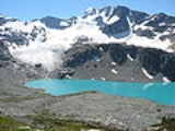
A 6 km (3.7 mi) steep hike leads to a backcountry shelter and camping area at Wedgemount LakeWedgemount Lake
Wedgemount Lake is a turquoise-coloured alpine lake in British Columbia, Canada located below Wedge Mountain.-See also:*Cascade Volcanoes*Garibaldi Lake volcanic field*Garibaldi Volcanic Belt*Garibaldi Provincial Park-External links:*...
, which is an approximately three hour hike to the lake (without heavy gear) from a parking lot near the Wedgemont railstop and track-crossing of the CNR near the foot of Green Lake
Green Lake (Whistler)
Green Lake is the largest and most northerly lake in the Resort Municipality of Whistler, British Columbia, Canada. It is the source of the Green River, a tributary of the Lillooet River, and is fed by the River of Golden Dreams, which issues from Alta Lake, which is at the height of land dividing...
. Across Wedgemount Lake from the cabin is the glacier, and above that the summit. The cabin, located at the North end of the lake, is at approximately 1920 m (6,299 ft) feet. There are multiple ways of approaching the summit. The more direct way is a knife-edge ridge called the North Arete, which leads more or less directly to the summit, requiring a full complement of winter mountaineering equipment. Another route that can be taken without such tools is the South face. This part can be seen from the valley, appearing to be a steep rock-covered slope... which it is. To approach the South face parties must climb over the glacier to the West Couloir, across the bottom of it and up to the left. Most of Wedge is in a provincial park, so helicopters are not allowed to drop people off there. In the early 1970s the glacier that now almost reaches the eastern end of Wedgemount Lake extended into the lake and at its terminus was approximately ten metres in height.
See also
- Wedgemount LakeWedgemount LakeWedgemount Lake is a turquoise-coloured alpine lake in British Columbia, Canada located below Wedge Mountain.-See also:*Cascade Volcanoes*Garibaldi Lake volcanic field*Garibaldi Volcanic Belt*Garibaldi Provincial Park-External links:*...
- Mountain peaks of CanadaMountain peaks of CanadaThis article comprises three sortable tables of major mountain peaks of Canada.Topographic elevation is the vertical distance above the reference geoid, a precise mathematical model of the Earth's sea level as an equipotential gravitational surface. Topographic prominence is the elevation...
- Mountain peaks of North AmericaMountain peaks of North AmericaThis article comprises three sortable tables of major mountain peaks of greater North America.This article defines greater North America as the portion of the continental landmass of the Americas extending northward from Panama plus the islands surrounding that landmass...