
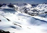
Juneau Icefield
Encyclopedia
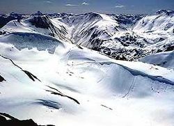
Ice field
An ice field is an area less than 50,000 km² of ice often found in the colder climates and higher altitudes of the world where there is sufficient precipitation. It is an extensive area of interconnected valley glaciers from which the higher peaks rise as nunataks...
located just north of Juneau
Juneau, Alaska
The City and Borough of Juneau is a unified municipality located on the Gastineau Channel in the panhandle of the U.S. state of Alaska. It has been the capital of Alaska since 1906, when the government of the then-District of Alaska was moved from Sitka as dictated by the U.S. Congress in 1900...
, Alaska
Alaska
Alaska is the largest state in the United States by area. It is situated in the northwest extremity of the North American continent, with Canada to the east, the Arctic Ocean to the north, and the Pacific Ocean to the west and south, with Russia further west across the Bering Strait...
and continues north through the border with British Columbia
British Columbia
British Columbia is the westernmost of Canada's provinces and is known for its natural beauty, as reflected in its Latin motto, Splendor sine occasu . Its name was chosen by Queen Victoria in 1858...
and is the fifth-largest ice field in the Western Hemisphere
Western Hemisphere
The Western Hemisphere or western hemisphere is mainly used as a geographical term for the half of the Earth that lies west of the Prime Meridian and east of the Antimeridian , the other half being called the Eastern Hemisphere.In this sense, the western hemisphere consists of the western portions...
, extending through an area of 3900 square kilometre in the Coast Range
Coast Mountains
The Coast Mountains are a major mountain range, in the Pacific Coast Ranges, of western North America, extending from southwestern Yukon through the Alaska Panhandle and virtually all of the Coast of British Columbia. They are so-named because of their proximity to the sea coast, and are often...
ranging 140 km (87 mi) north to south and 75 km (46.6 mi) east to west. The icefield is the source of many glacier
Glacier
A glacier is a large persistent body of ice that forms where the accumulation of snow exceeds its ablation over many years, often centuries. At least 0.1 km² in area and 50 m thick, but often much larger, a glacier slowly deforms and flows due to stresses induced by its weight...
s including the Mendenhall Glacier
Mendenhall Glacier
Mendenhall Glacier is a glacier about long located in Mendenhall Valley, about from downtown Juneau in the southeast area of the U.S. state of Alaska....
and the Taku Glacier
Taku Glacier
Taku Glacier is a tidewater glacier located in Taku Inlet in the U.S. state of Alaska, just southeast of the city of Juneau. Recognized as the deepest and thickest glacier known in the world, the Taku Glacier is measured at ....
. The icefield is home to over 40 large valley glaciers and 100 smaller ones. The Icefield serves as a tourist attraction with many travellers flown in by helicopter for quick walks on the 240 metre deep ice and the massive, awe-inspiring crevasse
Crevasse
A crevasse is a deep crack in an ice sheet rhys glacier . Crevasses form as a result of the movement and resulting stress associated with the sheer stress generated when two semi-rigid pieces above a plastic substrate have different rates of movement...
s. The icefield, like many of its glaciers, reached its maximum glaciation point around 1700 and has been in retreat since. In fact, of the icefield's 19 notable glaciers, the Taku Glacier is the only one presently advancing.
Since 1948, the Juneau Icefield Research Program has monitored glaciers of the Juneau Icefield. On the west side of the icefield, from 1946-2009, the terminus of the Mendenhall Glacier has retreated over 700 metre (0.434960915654865 mi).
Norris Glacier
Norris Glacier is a glacier flowing eastward between Kennedy Glacier and Mount Darby into the upper part of Matterhorn Glacier in Asgard Range, Victoria Land. Named by New Zealand Geographic Board after Baden Norris, Honorary Curator of the Antarctic collection, Canterbury Museum; historian who...
retreated 1740 m (1.1 mi), the East Twin Glacier 1100 m (0.683510010314787 mi), the West Twin Glacier 570 m (0.35418245989039 mi) with only the Taku Glacier advancing. Surveys reveal the Taku as one of the deepest glaciers of the sub-temperate icefields surveyed at nearly 1370 metres (4,494.8 ft) thick. This glacier was advancing in 1890 when viewed by John Muir
John Muir
John Muir was a Scottish-born American naturalist, author, and early advocate of preservation of wilderness in the United States. His letters, essays, and books telling of his adventures in nature, especially in the Sierra Nevada mountains of California, have been read by millions...
and had a large calving
Ice calving
Ice calving, also known as glacier calving or iceberg calving, is a form of ice ablation or ice disruption. It is the sudden release and breaking away of a mass of ice from a glacier, iceberg, ice front, ice shelf, or crevasse...
front. By 1963 the glacier had advanced 5.6 km (3.5 mi). In 1948 the Taku Fjord had been completely filled in with glacial sediment and the glacier no longer calved. From 1948–1986 the glacier had a positive glacier mass balance
Glacier mass balance
Crucial to the survival of a glacier is its mass balance, the difference between accumulation and ablation . Climate change may cause variations in both temperature and snowfall, causing changes in mass balance. Changes in mass balance control a glacier's long term behavior and is the most...
driving the advance. From 1987–2009 the glacier has had a slightly negative mass balance, not enough to end the advance, but if it continues will soon slow it.
A notable peak in the Juneau Icefield is Devils Paw
Devils Paw
Devils Paw is the high point of the Juneau Icefield, on the Alaska-British Columbia border. It is part of the Boundary Ranges of the Coast Mountains. It is also notable for its steep rise above the low local terrain...
, known locally with several smaller peaks as the Mendenhall Towers.
See also
- List of glaciers and icefields
- Retreat of glaciers since 1850Retreat of glaciers since 1850The retreat of glaciers since 1850 affects the availability of fresh water for irrigation and domestic use, mountain recreation, animals and plants that depend on glacier-melt, and in the longer term, the level of the oceans...
- Ha-Iltzuk IcefieldHa-Iltzuk IcefieldThe Ha-Iltzuk Icefield is an icefield in the central Pacific Ranges of the Coast Mountains in British Columbia, Canada. It is the largest icefield in the Coast Mountains south of the Alaska Panhandle, with an area of . It is located on the west side of the Klinaklini River and the Waddington Range...
- Homathko IcefieldHomathko IcefieldThe Homathko Icefield is an icefield in British Columbia, Canada. Officially named the Homathko Snowfield from 1950 until the current name was adopted in 1976, it is one of the largest icefields in the southern half of the Coast Mountains, with an area of over...
- Lillooet IcecapLillooet IcecapThe Lillooet Icecap, also called the Lillooet Icefield or the Lillooet Crown, is a large icefield in the Pacific Ranges of the Coast Mountains in southwestern British Columbia, Canada. It is about northwest of the towns of Pemberton and Whistler, and about north of Vancouver, British Columbia...
External links
- Terminus Behavior of Juneau Icefield Glaciers 1948-2005
- Forest Service overview
- Juneau Icefield Research Program
- Canadian Mountain Encyclopedia: Juneau Icefield entry
- crevassezone.org
- Pictures from the Juneau Icefield Research Program
- Pulitzer Center Crisis Reporting Juneau Icefield Research (multimedia)
- A description of the flora and fauna in the Icefield