

Cameroon line
Encyclopedia
.jpg)
It includes islands in the Gulf of Guinea
Gulf of Guinea
The Gulf of Guinea is the northeasternmost part of the tropical Atlantic Ocean between Cape Lopez in Gabon, north and west to Cape Palmas in Liberia. The intersection of the Equator and Prime Meridian is in the gulf....
and mountains that extend along the border region of eastern Nigeria
Nigeria
Nigeria , officially the Federal Republic of Nigeria, is a federal constitutional republic comprising 36 states and its Federal Capital Territory, Abuja. The country is located in West Africa and shares land borders with the Republic of Benin in the west, Chad and Cameroon in the east, and Niger in...
and western Cameroon
Cameroon
Cameroon, officially the Republic of Cameroon , is a country in west Central Africa. It is bordered by Nigeria to the west; Chad to the northeast; the Central African Republic to the east; and Equatorial Guinea, Gabon, and the Republic of the Congo to the south. Cameroon's coastline lies on the...
, from Mount Cameroon
Mount Cameroon
Mount Cameroon is an active volcano in Cameroon near the Gulf of Guinea. Mount Cameroon is also known as Cameroon Mountain or Fako or by its native name Mongo ma Ndemi ....
on the Gulf of Guinea
Gulf of Guinea
The Gulf of Guinea is the northeasternmost part of the tropical Atlantic Ocean between Cape Lopez in Gabon, north and west to Cape Palmas in Liberia. The intersection of the Equator and Prime Meridian is in the gulf....
north and east towards Lake Chad
Lake Chad
Lake Chad is a historically large, shallow, endorheic lake in Africa, whose size has varied over the centuries. According to the Global Resource Information Database of the United Nations Environment Programme, it shrank as much as 95% from about 1963 to 1998; yet it also states that "the 2007 ...
.
The islands, which span the equator, have tropical climates and are home to many unique plant and bird species.
The mainland mountain regions are much cooler than the surrounding lowlands, and also contain unique and ecologically important environments.
The Cameroon volcanic line is geologically unusual in extending through both the ocean and the continental crust. Various theories have been advanced by different geologists to explain the line.
Geography
Seamount
A seamount is a mountain rising from the ocean seafloor that does not reach to the water's surface , and thus is not an island. These are typically formed from extinct volcanoes, that rise abruptly and are usually found rising from a seafloor of depth. They are defined by oceanographers as...
s.
From the southwest to the northeast the island groups are Pagalu (or Annobón), São Tomé
São Tomé
-Transport:São Tomé is served by São Tomé International Airport with regular flights to Europe and other African Countries.-Climate:São Tomé features a tropical wet and dry climate with a relatively lengthy wet season and a short dry season. The wet season runs from October through May while the...
, Príncipe
Príncipe
Príncipe is the northern and smaller of the two major islands of the country of São Tomé and Príncipe lying off the west coast of Africa. It has an area of 136 km² and a population of approximately 5,000. The island is a heavily eroded volcano over three million years old, surrounded by other...
and Bioko
Bioko
Bioko is an island 32 km off the west coast of Africa, specifically Cameroon, in the Gulf of Guinea. It is the northernmost part of Equatorial Guinea with a population of 124,000 and an area of . It is volcanic with its highest peak the Pico Basile at .-Geography:Bioko has a total area of...
.
Two large seamounts lie between Sao Tome and Principe, and between Principe and Bioko.
On the mainland, the line starts with Mount Cameroon
Mount Cameroon
Mount Cameroon is an active volcano in Cameroon near the Gulf of Guinea. Mount Cameroon is also known as Cameroon Mountain or Fako or by its native name Mongo ma Ndemi ....
and extends northeast in a range known as the Western High Plateau
Western High Plateau
The Western High Plateau, Western Highlands, or Bamenda Grassfields is a region of Cameroon characterised by high relief, cool temperatures, heavy rainfall, and savanna vegetation. The region lies along the Cameroon line and consists of mountain ranges and volcanoes made of crystalline and igneous...
, home to the Cameroonian Highlands forests
Cameroonian Highlands forests
The Cameroonian Highlands forests are a montane tropical moist broadleaf forest ecoregion located on the range of mountains that runs inland from the Gulf of Guinea and forms the border between Cameroon and Nigeria...
. Volcanic swells further inland are Manengouba
Mount Manengouba
Mount Manengouba is a volcano in the Southwest Province of Cameroon. The Manenguba shrew and endemic vegetal species are native to the mountain. The area is featured in the documentary The Mists of Mwanenguba with botanist Martin Cheek....
, Bamboutu and the Oku Massif.
East of Oku there are further volcanic mountains in the Ngaoundere Plateau
Ngaoundere Plateau
The Ngaoundéré Plateau is a highland area in the Adamawa Region of Cameroon. It contains Tchabal Nganha, a large volcano, and many other recent volcanic structures.-Location:The plateau is between the forested south and Savannah north of Cameroon....
, some of which appear to have similar origins.
Annobón
The southernmost island in the chain is Annobón, also known as Pagalu, with an area of about 17.5 km² (6.8 sq mi).It is an extinct volcano that rises from deep water to 598 m (1,961.9 ft) above sea level.
The average temperature is 26.1 °C (79 °F), with little seasonal variation.
Most rain falls from November to May, with annual precipitation averaging 1196 mm (47.1 in) - less than on the mainland.
Annobón has lush valleys and steep mountains, covered with rich woods and luxuriant vegetation.
The island belongs to Equatorial Guinea
Equatorial Guinea
Equatorial Guinea, officially the Republic of Equatorial Guinea where the capital Malabo is situated.Annobón is the southernmost island of Equatorial Guinea and is situated just south of the equator. Bioko island is the northernmost point of Equatorial Guinea. Between the two islands and to the...
.
The small population lives in one community, practicing some agriculture but mainly living by fishing.
São Tomé

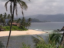
São Tomé Island is 854 km² (329.7 sq mi) in area, lying almost on the equator.
The entire island is a massive shield volcano
Shield volcano
A shield volcano is a type of volcano usually built almost entirely of fluid lava flows. They are named for their large size and low profile, resembling a warrior's shield. This is caused by the highly fluid lava they erupt, which travels farther than lava erupted from more explosive volcanoes...
which rises from the floor of the Atlantic Ocean
Atlantic Ocean
The Atlantic Ocean is the second-largest of the world's oceanic divisions. With a total area of about , it covers approximately 20% of the Earth's surface and about 26% of its water surface area...
, over 3000 m (9,842.5 ft) below sea level, and reaches 2024 m (6,640.4 ft) above sea level in the Pico de São Tomé
Pico de São Tomé
Pico de São Tomé is the highest mountain in São Tomé and Príncipe at 2,024 metres. It lies just west of the centre of São Tomé Island in the Obo National Park. The second highest point, Pico Ana Chaves, lies to its south east...
.
The oldest rock on Sao Tome is 13 million years old.
Most of the lava
Lava
Lava refers both to molten rock expelled by a volcano during an eruption and the resulting rock after solidification and cooling. This molten rock is formed in the interior of some planets, including Earth, and some of their satellites. When first erupted from a volcanic vent, lava is a liquid at...
erupted on São Tomé over the last million years has been basalt
Basalt
Basalt is a common extrusive volcanic rock. It is usually grey to black and fine-grained due to rapid cooling of lava at the surface of a planet. It may be porphyritic containing larger crystals in a fine matrix, or vesicular, or frothy scoria. Unweathered basalt is black or grey...
. The youngest dated rock on the island is about 100,000 years old, but numerous more recent cinder cone
Cinder cone
According to the , Cinder Cone is the proper name of 1 cinder cone in Canada and 7 cinder cones in the United States:In Canada: Cinder Cone In the United States:...
s are found on the southeast side of the island.
Due to the prevailing southwesterly winds, there is great variability in rainfall.
In the rain shadow to the northeast of Sao Tome the vegetation is dry savannah, with only 60 cm (23.6 in) of rain each year. By contrast, the lush south and west of the island receive about 6 m (19.7 ft) of rain, mostly falling in March and April.
The climate is hot and humid with the rainy season from October to May.
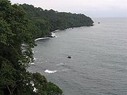
The higher slopes of the island are forested and form part of the Obo National Park.
São Tomé has never been connected to Africa, and therefore has many unique plants and birds.
Of the bird species, 16 are endemic and six are near endemic, of which four are only shared with Príncipe. Six species are considered vulnerable
Vulnerable species
On 30 January 2010, the IUCN Red List of Threatened Species identified 9694 Vulnerable species, subspecies and varieties, stocks and sub-populations.-References:...
, and three are critically endangered
Critically endangered
Version 2010.3 of the IUCN Red List of Threatened Species identified 3744 Critically Endangered species, subspecies and varieties, stocks and subpopulations.Critically Endangered by kingdom:*1993 Animalia*2 Fungi*1745 Plantae*4 Protista-References:...
(São Tomé Ibis, São Tomé Fiscal
São Tomé Fiscal
The São Tomé Fiscal is a species of bird in the Laniidae family. It is endemic to São Tomé and Príncipe. It is 20 to 21 centimeters long...
and São Tomé Grosbeak
São Tomé Grosbeak
The São Tomé Grosbeak, Neospiza concolor, is a large, chunky finch with a massive bill. It is endemic to the island of São Tomé.Until recently this bird was known only from three nineteenth century specimens. It was rediscovered in 1991. The current population is estimated at less than 50. The main...
).
Schistometopum thomense
Schistometopum thomense
Schistometopum thomense is a species of amphibian in the family Caeciliidae.It is endemic to São Tomé and Ilhéu das Rolas.It is found in most soil on São Tomé, from tropical moist lowland forests to coastal coconut plantations. It is absent only from the driest northern areas of the island...
, a bright yellow species of caecilian
Caecilian
The caecilians are an order of amphibians that superficially resemble earthworms or snakes. They mostly live hidden in the ground, making them the least familiar order of amphibians. All extant caecilians and their closest fossil relatives are grouped as the clade Apoda. They are mostly...
, is endemic to São Tomé.
As of 2010, São Tomé and Príncipe
São Tomé and Príncipe
São Tomé and Príncipe, officially the Democratic Republic of São Tomé and Príncipe, is a Portuguese-speaking island nation in the Gulf of Guinea, off the western equatorial coast of Central Africa. It consists of two islands: São Tomé and Príncipe, located about apart and about , respectively, off...
, an independent nation, had an estimated population of 167,000, most of whom lived on São Tomé island. The main language is Portuguese
Portuguese language
Portuguese is a Romance language that arose in the medieval Kingdom of Galicia, nowadays Galicia and Northern Portugal. The southern part of the Kingdom of Galicia became independent as the County of Portugal in 1095...
, but there are many speakers of Forro
Forro language
Forro is a Portuguese-based creole language spoken in São Tomé and Príncipe.The name means "freed slave" in Portuguese. The language is also called crioulo santomense. It should not be confused with the dialect of Portuguese spoken in São Tomé and Príncipe.- History :São Tomé is an island of the...
and Angolar
Angolar language
Angolar, also Ngola is a minority language of São Tomé and Príncipe, spoken in the southernmost towns of São Tomé Island and sparsely along the coast. It is a creole language, based partially on Portuguese with a heavy substrate of a dialect of Kimbundu Angolar, also Ngola (Lungua N'golá) is a...
(Ngola), two Portuguese-based creole language
Creole language
A creole language, or simply a creole, is a stable natural language developed from the mixing of parent languages; creoles differ from pidgins in that they have been nativized by children as their primary language, making them have features of natural languages that are normally missing from...
s.
The economy is mainly based on tourism. Agriculture
Agriculture
Agriculture is the cultivation of animals, plants, fungi and other life forms for food, fiber, and other products used to sustain life. Agriculture was the key implement in the rise of sedentary human civilization, whereby farming of domesticated species created food surpluses that nurtured the...
is important near the north and east coasts, with the chief exports being cocoa, coffee
Coffee
Coffee is a brewed beverage with a dark,init brooo acidic flavor prepared from the roasted seeds of the coffee plant, colloquially called coffee beans. The beans are found in coffee cherries, which grow on trees cultivated in over 70 countries, primarily in equatorial Latin America, Southeast Asia,...
, copra
Copra
Copra is the dried meat, or kernel, of the coconut. Coconut oil extracted from it has made copra an important agricultural commodity for many coconut-producing countries. It also yields coconut cake which is mainly used as feed for livestock.-Production:...
, and palm products.
There are large reserves of oil in the ocean between Nigeria
Nigeria
Nigeria , officially the Federal Republic of Nigeria, is a federal constitutional republic comprising 36 states and its Federal Capital Territory, Abuja. The country is located in West Africa and shares land borders with the Republic of Benin in the west, Chad and Cameroon in the east, and Niger in...
and São Tomé which have not yet been exploited.
Príncipe
Príncipe is the smaller of the two major islands of São Tomé and PríncipeSão Tomé and Príncipe
São Tomé and Príncipe, officially the Democratic Republic of São Tomé and Príncipe, is a Portuguese-speaking island nation in the Gulf of Guinea, off the western equatorial coast of Central Africa. It consists of two islands: São Tomé and Príncipe, located about apart and about , respectively, off...
, with an area of 136 km² (52.5 sq mi).
Volcanic activity stopped around 15.7 million years ago, and the island has been deeply eroded apart from spectacular towers of phonolite.
The island is surrounded by smaller islands including Ilheu Bom Bom
Ilheu Bom Bom
Ilhéu Bom Bom, also Ilhéu Bombom is an island in the Gulf of Guinea. The islet is located north of the coast of the island of Príncipe, one of the main islands of São Tomé and Príncipe. The island includes a couple of tourist resorts in São Tomé and Príncipe....
, Ilhéu Caroço
Ilhéu Caroço
Ilhéu Caroço is an island in the Gulf of Guinea and is one of the smaller islands of São Tomé and Príncipe. The islet is located southeast of the island of Príncipe....
, Tinhosa Grande
Tinhosa Grande
Tinhosa Grande is an islet in São Tomé and Príncipe located northeast of the main island of São Tomé and approximately southwest of the island of Príncipe...
and Tinhosa Pequena
Tinhosa Pequena
Tinhosa Pequena is an islet in São Tomé and Príncipe located northeast of the main island of São Tomé and approximately southwest of the island of Príncipe...
, and lies in ocean 3000 m (9,842.5 ft) deep.
It rises in the south to 946 m (3,103.7 ft) at Pico de Príncipe
Pico de Príncipe
Pico de Príncipe is a mountain on the island of Príncipe, the smaller of the two inhabited islands of São Tomé and Príncipe. The elevation of the mountain is generally given as , making it the highest peak on the island, but a trip to the peak in 1999 found that it may be lower than that, making...
, in a thickly forest
Forest
A forest, also referred to as a wood or the woods, is an area with a high density of trees. As with cities, depending where you are in the world, what is considered a forest may vary significantly in size and have various classification according to how and what of the forest is composed...
ed area within the Obo National Park. The north and centre of the island were formerly plantation
Plantation
A plantation is a long artificially established forest, farm or estate, where crops are grown for sale, often in distant markets rather than for local on-site consumption...
s but have largely reverted to forest.
As with São Tomé, the island has always been isolated from the mainland and therefore has many unique species of plants and animals, including six endemic birds.
Príncipe has a population of around 5,000 people. Other than Portuguese
Portuguese language
Portuguese is a Romance language that arose in the medieval Kingdom of Galicia, nowadays Galicia and Northern Portugal. The southern part of the Kingdom of Galicia became independent as the County of Portugal in 1095...
, some speak Principense
Principense language
The Principense language, called lunguyê by its speakers, is a Portuguese creole spoken in a community of some four thousand people in São Tomé and Príncipe, specifically on the island of Príncipe , according to a 1989 study...
or Lunguyê with a few Forro
Forro language
Forro is a Portuguese-based creole language spoken in São Tomé and Príncipe.The name means "freed slave" in Portuguese. The language is also called crioulo santomense. It should not be confused with the dialect of Portuguese spoken in São Tomé and Príncipe.- History :São Tomé is an island of the...
speakers.
Bioko
Bioko is just 32 km (19.9 mi) off the coast of Cameroon
Cameroon
Cameroon, officially the Republic of Cameroon , is a country in west Central Africa. It is bordered by Nigeria to the west; Chad to the northeast; the Central African Republic to the east; and Equatorial Guinea, Gabon, and the Republic of the Congo to the south. Cameroon's coastline lies on the...
, on the continental shelf.
The island used to be the end of a peninsula attached to the mainland, but was cut off when sea levels rose 10,000 years ago at the end of the last ice age
Ice age
An ice age or, more precisely, glacial age, is a generic geological period of long-term reduction in the temperature of the Earth's surface and atmosphere, resulting in the presence or expansion of continental ice sheets, polar ice sheets and alpine glaciers...
.
With an area of 2017 km² (779 sq mi) it is the largest island in the Cameroon line.
Bioko has three basaltic shield volcanoes, joining at the lower levels.
San Carlos is 2260 m (7,414.7 ft) high with a broad summit caldera, lying at the extreme SW of the island. The volcano dates from the Holocene
Holocene
The Holocene is a geological epoch which began at the end of the Pleistocene and continues to the present. The Holocene is part of the Quaternary period. Its name comes from the Greek words and , meaning "entirely recent"...
age and has been active within the last 2000 years.
Santa Isabel is the largest volcano at 3007 m (9,865.5 ft) in height, and contains many satellite cinder cones.
Three eruptions have been reported from vents on the southeast flank during the late-19th and early-20th centuries.
San Joaquin, also known as Pico Biao or Pico do Moka, is 2009 m (6,591.2 ft) high, on the southeast of the island.
The summit is cut by a small lake-filled caldera, and there is a crater lake on the NE flank.
San Joaquin has also been active during the last 2000 years.
The southwestern side of Bioko is rainy for most of the year, with annual rainfall in some locations of 10000 mm (394 in).
The climate is tropical at lower altitudes, becoming about 1 C-change cooler for each 150 m (492 ft) of elevation.
There is open canopy montane forest above 1500 m (4,921.3 ft) on Pico Basilé, Gran Caldera de Luba and Pico Biao, with subalpine grassland above 2500 m (8,202.1 ft).
Bioko has exceptional numbers of endemic species of flora and fauna, partly due to the great range of altitudes, particularly birdlife.
The montane forest is protected by the 330 km² (127.4 sq mi) Basilé National Park and the 510 km² (196.9 sq mi) Luba Crater Scientific Reserve. There has been little habitat loss, and the southern slopes have remained almost completely undisturbed.
Although hunting pressure is rising, the fauna in the inaccessible southern part of the island is mostly intact.
This includes an endemic subspecies of drill, Mandrillus leucophaeus poensis.
Bioko is part of the Republic of Equatorial Guinea
Equatorial Guinea
Equatorial Guinea, officially the Republic of Equatorial Guinea where the capital Malabo is situated.Annobón is the southernmost island of Equatorial Guinea and is situated just south of the equator. Bioko island is the northernmost point of Equatorial Guinea. Between the two islands and to the...
. It has a population of 124,000, most of whom are Bubi. The rest of the population are Fernandinos, Spaniards and immigrants from Río Muni
Río Muni
Río Muni is the Continental Region of Equatorial Guinea, and comprises the mainland geographical region, covering 26,017 km².-History:Río Muni was ceded by Portugal to Spain in 1778 in the Treaty of El Pardo...
, Nigeria
Nigeria
Nigeria , officially the Federal Republic of Nigeria, is a federal constitutional republic comprising 36 states and its Federal Capital Territory, Abuja. The country is located in West Africa and shares land borders with the Republic of Benin in the west, Chad and Cameroon in the east, and Niger in...
and Cameroon
Cameroon
Cameroon, officially the Republic of Cameroon , is a country in west Central Africa. It is bordered by Nigeria to the west; Chad to the northeast; the Central African Republic to the east; and Equatorial Guinea, Gabon, and the Republic of the Congo to the south. Cameroon's coastline lies on the...
.
Cocoa production was once the main export, but has declined in recent years. Farming, fishing and logging remain important.
Natural gas is produced in offshore wells, processed on the island and exported via tanker.
Western High Plateau
The Western High Plateau, also called the Western Highlands or the Bamenda Grassfields, continues the Cameroon line into the mainland of CameroonCameroon
Cameroon, officially the Republic of Cameroon , is a country in west Central Africa. It is bordered by Nigeria to the west; Chad to the northeast; the Central African Republic to the east; and Equatorial Guinea, Gabon, and the Republic of the Congo to the south. Cameroon's coastline lies on the...
.
The plateau rises in steps from the west. To the east, it terminates in mountains that range in height from 1000 m (3,280.8 ft) to 2500 metres (8,202.1 ft).
The plateau gives way to the Adamawa Plateau
Adamawa Plateau
The Adamawa Plateau is a plateau region in west-central Africa stretching from south-eastern Nigeria through north-central Cameroon to the Central African Republic. The plateau was named after Fulani Muslim leader Modibo Adama. The part of the plateau that lies in Nigeria is more popularly known...
to the northeast, a larger but less rugged region.
Volcanism

Volcano
2. Bedrock3. Conduit 4. Base5. Sill6. Dike7. Layers of ash emitted by the volcano8. Flank| 9. Layers of lava emitted by the volcano10. Throat11. Parasitic cone12. Lava flow13. Vent14. Crater15...
es, including the Bamboutos Mountains, Mount Oku
Mount Oku
Mount Oku, or Kilum Mountain, is the largest volcano in the Oku Massif, in the Cameroon Volcanic Line, located in the Oku region of the Western High Plateau of Cameroon.It is the second highest mountain in mainland West Africa....
, and Mount Kupe.
Crater lake
Crater lake
A crater lake is a lake that forms in a volcanic crater or caldera, such as a maar; less commonly and with lower association to the term a lake may form in an impact crater caused by a meteorite. Sometimes lakes which form inside calderas are called caldera lakes, but often this distinction is not...
s dot the plateau, the result of dead volcanoes filling with water. This includes Lake Barombi Mbo
Lake Barombi Mbo
Lake Barombi Mbo or Barombi-Ma-Mbu is a lake in the Southwest Region of Cameroon. It is located in the Cameroon volcanic chain, and is the largest volcanic lake in this region. It is one of the oldest radiocarbon-dated lakes in Africa...
and Lake Bermin
Lake Bermin
Lake Bermin is a small lake in the volcanic chain in the Southwest Region of Cameroon. It is a volcanic lake with a crater rim that rises to a height of about...
, which have the highest number of endemic fishes per area recorded anywhere in the world.
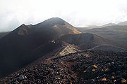
The 4095 m (13,435 ft) Mount Cameroon on the coastline, which may have been observed by the Carthaginian
Carthage
Carthage , implying it was a 'new Tyre') is a major urban centre that has existed for nearly 3,000 years on the Gulf of Tunis, developing from a Phoenician colony of the 1st millennium BC...
Hanno the Navigator
Hanno the Navigator
Hanno the Navigator was a Carthaginian explorer c. 500 BC, best known for his naval exploration of the African coast...
in the 5th century BC, erupted in 2000.
Further inland, the stratovolcano
Stratovolcano
A stratovolcano, also known as a composite volcano, is a tall, conical volcano built up by many layers of hardened lava, tephra, pumice, and volcanic ash. Unlike shield volcanoes, stratovolcanoes are characterized by a steep profile and periodic, explosive eruptions...
Mount Oku
Mount Oku
Mount Oku, or Kilum Mountain, is the largest volcano in the Oku Massif, in the Cameroon Volcanic Line, located in the Oku region of the Western High Plateau of Cameroon.It is the second highest mountain in mainland West Africa....
at 3011 metres (9,878.6 ft) is the second highest mountain in sub-Saharan mainland West Africa
West Africa
West Africa or Western Africa is the westernmost region of the African continent. Geopolitically, the UN definition of Western Africa includes the following 16 countries and an area of approximately 5 million square km:-Flags of West Africa:...
.
In 1986, Lake Nyos
Lake Nyos
Lake Nyos is a crater lake in the Northwest Region of Cameroon, located about northwest of Yaoundé. Nyos is a deep lake high on the flank of an inactive volcano in the Oku volcanic plain along the Cameroon line of volcanic activity...
, a crater lake in the Oku volcanic plain, released a cloud of carbon dioxide gas that killed at least 1,200 people.
Climate
The region has cool temperatures, heavy rainfall, and savannaSavanna
A savanna, or savannah, is a grassland ecosystem characterized by the trees being sufficiently small or widely spaced so that the canopy does not close. The open canopy allows sufficient light to reach the ground to support an unbroken herbaceous layer consisting primarily of C4 grasses.Some...
vegetation.
The plateau experiences an equatorial climate with a wet season of nine months, and a dry season of three months. During the wet season, humid, prevailing monsoon
Monsoon
Monsoon is traditionally defined as a seasonal reversing wind accompanied by corresponding changes in precipitation, but is now used to describe seasonal changes in atmospheric circulation and precipitation associated with the asymmetric heating of land and sea...
winds blow in from the west and lose their moisture upon hitting the region's mountains. Average rainfall per year ranges from 1000 mm (39.4 in) to 2000 mm (78.7 in).
High elevations give the region a cooler climate than the rest of Cameroon. For example, the average temperature at Dschang
Dschang
Dschang is a city located in the West Province of Cameroon, with an estimated population of 87,000 in 2001, growing dramatically from 21,705 recorded in 1981. The 2006 Population is estimated to be 200,000 inhabitants....
in the West Province
West Province (Cameroon)
The West Region is 14,000 km² of territory located in the central-western portion of the Republic of Cameroon. It borders the Northwest Region to the northwest, the Adamawa Region to the northeast, the Centre Region to the southeast, the Littoral Region to the southwest, and the Southwest...
is 20 °C (68 °F).
Toward the north, rainfall levels are reduced as the Sudan climate becomes predominant.
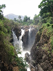
Important rivers in the region include the Manyu
Manyu River
The Manyu River rises near Wabane in the Upper Banyang Subdivision of the Manyu Department of the Southwest Region, Cameroon.The river runs past the southern border of the Mone River Forest Reserve. Below Mamfe, it is joined by rivers draining the Takamanda Forest Reserve and the Cross River...
, which rises in the Bamboutos Mountains and becomes the Cross River
Cross River (Nigeria)
Cross River is the main river in southeastern Nigeria and gives its name to Cross River State.It originates in Cameroon, where it takes the name of the Manyu River....
on its lower course, and the Nkam
Nkam River
The Nkam River rises in the Western High Plateau in the West Region of Cameroon, and joins the Makombé River to become the Wouri River. It is known to tourists for the spectacular Chutes d'Ekom, an high waterfall about from Bafang....
, which is known as the Wouri River
Wouri River
The Wouri is a river in Cameroon. The river is formed at the confluence of the rivers Nkam and Makombé, northeast of the city of Yabassi. The Wouri then flows about southeast to the Wouri estuary at Douala, the chief port and industrial city in the southwestern part of Cameroon on the Gulf of...
on its lower course.
The region gives rise to important tributaries to the Sanaga River
Sanaga River
The Sanaga River is a river of South Province, Cameroon, Centre Province, Cameroon, and West Province, Cameroon. Its length is 890 kilometers.The Sanaga River forms a boundary between two tropical moist forest ecoregions...
.
These rivers have a long high-water period during the wet season and a short low-water period during the dry season.
Environment
Volcanism has created fertile black and brown soils.The Western High Plateau was once heavily forested. However, repeated cutting and burning by human beings has forced the forest back to areas along the waterways and has allowed grasslands to expand into the area.
Sudan savanna
Savanna
A savanna, or savannah, is a grassland ecosystem characterized by the trees being sufficiently small or widely spaced so that the canopy does not close. The open canopy allows sufficient light to reach the ground to support an unbroken herbaceous layer consisting primarily of C4 grasses.Some...
forms the dominant vegetation. This consists of grassfields—leading to the name Bamenda grassfields around the city of Bamenda
Bamenda
Bamenda, also known as Abakwa and Mankon Town, is a city in northwestern Cameroon and capital of the North West Province. The city had a population of 269,530 at the 2005 Census, and is located 366 km north-west of the Cameroonian capital, Yaoundé...
—and short shrubs and trees that shed their foliage during the dry season as a defence against brush fires and dry weather. Raffia palm
Raffia palm
The Raffia palms are a genus of twenty species of palms native to tropical regions of Africa, especially Madagascar, with one species also occurring in Central and South America. They grow up to 16 m tall and are remarkable for their compound pinnate leaves, the longest in the plant kingdom;...
s grow in the valleys and depressions.
Neighboring volcanic regions
Although geographers may limit the Cameroon line to the volcanoes in the island chain and the Western High Plateau, many geologists also include the Ngaoundere Plateau which extends the line to the east in the Adamawa plateauAdamawa Plateau
The Adamawa Plateau is a plateau region in west-central Africa stretching from south-eastern Nigeria through north-central Cameroon to the Central African Republic. The plateau was named after Fulani Muslim leader Modibo Adama. The part of the plateau that lies in Nigeria is more popularly known...
, and some would also include the Biu plateau
Biu Plateau
The Biu Plateau is a highland area in Northeastern Nigeria containing many recently extinct volcanoes. It covers about and has an average elevation of . The plateau lies between the Upper Benue Basin to the south and the Chad Basin to the north. High points are Wade Hill at above sea level and...
and the Jos Plateau
Jos Plateau
The Jos Plateau is a plateau located near the center of Nigeria. It covers 8600 km² and is bounded by 300-600 meter escarpments around much of its circumference. With an average altitude of 1280 metres and its highest point is Shere Hills 1829 meters...
in Nigeria.
Geology
Geologists disagree over which volcanic regions should be included in the Cameroon Volcanic Line. All include the island line and the continental line up to Oku. Based on similarities in age and composition, some also include the Ngaoundere Plateau, the Biu plateauBiu Plateau
The Biu Plateau is a highland area in Northeastern Nigeria containing many recently extinct volcanoes. It covers about and has an average elevation of . The plateau lies between the Upper Benue Basin to the south and the Chad Basin to the north. High points are Wade Hill at above sea level and...
of Nigeria
Nigeria
Nigeria , officially the Federal Republic of Nigeria, is a federal constitutional republic comprising 36 states and its Federal Capital Territory, Abuja. The country is located in West Africa and shares land borders with the Republic of Benin in the west, Chad and Cameroon in the east, and Niger in...
to the north of the Yola arm of the Benue Trough, and the Jos Plateau
Jos Plateau
The Jos Plateau is a plateau located near the center of Nigeria. It covers 8600 km² and is bounded by 300-600 meter escarpments around much of its circumference. With an average altitude of 1280 metres and its highest point is Shere Hills 1829 meters...
to the west of the Benue Trough.
There are varying theories for the similarities between the oceanic and continental volcanoes.
Surrounding plate
The Cameroon line bisects the angle where the coast of AfricaAfrica
Africa is the world's second largest and second most populous continent, after Asia. At about 30.2 million km² including adjacent islands, it covers 6% of the Earth's total surface area and 20.4% of the total land area...
makes a 90° bend from the southern coast along the west of the Congo craton
Congo craton
The Congo craton, covered by the Palaeozoic-to-recent Congo basin, is an ancient Precambrian craton that with four others makes up the modern continent of Africa. These cratons were formed between about 3.6 and 2.0 billion years ago and have been tectonically stable since that time...
and the western coast along the south of the West African craton
West African craton
The West African craton is one of the five large masses, or cratons, of the Precambrian basement rock of Africa that make up the African Plate, the others being the Kalahari craton, Congo craton, Saharan Metacraton and Tanzania craton. These land masses came together in the late Precambrian and...
.
The coastline roughly corresponds to the coast of the Borborema geological province of northeastern Brazil
Brazil
Brazil , officially the Federative Republic of Brazil , is the largest country in South America. It is the world's fifth largest country, both by geographical area and by population with over 192 million people...
, which began to separate from this part Africa around 115 million years ago.
The Central African Shear Zone
Central African Shear Zone
The Central African Shear Zone is a wrench fault system extending in an ENE direction from the Gulf of Guinea through Cameroon into Sudan.The structure is not well understood....
(CASZ), a lineament
Lineament
See also Line A lineament is a linear feature in a landscape which is an expression of an underlying geological structure such as a fault. Typically a lineament will comprise a fault-aligned valley, a series of fault or fold-aligned hills, a straight coastline or indeed a combination of these...
that extends from the Sudan
Sudan
Sudan , officially the Republic of the Sudan , is a country in North Africa, sometimes considered part of the Middle East politically. It is bordered by Egypt to the north, the Red Sea to the northeast, Eritrea and Ethiopia to the east, South Sudan to the south, the Central African Republic to the...
to coastal Cameroon, runs under the continental section of the Cameroon line. It is visible in the Foumban Shear Zone
Foumban Shear Zone
The Foumban Shear Zone, or Central Cameroon Shear Zone , is a fault zone in Cameroon that has been identified with the Pernambuco fault in northeastern Brazil, which splays from the Trans-Brazilian Lineament....
, which was active before and during the opening of the South Atlantic in the Cretaceous
Cretaceous
The Cretaceous , derived from the Latin "creta" , usually abbreviated K for its German translation Kreide , is a geologic period and system from circa to million years ago. In the geologic timescale, the Cretaceous follows the Jurassic period and is followed by the Paleogene period of the...
period.
The western end of the shear zone
Shear zone
A shear zone is a very important structural discontinuity surface in the Earth's crust and upper mantle. It forms as a response to inhomogeneous deformation partitioning strain into planar or curviplanar high-strain zones. Intervening blocks stay relatively unaffected by the deformation...
is obscured by the volcanoes of the Cameroon line, but based on reconstruction of the configuration of South America before it separated from Africa, the Foumban Shear Zone can be identified with the Pernambuco fault
Pernambuco Fault
The Pernambuco fault or Pernambuco Shear Zone in northeastern Brazil is a splay fault radiating from the Transbrasiliano lineament eastwards to the coast, a major geological feature....
in Brazil.
A major earthquake in 1986 could indicate that the shear zone is reactivating.
The Benue Trough
Benue Trough
The Benue Trough is a major geological formation underlying a large part of Nigeria and extending about 1,000 km northeast from the Bight of Benin to Lake Chad.It is part of the broader Central African Rift System.-Location:...
lies to the west of the Cameroon line.
The Benue Trough was formed by rifting of the central West African basement, beginning at the start of the Cretaceous
Cretaceous
The Cretaceous , derived from the Latin "creta" , usually abbreviated K for its German translation Kreide , is a geologic period and system from circa to million years ago. In the geologic timescale, the Cretaceous follows the Jurassic period and is followed by the Paleogene period of the...
era.
A common explanation of the trough's formation is that it is an aulacogen
Aulacogen
In geology, an aulacogen is a failed arm of a triple junction of a plate tectonics rift system. A triple junction beneath a continental plate initiates a three way breakup of the continental plate. As the continental break-up develops one of the three spreading ridges typically fails or stops...
, an abandoned arm of a three-armed radial rift system. The other two arms continued to spread during the break-up of Gondwana
Gondwana
In paleogeography, Gondwana , originally Gondwanaland, was the southernmost of two supercontinents that later became parts of the Pangaea supercontinent. It existed from approximately 510 to 180 million years ago . Gondwana is believed to have sutured between ca. 570 and 510 Mya,...
, as South America separated from Africa.
During the Santonian
Santonian
The Santonian is an age in the geologic timescale or a chronostratigraphic stage. It is a subdivision of the Late Cretaceous epoch or Upper Cretaceous series. It spans the time between 85.8 ± 0.7 mya and 83.5 ± 0.7 mya...
age, around 84 million years ago, the Benue Trough underwent intense compression and folding.
Since then it has been tectonically quiet.
Theories
The basaltic rocks in the oceanic and continental sectors of the Cameroon line are similar in composition, although the more evolved rocks are quite distinct. The similarity in basaltic rocks may indicate they have the same source. Since the lithosphereLithosphere
The lithosphere is the rigid outermost shell of a rocky planet. On Earth, it comprises the crust and the portion of the upper mantle that behaves elastically on time scales of thousands of years or greater.- Earth's lithosphere :...
mantle below Africa must be different in chemical and isotopic composition from the younger lithosphere below the Atlantic, one explanation is that the source is in the asthenosphere
Asthenosphere
The asthenosphere is the highly viscous, mechanically weak and ductilely-deforming region of the upper mantle of the Earth...
rather than in metasomatized
Metasomatism
Metasomatism is the chemical alteration of a rock by hydrothermal and other fluids.Metasomatism can occur via the action of hydrothermal fluids from an igneous or metamorphic source. In the igneous environment, metasomatism creates skarns, greisen, and may affect hornfels in the contact...
lithosphere.
A different view is that the similarities are caused by shallow contamination of the oceanic section, which could be caused by sediments from the continent or by rafted crustal blocks that were trapped in the oceanic lithosphere during the separation between South America and Africa.
According to some geologists, there is evidence that a mantle plume
Mantle plume
A mantle plume is a hypothetical thermal diapir of abnormally hot rock that nucleates at the core-mantle boundary and rises through the Earth's mantle. Such plumes were invoked in 1971 to explain volcanic regions that were not thought to be explicable by the then-new theory of plate tectonics. Some...
has existed in the region for about 140 million years, first remaining in roughly the same position while the African plate rotated above it, and then remaining stationary under the Oku area since around 65 million years ago.
The abnormal heat rising in a mantle plume would lead to melting of the upper mantle, which raises, thins and weakens the crust
Crust (geology)
In geology, the crust is the outermost solid shell of a rocky planet or natural satellite, which is chemically distinct from the underlying mantle...
and facilitates rifting. This may have been repeated several times in the Benue Trough between 140 Ma and 49 Ma.
One theory for the later development of the Cameroon Line around 30 Ma is that it coincides with development of a shallow mantle convection system centered on the mantle plume, and is related to thinning and extension of the crust along the Cameroon line as pressures relaxed in the now stationary plate.
The mantle plume
Mantle plume
A mantle plume is a hypothetical thermal diapir of abnormally hot rock that nucleates at the core-mantle boundary and rises through the Earth's mantle. Such plumes were invoked in 1971 to explain volcanic regions that were not thought to be explicable by the then-new theory of plate tectonics. Some...
hypothesis is disputed by others, who say the region is quite different from what is predicted by that theory, and that a source in lithospheric fracture is more likely to be the explanation.
The line may be due to a more complex interaction between a hotspot and Precambrian faults.
A gravity study of the southern part of the Adamawa plateau
Adamawa Plateau
The Adamawa Plateau is a plateau region in west-central Africa stretching from south-eastern Nigeria through north-central Cameroon to the Central African Republic. The plateau was named after Fulani Muslim leader Modibo Adama. The part of the plateau that lies in Nigeria is more popularly known...
has shown a belt of dense rocks at an average depth of 8 km running parallel to the Foumban shear zone. The material appears to be an igneous intrusion that may have been facilitated by reactivation of the shear zone, and may be associated with the Cameroon line.
Sources
|url=http://www.birdlife.org/action/ground/bamenda/index.html|title=Conserving Afromontane Forest in the Bamenda Highlands of Cameroon
|publisher=BirdLife International
BirdLife International
BirdLife International is a global Partnership of conservation organisations that strives to conserve birds, their habitats and global biodiversity, working with people towards sustainability in the use of natural resources...
|accessdate=2011-02-06}}
|url=https://www.cia.gov/library/publications/the-world-factbook/geos/ek.html
|title=Equatorial Guinea
|publisher=CIA
|accessdate=2011-02-04}}
|url=http://www.volcano.si.edu/world/volcano.cfm?vnum=0204-01=
|publisher=Smithsonian
|title=Mount Cameroon
|accessdate=2011-02-01}}
|url=http://www.worldwildlife.org/wildworld/profiles/terrestrial/at/at0121_full.html
|title=Mount Cameroon and Bioko montane forests
|publisher=World Wildlife Fund
|accessdate=2011-02-04}}
|url=http://books.google.ca/books?id=FMRSzurkjkgC&pg=PA23&lpg=PA23
|journal=New Scientist
|date=12 Feb 1987
|title=Quake may have triggered Nyos disaster
|accessdate=2011-01-31 |author1 = Information, Reed Business}}
|url=http://www.volcano.si.edu/world/volcano.cfm?vnum=0204-002
|title=San Carlos
|publisher=Smithsonian
|accessdate=2011-02-04}}
|url=http://www.volcano.si.edu/world/volcano.cfm?vnum=0204-004
|title=Santa Isabel
|publisher=Smithsonian
|accessdate=2011-02-04}}
|url=http://www.volcano.si.edu/world/volcano.cfm?vnum=0204-003
|title=San Joaquin
|publisher=Smithsonian
|accessdate=2011-02-04}}
|title=São Tomé and Principe Geography
|publisher=CIA
|work=World Factbook}}
|url=http://www.volcano.si.edu/world/volcano.cfm?vnum=0204-001
|title=Sao Tome
|publisher=Smithsonian
|accessdate=2011-02-04}}
|url=http://www.state.gov/r/pa/ei/bgn/5434.htm
|title=São Tomé and Príncipe (Background Note)
|date=December 7, 2010
|publisher=US State Department
|accessdate=2011-02-04}}